Bridge Statistics for Winter Springs, Florida (FL)
Condition, Traffic, Stress, Structural Evaluation, Project Costs
- National Bridge Inventory (NBI) Statistics
- 28Number of bridges
- 200ft / 61.4mTotal length
- $74,000Total costs
- 503,757Total average daily traffic
- 51,686Total average daily truck traffic
- National Bridge Inventory (NBI) Registered Bridges for Winter Springs
- No street view available for this location
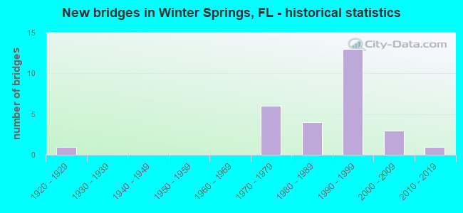
- New bridges - historical statistics
- 11920-1929
- 61970-1979
- 41980-1989
- 131990-1999
- 32000-2009
- 12010-2019


- Bridge Condition - Deck
- 22.2%Very good
- 55.6%Good
- 22.2%Fair

- Bridge Condition - Superstructure
- 16.7%Very good
- 55.6%Good
- 5.6%Satisfactory
- 22.2%Fair

- Bridge Condition - Substructure
- 27.8%Very good
- 72.2%Good

- Bridge Condition - Channel
- 10.5%Very good
- 42.1%Good
- 31.6%Satisfactory
- 15.8%Fair

- Bridge Condition - Culverts
- 16.7%Very good
- 50.0%Good
- 33.3%Satisfactory
Find on map >> Show street view
Structure Number: 7562, Location: 2.0 Mi West of SR-429 (Lat: 28.545208, Lng: -81.583464), Route carried "on" structure: City street , Year Built: 2007, Status: Open, Structure Length: 6.46m (21.19ft), Average Daily Traffic: 20,500 (year 2020), Truck Traffic: 6%, Average Future Daily Traffic: 35,568 (year 2042), Design Load: HL 93, Features Intersected: Florida Turnpike SR-91, Facility Carried by Structure: Daniels Road
Minimum Vertical Clearance: 30+ m (98+ ft), Kilometerpoint: 2.993, Lanes on structure: 4, Lanes under structure: 8, Owner: City or Municipal Highway Agency, Approaching Roadway Width: 20.0m (65.6ft), Skew: 20 degrees, Material/Design: Prestressed concrete, Design/Construction: Stringer/Multi-beam, Number Of Spans In Main Unit: 2, Length of Maximum Span: 32.3m (106.0ft), Curb or Sidewalk Widths: Left: 1.5m (4.9ft), Right: 3.0m (9.8ft), Curb-To-Curb Width: 20.0m (65.6ft), Out-to-Out Width: 25.8m (84.6ft)
Condition: Deck: Very good, Superstructure: Very good, Substructure: Very good, Operating Rating: 59.4 metric tons, Method Used To Determine Operating Rating: Load and Resistance Factor (LRFR), Inventory Rating: 46.7 metric tons, Method Used To Determine Inventory Rating: Load and Resistance Factor (LRFR), Structural Evaluation: Equal to present desirable criteria, Deck Geometry: Better than present minimum criteria, Underclear: Superior to present desirable criteria, Approach Roadway Alignment: Equal to present desirable criteria, Designated Inspection Frequency: Every 24 months, Inspection Date: July 2021, Deck Structure Type: Concrete Cast-file-Place
Find on map >> Show street view
Structure Number: 770014, Location: 2.6 Mi E of SR-600 (Lat: 28.703708, Lng: -81.290706), Route carried "on" structure: State highway 419, Year Built: 1927, Year Reconstructed: 1997, Status: Open, Structure Length: 1.04m (3.41ft), Average Daily Traffic: 34,000 (year 2020), Truck Traffic: 6%, Average Future Daily Traffic: 58,990 (year 2042), Design Load: H 20, Features Intersected: Gee Creek
Minimum Vertical Clearance: 30+ m (98+ ft), Kilometerpoint: 0.072, Lanes on structure: 4, Owner: State Highway Agency, Approaching Roadway Width: 16.7m (54.8ft), Skew: 20 degrees, Material/Design: Concrete, Design/Construction: Culvert, Number Of Spans In Main Unit: 3, Length of Maximum Span: 3.4m (11.2ft)
Condition: Channel: Fair, Culverts: Satisfactory, Operating Rating: 51.9 metric tons, Method Used To Determine Operating Rating: Load Factor (LF), Inventory Rating: 31.1 metric tons, Method Used To Determine Inventory Rating: Load Factor (LF), Structural Evaluation: Equal to present minimum criteria, Waterway Adequacy: Better than present minimum criteria, Approach Roadway Alignment: Equal to present desirable criteria, Length Of Structure Improvement: 0.98m (3.22ft), Designated Inspection Frequency: Every 24 months, Underwater Inspection Frequency: Every 24 months, Inspection Date: November 2021, Underwater Inspection Date: November 2021, Bridge Improvement Cost: $52,000, Total Project Cost: $74,000
Find on map >> Show street view
Structure Number: 770056, Location: 3 MI NORTH OF SLAVIA RD (Lat: 28.690178, Lng: -81.227986), Route carried "on" structure: State highway 417, Year Built: 1993, Status: Open, Structure Length: 4.35m (14.27ft), Average Daily Traffic: 28,400 (year 2020), Truck Traffic: 12%, Average Future Daily Traffic: 49,274 (year 2042), Design Load: HS 20+Mod, Features Intersected: SR 434
Minimum Vertical Clearance: 30+ m (98+ ft), Kilometerpoint: 9.769, Lanes on structure: 2, Lanes under structure: 6, Base Highway Network: Yes, Toll: On toll road, Owner: State Toll Authority, Approaching Roadway Width: 11.0m (36.1ft), Skew: 1 degrees, Material/Design: Prestressed concrete, Design/Construction: Stringer/Multi-beam, Number Of Spans In Main Unit: 1, Length of Maximum Span: 43.5m (142.7ft), Curb-To-Curb Width: 12.2m (40.0ft), Out-to-Out Width: 13.1m (43.0ft)
Condition: Deck: Very good, Superstructure: Satisfactory, Substructure: Very good, Operating Rating: 46.3 metric tons, Method Used To Determine Operating Rating: Load and Resistance Factor (LRFR), Inventory Rating: 41.4 metric tons, Method Used To Determine Inventory Rating: Load and Resistance Factor (LRFR), Structural Evaluation: Equal to present minimum criteria, Deck Geometry: Better than present minimum criteria, Underclear: Equal to present minimum criteria, Approach Roadway Alignment: Equal to present desirable criteria, Designated Inspection Frequency: Every 24 months, Inspection Date: December 2021, Deck Structure Type: Concrete Cast-file-Place
Find on map >> Show street view
Structure Number: 770057, Location: 3 MI NORTH OF SLAVIA RD (Lat: 28.690147, Lng: -81.227678), Route carried "on" structure: State highway 417, Year Built: 1993, Status: Open, Structure Length: 4.35m (14.27ft), Average Daily Traffic: 28,400 (year 2020), Truck Traffic: 12%, Average Future Daily Traffic: 49,274 (year 2042), Design Load: HS 20+Mod, Features Intersected: SR 434
Minimum Vertical Clearance: 30+ m (98+ ft), Kilometerpoint: 9.764, Lanes on structure: 2, Lanes under structure: 6, Base Highway Network: Yes, Toll: On toll road, Owner: State Toll Authority, Approaching Roadway Width: 11.5m (37.7ft), Skew: 1 degrees, Material/Design: Prestressed concrete, Design/Construction: Stringer/Multi-beam, Number Of Spans In Main Unit: 1, Length of Maximum Span: 43.5m (142.7ft), Curb-To-Curb Width: 12.2m (40.0ft), Out-to-Out Width: 13.1m (43.0ft)
Condition: Deck: Good, Superstructure: Good, Substructure: Very good, Operating Rating: 46.3 metric tons, Method Used To Determine Operating Rating: Load and Resistance Factor (LRFR), Inventory Rating: 41.4 metric tons, Method Used To Determine Inventory Rating: Load and Resistance Factor (LRFR), Structural Evaluation: Better than present minimum criteria, Deck Geometry: Better than present minimum criteria, Underclear: Equal to present minimum criteria, Approach Roadway Alignment: Equal to present desirable criteria, Designated Inspection Frequency: Every 24 months, Inspection Date: December 2021, Deck Structure Type: Concrete Cast-file-Place
Find on map >> Show street view
Structure Number: 770058, Location: 2.4 MI NORTH OF SLAVIA RD (Lat: 28.681961, Lng: -81.226242), Route carried "on" structure: State highway 417, Year Built: 1993, Status: Open, Structure Length: 2.36m (7.74ft), Average Daily Traffic: 28,400 (year 2020), Truck Traffic: 12%, Average Future Daily Traffic: 49,274 (year 2042), Design Load: HS 20+Mod, Features Intersected: PEDESTRIAN TRAIL
Minimum Vertical Clearance: 30+ m (98+ ft), Kilometerpoint: 8.845, Lanes on structure: 2, Base Highway Network: Yes, Toll: On toll road, Owner: State Toll Authority, Approaching Roadway Width: 11.6m (38.1ft), Skew: 4 degrees, Material/Design: Prestressed concrete, Design/Construction: Stringer/Multi-beam, Number Of Spans In Main Unit: 1, Length of Maximum Span: 23.6m (77.4ft), Curb-To-Curb Width: 13.6m (44.6ft), Out-to-Out Width: 14.5m (47.6ft)
Condition: Deck: Good, Superstructure: Good, Substructure: Good, Operating Rating: 40.4 metric tons, Method Used To Determine Operating Rating: Load and Resistance Factor (LRFR), Inventory Rating: 31.1 metric tons, Method Used To Determine Inventory Rating: Load and Resistance Factor (LRFR), Structural Evaluation: Better than present minimum criteria, Deck Geometry: Superior to present desirable criteria, Approach Roadway Alignment: Equal to present desirable criteria, Designated Inspection Frequency: Every 24 months, Inspection Date: January 2022, Deck Structure Type: Concrete Cast-file-Place
Find on map >> Show street view
Structure Number: 770059, Location: 2.4 MI NORTH OF SLAVIA RD (Lat: 28.681792, Lng: -81.225947), Route carried "on" structure: State highway 417, Year Built: 1993, Status: Open, Structure Length: 2.36m (7.74ft), Average Daily Traffic: 28,400 (year 2020), Truck Traffic: 12%, Average Future Daily Traffic: 49,274 (year 2042), Design Load: HS 20+Mod, Features Intersected: PEDESTRIAN TRAIL
Minimum Vertical Clearance: 30+ m (98+ ft), Kilometerpoint: 8.826, Lanes on structure: 2, Base Highway Network: Yes, Toll: On toll road, Owner: State Toll Authority, Approaching Roadway Width: 13.2m (43.3ft), Skew: 4 degrees, Material/Design: Prestressed concrete, Design/Construction: Stringer/Multi-beam, Number Of Spans In Main Unit: 1, Length of Maximum Span: 23.6m (77.4ft), Curb-To-Curb Width: 12.2m (40.0ft), Out-to-Out Width: 13.1m (43.0ft)
Condition: Deck: Good, Superstructure: Good, Substructure: Good, Operating Rating: 37.8 metric tons, Method Used To Determine Operating Rating: Load and Resistance Factor (LRFR), Inventory Rating: 29.2 metric tons, Method Used To Determine Inventory Rating: Load and Resistance Factor (LRFR), Structural Evaluation: Better than present minimum criteria, Deck Geometry: Better than present minimum criteria, Approach Roadway Alignment: Equal to present desirable criteria, Designated Inspection Frequency: Every 24 months, Inspection Date: January 2022, Deck Structure Type: Concrete Cast-file-Place
Find on map >> Show street view
Structure Number: 770072, Location: SR-434 - Howell Creek (Lat: 28.689894, Lng: -81.250094), Route carried "on" structure: State highway 434, Year Built: 1999, Status: Open, Structure Length: 10.73m (35.20ft), Average Daily Traffic: 23,500 (year 2020), Truck Traffic: 6%, Average Future Daily Traffic: 40,772 (year 2042), Design Load: HS 20+Mod, Features Intersected: Howell Creek
Minimum Vertical Clearance: 30+ m (98+ ft), Kilometerpoint: 8.998, Lanes on structure: 4, Owner: State Highway Agency, Approaching Roadway Width: 18.5m (60.7ft), Skew: 20 degrees, Material/Design: Prestressed concrete, Design/Construction: Stringer/Multi-beam, Number Of Spans In Main Unit: 7, Length of Maximum Span: 15.2m (49.9ft), Curb or Sidewalk Widths: Left: 1.5m (4.9ft), Right: 1.5m (4.9ft), Curb-To-Curb Width: 25.8m (84.6ft), Out-to-Out Width: 36.0m (118.1ft)
Condition: Deck: Good, Superstructure: Good, Substructure: Good, Channel: Very good, Operating Rating: 46.8 metric tons, Method Used To Determine Operating Rating: Load Factor (LF), Inventory Rating: 29.1 metric tons, Method Used To Determine Inventory Rating: Load Factor (LF), Structural Evaluation: Better than present minimum criteria, Deck Geometry: Superior to present desirable criteria, Waterway Adequacy: Equal to present desirable criteria, Approach Roadway Alignment: Equal to present desirable criteria, Designated Inspection Frequency: Every 24 months, Inspection Date: August 2021, Deck Structure Type: Concrete Cast-file-Place, Wearing Surface/Protective System: Wearing Surface: Monolithic Concrete
Find on map >> Show street view
Structure Number: 770076, Location: 1.0 mile west of SR-417 (Lat: 28.689928, Lng: -81.247528), Route carried "on" structure: State highway 434, Year Built: 1999, Status: Open, Structure Length: 1.47m (4.82ft), Average Daily Traffic: 23,500 (year 2020), Truck Traffic: 6%, Average Future Daily Traffic: 40,772 (year 2042), Design Load: HS 20+Mod, Features Intersected: Howell Creek
Minimum Vertical Clearance: 30+ m (98+ ft), Kilometerpoint: 9.302, Lanes on structure: 4, Owner: State Highway Agency, Approaching Roadway Width: 17.1m (56.1ft), Skew: 11 degrees, Material/Design: Concrete, Design/Construction: Culvert, Number Of Spans In Main Unit: 4, Length of Maximum Span: 3.3m (10.8ft)
Condition: Channel: Satisfactory, Culverts: Good, Operating Rating: 76.7 metric tons, Method Used To Determine Operating Rating: Load Factor (LF), Inventory Rating: 46.0 metric tons, Method Used To Determine Inventory Rating: Load Factor (LF), Structural Evaluation: Better than present minimum criteria, Waterway Adequacy: Better than present minimum criteria, Approach Roadway Alignment: Equal to present desirable criteria, Designated Inspection Frequency: Every 24 months, Underwater Inspection Frequency: Every 24 months, Inspection Date: October 2020, Underwater Inspection Date: October 2020
Find on map >> Show street view
Structure Number: 774036, Location: 0.3 mi S of Red Bug Lk Rd (Lat: 28.643078, Lng: -81.266306), Route carried "on" structure: County highway , Year Built: 1997, Status: Open, Structure Length: 1.83m (6.00ft), Average Daily Traffic: 33,500 (year 2021), Truck Traffic: 4%, Average Future Daily Traffic: 58,123 (year 2042), Design Load: HS 20, Features Intersected: Howell Creek, Facility Carried by Structure: Tuskawilla Rd NB
Minimum Vertical Clearance: 30+ m (98+ ft), Kilometerpoint: 0.000, Lanes on structure: 3, Owner: County Highway Agency, Approaching Roadway Width: 12.2m (40.0ft), Material/Design: Prestressed concrete, Design/Construction: Tee Beam, Number Of Spans In Main Unit: 1, Length of Maximum Span: 18.3m (60.0ft), Curb or Sidewalk Widths: Left: 0.0m, Right: 1.5m (4.9ft), Curb-To-Curb Width: 13.6m (44.6ft), Out-to-Out Width: 16.3m (53.5ft)
Condition: Deck: Good, Superstructure: Good, Substructure: Good, Channel: Good, Operating Rating: 58.1 metric tons, Method Used To Determine Operating Rating: Load Factor (LF), Inventory Rating: 34.5 metric tons, Method Used To Determine Inventory Rating: Load Factor (LF), Structural Evaluation: Better than present minimum criteria, Deck Geometry: Somewhat better than minimum adequacy, Waterway Adequacy: Equal to present desirable criteria, Approach Roadway Alignment: Equal to present desirable criteria, Designated Inspection Frequency: Every 24 months, Inspection Date: November 2021, Deck Structure Type: Concrete Cast-file-Place, Wearing Surface/Protective System: Wearing Surface: Bituminous
Find on map >> Show street view
Structure Number: 77404, Location: 0.3 Mi S of Red Bug Lk Rd (Lat: 28.643072, Lng: -81.266533), Route carried "on" structure: County highway , Year Built: 1997, Status: Open, Structure Length: 1.83m (6.00ft), Average Daily Traffic: 33,500 (year 2021), Truck Traffic: 4%, Average Future Daily Traffic: 58,123 (year 2042), Design Load: HS 20, Features Intersected: Howell Creek, Facility Carried by Structure: Tuskawilla Road SB
Minimum Vertical Clearance: 30+ m (98+ ft), Kilometerpoint: 0.000, Lanes on structure: 3, Owner: County Highway Agency, Approaching Roadway Width: 12.2m (40.0ft), Material/Design: Prestressed concrete, Design/Construction: Tee Beam, Number Of Spans In Main Unit: 1, Length of Maximum Span: 18.3m (60.0ft), Curb or Sidewalk Widths: Left: 1.5m (4.9ft), Right: 0.0m, Curb-To-Curb Width: 13.6m (44.6ft), Out-to-Out Width: 16.3m (53.5ft)
Condition: Deck: Very good, Superstructure: Very good, Substructure: Very good, Channel: Good, Operating Rating: 58.1 metric tons, Method Used To Determine Operating Rating: Load Factor (LF), Inventory Rating: 34.5 metric tons, Method Used To Determine Inventory Rating: Load Factor (LF), Structural Evaluation: Equal to present desirable criteria, Deck Geometry: Somewhat better than minimum adequacy, Waterway Adequacy: Equal to present desirable criteria, Approach Roadway Alignment: Equal to present desirable criteria, Designated Inspection Frequency: Every 24 months, Inspection Date: November 2021, Deck Structure Type: Concrete Cast-file-Place, Wearing Surface/Protective System: Wearing Surface: Bituminous
Find on map >> Show street view
Structure Number: 774063, Location: 0.5 Mi E of Tuskawilla Rd (Lat: 28.660639, Lng: -81.266583), Route carried "on" structure: City street , Year Built: 2013, Status: Open, Structure Length: 1.89m (6.20ft), Average Daily Traffic: 3,437 (year 2013), Truck Traffic: 5%, Average Future Daily Traffic: 4,373 (year 2033), Design Load: HL 93, Features Intersected: Howell Creek, Facility Carried by Structure: Dyson Drive
Minimum Vertical Clearance: 30+ m (98+ ft), Kilometerpoint: 0.000, Lanes on structure: 2, Owner: County Highway Agency, Approaching Roadway Width: 8.4m (27.6ft), Material/Design: Prestressed concrete, Design/Construction: Stringer/Multi-beam, Number Of Spans In Main Unit: 1, Length of Maximum Span: 18.9m (62.0ft), Curb or Sidewalk Widths: Left: 2.0m (6.6ft), Right: 0.0m, Curb-To-Curb Width: 8.4m (27.6ft), Out-to-Out Width: 11.3m (37.1ft)
Condition: Deck: Very good, Superstructure: Very good, Substructure: Very good, Channel: Very good, Operating Rating: 60.4 metric tons, Method Used To Determine Operating Rating: Load and Resistance Factor (LRFR), Inventory Rating: 46.4 metric tons, Method Used To Determine Inventory Rating: Load and Resistance Factor (LRFR), Structural Evaluation: Equal to present desirable criteria, Deck Geometry: High priority of corrective action, Waterway Adequacy: Equal to present desirable criteria, Approach Roadway Alignment: Equal to present desirable criteria, Designated Inspection Frequency: Every 24 months, Inspection Date: June 2021, Deck Structure Type: Concrete Cast-file-Place
Find on map >> Show street view
Structure Number: 775703, Location: .5 Mi S of Wintr Sprng Bl (Lat: 28.666903, Lng: -81.259508), Route carried "on" structure: City street , Year Built: 1973, Status: Posted for load, Structure Length: 1.41m (4.63ft), Average Daily Traffic: 2,883 (year 2020), Truck Traffic: 5%, Average Future Daily Traffic: 3,667 (year 2042), Design Load: HS 20, Features Intersected: Howell Creek, Facility Carried by Structure: Northern Way
Minimum Vertical Clearance: 30+ m (98+ ft), Kilometerpoint: 0.000, Lanes on structure: 2, Owner: City or Municipal Highway Agency, Approaching Roadway Width: 8.5m (27.9ft), Material/Design: Prestressed concrete, Design/Construction: Channel Beam, Number Of Spans In Main Unit: 1, Length of Maximum Span: 14.1m (46.3ft), Curb or Sidewalk Widths: Left: 1.2m (3.9ft), Right: 0.2m (0.7ft), Curb-To-Curb Width: 8.5m (27.9ft), Out-to-Out Width: 10.7m (35.1ft)
Condition: Deck: Good, Superstructure: Good, Substructure: Good, Channel: Satisfactory, Operating Rating: 25.7 metric tons, Method Used To Determine Operating Rating: Load Factor (LF), Inventory Rating: 15.4 metric tons, Method Used To Determine Inventory Rating: Load Factor (LF), Structural Evaluation: Meets minimum limits, Deck Geometry: Meets minimum limits, Waterway Adequacy: Equal to present desirable criteria, Approach Roadway Alignment: Better than present minimum criteria, Bridge Posting: Required (Relationship of Operating Rating to Maximum Legal Load: 30.0 - 39.9% below), Designated Inspection Frequency: Every 24 months, Other Special Inspection Frequency: Every 12 months, Inspection Date: June 2020, Other Special Inspection Date: June 2021, Deck Structure Type: Concrete Cast-file-Place
Find on map >> Show street view
Structure Number: 775704, Location: .25 mi S of S Edgemon Ave (Lat: 28.686631, Lng: -81.307853), Route carried "on" structure: City street , Year Built: 1973, Status: Open, Structure Length: 1.28m (4.20ft), Average Daily Traffic: 2,789 (year 2020), Truck Traffic: 5%, Average Future Daily Traffic: 3,542 (year 2042), Design Load: H 20, Features Intersected: Gee Creek, Facility Carried by Structure: Murphy Road
Minimum Vertical Clearance: 30+ m (98+ ft), Kilometerpoint: 0.016, Lanes on structure: 2, Owner: City or Municipal Highway Agency, Approaching Roadway Width: 8.1m (26.6ft), Skew: 2 degrees, Material/Design: Concrete, Design/Construction: Culvert, Number Of Spans In Main Unit: 3, Length of Maximum Span: 4.1m (13.5ft), Curb or Sidewalk Widths: Left: 0.0m, Right: 1.4m (4.6ft)
Condition: Channel: Fair, Culverts: Satisfactory, Operating Rating: 64.5 metric tons, Method Used To Determine Operating Rating: Load Factor (LF), Inventory Rating: 38.7 metric tons, Method Used To Determine Inventory Rating: Load Factor (LF), Structural Evaluation: Equal to present minimum criteria, Waterway Adequacy: Equal to present desirable criteria, Approach Roadway Alignment: Equal to present desirable criteria, Designated Inspection Frequency: Every 24 months, Inspection Date: June 2020
Find on map >> Show street view
Structure Number: 775705, Location: 0.8 mile South of SR-434 (Lat: 28.687978, Lng: -81.306136), Route carried "on" structure: City street , Year Built: 1973, Status: Open, Structure Length: 1.14m (3.74ft), Average Daily Traffic: 4,039 (year 2020), Truck Traffic: 5%, Average Future Daily Traffic: 5,130 (year 2042), Design Load: H 20, Features Intersected: Gee Creek, Facility Carried by Structure: South Edgemon Ave.
Minimum Vertical Clearance: 30+ m (98+ ft), Kilometerpoint: 0.016, Lanes on structure: 2, Owner: City or Municipal Highway Agency, Approaching Roadway Width: 8.1m (26.6ft), Material/Design: Concrete, Design/Construction: Culvert, Number Of Spans In Main Unit: 3, Length of Maximum Span: 3.7m (12.1ft)
Condition: Channel: Satisfactory, Culverts: Good, Operating Rating: 59.2 metric tons, Method Used To Determine Operating Rating: Load Factor (LF), Inventory Rating: 35.5 metric tons, Method Used To Determine Inventory Rating: Load Factor (LF), Structural Evaluation: Better than present minimum criteria, Waterway Adequacy: Equal to present desirable criteria, Approach Roadway Alignment: Better than present minimum criteria, Designated Inspection Frequency: Every 24 months, Inspection Date: June 2020
Find on map >> Show street view
Structure Number: 775707, Location: 1 mile North of SR-434 (Lat: 28.711222, Lng: -81.315817), Route carried "on" structure: City street , Year Built: 1972, Status: Open, Structure Length: 1.34m (4.40ft), Average Daily Traffic: 6,280 (year 2020), Truck Traffic: 5%, Average Future Daily Traffic: 7,976 (year 2042), Design Load: HS 20, Features Intersected: Sheoah Creek, Facility Carried by Structure: Sheoah Boulevard
Minimum Vertical Clearance: 30+ m (98+ ft), Kilometerpoint: 0.000, Lanes on structure: 2, Owner: City or Municipal Highway Agency, Approaching Roadway Width: 7.3m (24.0ft), Material/Design: Prestressed concrete, Design/Construction: Slab, Number Of Spans In Main Unit: 1, Length of Maximum Span: 13.4m (44.0ft), Curb or Sidewalk Widths: Left: 0.3m (1.0ft), Right: 1.1m (3.6ft), Curb-To-Curb Width: 8.4m (27.6ft), Out-to-Out Width: 10.5m (34.4ft)
Condition: Deck: Good, Superstructure: Good, Substructure: Good, Channel: Good, Operating Rating: 43.6 metric tons, Method Used To Determine Operating Rating: Load Factor (LF), Inventory Rating: 35.9 metric tons, Method Used To Determine Inventory Rating: Load Factor (LF), Structural Evaluation: Better than present minimum criteria, Deck Geometry: High priority of replacement, Waterway Adequacy: Equal to present desirable criteria, Approach Roadway Alignment: Equal to present desirable criteria, Designated Inspection Frequency: Every 24 months, Inspection Date: June 2020, Deck Structure Type: Concrete Precast Panels, Wearing Surface/Protective System: Wearing Surface: Bituminous
Find on map >> Show street view
Structure Number: 775708, Location: 0.3Mi. E of Sheoah Blvd. (Lat: 28.715172, Lng: -81.310208), Route carried "on" structure: City street , Year Built: 1972, Status: Posted for load, Structure Length: 1.34m (4.40ft), Average Daily Traffic: 3,290 (year 2020), Truck Traffic: 5%, Average Future Daily Traffic: 4,178 (year 2042), Features Intersected: Sheoah Creek, Facility Carried by Structure: Shepard Road
Minimum Vertical Clearance: 30+ m (98+ ft), Kilometerpoint: 0.016, Lanes on structure: 2, Owner: City or Municipal Highway Agency, Approaching Roadway Width: 8.4m (27.6ft), Material/Design: Prestressed concrete, Design/Construction: Slab, Number Of Spans In Main Unit: 1, Length of Maximum Span: 13.4m (44.0ft), Curb or Sidewalk Widths: Left: 0.2m (0.7ft), Right: 1.1m (3.6ft), Curb-To-Curb Width: 8.4m (27.6ft), Out-to-Out Width: 10.5m (34.4ft)
Condition: Deck: Fair, Superstructure: Fair, Substructure: Good, Channel: Good, Operating Rating: 34.7 metric tons, Method Used To Determine Operating Rating: Load Factor (LF), Inventory Rating: 20.9 metric tons, Method Used To Determine Inventory Rating: Load Factor (LF), Structural Evaluation: Somewhat better than minimum adequacy, Deck Geometry: High priority of corrective action, Waterway Adequacy: Equal to present desirable criteria, Approach Roadway Alignment: Better than present minimum criteria, Bridge Posting: Required (Relationship of Operating Rating to Maximum Legal Load: 0.1 - 9.9% below), Designated Inspection Frequency: Every 24 months, Other Special Inspection Frequency: Every 12 months, Inspection Date: June 2020, Other Special Inspection Date: June 2021, Deck Structure Type: Concrete Precast Panels, Wearing Surface/Protective System: Wearing Surface: Bituminous
Find on map >> Show street view
Structure Number: 775709, Location: 0.4 mi W of Vistawilla Dr (Lat: 28.682744, Lng: -81.246586), Route carried "on" structure: City street , Year Built: 1981, Status: Open, Structure Length: 2.75m (9.02ft), Average Daily Traffic: 2,670 (year 2020), Truck Traffic: 5%, Average Future Daily Traffic: 3,391 (year 2042), Design Load: HS 20, Features Intersected: Howell Creek, Facility Carried by Structure: Northern Way
Minimum Vertical Clearance: 30+ m (98+ ft), Kilometerpoint: 0.000, Lanes on structure: 2, Owner: City or Municipal Highway Agency, Approaching Roadway Width: 8.5m (27.9ft), Material/Design: Prestressed concrete, Design/Construction: Slab, Number Of Spans In Main Unit: 2, Length of Maximum Span: 13.7m (44.9ft), Curb or Sidewalk Widths: Left: 1.7m (5.6ft), Right: 0.0m, Curb-To-Curb Width: 8.5m (27.9ft), Out-to-Out Width: 11.1m (36.4ft)
Condition: Deck: Fair, Superstructure: Fair, Substructure: Good, Channel: Fair, Operating Rating: 45.4 metric tons, Method Used To Determine Operating Rating: Load Factor (LF), Inventory Rating: 27.1 metric tons, Method Used To Determine Inventory Rating: Load Factor (LF), Structural Evaluation: Somewhat better than minimum adequacy, Deck Geometry: Meets minimum limits, Waterway Adequacy: Equal to present minimum criteria, Approach Roadway Alignment: Equal to present desirable criteria, Designated Inspection Frequency: Every 24 months, Inspection Date: June 2020, Deck Structure Type: Concrete Precast Panels, Wearing Surface/Protective System: Wearing Surface: Bituminous
Find on map >> Show street view
Structure Number: 77571, Location: 0.2 mi E of Vistawilla Dr (Lat: 28.681069, Lng: -81.238631), Route carried "on" structure: City street , Year Built: 1981, Status: Open, Structure Length: 2.74m (8.99ft), Average Daily Traffic: 2,671 (year 2020), Truck Traffic: 5%, Average Future Daily Traffic: 3,392 (year 2042), Design Load: HS 20, Features Intersected: Bear Creek, Facility Carried by Structure: Northern Way
Minimum Vertical Clearance: 30+ m (98+ ft), Kilometerpoint: 0.016, Lanes on structure: 2, Owner: City or Municipal Highway Agency, Approaching Roadway Width: 7.3m (24.0ft), Material/Design: Prestressed concrete, Design/Construction: Slab, Number Of Spans In Main Unit: 2, Length of Maximum Span: 13.7m (44.9ft), Curb or Sidewalk Widths: Left: 1.7m (5.6ft), Right: 0.0m, Curb-To-Curb Width: 8.5m (27.9ft), Out-to-Out Width: 11.1m (36.4ft)
Condition: Deck: Fair, Superstructure: Fair, Substructure: Good, Channel: Satisfactory, Operating Rating: 58.4 metric tons, Method Used To Determine Operating Rating: Load Factor (LF), Inventory Rating: 34.9 metric tons, Method Used To Determine Inventory Rating: Load Factor (LF), Structural Evaluation: Somewhat better than minimum adequacy, Deck Geometry: Meets minimum limits, Waterway Adequacy: Equal to present minimum criteria, Approach Roadway Alignment: Equal to present desirable criteria, Designated Inspection Frequency: Every 24 months, Inspection Date: June 2020, Deck Structure Type: Concrete Precast Panels, Wearing Surface/Protective System: Wearing Surface: Bituminous
Find on map >> Show street view
Structure Number: 775711, Location: 0.3Mi E of Tuscora Drive (Lat: 28.678294, Lng: -81.248581), Route carried "on" structure: City street , Year Built: 1982, Status: Open, Structure Length: 4.13m (13.55ft), Average Daily Traffic: 9,600 (year 2020), Truck Traffic: 4%, Average Future Daily Traffic: 16,656 (year 2042), Design Load: HS 20, Features Intersected: Howell Creek, Facility Carried by Structure: Winter Springs Blv
Minimum Vertical Clearance: 30+ m (98+ ft), Kilometerpoint: 2.263, Lanes on structure: 2, Owner: City or Municipal Highway Agency, Approaching Roadway Width: 13.7m (44.9ft), Material/Design: Prestressed concrete, Design/Construction: Slab, Number Of Spans In Main Unit: 3, Length of Maximum Span: 13.7m (44.9ft), Curb or Sidewalk Widths: Left: 1.7m (5.6ft), Right: 0.0m, Curb-To-Curb Width: 13.7m (44.9ft), Out-to-Out Width: 14.6m (47.9ft)
Condition: Deck: Fair, Superstructure: Fair, Substructure: Good, Channel: Satisfactory, Operating Rating: 61.6 metric tons, Method Used To Determine Operating Rating: Allowable Stress (AS), Inventory Rating: 53.4 metric tons, Method Used To Determine Inventory Rating: Allowable Stress (AS), Structural Evaluation: Somewhat better than minimum adequacy, Deck Geometry: Superior to present desirable criteria, Waterway Adequacy: Equal to present desirable criteria, Approach Roadway Alignment: Equal to present desirable criteria, Designated Inspection Frequency: Every 24 months, Inspection Date: June 2020, Deck Structure Type: Concrete Precast Panels, Wearing Surface/Protective System: Wearing Surface: Bituminous
Find on map >> Show street view
Structure Number: 775712, Location: 0.4 mile West of SR-426 (Lat: 28.668472, Lng: -81.233361), Route carried "on" structure: City street , Year Built: 1987, Status: Open, Structure Length: 2.13m (6.99ft), Average Daily Traffic: 12,865 (year 2020), Truck Traffic: 5%, Average Future Daily Traffic: 16,339 (year 2042), Design Load: HS 20, Features Intersected: Bear Creek, Facility Carried by Structure: Winter Springs Blv
Minimum Vertical Clearance: 30+ m (98+ ft), Kilometerpoint: 4.303, Lanes on structure: 2, Owner: City or Municipal Highway Agency, Approaching Roadway Width: 12.2m (40.0ft), Material/Design: Prestressed concrete, Design/Construction: Slab, Number Of Spans In Main Unit: 2, Length of Maximum Span: 10.7m (35.1ft), Curb or Sidewalk Widths: Left: 1.4m (4.6ft), Right: 1.4m (4.6ft), Curb-To-Curb Width: 12.2m (40.0ft), Out-to-Out Width: 15.8m (51.8ft)
Condition: Deck: Good, Superstructure: Good, Substructure: Good, Channel: Good, Operating Rating: 58.4 metric tons, Method Used To Determine Operating Rating: Load Factor (LF), Inventory Rating: 34.9 metric tons, Method Used To Determine Inventory Rating: Load Factor (LF), Structural Evaluation: Better than present minimum criteria, Deck Geometry: Somewhat better than minimum adequacy, Waterway Adequacy: Equal to present desirable criteria, Approach Roadway Alignment: Equal to present desirable criteria, Designated Inspection Frequency: Every 24 months, Inspection Date: June 2020, Deck Structure Type: Concrete Precast Panels, Wearing Surface/Protective System: Wearing Surface: Bituminous
Find on map >> Show street view
Structure Number: 775713, Location: 0.4 mile South of SR-434 (Lat: 28.699969, Lng: -81.282603), Route carried "on" structure: City street , Year Built: 1995, Status: Open, Structure Length: 1.22m (4.00ft), Average Daily Traffic: 500 (year 2020), Truck Traffic: 5%, Average Future Daily Traffic: 700 (year 2042), Design Load: HS 20, Features Intersected: No Name Creek, Facility Carried by Structure: Winding Hollow Blv
Minimum Vertical Clearance: 30+ m (98+ ft), Kilometerpoint: 0.016, Lanes on structure: 2, Owner: City or Municipal Highway Agency, Approaching Roadway Width: 7.9m (25.9ft), Material/Design: Prestressed concrete, Design/Construction: Slab, Number Of Spans In Main Unit: 1, Length of Maximum Span: 12.2m (40.0ft), Curb or Sidewalk Widths: Left: 1.3m (4.3ft), Right: 1.3m (4.3ft), Curb-To-Curb Width: 8.5m (27.9ft), Out-to-Out Width: 12.3m (40.4ft)
Condition: Deck: Good, Superstructure: Good, Substructure: Good, Channel: Good, Operating Rating: 85.2 metric tons, Method Used To Determine Operating Rating: Load Factor (LF), Inventory Rating: 51.2 metric tons, Method Used To Determine Inventory Rating: Load Factor (LF), Structural Evaluation: Better than present minimum criteria, Deck Geometry: Somewhat better than minimum adequacy, Waterway Adequacy: Equal to present desirable criteria, Approach Roadway Alignment: Equal to present desirable criteria, Designated Inspection Frequency: Every 24 months, Inspection Date: June 2020, Deck Structure Type: Concrete Precast Panels, Wearing Surface/Protective System: Wearing Surface: Bituminous
Find on map >> Show street view
Structure Number: 775714, Location: 0.3 mile South of SR-434 (Lat: 28.697708, Lng: -81.295056), Route carried "on" structure: City street , Year Built: 1997, Status: Open, Structure Length: 0.85m (2.79ft), Average Daily Traffic: 3,610 (year 2020), Truck Traffic: 5%, Average Future Daily Traffic: 4,585 (year 2042), Design Load: HS 20, Features Intersected: Gee Creek, Facility Carried by Structure: Hayes Road
Minimum Vertical Clearance: 30+ m (98+ ft), Kilometerpoint: 0.016, Lanes on structure: 2, Owner: City or Municipal Highway Agency, Approaching Roadway Width: 7.3m (24.0ft), Material/Design: Concrete, Design/Construction: Culvert, Number Of Spans In Main Unit: 1, Length of Maximum Span: 8.5m (27.9ft)
Condition: Channel: Satisfactory, Culverts: Very good, Operating Rating: 50.0 metric tons, Method Used To Determine Operating Rating: Load Factor (LF), Inventory Rating: 29.9 metric tons, Method Used To Determine Inventory Rating: Load Factor (LF), Structural Evaluation: Better than present minimum criteria, Waterway Adequacy: Equal to present desirable criteria, Approach Roadway Alignment: Equal to present desirable criteria, Designated Inspection Frequency: Every 24 months, Inspection Date: June 2020
Find on map >> Show street view
Structure Number: 775715, Location: 0.6 mile South of SR-434 (Lat: 28.689464, Lng: -81.304125), Route carried "on" structure: City street , Year Built: 1998, Status: Open, Structure Length: 1.51m (4.95ft), Average Daily Traffic: 4,972 (year 2020), Truck Traffic: 5%, Average Future Daily Traffic: 6,314 (year 2042), Design Load: HS 20, Features Intersected: Gee Creek, Facility Carried by Structure: Moss Road
Minimum Vertical Clearance: 30+ m (98+ ft), Kilometerpoint: 0.000, Lanes on structure: 2, Owner: City or Municipal Highway Agency, Approaching Roadway Width: 8.4m (27.6ft), Material/Design: Concrete, Design/Construction: Culvert, Number Of Spans In Main Unit: 2, Length of Maximum Span: 7.3m (24.0ft)
Condition: Channel: Good, Culverts: Good, Operating Rating: 54.3 metric tons, Method Used To Determine Operating Rating: Load Factor (LF), Inventory Rating: 32.6 metric tons, Method Used To Determine Inventory Rating: Load Factor (LF), Structural Evaluation: Better than present minimum criteria, Waterway Adequacy: Better than present minimum criteria, Approach Roadway Alignment: Equal to present desirable criteria, Designated Inspection Frequency: Every 24 months, Inspection Date: June 2020
Find on map >> Show street view
Structure Number: 775716, Location: 0.1 Mile South of SR-434 (Lat: 28.696575, Lng: -81.300658), Route carried "on" structure: City street , Year Built: 1973, Status: Open, Structure Length: 0.88m (2.89ft), Average Daily Traffic: 51 (year 2021), Truck Traffic: 10%, Average Future Daily Traffic: 71 (year 2042), Features Intersected: Gee Creek, Facility Carried by Structure: Costa Rica Dr
Minimum Vertical Clearance: 30.45m (99.90ft), Kilometerpoint: 0.000, Lanes on structure: 2, Owner: City or Municipal Highway Agency, Approaching Roadway Width: 6.7m (22.0ft), Material/Design: Prestressed concrete, Design/Construction: Tee Beam, Number Of Spans In Main Unit: 1, Length of Maximum Span: 8.8m (28.9ft), Curb or Sidewalk Widths: Left: 0.3m (1.0ft), Right: 1.5m (4.9ft), Curb-To-Curb Width: 6.7m (22.0ft), Out-to-Out Width: 8.5m (27.9ft)
Condition: Deck: Good, Superstructure: Good, Substructure: Good, Channel: Good, Operating Rating: 35.3 metric tons, Method Used To Determine Operating Rating: Load and Resistance Factor (LRFR), Inventory Rating: 27.1 metric tons, Method Used To Determine Inventory Rating: Load and Resistance Factor (LRFR), Structural Evaluation: Equal to present minimum criteria, Deck Geometry: Somewhat better than minimum adequacy, Waterway Adequacy: Better than present minimum criteria, Approach Roadway Alignment: Better than present minimum criteria, Designated Inspection Frequency: Every 24 months, Inspection Date: June 2021, Deck Structure Type: Other, Wearing Surface/Protective System: Wearing Surface: Bituminous
Find on map >> Show street view
Structure Number: 7562, Location: 2.0 Mi West of SR-429 (Lat: 28.545208, Lng: -81.583464), Route carried "under" structure: Other road 91, Year Built: 2007, Structure Length: 0. m, Average Daily Traffic: 94,000 (year 2020), Truck Traffic: 21%, Features Intersected: Florida Turnpike SR-91, Facility Carried by Structure: Daniels Road
Minimum Vertical Clearance: 5.21m (17.09ft), Kilometerpoint: 32.744, Lanes on structure: 4, Lanes under structure: 8, Toll: On toll road, Material/Design: Prestressed concrete, Design/Construction: Stringer/Multi-beam, Length of Maximum Span: 32.3m (106.0ft)
Find on map >> Show street view
Structure Number: 770056, Location: 3 MI NORTH OF SLAVIA RD (Lat: 28.690178, Lng: -81.227986), Route carried "under" structure: State highway 434, Year Built: 1993, Structure Length: 0. m, Average Daily Traffic: 23,500 (year 2020), Truck Traffic: 6%, Features Intersected: SR 434, Facility Carried by Structure: SR 417 SB 43.7
Minimum Vertical Clearance: 5.00m (16.40ft), Kilometerpoint: 11.188, Lanes on structure: 2, Lanes under structure: 6, Material/Design: Prestressed concrete, Design/Construction: Stringer/Multi-beam, Length of Maximum Span: 43.5m (142.7ft)
Find on map >> Show street view
Structure Number: 770057, Location: 3 MI NORTH OF SLAVIA RD (Lat: 28.690147, Lng: -81.227678), Route carried "under" structure: State highway 434, Year Built: 1993, Structure Length: 0. m, Average Daily Traffic: 21,500 (year 2020), Truck Traffic: 18%, Features Intersected: SR 434, Facility Carried by Structure: SR 417 NB 43.7
Minimum Vertical Clearance: 5.13m (16.83ft), Kilometerpoint: 11.217, Lanes on structure: 2, Lanes under structure: 6, Material/Design: Prestressed concrete, Design/Construction: Stringer/Multi-beam, Length of Maximum Span: 43.5m (142.7ft)
Find on map >> Show street view
Structure Number: 774052, Location: 2.0 mile west of SR-417 (Lat: 28.693147, Lng: -81.258989), Route carried "under" structure: State highway 434, Year Built: 2005, Structure Length: 0. m, Average Daily Traffic: 23,000 (year 2006), Truck Traffic: 6%, Features Intersected: SR-434, Facility Carried by Structure: Pedestrian Overpas
Minimum Vertical Clearance: 5.55m (18.21ft), Kilometerpoint: 0.509, Lanes under structure: 4, Material/Design: Concrete, Design/Construction: Box Beam or Girders - Single/Spread, Length of Maximum Span: 42.1m (138.1ft)