Bridge Statistics for Wyoming, Michigan (MI)
Condition, Traffic, Stress, Structural Evaluation, Project Costs
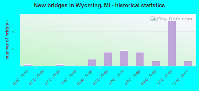
- New bridges - historical statistics
- 11910-1919
- 11930-1939
- 41950-1959
- 81960-1969
- 91970-1979
- 81980-1989
- 31990-1999
- 262000-2009
- 32010-2019
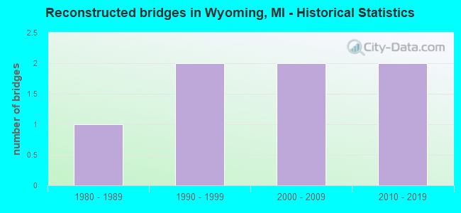
- Reconstructed bridges - Historical Statistics
- 11980-1989
- 21990-1999
- 22000-2009
- 22010-2019
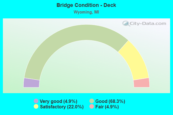
- Bridge Condition - Deck
- 4.9%Very good
- 68.3%Good
- 22.0%Satisfactory
- 4.9%Fair
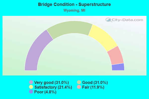
- Bridge Condition - Superstructure
- 31.0%Very good
- 31.0%Good
- 21.4%Satisfactory
- 11.9%Fair
- 4.8%Poor
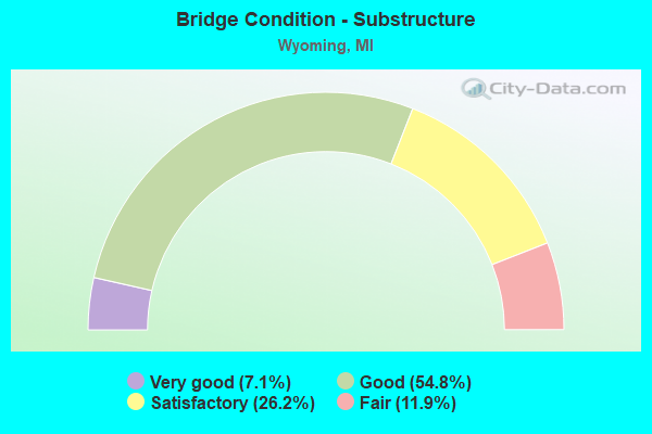
- Bridge Condition - Substructure
- 7.1%Very good
- 54.8%Good
- 26.2%Satisfactory
- 11.9%Fair
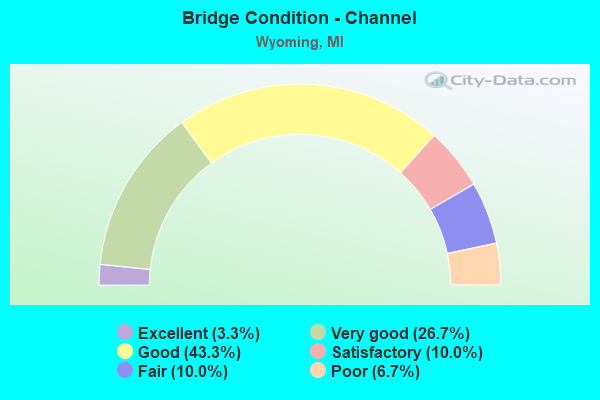
- Bridge Condition - Channel
- 3.3%Excellent
- 26.7%Very good
- 43.3%Good
- 10.0%Satisfactory
- 10.0%Fair
- 6.7%Poor
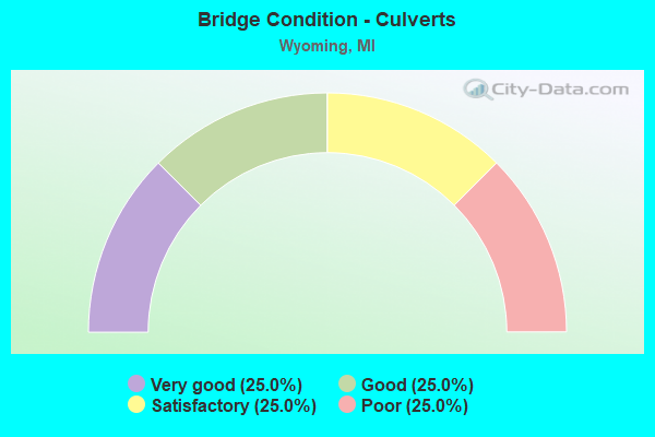
- Bridge Condition - Culverts
- 25.0%Very good
- 25.0%Good
- 25.0%Satisfactory
- 25.0%Poor
Find on map >> Show street view
Structure Number: 525, Location: 3 MI S OF THREE LAKES (Lat: 46.507017, Lng: -88.179814), Route carried "on" structure: County highway , Year Built: 1993, Status: Open, Structure Length: 1.22m (4.00ft), Average Daily Traffic: 28 (year 2015), Truck Traffic: 4%, Average Future Daily Traffic: 300 (year 2035), Design Load: HS 20, Features Intersected: SPRUCE RIVER, Facility Carried by Structure: FENCE LAKE ROAD
Minimum Vertical Clearance: 30+ m (98+ ft), Kilometerpoint: 1.259, Lanes on structure: 2, Owner: County Highway Agency, Approaching Roadway Width: 8.5m (27.9ft), Skew: 1 degrees, Material/Design: Prestressed concrete, Design/Construction: Box Beam or Girders - Multiple, Number Of Spans In Main Unit: 1, Length of Maximum Span: 10.6m (34.8ft), Curb-To-Curb Width: 8.2m (26.9ft), Out-to-Out Width: 8.5m (27.9ft)
Condition: Deck: Very good, Superstructure: Very good, Substructure: Good, Channel: Good, Operating Rating: 71.6 metric tons, Method Used To Determine Operating Rating: Load Factor (LF), Inventory Rating: 42.9 metric tons, Method Used To Determine Inventory Rating: Load Factor (LF), Structural Evaluation: Better than present minimum criteria, Deck Geometry: Equal to present minimum criteria, Waterway Adequacy: Better than present minimum criteria, Approach Roadway Alignment: Equal to present desirable criteria, Designated Inspection Frequency: Every 24 months, Inspection Date: September 2021, Deck Structure Type: Concrete Precast Panels, Wearing Surface/Protective System: Wearing Surface: Bituminous, Membrane: Other
Find on map >> Show street view
Structure Number: 4805, Location: IN WYOMING (Lat: 42.928786, Lng: -85.731844), Route carried "on" structure: Ramp Interstate 196, Year Built: 1965, Status: Open, Structure Length: 6.64m (21.78ft), Average Daily Traffic: 6,208 (year 2007), Truck Traffic: 11%, Average Future Daily Traffic: 6,782 (year 2018), Design Load: HS 20+Mod, Features Intersected: CSX RR
Minimum Vertical Clearance: 30.48m (100.00ft), Kilometerpoint: 0.478, Lanes on structure: 2, Owner: State Highway Agency, Approaching Roadway Width: 15.8m (51.8ft), Skew: 30 degrees, Material/Design: Prestressed concrete, Design/Construction: Stringer/Multi-beam, Number Of Spans In Main Unit: 4, Length of Maximum Span: 21.3m (69.9ft), Curb or Sidewalk Widths: Left: 0.1m (0.3ft), Right: 0.1m (0.3ft), Curb-To-Curb Width: 12.8m (42.0ft), Out-to-Out Width: 13.5m (44.3ft)
Condition: Deck: Satisfactory, Superstructure: Fair, Substructure: Fair, Operating Rating: 56.1 metric tons, Method Used To Determine Operating Rating: Load Factor (LF) rating reported by rating factor (RF) method using MS18 loading, Inventory Rating: 33.7 metric tons, Method Used To Determine Inventory Rating: Load Factor (LF) rating reported by rating factor (RF) method using MS18 loading, Structural Evaluation: Somewhat better than minimum adequacy, Deck Geometry: Superior to present desirable criteria, Approach Roadway Alignment: Better than present minimum criteria, Designated Inspection Frequency: Every 24 months, Inspection Date: June 2020, Deck Structure Type: Concrete Cast-file-Place, Wearing Surface/Protective System: Wearing Surface: Monolithic Concrete
Find on map >> Show street view
Structure Number: 4806, Location: IN WYOMING (Lat: 42.934431, Lng: -85.722958), Route carried "on" structure: Interstate 196, Year Built: 1963, Status: Open, Structure Length: 9.23m (30.28ft), Average Daily Traffic: 53,075 (year 2015), Truck Traffic: 8%, Average Future Daily Traffic: 61,650 (year 2035), Design Load: HS 20+Mod, Features Intersected: CONRAIL (NO TRACKS)(ABN)
Minimum Vertical Clearance: 30.48m (100.00ft), Kilometerpoint: 9.048, Lanes on structure: 2, Base Highway Network: Yes (Inventory Route: 40, Subroute: 5), Owner: State Highway Agency, Approaching Roadway Width: 12.8m (42.0ft), Skew: 6 degrees, Material/Design: Steel, Design/Construction: Stringer/Multi-beam, Number Of Spans In Main Unit: 3, Length of Maximum Span: 31.8m (104.3ft), Curb-To-Curb Width: 9.4m (30.8ft), Out-to-Out Width: 11.1m (36.4ft)
Condition: Deck: Satisfactory, Superstructure: Good, Substructure: Good, Operating Rating: 91.7 metric tons, Method Used To Determine Operating Rating: Load Factor (LF) rating reported by rating factor (RF) method using MS18 loading, Inventory Rating: 54.8 metric tons, Method Used To Determine Inventory Rating: Load Factor (LF) rating reported by rating factor (RF) method using MS18 loading, Structural Evaluation: Better than present minimum criteria, Deck Geometry: Meets minimum limits, Approach Roadway Alignment: Better than present minimum criteria, Designated Inspection Frequency: Every 24 months, Inspection Date: June 2020, Deck Structure Type: Concrete Cast-file-Place, Wearing Surface/Protective System: Wearing Surface: Monolithic Concrete
Find on map >> Show street view
Structure Number: 4807, Location: IN WYOMING (Lat: 42.934958, Lng: -85.722747), Route carried "on" structure: Interstate 196, Year Built: 1963, Year Reconstructed: 1998, Status: Open, Structure Length: 9.66m (31.69ft), Average Daily Traffic: 57,075 (year 2015), Truck Traffic: 8%, Average Future Daily Traffic: 61,650 (year 2035), Design Load: HS 20+Mod, Features Intersected: CONRAIL (NO TRACKS)(ABN)
Minimum Vertical Clearance: 30.48m (100.00ft), Kilometerpoint: 9.162, Lanes on structure: 2, Base Highway Network: Yes (Inventory Route: 40, Subroute: 9), Owner: State Highway Agency, Approaching Roadway Width: 12.8m (42.0ft), Skew: 6 degrees, Material/Design: Steel, Design/Construction: Stringer/Multi-beam, Number Of Spans In Main Unit: 3, Length of Maximum Span: 32.8m (107.6ft), Curb-To-Curb Width: 9.4m (30.8ft), Out-to-Out Width: 11.1m (36.4ft)
Condition: Deck: Satisfactory, Superstructure: Satisfactory, Substructure: Satisfactory, Operating Rating: 65.8 metric tons, Method Used To Determine Operating Rating: Load Factor (LF) rating reported by rating factor (RF) method using MS18 loading, Inventory Rating: 39.2 metric tons, Method Used To Determine Inventory Rating: Load Factor (LF) rating reported by rating factor (RF) method using MS18 loading, Structural Evaluation: Equal to present minimum criteria, Deck Geometry: Meets minimum limits, Approach Roadway Alignment: Better than present minimum criteria, Designated Inspection Frequency: Every 24 months, Inspection Date: June 2020, Deck Structure Type: Concrete Cast-file-Place, Wearing Surface/Protective System: Wearing Surface: Latex Concrete
Find on map >> Show street view
Structure Number: 4817, Location: IN WYOMING (I-196 EB) (Lat: 42.930611, Lng: -85.734094), Route carried "on" structure: ServiceState highway 21, Year Built: 1965, Status: Open, Structure Length: 4.87m (15.98ft), Average Daily Traffic: 6,208 (year 2007), Truck Traffic: 11%, Average Future Daily Traffic: 6,782 (year 2018), Design Load: HS 20+Mod, Features Intersected: I-196 EB
Minimum Vertical Clearance: 30.48m (100.00ft), Kilometerpoint: 0.401, Lanes on structure: 1, Lanes under structure: 2, Owner: State Highway Agency, Approaching Roadway Width: 9.1m (29.9ft), Skew: 3 degrees, Material/Design: Steel, Design/Construction: Stringer/Multi-beam, Number Of Spans In Main Unit: 3, Length of Maximum Span: 21.6m (70.9ft), Curb or Sidewalk Widths: Left: 0.1m (0.3ft), Right: 0.1m (0.3ft), Curb-To-Curb Width: 6.4m (21.0ft), Out-to-Out Width: 7.4m (24.3ft)
Condition: Deck: Good, Superstructure: Fair, Substructure: Fair, Operating Rating: 56.4 metric tons, Method Used To Determine Operating Rating: Load Factor (LF) rating reported by rating factor (RF) method using MS18 loading, Inventory Rating: 33.7 metric tons, Method Used To Determine Inventory Rating: Load Factor (LF) rating reported by rating factor (RF) method using MS18 loading, Structural Evaluation: Somewhat better than minimum adequacy, Deck Geometry: High priority of replacement, Underclear: Meets minimum limits, Approach Roadway Alignment: Better than present minimum criteria, Designated Inspection Frequency: Every 24 months, Inspection Date: August 2021, Bridge Improvement Cost: $59,000, Deck Structure Type: Concrete Cast-file-Place, Wearing Surface/Protective System: Wearing Surface: Monolithic Concrete
Find on map >> Show street view
Structure Number: 4818, Location: IN WYOMING (Lat: 42.927311, Lng: -85.730247), Route carried "on" structure: Ramp Interstate 196, Year Built: 1965, Status: Open, Structure Length: 4.36m (14.30ft), Average Daily Traffic: 6,208 (year 2007), Truck Traffic: 11%, Average Future Daily Traffic: 7,139 (year 2008), Design Load: HS 20+Mod, Features Intersected: M-21BR (CHICAGO DRIVE)
Minimum Vertical Clearance: 30.48m (100.00ft), Kilometerpoint: 0.682, Lanes on structure: 2, Lanes under structure: 5, Owner: State Highway Agency, Approaching Roadway Width: 9.1m (29.9ft), Material/Design: Prestressed concrete, Design/Construction: Stringer/Multi-beam, Number Of Spans In Main Unit: 3, Length of Maximum Span: 21.6m (70.9ft), Curb or Sidewalk Widths: Left: 0.1m (0.3ft), Right: 0.1m (0.3ft), Curb-To-Curb Width: 6.4m (21.0ft), Out-to-Out Width: 7.4m (24.3ft)
Condition: Deck: Good, Superstructure: Satisfactory, Substructure: Satisfactory, Operating Rating: 50.2 metric tons, Method Used To Determine Operating Rating: Load Factor (LF) rating reported by rating factor (RF) method using MS18 loading, Inventory Rating: 30.1 metric tons, Method Used To Determine Inventory Rating: Load Factor (LF) rating reported by rating factor (RF) method using MS18 loading, Structural Evaluation: Equal to present minimum criteria, Deck Geometry: High priority of replacement, Underclear: Better than present minimum criteria, Approach Roadway Alignment: Equal to present desirable criteria, Designated Inspection Frequency: Every 24 months, Inspection Date: June 2020, Deck Structure Type: Concrete Cast-file-Place, Wearing Surface/Protective System: Wearing Surface: Monolithic Concrete
Find on map >> Show street view
Structure Number: 4835, Location: W LTS OF WYOMING (Lat: 42.877419, Lng: -85.782272), Route carried "on" structure: City street 2001, Year Built: 1972, Year Reconstructed: 2013, Status: Open, Structure Length: 10.79m (35.40ft), Average Daily Traffic: 5,443 (year 1997), Truck Traffic: 1%, Average Future Daily Traffic: 250 (year 1977), Design Load: H 20, Features Intersected: I-196, Facility Carried by Structure: KENOWA AVE
Minimum Vertical Clearance: 30.48m (100.00ft), Kilometerpoint: 7.210, Lanes on structure: 2, Lanes under structure: 4, Owner: State Highway Agency, Approaching Roadway Width: 13.4m (44.0ft), Skew: 4 degrees, Material/Design: Steel, Design/Construction: Stringer/Multi-beam, Number Of Spans In Main Unit: 4, Length of Maximum Span: 36.9m (121.1ft), Curb-To-Curb Width: 12.3m (40.4ft), Out-to-Out Width: 13.5m (44.3ft)
Condition: Deck: Good, Superstructure: Good, Substructure: Satisfactory, Operating Rating: 71.0 metric tons, Method Used To Determine Operating Rating: Load Factor (LF) rating reported by rating factor (RF) method using MS18 loading, Inventory Rating: 42.4 metric tons, Method Used To Determine Inventory Rating: Load Factor (LF) rating reported by rating factor (RF) method using MS18 loading, Structural Evaluation: Equal to present minimum criteria, Deck Geometry: Somewhat better than minimum adequacy, Underclear: Somewhat better than minimum adequacy, Approach Roadway Alignment: Better than present minimum criteria, Designated Inspection Frequency: Every 24 months, Inspection Date: August 2020, Deck Structure Type: Concrete Cast-file-Place, Wearing Surface/Protective System: Wearing Surface: Latex Concrete
Find on map >> Show street view
Structure Number: 4853, Location: IN WYOMING (Lat: 42.935819, Lng: -85.687592), Route carried "on" structure: Business State highway 21, Year Built: 1916, Status: Open, Structure Length: 1.82m (5.97ft), Average Daily Traffic: 16,531 (year 2007), Truck Traffic: 10%, Average Future Daily Traffic: 18,421 (year 2018), Design Load: H 20, Features Intersected: PLASTER CREEK
Minimum Vertical Clearance: 30.48m (100.00ft), Kilometerpoint: 8.766, Lanes on structure: 3, Owner: State Highway Agency, Approaching Roadway Width: 13.1m (43.0ft), Material/Design: Concrete, Design/Construction: Arch - Deck, Number Of Spans In Main Unit: 1, Length of Maximum Span: 18.2m (59.7ft), Curb or Sidewalk Widths: Left: 3.3m (10.8ft), Right: 3.3m (10.8ft), Curb-To-Curb Width: 12.8m (42.0ft), Out-to-Out Width: 20.1m (65.9ft)
Condition: Superstructure: Satisfactory, Substructure: Satisfactory, Channel: Good, Operating Rating: 89.4 metric tons, Method Used To Determine Operating Rating: Load Factor (LF) rating reported by rating factor (RF) method using MS18 loading, Inventory Rating: 53.5 metric tons, Method Used To Determine Inventory Rating: Load Factor (LF) rating reported by rating factor (RF) method using MS18 loading, Structural Evaluation: Equal to present minimum criteria, Deck Geometry: Meets minimum limits, Waterway Adequacy: Equal to present desirable criteria, Approach Roadway Alignment: Better than present minimum criteria, Designated Inspection Frequency: Every 24 months, Inspection Date: August 2020
Find on map >> Show street view
Structure Number: 4866, Location: IN WYOMING (Lat: 42.913217, Lng: -85.675897), Route carried "on" structure: State highway 11, Year Built: 1937, Year Reconstructed: 1998, Status: Open, Structure Length: 5.18m (16.99ft), Average Daily Traffic: 37,247 (year 2007), Truck Traffic: 4%, Average Future Daily Traffic: 50,591 (year 2018), Design Load: HS 20, Features Intersected: CONRAIL
Minimum Vertical Clearance: 30.48m (100.00ft), Kilometerpoint: 18.128, Lanes on structure: 4, Base Highway Network: Yes (Inventory Route: 40, Subroute: 8), Owner: State Highway Agency, Approaching Roadway Width: 18.9m (62.0ft), Skew: 21 degrees, Material/Design: Steel, Design/Construction: Stringer/Multi-beam, Number Of Spans In Main Unit: 3, Length of Maximum Span: 18.2m (59.7ft), Curb or Sidewalk Widths: Left: 1.5m (4.9ft), Right: 1.5m (4.9ft), Curb-To-Curb Width: 19.2m (63.0ft), Out-to-Out Width: 22.9m (75.1ft)
Condition: Deck: Satisfactory, Superstructure: Fair, Substructure: Fair, Operating Rating: 97.2 metric tons, Method Used To Determine Operating Rating: Load Factor (LF) rating reported by rating factor (RF) method using MS18 loading, Inventory Rating: 64.5 metric tons, Method Used To Determine Inventory Rating: Load Factor (LF) rating reported by rating factor (RF) method using MS18 loading, Structural Evaluation: Somewhat better than minimum adequacy, Deck Geometry: Equal to present minimum criteria, Underclear: Equal to present minimum criteria, Approach Roadway Alignment: Better than present minimum criteria, Designated Inspection Frequency: Every 24 months, Inspection Date: October 2020, Deck Structure Type: Concrete Cast-file-Place, Wearing Surface/Protective System: Wearing Surface: Monolithic Concrete, Deck Protection: Epoxy Coated Reinforcing
Find on map >> Show street view
Structure Number: 4941, Location: IN WYOMING (Lat: 42.868417, Lng: -85.679769), Route carried "on" structure: US 131, Year Built: 2000, Status: Open, Structure Length: 1.70m (5.58ft), Average Daily Traffic: 38,681 (year 2007), Truck Traffic: 8%, Average Future Daily Traffic: 39,400 (year 2015), Design Load: HS 25 or greater, Features Intersected: BUCK CREEK
Minimum Vertical Clearance: 30.48m (100.00ft), Kilometerpoint: 0.282, Lanes on structure: 3, Base Highway Network: Yes (Inventory Route: 41, Subroute: 10), Owner: State Highway Agency, Approaching Roadway Width: 12.8m (42.0ft), Skew: 10 degrees, Material/Design: Prestressed concrete, Design/Construction: Box Beam or Girders - Single/Spread, Number Of Spans In Main Unit: 1, Length of Maximum Span: 15.5m (50.9ft), Curb-To-Curb Width: 24.6m (80.7ft), Out-to-Out Width: 25.1m (82.3ft)
Condition: Deck: Good, Superstructure: Very good, Substructure: Good, Channel: Very good, Operating Rating: 57.6 metric tons, Method Used To Determine Operating Rating: Load Factor (LF), Inventory Rating: 30.9 metric tons, Method Used To Determine Inventory Rating: Load Factor (LF), Structural Evaluation: Better than present minimum criteria, Deck Geometry: Superior to present desirable criteria, Waterway Adequacy: Equal to present desirable criteria, Approach Roadway Alignment: Better than present minimum criteria, Designated Inspection Frequency: Every 24 months, Inspection Date: September 2020, Deck Structure Type: Concrete Cast-file-Place, Wearing Surface/Protective System: Wearing Surface: Integral Concrete, Deck Protection: Epoxy Coated Reinforcing
Find on map >> Show street view
Structure Number: 4942, Location: IN WYOMING (Lat: 42.868350, Lng: -85.680144), Route carried "on" structure: US 131, Year Built: 2000, Status: Open, Structure Length: 1.71m (5.61ft), Average Daily Traffic: 38,681 (year 2007), Truck Traffic: 8%, Average Future Daily Traffic: 43,973 (year 2018), Design Load: HS 25 or greater, Features Intersected: BUCK CREEK
Minimum Vertical Clearance: 30.48m (100.00ft), Kilometerpoint: 11.287, Lanes on structure: 2, Base Highway Network: Yes (Inventory Route: 41, Subroute: 7), Owner: State Highway Agency, Approaching Roadway Width: 12.8m (42.0ft), Skew: 10 degrees, Material/Design: Prestressed concrete, Design/Construction: Box Beam or Girders - Single/Spread, Number Of Spans In Main Unit: 1, Length of Maximum Span: 17.1m (56.1ft), Curb-To-Curb Width: 20.7m (67.9ft), Out-to-Out Width: 24.1m (79.1ft)
Condition: Deck: Good, Superstructure: Very good, Substructure: Good, Channel: Very good, Operating Rating: 89.7 metric tons, Method Used To Determine Operating Rating: Load Factor (LF) rating reported by rating factor (RF) method using MS18 loading, Inventory Rating: 48.3 metric tons, Method Used To Determine Inventory Rating: Load Factor (LF) rating reported by rating factor (RF) method using MS18 loading, Structural Evaluation: Better than present minimum criteria, Deck Geometry: Superior to present desirable criteria, Waterway Adequacy: Equal to present desirable criteria, Approach Roadway Alignment: Better than present minimum criteria, Designated Inspection Frequency: Every 24 months, Inspection Date: September 2020, Deck Structure Type: Concrete Cast-file-Place, Wearing Surface/Protective System: Wearing Surface: Monolithic Concrete, Deck Protection: Epoxy Coated Reinforcing
Find on map >> Show street view
Structure Number: 4943, Location: IN WYOMING @ 54 TH (Lat: 42.868181, Lng: -85.681058), Route carried "on" structure: Ramp US 131, Year Built: 1985, Status: Open, Structure Length: 4.97m (16.31ft), Average Daily Traffic: 3,000 (year 1988), Truck Traffic: 3%, Average Future Daily Traffic: 3,450 (year 2008), Design Load: HS 25 or greater, Features Intersected: BUCK CREEK
Minimum Vertical Clearance: 30.48m (100.00ft), Kilometerpoint: 0.277, Lanes on structure: 1, Owner: State Highway Agency, Approaching Roadway Width: 9.1m (29.9ft), Skew: 4 degrees, Material/Design: Steel continuous, Design/Construction: Stringer/Multi-beam, Number Of Spans In Main Unit: 2, Length of Maximum Span: 32.9m (107.9ft), Curb-To-Curb Width: 7.9m (25.9ft), Out-to-Out Width: 8.9m (29.2ft)
Condition: Deck: Good, Superstructure: Good, Substructure: Good, Channel: Good, Operating Rating: 62.9 metric tons, Method Used To Determine Operating Rating: Load Factor (LF) rating reported by rating factor (RF) method using MS18 loading, Inventory Rating: 37.6 metric tons, Method Used To Determine Inventory Rating: Load Factor (LF) rating reported by rating factor (RF) method using MS18 loading, Structural Evaluation: Better than present minimum criteria, Deck Geometry: Equal to present desirable criteria, Waterway Adequacy: Equal to present desirable criteria, Approach Roadway Alignment: Equal to present desirable criteria, Designated Inspection Frequency: Every 24 months, Inspection Date: September 2020, Deck Structure Type: Concrete Cast-file-Place, Wearing Surface/Protective System: Wearing Surface: Latex Concrete, Deck Protection: Epoxy Coated Reinforcing
Find on map >> Show street view
Structure Number: 4966, Location: IN WYOMING (Lat: 42.866039, Lng: -85.679456), Route carried "on" structure: City street 2001, Year Built: 1985, Status: Open, Structure Length: 6.12m (20.08ft), Average Daily Traffic: 34,000 (year 2013), Truck Traffic: 4%, Average Future Daily Traffic: 39,100 (year 2033), Design Load: HS 20, Features Intersected: US-131, Facility Carried by Structure: 54TH ST
Minimum Vertical Clearance: 30.48m (100.00ft), Kilometerpoint: 0.362, Lanes on structure: 4, Lanes under structure: 8, Base Highway Network: Yes (Inventory Route: 41, Subroute: 9), Owner: State Highway Agency, Approaching Roadway Width: 10.3m (33.8ft), Skew: 30 degrees, Material/Design: Steel continuous, Design/Construction: Stringer/Multi-beam, Number Of Spans In Main Unit: 2, Length of Maximum Span: 31.4m (103.0ft), Curb or Sidewalk Widths: Left: 2.1m (6.9ft), Right: 2.1m (6.9ft), Curb-To-Curb Width: 17.4m (57.1ft), Out-to-Out Width: 26.9m (88.3ft)
Condition: Deck: Satisfactory, Superstructure: Fair, Substructure: Satisfactory, Operating Rating: 42.8 metric tons, Method Used To Determine Operating Rating: Load and Resistance Factor Rating (LRFR) rating reported by rating factor(RF) method using HL-93 loadings, Inventory Rating: 33.0 metric tons, Method Used To Determine Inventory Rating: Load and Resistance Factor Rating (LRFR) rating reported by rating factor(RF) method using HL-93 loadings, Structural Evaluation: Somewhat better than minimum adequacy, Deck Geometry: Somewhat better than minimum adequacy, Underclear: High priority of corrective action, Approach Roadway Alignment: Better than present minimum criteria, Designated Inspection Frequency: Every 24 months, Inspection Date: June 2021, Deck Structure Type: Concrete Cast-file-Place, Wearing Surface/Protective System: Wearing Surface: Epoxy Overlay, Deck Protection: Epoxy Coated Reinforcing
Find on map >> Show street view
Structure Number: 4967, Location: IN WYOMING (Lat: 42.884192, Lng: -85.680617), Route carried "on" structure: City street 2001, Year Built: 2008, Status: Open, Structure Length: 4.16m (13.65ft), Average Daily Traffic: 50,697 (year 1997), Truck Traffic: 5%, Average Future Daily Traffic: 60,000 (year 2020), Design Load: HL 93, Features Intersected: US-131, Facility Carried by Structure: 44TH ST
Minimum Vertical Clearance: 30.48m (100.00ft), Kilometerpoint: 0.055, Lanes on structure: 6, Lanes under structure: 6, Base Highway Network: Yes (Inventory Route: 341, Subroute: 10), Owner: State Highway Agency, Approaching Roadway Width: 30.4m (99.7ft), Skew: 1 degrees, Material/Design: Steel continuous, Design/Construction: Stringer/Multi-beam, Number Of Spans In Main Unit: 2, Length of Maximum Span: 20.1m (65.9ft), Curb or Sidewalk Widths: Left: 2.4m (7.9ft), Right: 0.0m, Curb-To-Curb Width: 33.4m (109.6ft), Out-to-Out Width: 36.6m (120.1ft)
Condition: Deck: Good, Superstructure: Very good, Substructure: Very good, Operating Rating: 61.5 metric tons, Method Used To Determine Operating Rating: Load Factor (LF), Inventory Rating: 38.9 metric tons, Method Used To Determine Inventory Rating: Load Factor (LF), Structural Evaluation: Equal to present desirable criteria, Deck Geometry: Superior to present desirable criteria, Underclear: High priority of corrective action, Approach Roadway Alignment: Equal to present desirable criteria, Designated Inspection Frequency: Every 24 months, Inspection Date: July 2020, Deck Structure Type: Concrete Cast-file-Place, Wearing Surface/Protective System: Wearing Surface: Monolithic Concrete, Deck Protection: Epoxy Coated Reinforcing
Find on map >> Show street view
Structure Number: 4968, Location: IN WYOMING (Lat: 42.898717, Lng: -85.677778), Route carried "on" structure: City street 2001, Year Built: 2011, Status: Open, Structure Length: 4.28m (14.04ft), Average Daily Traffic: 32,736 (year 1997), Truck Traffic: 1%, Average Future Daily Traffic: 28,000 (year 2031), Design Load: HL 93, Features Intersected: US-131, Facility Carried by Structure: 36TH ST
Minimum Vertical Clearance: 30.48m (100.00ft), Kilometerpoint: 4.606, Lanes on structure: 6, Lanes under structure: 6, Owner: State Highway Agency, Approaching Roadway Width: 21.6m (70.9ft), Material/Design: Prestressed concrete, Design/Construction: Box Beam or Girders - Single/Spread, Number Of Spans In Main Unit: 2, Length of Maximum Span: 20.8m (68.2ft), Curb or Sidewalk Widths: Left: 2.4m (7.9ft), Right: 2.4m (7.9ft), Curb-To-Curb Width: 21.3m (69.9ft), Out-to-Out Width: 27.2m (89.2ft)
Condition: Deck: Good, Superstructure: Satisfactory, Substructure: Good, Operating Rating: 64.5 metric tons, Method Used To Determine Operating Rating: Load and Resistance Factor Rating (LRFR) rating reported by rating factor(RF) method using HL-93 loadings, Inventory Rating: 44.4 metric tons, Method Used To Determine Inventory Rating: Load and Resistance Factor Rating (LRFR) rating reported by rating factor(RF) method using HL-93 loadings, Structural Evaluation: Equal to present minimum criteria, Deck Geometry: High priority of replacement, Underclear: Meets minimum limits, Approach Roadway Alignment: Equal to present desirable criteria, Designated Inspection Frequency: Every 24 months, Inspection Date: June 2021, Deck Structure Type: Concrete Cast-file-Place, Wearing Surface/Protective System: Wearing Surface: Monolithic Concrete, Deck Protection: Epoxy Coated Reinforcing
Find on map >> Show street view
Structure Number: 4969, Location: IN WYOMING (Lat: 42.905983, Lng: -85.676983), Route carried "on" structure: City street 2001, Year Built: 1958, Year Reconstructed: 1993, Status: Open, Structure Length: 6.49m (21.29ft), Average Daily Traffic: 16,925 (year 1997), Truck Traffic: 1%, Average Future Daily Traffic: 25,000 (year 2020), Design Load: HS 20, Features Intersected: US-131, Facility Carried by Structure: 32ND ST
Minimum Vertical Clearance: 30.48m (100.00ft), Kilometerpoint: 1.485, Lanes on structure: 2, Lanes under structure: 4, Owner: State Highway Agency, Approaching Roadway Width: 10.9m (35.8ft), Material/Design: Prestressed concrete, Design/Construction: Box Beam or Girders - Multiple, Number Of Spans In Main Unit: 4, Length of Maximum Span: 18.2m (59.7ft), Curb or Sidewalk Widths: Left: 1.6m (5.2ft), Right: 1.6m (5.2ft), Curb-To-Curb Width: 14.6m (47.9ft), Out-to-Out Width: 18.7m (61.4ft)
Condition: Deck: Satisfactory, Superstructure: Satisfactory, Substructure: Fair, Operating Rating: 68.7 metric tons, Method Used To Determine Operating Rating: Load Factor (LF) rating reported by rating factor (RF) method using MS18 loading, Inventory Rating: 36.0 metric tons, Method Used To Determine Inventory Rating: Load Factor (LF) rating reported by rating factor (RF) method using MS18 loading, Structural Evaluation: Somewhat better than minimum adequacy, Deck Geometry: Superior to present desirable criteria, Underclear: High priority of corrective action, Approach Roadway Alignment: Better than present minimum criteria, Designated Inspection Frequency: Every 24 months, Inspection Date: September 2020, Deck Structure Type: Concrete Cast-file-Place, Wearing Surface/Protective System: Wearing Surface: Monolithic Concrete, Deck Protection: Epoxy Coated Reinforcing
Find on map >> Show street view
Structure Number: 497, Location: IN WYOMING (Lat: 42.913253, Lng: -85.677533), Route carried "on" structure: State highway 11, Year Built: 2004, Status: Open, Structure Length: 4.66m (15.29ft), Average Daily Traffic: 44,816 (year 2007), Truck Traffic: 4%, Average Future Daily Traffic: 50,591 (year 2018), Design Load: HS 25 or greater, Features Intersected: US-131
Minimum Vertical Clearance: 30.48m (100.00ft), Kilometerpoint: 18.000, Lanes on structure: 5, Lanes under structure: 5, Base Highway Network: Yes (Inventory Route: 40, Subroute: 8), Owner: State Highway Agency, Approaching Roadway Width: 17.0m (55.8ft), Skew: 21 degrees, Material/Design: Prestressed concrete, Design/Construction: Box Beam or Girders - Single/Spread, Number Of Spans In Main Unit: 2, Length of Maximum Span: 23.3m (76.4ft), Curb or Sidewalk Widths: Left: 2.4m (7.9ft), Right: 0.0m, Curb-To-Curb Width: 25.1m (82.3ft), Out-to-Out Width: 28.6m (93.8ft)
Condition: Deck: Good, Superstructure: Satisfactory, Substructure: Good, Operating Rating: 98.4 metric tons, Method Used To Determine Operating Rating: Load Factor (LF), Inventory Rating: 45.5 metric tons, Method Used To Determine Inventory Rating: Load Factor (LF), Structural Evaluation: Equal to present minimum criteria, Deck Geometry: Superior to present desirable criteria, Underclear: Meets minimum limits, Approach Roadway Alignment: Better than present minimum criteria, Designated Inspection Frequency: Every 24 months, Inspection Date: August 2021, Deck Structure Type: Concrete Cast-file-Place, Wearing Surface/Protective System: Wearing Surface: Monolithic Concrete, Deck Protection: Epoxy Coated Reinforcing
Find on map >> Show street view
Structure Number: 5125, Location: 0.20 MI S OF 60TH ST (Lat: 42.853381, Lng: -85.782175), Route carried "on" structure: County highway , Year Built: 2010, Status: Open, Structure Length: 0.67m (2.20ft), Average Daily Traffic: 2,704 (year 2003), Average Future Daily Traffic: 4,600 (year 2023), Design Load: HS 20+Mod, Features Intersected: RUSH CREEK, Facility Carried by Structure: KENOWA AVE
Minimum Vertical Clearance: 30.48m (100.00ft), Kilometerpoint: 4.579, Lanes on structure: 2, Owner: County Highway Agency, Approaching Roadway Width: 6.1m (20.0ft), Material/Design: Concrete, Design/Construction: Culvert, Number Of Spans In Main Unit: 1, Length of Maximum Span: 6.1m (20.0ft), Curb-To-Curb Width: 6.1m (20.0ft), Out-to-Out Width: 34.1m (111.9ft)
Condition: Channel: Very good, Culverts: Good, Operating Rating: 51.5 metric tons, Method Used To Determine Operating Rating: Load and Resistance Factor Rating (LRFR) rating reported by rating factor(RF) method using HL-93 loadings, Inventory Rating: 39.9 metric tons, Method Used To Determine Inventory Rating: Load and Resistance Factor Rating (LRFR) rating reported by rating factor(RF) method using HL-93 loadings, Structural Evaluation: Better than present minimum criteria, Deck Geometry: High priority of replacement, Waterway Adequacy: Equal to present desirable criteria, Approach Roadway Alignment: Equal to present desirable criteria, Designated Inspection Frequency: Every 24 months, Inspection Date: October 2021
Find on map >> Show street view
Structure Number: 5242, Location: IN WYOMING (Lat: 42.890833, Lng: -85.724331), Route carried "on" structure: City street 2001, Year Built: 1986, Status: Open, Structure Length: 2.04m (6.69ft), Average Daily Traffic: 21,839 (year 2009), Truck Traffic: 7%, Average Future Daily Traffic: 29,414 (year 2029), Design Load: HS 20, Features Intersected: BUCK CREEK, Facility Carried by Structure: BYRON CENTER AVE
Minimum Vertical Clearance: 30.48m (100.00ft), Kilometerpoint: 13.622, Lanes on structure: 4, Owner: City or Municipal Highway Agency, Approaching Roadway Width: 14.6m (47.9ft), Material/Design: Concrete, Design/Construction: Culvert, Number Of Spans In Main Unit: 2, Length of Maximum Span: 9.7m (31.8ft), Curb or Sidewalk Widths: Left: 1.5m (4.9ft), Right: 1.5m (4.9ft), Curb-To-Curb Width: 14.6m (47.9ft), Out-to-Out Width: 28.0m (91.9ft)
Condition: Channel: Fair, Culverts: Very good, Operating Rating: 43.4 metric tons, Method Used To Determine Operating Rating: Field evaluation and documented engineering judgment, Inventory Rating: 32.7 metric tons, Method Used To Determine Inventory Rating: Field evaluation and documented engineering judgment, Structural Evaluation: Equal to present desirable criteria, Deck Geometry: High priority of replacement, Waterway Adequacy: Equal to present minimum criteria, Approach Roadway Alignment: Equal to present desirable criteria, Designated Inspection Frequency: Every 24 months, Inspection Date: September 2020, Wearing Surface/Protective System: Wearing Surface: Bituminous
Find on map >> Show street view
Structure Number: 5245, Location: 200 FT N OF 56TH ST (Lat: 42.863700, Lng: -85.676053), Route carried "on" structure: City street , Year Built: 2000, Status: Open, Structure Length: 2.00m (6.56ft), Average Daily Traffic: 6,793 (year 2009), Truck Traffic: 9%, Average Future Daily Traffic: 9,149 (year 2029), Design Load: HS 20+Mod, Features Intersected: BUCK CREEK, Facility Carried by Structure: CLAY AVE
Minimum Vertical Clearance: 30.48m (100.00ft), Kilometerpoint: 0.959, Lanes on structure: 2, Owner: City or Municipal Highway Agency, Approaching Roadway Width: 7.3m (24.0ft), Skew: 1 degrees, Material/Design: Prestressed concrete, Design/Construction: Box Beam or Girders - Multiple, Number Of Spans In Main Unit: 1, Length of Maximum Span: 20.0m (65.6ft), Curb or Sidewalk Widths: Left: 2.7m (8.9ft), Right: 2.7m (8.9ft), Curb-To-Curb Width: 11.6m (38.1ft), Out-to-Out Width: 17.7m (58.1ft)
Condition: Deck: Good, Superstructure: Fair, Substructure: Good, Channel: Good, Operating Rating: 97.2 metric tons, Method Used To Determine Operating Rating: Load Factor (LF) rating reported by rating factor (RF) method using MS18 loading, Inventory Rating: 78.4 metric tons, Method Used To Determine Inventory Rating: Load Factor (LF) rating reported by rating factor (RF) method using MS18 loading, Structural Evaluation: Somewhat better than minimum adequacy, Deck Geometry: Somewhat better than minimum adequacy, Waterway Adequacy: Equal to present desirable criteria, Approach Roadway Alignment: Better than present minimum criteria, Designated Inspection Frequency: Every 24 months, Inspection Date: September 2020, Deck Structure Type: Concrete Cast-file-Place, Wearing Surface/Protective System: Wearing Surface: Monolithic Concrete, Deck Protection: Epoxy Coated Reinforcing
Find on map >> Show street view
Structure Number: 5246, Location: 200 FT S OF 44TH ST (Lat: 42.883703, Lng: -85.705339), Route carried "on" structure: City street 2001, Year Built: 1979, Year Reconstructed: 2013, Status: Open, Structure Length: 2.10m (6.89ft), Average Daily Traffic: 12,559 (year 2009), Truck Traffic: 1%, Average Future Daily Traffic: 16,915 (year 2029), Design Load: HS 20+Mod, Features Intersected: BUCK CREEK, Facility Carried by Structure: BURLINGAME AVE
Minimum Vertical Clearance: 30.48m (100.00ft), Kilometerpoint: 12.845, Lanes on structure: 4, Owner: City or Municipal Highway Agency, Approaching Roadway Width: 19.8m (65.0ft), Skew: 2 degrees, Material/Design: Prestressed concrete, Design/Construction: Box Beam or Girders - Multiple, Number Of Spans In Main Unit: 1, Length of Maximum Span: 20.6m (67.6ft), Curb or Sidewalk Widths: Left: 2.5m (8.2ft), Right: 2.5m (8.2ft), Curb-To-Curb Width: 18.3m (60.0ft), Out-to-Out Width: 25.1m (82.3ft)
Condition: Deck: Good, Superstructure: Very good, Substructure: Good, Channel: Good, Operating Rating: 97.2 metric tons, Method Used To Determine Operating Rating: Load and Resistance Factor Rating (LRFR) rating reported by rating factor(RF) method using HL-93 loadings, Inventory Rating: 80.7 metric tons, Method Used To Determine Inventory Rating: Load and Resistance Factor Rating (LRFR) rating reported by rating factor(RF) method using HL-93 loadings, Structural Evaluation: Better than present minimum criteria, Deck Geometry: Somewhat better than minimum adequacy, Waterway Adequacy: Equal to present desirable criteria, Approach Roadway Alignment: Better than present minimum criteria, Designated Inspection Frequency: Every 24 months, Inspection Date: September 2020, Deck Structure Type: Concrete Cast-file-Place, Wearing Surface/Protective System: Wearing Surface: Monolithic Concrete, Deck Protection: Epoxy Coated Reinforcing
Find on map >> Show street view
Structure Number: 5247, Location: IN WYOMING (Lat: 42.937575, Lng: -85.690156), Route carried "on" structure: City street 2001, Year Built: 1956, Status: Open, Structure Length: 1.87m (6.14ft), Average Daily Traffic: 5,129 (year 2008), Truck Traffic: 9%, Average Future Daily Traffic: 6,908 (year 2028), Design Load: HS 20+Mod, Features Intersected: PLASTER CREEK, Facility Carried by Structure: GODFREY AVENUE
Minimum Vertical Clearance: 30.48m (100.00ft), Kilometerpoint: 1.225, Lanes on structure: 4, Owner: City or Municipal Highway Agency, Approaching Roadway Width: 12.8m (42.0ft), Skew: 2 degrees, Material/Design: Steel, Design/Construction: Stringer/Multi-beam, Number Of Spans In Main Unit: 1, Length of Maximum Span: 17.7m (58.1ft), Curb or Sidewalk Widths: Left: 1.5m (4.9ft), Right: 1.5m (4.9ft), Curb-To-Curb Width: 13.7m (44.9ft), Out-to-Out Width: 17.2m (56.4ft)
Condition: Deck: Fair, Superstructure: Poor, Substructure: Fair, Channel: Poor, Operating Rating: 58.6 metric tons, Method Used To Determine Operating Rating: Load Factor (LF) rating reported by rating factor (RF) method using MS18 loading, Inventory Rating: 35.0 metric tons, Method Used To Determine Inventory Rating: Load Factor (LF) rating reported by rating factor (RF) method using MS18 loading, Structural Evaluation: Meets minimum limits, Deck Geometry: High priority of replacement, Waterway Adequacy: Equal to present minimum criteria, Approach Roadway Alignment: Equal to present desirable criteria, Length Of Structure Improvement: 2.07m (6.79ft), Designated Inspection Frequency: Every 24 months, Inspection Date: September 2020, Bridge Improvement Cost: $210,000, Roadway Improvement Cost: $30,000, Total Project Cost: $240,000, Deck Structure Type: Concrete Cast-file-Place, Wearing Surface/Protective System: Wearing Surface: Bituminous
Find on map >> Show street view
Structure Number: 5248, Location: IN WYOMING (Lat: 42.870644, Lng: -85.684039), Route carried "on" structure: City street 2001, Year Built: 1990, Status: Open, Structure Length: 1.89m (6.20ft), Average Daily Traffic: 14,442 (year 2009), Truck Traffic: 11%, Average Future Daily Traffic: 19,451 (year 2029), Design Load: HS 20, Features Intersected: BUCK CREEK, Facility Carried by Structure: CLYDE PARK AVENUE
Minimum Vertical Clearance: 30.48m (100.00ft), Kilometerpoint: 11.380, Lanes on structure: 2, Owner: City or Municipal Highway Agency, Approaching Roadway Width: 15.9m (52.2ft), Skew: 20 degrees, Material/Design: Prestressed concrete, Design/Construction: Box Beam or Girders - Multiple, Number Of Spans In Main Unit: 1, Length of Maximum Span: 18.9m (62.0ft), Curb or Sidewalk Widths: Left: 2.1m (6.9ft), Right: 2.1m (6.9ft), Curb-To-Curb Width: 15.9m (52.2ft), Out-to-Out Width: 27.1m (88.9ft)
Condition: Deck: Satisfactory, Superstructure: Good, Substructure: Satisfactory, Channel: Good, Operating Rating: 63.9 metric tons, Method Used To Determine Operating Rating: Load Factor (LF), Inventory Rating: 38.3 metric tons, Method Used To Determine Inventory Rating: Load Factor (LF), Structural Evaluation: Equal to present minimum criteria, Deck Geometry: Superior to present desirable criteria, Waterway Adequacy: Equal to present desirable criteria, Approach Roadway Alignment: Equal to present desirable criteria, Designated Inspection Frequency: Every 24 months, Inspection Date: September 2020, Deck Structure Type: Concrete Cast-file-Place, Wearing Surface/Protective System: Wearing Surface: Monolithic Concrete, Deck Protection: Epoxy Coated Reinforcing
Find on map >> Show street view
Structure Number: 5249, Location: IN WYOMING AND GRAND RAPI (Lat: 42.929097, Lng: -85.686292), Route carried "on" structure: City street 2001, Year Built: 1994, Status: Open, Structure Length: 2.25m (7.38ft), Average Daily Traffic: 18,084 (year 2009), Truck Traffic: 10%, Average Future Daily Traffic: 24,357 (year 2029), Design Load: HS 25 or greater, Features Intersected: PLASTER CREEK, Facility Carried by Structure: CLYDE PARK AVENUE
Minimum Vertical Clearance: 30.48m (100.00ft), Kilometerpoint: 17.876, Lanes on structure: 2, Owner: City or Municipal Highway Agency, Approaching Roadway Width: 13.4m (44.0ft), Skew: 1 degrees, Material/Design: Prestressed concrete, Design/Construction: Box Beam or Girders - Multiple, Number Of Spans In Main Unit: 1, Length of Maximum Span: 22.5m (73.8ft), Curb or Sidewalk Widths: Left: 2.4m (7.9ft), Right: 3.7m (12.1ft), Curb-To-Curb Width: 13.4m (44.0ft), Out-to-Out Width: 20.1m (65.9ft)
Condition: Deck: Good, Superstructure: Good, Substructure: Good, Channel: Good, Inventory Rating: 62.3 metric tons, Method Used To Determine Inventory Rating: Load Factor (LF), Structural Evaluation: Better than present minimum criteria, Deck Geometry: Equal to present minimum criteria, Waterway Adequacy: Equal to present desirable criteria, Approach Roadway Alignment: Equal to present desirable criteria, Designated Inspection Frequency: Every 24 months, Inspection Date: September 2020, Deck Structure Type: Concrete Cast-file-Place, Wearing Surface/Protective System: Wearing Surface: Monolithic Concrete, Deck Protection: Epoxy Coated Reinforcing
Find on map >> Show street view
Structure Number: 525, Location: IN WYOMING (Lat: 42.918344, Lng: -85.671150), Route carried "on" structure: City street 2001, Year Built: 1958, Status: Open, Structure Length: 1.85m (6.07ft), Average Daily Traffic: 12,915 (year 2009), Truck Traffic: 9%, Average Future Daily Traffic: 17,395 (year 2029), Design Load: HS 20+Mod, Features Intersected: PLASTER CREEK, Facility Carried by Structure: BUCHANAN AVENUE
Minimum Vertical Clearance: 30.48m (100.00ft), Kilometerpoint: 4.263, Lanes on structure: 4, Owner: City or Municipal Highway Agency, Approaching Roadway Width: 13.4m (44.0ft), Skew: 2 degrees, Material/Design: Prestressed concrete, Design/Construction: Box Beam or Girders - Multiple, Number Of Spans In Main Unit: 1, Length of Maximum Span: 17.5m (57.4ft), Curb or Sidewalk Widths: Left: 1.5m (4.9ft), Right: 1.5m (4.9ft), Curb-To-Curb Width: 13.4m (44.0ft), Out-to-Out Width: 17.1m (56.1ft)
Condition: Deck: Fair, Superstructure: Poor, Substructure: Satisfactory, Channel: Fair, Operating Rating: 65.1 metric tons, Method Used To Determine Operating Rating: Load Factor (LF) rating reported by rating factor (RF) method using MS18 loading, Inventory Rating: 38.9 metric tons, Method Used To Determine Inventory Rating: Load Factor (LF) rating reported by rating factor (RF) method using MS18 loading, Structural Evaluation: Meets minimum limits, Deck Geometry: High priority of replacement, Waterway Adequacy: Equal to present desirable criteria, Approach Roadway Alignment: Better than present minimum criteria, Designated Inspection Frequency: Every 24 months, Inspection Date: September 2020, Deck Structure Type: Concrete Precast Panels, Wearing Surface/Protective System: Wearing Surface: Bituminous
Find on map >> Show street view
Structure Number: 5251, Location: IN WYOMING (Lat: 42.865989, Lng: -85.677142), Route carried "on" structure: City street 2001, Year Built: 1986, Year Reconstructed: 2019, Status: Open, Structure Length: 2.13m (6.99ft), Average Daily Traffic: 27,800 (year 2018), Truck Traffic: 10%, Average Future Daily Traffic: 50,000 (year 2038), Design Load: HS 20+Mod, Features Intersected: BUCK CREEK, Facility Carried by Structure: 54TH STREET
Minimum Vertical Clearance: 30.48m (100.00ft), Kilometerpoint: 0.550, Lanes on structure: 6, Base Highway Network: Yes (Inventory Route: 41, Subroute: 9), Owner: City or Municipal Highway Agency, Approaching Roadway Width: 21.6m (70.9ft), Skew: 20 degrees, Material/Design: Prestressed concrete, Design/Construction: Stringer/Multi-beam, Number Of Spans In Main Unit: 1, Length of Maximum Span: 20.3m (66.6ft), Curb or Sidewalk Widths: Left: 2.4m (7.9ft), Right: 2.1m (6.9ft), Curb-To-Curb Width: 22.6m (74.1ft), Out-to-Out Width: 30.9m (101.4ft)
Condition: Deck: Satisfactory, Superstructure: Good, Substructure: Good, Channel: Fair, Operating Rating: 65.1 metric tons, Method Used To Determine Operating Rating: Load and Resistance Factor Rating (LRFR) rating reported by rating factor(RF) method using HL-93 loadings, Inventory Rating: 49.6 metric tons, Method Used To Determine Inventory Rating: Load and Resistance Factor Rating (LRFR) rating reported by rating factor(RF) method using HL-93 loadings, Structural Evaluation: Better than present minimum criteria, Deck Geometry: Meets minimum limits, Waterway Adequacy: Equal to present desirable criteria, Approach Roadway Alignment: Equal to present desirable criteria, Designated Inspection Frequency: Every 24 months, Inspection Date: September 2020, Deck Structure Type: Concrete Cast-file-Place, Wearing Surface/Protective System: Wearing Surface: Monolithic Concrete, Deck Protection: Epoxy Coated Reinforcing
Find on map >> Show street view
Structure Number: 5252, Location: IN WYOMING (Lat: 42.884431, Lng: -85.706300), Route carried "on" structure: City street 2001, Year Built: 1976, Status: Open, Structure Length: 1.79m (5.87ft), Average Daily Traffic: 27,397 (year 2009), Truck Traffic: 8%, Average Future Daily Traffic: 36,900 (year 2029), Design Load: HS 20+Mod, Features Intersected: BUCK CREEK, Facility Carried by Structure: 44TH STREET
Minimum Vertical Clearance: 30.48m (100.00ft), Kilometerpoint: 5.356, Lanes on structure: 5, Base Highway Network: Yes (Inventory Route: 341, Subroute: 84), Owner: City or Municipal Highway Agency, Approaching Roadway Width: 22.0m (72.2ft), Skew: 30 degrees, Material/Design: Steel, Design/Construction: Culvert, Number Of Spans In Main Unit: 2, Length of Maximum Span: 8.5m (27.9ft), Curb or Sidewalk Widths: Left: 1.5m (4.9ft), Right: 1.8m (5.9ft), Curb-To-Curb Width: 15.9m (52.2ft), Out-to-Out Width: 30.1m (98.8ft)
Condition: Channel: Poor, Culverts: Poor, Operating Rating: 28.2 metric tons, Method Used To Determine Operating Rating: Load Factor (LF) rating reported by rating factor (RF) method using MS18 loading, Inventory Rating: 16.8 metric tons, Method Used To Determine Inventory Rating: Load Factor (LF) rating reported by rating factor (RF) method using MS18 loading, Structural Evaluation: Meets minimum limits, Deck Geometry: High priority of replacement, Waterway Adequacy: Somewhat better than minimum adequacy, Approach Roadway Alignment: Equal to present desirable criteria, Designated Inspection Frequency: Every 24 months, Inspection Date: September 2020, Wearing Surface/Protective System: Wearing Surface: Bituminous
Find on map >> Show street view
Structure Number: 8744, Location: 1 MI W OF KENT CO LINE (Lat: 42.865936, Lng: -85.801875), Route carried "on" structure: County highway , Year Built: 1972, Status: Open, Structure Length: 8.50m (27.89ft), Average Daily Traffic: 3,100 (year 1996), Truck Traffic: 3%, Average Future Daily Traffic: 3,565 (year 2016), Design Load: H 20, Features Intersected: I-196, Facility Carried by Structure: 8TH AVE
Minimum Vertical Clearance: 30.48m (100.00ft), Kilometerpoint: 10.881, Lanes on structure: 2, Lanes under structure: 4, Owner: State Highway Agency, Approaching Roadway Width: 12.2m (40.0ft), Skew: 2 degrees, Material/Design: Steel, Design/Construction: Stringer/Multi-beam, Number Of Spans In Main Unit: 4, Length of Maximum Span: 30.7m (100.7ft), Curb-To-Curb Width: 12.3m (40.4ft), Out-to-Out Width: 13.5m (44.3ft)
Condition: Deck: Good, Superstructure: Satisfactory, Substructure: Good, Operating Rating: 70.0 metric tons, Method Used To Determine Operating Rating: Load Factor (LF) rating reported by rating factor (RF) method using MS18 loading, Inventory Rating: 42.1 metric tons, Method Used To Determine Inventory Rating: Load Factor (LF) rating reported by rating factor (RF) method using MS18 loading, Structural Evaluation: Equal to present minimum criteria, Deck Geometry: Equal to present minimum criteria, Underclear: Somewhat better than minimum adequacy, Approach Roadway Alignment: Somewhat better than minimum adequacy, Designated Inspection Frequency: Every 24 months, Inspection Date: June 2020, Deck Structure Type: Concrete Cast-file-Place, Wearing Surface/Protective System: Wearing Surface: Epoxy Overlay
Find on map >> Show street view
Structure Number: 8815, Location: 0.15 MI E OF 8TH AVE (Lat: 42.847983, Lng: -85.794661), Route carried "on" structure: County highway 7018, Year Built: 2002, Status: Open, Structure Length: 1.80m (5.91ft), Average Daily Traffic: 800 (year 2020), Truck Traffic: 5%, Average Future Daily Traffic: 1,440 (year 2040), Design Load: HS 25 or greater, Features Intersected: EAST BR OF RUSH CREEK, Facility Carried by Structure: RANSOM STREET
Minimum Vertical Clearance: 30.48m (100.00ft), Kilometerpoint: 0.676, Lanes on structure: 2, Owner: County Highway Agency, Approaching Roadway Width: 14.3m (46.9ft), Material/Design: Prestressed concrete, Design/Construction: Stringer/Multi-beam, Number Of Spans In Main Unit: 1, Length of Maximum Span: 18.0m (59.1ft), Curb-To-Curb Width: 12.2m (40.0ft), Out-to-Out Width: 14.2m (46.6ft)
Condition: Deck: Good, Superstructure: Very good, Substructure: Very good, Channel: Good, Operating Rating: 71.0 metric tons, Method Used To Determine Operating Rating: Load Factor (LF) rating reported by rating factor (RF) method using MS18 loading, Inventory Rating: 42.4 metric tons, Method Used To Determine Inventory Rating: Load Factor (LF) rating reported by rating factor (RF) method using MS18 loading, Structural Evaluation: Equal to present desirable criteria, Deck Geometry: Equal to present desirable criteria, Waterway Adequacy: Equal to present desirable criteria, Approach Roadway Alignment: Equal to present desirable criteria, Designated Inspection Frequency: Every 24 months, Inspection Date: October 2020, Deck Structure Type: Concrete Cast-file-Place, Wearing Surface/Protective System: Wearing Surface: Monolithic Concrete, Deck Protection: Epoxy Coated Reinforcing
Find on map >> Show street view
Structure Number: 888, Location: SECTION 36 GEORGETOWN TWP (Lat: 42.856314, Lng: -85.787403), Route carried "on" structure: County highway , Year Built: 1970, Status: Open, Structure Length: 1.31m (4.30ft), Average Daily Traffic: 868 (year 2019), Truck Traffic: 5%, Average Future Daily Traffic: 1,570 (year 2039), Design Load: H 20, Features Intersected: E BRANCH RUSH CREEK, Facility Carried by Structure: JACKSON ST
Minimum Vertical Clearance: 30.48m (100.00ft), Kilometerpoint: 4.127, Lanes on structure: 2, Owner: County Highway Agency, Approaching Roadway Width: 11.0m (36.1ft), Material/Design: Prestressed concrete, Design/Construction: Box Beam or Girders - Multiple, Number Of Spans In Main Unit: 1, Length of Maximum Span: 12.8m (42.0ft), Curb-To-Curb Width: 11.0m (36.1ft), Out-to-Out Width: 11.1m (36.4ft)
Condition: Deck: Good, Superstructure: Good, Substructure: Good, Channel: Good, Operating Rating: 36.0 metric tons, Method Used To Determine Operating Rating: Load and Resistance Factor Rating (LRFR) rating reported by rating factor(RF) method using HL-93 loadings, Inventory Rating: 27.5 metric tons, Method Used To Determine Inventory Rating: Load and Resistance Factor Rating (LRFR) rating reported by rating factor(RF) method using HL-93 loadings, Structural Evaluation: Equal to present minimum criteria, Deck Geometry: Better than present minimum criteria, Waterway Adequacy: Equal to present desirable criteria, Approach Roadway Alignment: Better than present minimum criteria, Designated Inspection Frequency: Every 24 months, Inspection Date: December 2020, Deck Structure Type: Concrete Precast Panels, Wearing Surface/Protective System: Wearing Surface: Bituminous, Membrane: Preformed Fabric
Find on map >> Show street view
Structure Number: 8881, Location: SEC 36 GEORGETOWN TWP (Lat: 42.863533, Lng: -85.788414), Route carried "on" structure: County highway , Year Built: 1972, Year Reconstructed: 2019, Status: Open, Structure Length: 1.62m (5.31ft), Average Daily Traffic: 3,470 (year 2020), Truck Traffic: 5%, Average Future Daily Traffic: 6,270 (year 2040), Design Load: Greater than HL93, Features Intersected: E BRANCH RUSH CREEK, Facility Carried by Structure: BARRY STREET
Minimum Vertical Clearance: 30.48m (100.00ft), Kilometerpoint: 1.098, Lanes on structure: 2, Owner: County Highway Agency, Approaching Roadway Width: 12.2m (40.0ft), Material/Design: Prestressed concrete, Design/Construction: Box Beam or Girders - Multiple, Number Of Spans In Main Unit: 1, Length of Maximum Span: 15.8m (51.8ft), Curb-To-Curb Width: 12.4m (40.7ft), Out-to-Out Width: 13.4m (44.0ft)
Condition: Deck: Very good, Superstructure: Very good, Substructure: Satisfactory, Channel: Good, Operating Rating: 97.2 metric tons, Method Used To Determine Operating Rating: Load and Resistance Factor Rating (LRFR) rating reported by rating factor(RF) method using HL-93 loadings, Inventory Rating: 77.1 metric tons, Method Used To Determine Inventory Rating: Load and Resistance Factor Rating (LRFR) rating reported by rating factor(RF) method using HL-93 loadings, Structural Evaluation: Equal to present minimum criteria, Deck Geometry: Equal to present minimum criteria, Waterway Adequacy: Better than present minimum criteria, Approach Roadway Alignment: Equal to present desirable criteria, Designated Inspection Frequency: Every 24 months, Inspection Date: October 2020, Deck Structure Type: Concrete Cast-file-Place, Wearing Surface/Protective System: Wearing Surface: Monolithic Concrete, Deck Protection: Epoxy Coated Reinforcing
Find on map >> Show street view
Structure Number: 8894, Location: SECTION 11 JAMESTOWN TWP (Lat: 42.840686, Lng: -85.810939), Route carried "on" structure: County highway , Year Built: 1969, Status: Open, Structure Length: 0.73m (2.40ft), Average Daily Traffic: 2,712 (year 2014), Average Future Daily Traffic: 4,900 (year 2034), Design Load: HS 20+Mod, Features Intersected: EAST BRANCH RUSH CREEK, Facility Carried by Structure: QUINCY STREET
Minimum Vertical Clearance: 30.48m (100.00ft), Kilometerpoint: 6.335, Lanes on structure: 2, Owner: County Highway Agency, Approaching Roadway Width: 9.8m (32.2ft), Material/Design: Wood or Timber, Design/Construction: Culvert, Number Of Spans In Main Unit: 3, Length of Maximum Span: 2.1m (6.9ft), Out-to-Out Width: 9.7m (31.8ft)
Condition: Channel: Satisfactory, Culverts: Satisfactory, Operating Rating: 49.2 metric tons, Method Used To Determine Operating Rating: Allowable Stress (AS) rating reported by rating factor (RF) method using MS18 loading, Inventory Rating: 34.7 metric tons, Method Used To Determine Inventory Rating: Allowable Stress (AS) rating reported by rating factor (RF) method using MS18 loading, Structural Evaluation: Equal to present minimum criteria, Waterway Adequacy: Equal to present minimum criteria, Approach Roadway Alignment: Better than present minimum criteria, Designated Inspection Frequency: Every 24 months, Inspection Date: November 2020, Wearing Surface/Protective System: Wearing Surface: Bituminous
Find on map >> Show street view
Structure Number: 8895, Location: SECTION 12 JAMESTOWN TWP (Lat: 42.840697, Lng: -85.793375), Route carried "on" structure: County highway , Year Built: 1976, Status: Open, Structure Length: 0.85m (2.79ft), Average Daily Traffic: 210 (year 2020), Average Future Daily Traffic: 380 (year 2040), Design Load: H 20, Features Intersected: MILLER CREEK, Facility Carried by Structure: QUINCY ST
Minimum Vertical Clearance: 30.48m (100.00ft), Kilometerpoint: 7.770, Lanes on structure: 2, Owner: County Highway Agency, Approaching Roadway Width: 7.9m (25.9ft), Material/Design: Prestressed concrete, Design/Construction: Box Beam or Girders - Multiple, Number Of Spans In Main Unit: 1, Length of Maximum Span: 7.9m (25.9ft), Curb-To-Curb Width: 11.0m (36.1ft), Out-to-Out Width: 11.1m (36.4ft)
Condition: Deck: Good, Superstructure: Good, Substructure: Good, Channel: Satisfactory, Operating Rating: 55.1 metric tons, Method Used To Determine Operating Rating: Load Factor (LF) rating reported by rating factor (RF) method using MS18 loading, Inventory Rating: 33.0 metric tons, Method Used To Determine Inventory Rating: Load Factor (LF) rating reported by rating factor (RF) method using MS18 loading, Structural Evaluation: Better than present minimum criteria, Deck Geometry: Equal to present desirable criteria, Waterway Adequacy: Better than present minimum criteria, Approach Roadway Alignment: Better than present minimum criteria, Designated Inspection Frequency: Every 24 months, Inspection Date: October 2020, Deck Structure Type: Concrete Precast Panels, Wearing Surface/Protective System: Wearing Surface: Bituminous, Membrane: Preformed Fabric
Find on map >> Show street view
Structure Number: 12912, Location: BYRON TWP SEC 4-5 (Lat: 42.852772, Lng: -85.742742), Route carried "on" structure: County highway , Year Built: 2001, Status: Open, Structure Length: 7.77m (25.49ft), Average Daily Traffic: 2,800 (year 2000), Truck Traffic: 5%, Average Future Daily Traffic: 5,300 (year 2015), Design Load: HS 20, Features Intersected: M-6, Facility Carried by Structure: IVANREST AVE
Minimum Vertical Clearance: 30.48m (100.00ft), Kilometerpoint: 2.858, Lanes on structure: 2, Lanes under structure: 4, Owner: State Highway Agency, Approaching Roadway Width: 14.4m (47.2ft), Material/Design: Prestressed concrete, Design/Construction: Stringer/Multi-beam, Number Of Spans In Main Unit: 2, Length of Maximum Span: 39.9m (130.9ft), Curb-To-Curb Width: 13.2m (43.3ft), Out-to-Out Width: 14.2m (46.6ft)
Condition: Deck: Satisfactory, Superstructure: Good, Substructure: Satisfactory, Operating Rating: 81.6 metric tons, Method Used To Determine Operating Rating: Load Factor (LF) rating reported by rating factor (RF) method using MS18 loading, Inventory Rating: 46.7 metric tons, Method Used To Determine Inventory Rating: Load Factor (LF) rating reported by rating factor (RF) method using MS18 loading, Structural Evaluation: Equal to present minimum criteria, Deck Geometry: Equal to present minimum criteria, Underclear: Equal to present minimum criteria, Approach Roadway Alignment: Equal to present desirable criteria, Designated Inspection Frequency: Every 24 months, Inspection Date: May 2021, Deck Structure Type: Concrete Cast-file-Place, Wearing Surface/Protective System: Wearing Surface: Monolithic Concrete, Deck Protection: Epoxy Coated Reinforcing
Find on map >> Show street view
Structure Number: 13016, Location: JAMESTOWN TWP SEC 1-2 (Lat: 42.846108, Lng: -85.799631), Route carried "on" structure: State highway 6, Year Built: 2002, Status: Open, Structure Length: 2.72m (8.92ft), Average Daily Traffic: 17,279 (year 2007), Truck Traffic: 8%, Average Future Daily Traffic: 19,800 (year 2015), Design Load: HS 25 or greater, Features Intersected: RUSH CREEK
Minimum Vertical Clearance: 30.48m (100.00ft), Kilometerpoint: 3.452, Lanes on structure: 2, Base Highway Network: Yes (Inventory Route: 370, Subroute: 7), Owner: State Highway Agency, Approaching Roadway Width: 12.5m (41.0ft), Material/Design: Prestressed concrete, Design/Construction: Stringer/Multi-beam, Number Of Spans In Main Unit: 1, Length of Maximum Span: 27.2m (89.2ft), Curb-To-Curb Width: 13.4m (44.0ft), Out-to-Out Width: 14.3m (46.9ft)
Condition: Deck: Good, Superstructure: Good, Substructure: Good, Channel: Good, Operating Rating: 65.8 metric tons, Method Used To Determine Operating Rating: Load Factor (LF) rating reported by rating factor (RF) method using MS18 loading, Inventory Rating: 39.2 metric tons, Method Used To Determine Inventory Rating: Load Factor (LF) rating reported by rating factor (RF) method using MS18 loading, Structural Evaluation: Better than present minimum criteria, Deck Geometry: Superior to present desirable criteria, Waterway Adequacy: Equal to present desirable criteria, Approach Roadway Alignment: Superior to present desirable criteria, Designated Inspection Frequency: Every 24 months, Inspection Date: September 2020, Deck Structure Type: Concrete Cast-file-Place, Wearing Surface/Protective System: Wearing Surface: Monolithic Concrete, Deck Protection: Epoxy Coated Reinforcing
Find on map >> Show street view
Structure Number: 13017, Location: JAMESTOWN TWP SEC 1-2 (Lat: 42.845831, Lng: -85.799689), Route carried "on" structure: State highway 6, Year Built: 2002, Status: Open, Structure Length: 2.72m (8.92ft), Average Daily Traffic: 17,279 (year 2007), Truck Traffic: 8%, Average Future Daily Traffic: 25,500 (year 2015), Design Load: HS 25 or greater, Features Intersected: RUSH CREEK
Minimum Vertical Clearance: 30.48m (100.00ft), Kilometerpoint: 3.005, Lanes on structure: 3, Base Highway Network: Yes (Inventory Route: 370, Subroute: 6), Owner: State Highway Agency, Approaching Roadway Width: 12.8m (42.0ft), Material/Design: Prestressed concrete, Design/Construction: Stringer/Multi-beam, Number Of Spans In Main Unit: 1, Length of Maximum Span: 27.2m (89.2ft), Curb-To-Curb Width: 16.8m (55.1ft), Out-to-Out Width: 17.9m (58.7ft)
Condition: Deck: Good, Superstructure: Very good, Substructure: Good, Channel: Very good, Operating Rating: 65.1 metric tons, Method Used To Determine Operating Rating: Load Factor (LF) rating reported by rating factor (RF) method using MS18 loading, Inventory Rating: 38.9 metric tons, Method Used To Determine Inventory Rating: Load Factor (LF) rating reported by rating factor (RF) method using MS18 loading, Structural Evaluation: Better than present minimum criteria, Deck Geometry: Equal to present minimum criteria, Waterway Adequacy: Equal to present desirable criteria, Approach Roadway Alignment: Superior to present desirable criteria, Designated Inspection Frequency: Every 24 months, Inspection Date: September 2020, Deck Structure Type: Concrete Cast-file-Place, Wearing Surface/Protective System: Wearing Surface: Monolithic Concrete, Deck Protection: Epoxy Coated Reinforcing
Find on map >> Show street view
Structure Number: 13024, Location: JAMESTOWN TWP SEC 1-2 (Lat: 42.846600, Lng: -85.802158), Route carried "on" structure: County highway , Year Built: 2002, Status: Open, Structure Length: 12.88m (42.26ft), Average Daily Traffic: 11,800 (year 2003), Truck Traffic: 8%, Average Future Daily Traffic: 11,800 (year 2015), Design Load: HS 25 or greater, Features Intersected: M-6, RUSH CREEK, Facility Carried by Structure: 8TH AVE
Minimum Vertical Clearance: 30.48m (100.00ft), Kilometerpoint: 8.700, Lanes on structure: 5, Lanes under structure: 5, Owner: State Highway Agency, Approaching Roadway Width: 24.0m (78.7ft), Skew: 1 degrees, Material/Design: Steel, Design/Construction: Stringer/Multi-beam, Number Of Spans In Main Unit: 3, Length of Maximum Span: 50.1m (164.4ft), Curb-To-Curb Width: 26.2m (86.0ft), Out-to-Out Width: 27.2m (89.2ft)
Condition: Deck: Good, Superstructure: Good, Substructure: Satisfactory, Channel: Very good, Operating Rating: 74.2 metric tons, Method Used To Determine Operating Rating: Load Factor (LF) rating reported by rating factor (RF) method using MS18 loading, Inventory Rating: 44.4 metric tons, Method Used To Determine Inventory Rating: Load Factor (LF) rating reported by rating factor (RF) method using MS18 loading, Structural Evaluation: Equal to present minimum criteria, Deck Geometry: Superior to present desirable criteria, Underclear: Equal to present minimum criteria, Waterway Adequacy: Equal to present desirable criteria, Approach Roadway Alignment: Superior to present desirable criteria, Designated Inspection Frequency: Every 24 months, Inspection Date: September 2020, Deck Structure Type: Concrete Cast-file-Place, Wearing Surface/Protective System: Wearing Surface: Monolithic Concrete, Deck Protection: Epoxy Coated Reinforcing
Find on map >> Show street view
Structure Number: 13025, Location: JAMESTOWN TWP SEC 1 (Lat: 42.847947, Lng: -85.799022), Route carried "on" structure: Ramp State highway 6, Year Built: 2002, Status: Open, Structure Length: 4.24m (13.91ft), Average Daily Traffic: 9,300 (year 2003), Truck Traffic: 8%, Average Future Daily Traffic: 9,300 (year 2015), Design Load: HS 25 or greater, Features Intersected: RUSH CREEK
Minimum Vertical Clearance: 30.48m (100.00ft), Kilometerpoint: 0.558, Lanes on structure: 1, Owner: State Highway Agency, Approaching Roadway Width: 9.1m (29.9ft), Skew: 4 degrees, Material/Design: Prestressed concrete, Design/Construction: Stringer/Multi-beam, Number Of Spans In Main Unit: 1, Length of Maximum Span: 42.4m (139.1ft), Curb-To-Curb Width: 9.4m (30.8ft), Out-to-Out Width: 10.3m (33.8ft)
Condition: Deck: Good, Superstructure: Very good, Substructure: Very good, Channel: Very good, Operating Rating: 75.4 metric tons, Method Used To Determine Operating Rating: Load Factor (LF), Inventory Rating: 54.8 metric tons, Method Used To Determine Inventory Rating: Load Factor (LF), Structural Evaluation: Equal to present desirable criteria, Deck Geometry: Superior to present desirable criteria, Waterway Adequacy: Better than present minimum criteria, Approach Roadway Alignment: Equal to present desirable criteria, Designated Inspection Frequency: Every 24 months, Inspection Date: August 2020, Deck Structure Type: Concrete Cast-file-Place, Wearing Surface/Protective System: Wearing Surface: Monolithic Concrete, Deck Protection: Epoxy Coated Reinforcing
Find on map >> Show street view
Structure Number: 13026, Location: JAMESTOWN TWP SEC 2 (Lat: 42.845022, Lng: -85.804381), Route carried "on" structure: Ramp State highway 6, Year Built: 2002, Status: Open, Structure Length: 2.32m (7.61ft), Average Daily Traffic: 900 (year 2002), Truck Traffic: 8%, Average Future Daily Traffic: 900 (year 2015), Design Load: HS 25 or greater, Features Intersected: RUSH CREEK
Minimum Vertical Clearance: 30.48m (100.00ft), Kilometerpoint: 0.584, Lanes on structure: 1, Owner: State Highway Agency, Approaching Roadway Width: 9.1m (29.9ft), Skew: 1 degrees, Material/Design: Prestressed concrete, Design/Construction: Stringer/Multi-beam, Number Of Spans In Main Unit: 1, Length of Maximum Span: 23.2m (76.1ft), Curb-To-Curb Width: 9.4m (30.8ft), Out-to-Out Width: 10.3m (33.8ft)
Condition: Deck: Good, Superstructure: Good, Substructure: Good, Channel: Very good, Operating Rating: 70.3 metric tons, Method Used To Determine Operating Rating: Load Factor (LF) rating reported by rating factor (RF) method using MS18 loading, Inventory Rating: 42.1 metric tons, Method Used To Determine Inventory Rating: Load Factor (LF) rating reported by rating factor (RF) method using MS18 loading, Structural Evaluation: Better than present minimum criteria, Deck Geometry: Superior to present desirable criteria, Waterway Adequacy: Equal to present minimum criteria, Approach Roadway Alignment: Superior to present desirable criteria, Designated Inspection Frequency: Every 24 months, Inspection Date: September 2020, Deck Structure Type: Concrete Cast-file-Place, Wearing Surface/Protective System: Wearing Surface: Monolithic Concrete, Deck Protection: Epoxy Coated Reinforcing