Bridge Statistics for Yardville, New Jersey (NJ)
Condition, Traffic, Stress, Structural Evaluation, Project Costs
- National Bridge Inventory (NBI) Statistics
- 21Number of bridges
- 358ft / 109mTotal length
- $300,000Total costs
- 592,097Total average daily traffic
- 63,582Total average daily truck traffic
- National Bridge Inventory (NBI) Registered Bridges for Yardville
- No street view available for this location
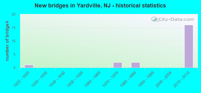
- New bridges - historical statistics
- 11920-1929
- 21970-1979
- 21980-1989
- 162010-2019


- Bridge Condition - Deck
- 30.0%Very good
- 60.0%Good
- 10.0%Satisfactory

- Bridge Condition - Superstructure
- 30.0%Very good
- 50.0%Good
- 20.0%Satisfactory

- Bridge Condition - Substructure
- 30.0%Very good
- 40.0%Good
- 30.0%Satisfactory
Find on map >> Show street view
Structure Number: 1122153, Location: 1.4 MI SOUTH OF I-195 (Lat: 40.189061, Lng: -74.652439), Route carried "on" structure: US 130, Year Built: 1928, Year Reconstructed: 2005, Status: Open, Structure Length: 0.70m (2.30ft), Average Daily Traffic: 28,911 (year 2020), Truck Traffic: 4%, Average Future Daily Traffic: 34,694 (year 2040), Design Load: HL 93, Features Intersected: BACK BROOK
Minimum Vertical Clearance: 30+ m (98+ ft), Kilometerpoint: 96.705, Lanes on structure: 4, Base Highway Network: Yes, Owner: State Highway Agency, Approaching Roadway Width: 23.2m (76.1ft), Skew: 20 degrees, Material/Design: Prestressed concrete, Design/Construction: Box Beam or Girders - Multiple, Number Of Spans In Main Unit: 1, Length of Maximum Span: 6.4m (21.0ft), Curb or Sidewalk Widths: Left: 1.8m (5.9ft), Right: 1.8m (5.9ft), Curb-To-Curb Width: 23.2m (76.1ft), Out-to-Out Width: 32.3m (106.0ft)
Condition: Deck: Good, Superstructure: Very good, Substructure: Satisfactory, Channel: Fair, Operating Rating: 26.2 metric tons, Method Used To Determine Operating Rating: Load and Resistance Factor Rating (LRFR) rating reported by rating factor(RF) method using HL-93 loadings, Inventory Rating: 20.4 metric tons, Method Used To Determine Inventory Rating: Load and Resistance Factor Rating (LRFR) rating reported by rating factor(RF) method using HL-93 loadings, Structural Evaluation: Somewhat better than minimum adequacy, Deck Geometry: Superior to present desirable criteria, Waterway Adequacy: Equal to present desirable criteria, Approach Roadway Alignment: Equal to present desirable criteria, Designated Inspection Frequency: Every 24 months, Inspection Date: June 2020, Deck Structure Type: Concrete Cast-file-Place, Wearing Surface/Protective System: Wearing Surface: Monolithic Concrete
Find on map >> Show street view
Structure Number: 1134153, Location: 0.7 MI. EAST OF RT 206 (Lat: 40.181669, Lng: -74.703331), Route carried "on" structure: Interstate 195, Year Built: 1986, Status: Open, Structure Length: 4.42m (14.50ft), Average Daily Traffic: 34,748 (year 2021), Truck Traffic: 9%, Average Future Daily Traffic: 42,398 (year 2041), Design Load: HS 20, Features Intersected: SOUTH BROAD ST E.B.
Minimum Vertical Clearance: 30+ m (98+ ft), Kilometerpoint: 2.494, Lanes on structure: 1, Lanes under structure: 4, Base Highway Network: Yes, Owner: State Highway Agency, Approaching Roadway Width: 12.8m (42.0ft), Skew: 2 degrees, Material/Design: Steel, Design/Construction: Stringer/Multi-beam, Number Of Spans In Main Unit: 1, Length of Maximum Span: 42.7m (140.1ft), Curb-To-Curb Width: 12.8m (42.0ft), Out-to-Out Width: 14.0m (45.9ft)
Condition: Deck: Good, Superstructure: Satisfactory, Substructure: Satisfactory, Inventory Rating: 77.1 metric tons, Method Used To Determine Inventory Rating: Load Factor (LF), Structural Evaluation: Equal to present minimum criteria, Deck Geometry: Somewhat better than minimum adequacy, Underclear: Better than present minimum criteria, Approach Roadway Alignment: Better than present minimum criteria, Designated Inspection Frequency: Every 24 months, Inspection Date: November 2021, Deck Structure Type: Concrete Cast-file-Place, Wearing Surface/Protective System: Wearing Surface: Bituminous, Membrane: Preformed Fabric, Deck Protection: Epoxy Coated Reinforcing
Find on map >> Show street view
Structure Number: M05905, Location: Service Area 6N (Lat: 40.179228, Lng: -74.624975), Route carried "on" structure: Ramp Interstate 95, Year Built: 2013, Status: Open, Structure Length: 15.61m (51.21ft), Average Daily Traffic: 5,670 (year 2020), Truck Traffic: 1%, Average Future Daily Traffic: 6,919 (year 2040), Design Load: HL 93, Features Intersected: NJTPK (I-95), Facility Carried by Structure: Ramp SANI
Minimum Vertical Clearance: 30+ m (98+ ft), Kilometerpoint: 22.080, Lanes on structure: 1, Lanes under structure: 3, Toll: On toll road, Owner: State Toll Authority, Approaching Roadway Width: 9.8m (32.2ft), Material/Design: Steel continuous, Design/Construction: Stringer/Multi-beam, Number Of Spans In Main Unit: 3, Length of Maximum Span: 59.1m (193.9ft), Curb-To-Curb Width: 9.8m (32.2ft), Out-to-Out Width: 11.0m (36.1ft)
Condition: Deck: Good, Superstructure: Good, Substructure: Very good, Operating Rating: 47.6 metric tons, Method Used To Determine Operating Rating: Load and Resistance Factor Rating (LRFR) rating reported by rating factor(RF) method using HL-93 loadings, Inventory Rating: 36.6 metric tons, Method Used To Determine Inventory Rating: Load and Resistance Factor Rating (LRFR) rating reported by rating factor(RF) method using HL-93 loadings, Structural Evaluation: Better than present minimum criteria, Deck Geometry: Superior to present desirable criteria, Underclear: Meets minimum limits, Approach Roadway Alignment: Equal to present desirable criteria, Designated Inspection Frequency: Every 24 months, Critical Feature Inspection Frequency: Every 24 months, Inspection Date: June 2020, Critical Feature Inspection Date: June 2020, Deck Structure Type: Concrete Cast-file-Place, Wearing Surface/Protective System: Wearing Surface: Monolithic Concrete, Deck Protection: Epoxy Coated Reinforcing
Find on map >> Show street view
Structure Number: M05908, Location: Service Area 6S (Lat: 40.180844, Lng: -74.623650), Route carried "on" structure: Ramp Interstate 95, Year Built: 2013, Status: Open, Structure Length: 14.33m (47.01ft), Average Daily Traffic: 5,818 (year 2020), Truck Traffic: 1%, Average Future Daily Traffic: 7,099 (year 2040), Design Load: HL 93, Features Intersected: NJTPK (I-95), Facility Carried by Structure: Ramp NISA
Minimum Vertical Clearance: 30+ m (98+ ft), Kilometerpoint: 22.128, Lanes on structure: 1, Lanes under structure: 3, Toll: On toll road, Owner: State Toll Authority, Approaching Roadway Width: 9.4m (30.8ft), Material/Design: Steel continuous, Design/Construction: Stringer/Multi-beam, Number Of Spans In Main Unit: 3, Length of Maximum Span: 54.9m (180.1ft), Curb-To-Curb Width: 9.5m (31.2ft), Out-to-Out Width: 10.7m (35.1ft)
Condition: Deck: Very good, Superstructure: Good, Substructure: Good, Operating Rating: 55.1 metric tons, Method Used To Determine Operating Rating: Load and Resistance Factor Rating (LRFR) rating reported by rating factor(RF) method using HL-93 loadings, Inventory Rating: 42.4 metric tons, Method Used To Determine Inventory Rating: Load and Resistance Factor Rating (LRFR) rating reported by rating factor(RF) method using HL-93 loadings, Structural Evaluation: Better than present minimum criteria, Deck Geometry: Superior to present desirable criteria, Underclear: Somewhat better than minimum adequacy, Approach Roadway Alignment: Equal to present desirable criteria, Designated Inspection Frequency: Every 24 months, Critical Feature Inspection Frequency: Every 24 months, Inspection Date: June 2020, Critical Feature Inspection Date: June 2020, Deck Structure Type: Concrete Cast-file-Place, Wearing Surface/Protective System: Wearing Surface: Monolithic Concrete, Deck Protection: Epoxy Coated Reinforcing
Find on map >> Show street view
Structure Number: M05923R, Location: 1.3 mi. South of Int. 7A (Lat: 40.181558, Lng: -74.621919), Route carried "on" structure: City street , Year Built: 2012, Status: Open, Structure Length: 14.94m (49.02ft), Average Daily Traffic: 2,924 (year 2020), Truck Traffic: 1%, Average Future Daily Traffic: 3,566 (year 2040), Design Load: HL 93, Features Intersected: Turnpike Mainline, Facility Carried by Structure: Merrick Road
Minimum Vertical Clearance: 30+ m (98+ ft), Kilometerpoint: 0.000, Lanes on structure: 2, Lanes under structure: 16, Owner: State Toll Authority, Approaching Roadway Width: 9.1m (29.9ft), Skew: 2 degrees, Material/Design: Steel continuous, Design/Construction: Stringer/Multi-beam, Number Of Spans In Main Unit: 3, Length of Maximum Span: 54.9m (180.1ft), Curb-To-Curb Width: 9.1m (29.9ft), Out-to-Out Width: 10.2m (33.5ft)
Condition: Deck: Good, Superstructure: Very good, Substructure: Very good, Operating Rating: 53.8 metric tons, Method Used To Determine Operating Rating: Load and Resistance Factor Rating (LRFR) rating reported by rating factor(RF) method using HL-93 loadings, Inventory Rating: 41.5 metric tons, Method Used To Determine Inventory Rating: Load and Resistance Factor Rating (LRFR) rating reported by rating factor(RF) method using HL-93 loadings, Structural Evaluation: Equal to present desirable criteria, Deck Geometry: Meets minimum limits, Underclear: High priority of corrective action, Approach Roadway Alignment: Equal to present desirable criteria, Designated Inspection Frequency: Every 24 months, Inspection Date: January 2020, Deck Structure Type: Concrete Cast-file-Place, Wearing Surface/Protective System: Wearing Surface: Monolithic Concrete, Deck Protection: Epoxy Coated Reinforcing
Find on map >> Show street view
Structure Number: M06033R, Location: 0.17 MI SOUTH of EXIT 7A (Lat: 40.191250, Lng: -74.606194), Route carried "on" structure: City street , Year Built: 2011, Status: Open, Structure Length: 17.22m (56.50ft), Average Daily Traffic: 1,328 (year 2020), Truck Traffic: 3%, Average Future Daily Traffic: 1,620 (year 2040), Design Load: HL 93, Features Intersected: NJ TPK(I-95), Facility Carried by Structure: EDGEBROOK ROAD
Minimum Vertical Clearance: 30+ m (98+ ft), Kilometerpoint: 0.660, Lanes on structure: 2, Lanes under structure: 16, Owner: State Toll Authority, Approaching Roadway Width: 9.1m (29.9ft), Skew: 1 degrees, Material/Design: Steel continuous, Design/Construction: Stringer/Multi-beam, Number Of Spans In Main Unit: 5, Length of Maximum Span: 48.8m (160.1ft), Curb-To-Curb Width: 9.1m (29.9ft), Out-to-Out Width: 10.2m (33.5ft)
Condition: Deck: Very good, Superstructure: Good, Substructure: Good, Operating Rating: 35.3 metric tons, Method Used To Determine Operating Rating: Load and Resistance Factor Rating (LRFR) rating reported by rating factor(RF) method using HL-93 loadings, Inventory Rating: 27.2 metric tons, Method Used To Determine Inventory Rating: Load and Resistance Factor Rating (LRFR) rating reported by rating factor(RF) method using HL-93 loadings, Structural Evaluation: Equal to present minimum criteria, Deck Geometry: Somewhat better than minimum adequacy, Underclear: High priority of corrective action, Approach Roadway Alignment: Equal to present desirable criteria, Designated Inspection Frequency: Every 24 months, Inspection Date: May 2020, Deck Structure Type: Concrete Cast-file-Place, Wearing Surface/Protective System: Wearing Surface: Monolithic Concrete, Deck Protection: Epoxy Coated Reinforcing
Find on map >> Show street view
Structure Number: M06051B, Location: AT INT. 7A (Lat: 40.197053, Lng: -74.610964), Route carried "on" structure: Ramp Interstate 95, Year Built: 1972, Status: Open, Structure Length: 5.43m (17.81ft), Average Daily Traffic: 16,423 (year 2020), Truck Traffic: 14%, Average Future Daily Traffic: 20,039 (year 2040), Design Load: HS 20, Features Intersected: I-195, Facility Carried by Structure: NJTPK Ramps ET&TW
Minimum Vertical Clearance: 30+ m (98+ ft), Kilometerpoint: 24.430, Lanes on structure: 2, Lanes under structure: 5, Toll: On toll road, Owner: State Toll Authority, Approaching Roadway Width: 15.2m (49.9ft), Skew: 20 degrees, Material/Design: Steel, Design/Construction: Stringer/Multi-beam, Number Of Spans In Main Unit: 2, Length of Maximum Span: 27.4m (89.9ft), Curb-To-Curb Width: 15.2m (49.9ft), Out-to-Out Width: 17.7m (58.1ft)
Condition: Deck: Satisfactory, Superstructure: Satisfactory, Substructure: Satisfactory, Operating Rating: 62.9 metric tons, Method Used To Determine Operating Rating: Load and Resistance Factor Rating (LRFR) rating reported by rating factor(RF) method using HL-93 loadings, Inventory Rating: 48.3 metric tons, Method Used To Determine Inventory Rating: Load and Resistance Factor Rating (LRFR) rating reported by rating factor(RF) method using HL-93 loadings, Structural Evaluation: Equal to present minimum criteria, Deck Geometry: Superior to present desirable criteria, Underclear: High priority of corrective action, Approach Roadway Alignment: Equal to present desirable criteria, Length Of Structure Improvement: 5.43m (17.81ft), Designated Inspection Frequency: Every 24 months, Inspection Date: June 2020, Bridge Improvement Cost: $200,000, Roadway Improvement Cost: $50,000, Total Project Cost: $300,000 ( Estimate for 2018), Deck Structure Type: Concrete Cast-file-Place, Wearing Surface/Protective System: Wearing Surface: Bituminous, Membrane: Preformed Fabric, Deck Protection: Epoxy Coated Reinforcing
Find on map >> Show street view
Structure Number: M06051C, Location: At Interchange 7A (Lat: 40.192414, Lng: -74.602597), Route carried "on" structure: Ramp Other road 95, Year Built: 2012, Status: Open, Structure Length: 14.20m (46.59ft), Average Daily Traffic: 3,971 (year 2020), Truck Traffic: 14%, Average Future Daily Traffic: 4,846 (year 2040), Design Load: HL 93, Features Intersected: NJTPK, Facility Carried by Structure: NJTPK Ramp ST
Minimum Vertical Clearance: 30+ m (98+ ft), Kilometerpoint: 24.140, Lanes on structure: 2, Lanes under structure: 14, Toll: On toll road, Owner: State Toll Authority, Approaching Roadway Width: 12.2m (40.0ft), Skew: 2 degrees, Material/Design: Steel continuous, Design/Construction: Stringer/Multi-beam, Number Of Spans In Main Unit: 3, Length of Maximum Span: 53.3m (174.9ft), Curb-To-Curb Width: 12.3m (40.4ft), Out-to-Out Width: 13.4m (44.0ft)
Condition: Deck: Very good, Superstructure: Very good, Substructure: Very good, Operating Rating: 49.9 metric tons, Method Used To Determine Operating Rating: Load and Resistance Factor Rating (LRFR) rating reported by rating factor(RF) method using HL-93 loadings, Inventory Rating: 38.6 metric tons, Method Used To Determine Inventory Rating: Load and Resistance Factor Rating (LRFR) rating reported by rating factor(RF) method using HL-93 loadings, Structural Evaluation: Equal to present desirable criteria, Deck Geometry: Superior to present desirable criteria, Underclear: Somewhat better than minimum adequacy, Approach Roadway Alignment: Equal to present desirable criteria, Designated Inspection Frequency: Every 24 months, Inspection Date: June 2020, Deck Structure Type: Concrete Cast-file-Place, Wearing Surface/Protective System: Wearing Surface: Monolithic Concrete, Deck Protection: Epoxy Coated Reinforcing
Find on map >> Show street view
Structure Number: M06051E, Location: At Interchange 7A (Lat: 40.191986, Lng: -74.604686), Route carried "on" structure: Ramp Interstate 95, Year Built: 2012, Status: Open, Structure Length: 9.81m (32.19ft), Average Daily Traffic: 4,405 (year 2020), Truck Traffic: 1%, Average Future Daily Traffic: 5,375 (year 2040), Design Load: HL 93, Features Intersected: NJTPK (I-95), Facility Carried by Structure: Ramp TSI
Minimum Vertical Clearance: 30+ m (98+ ft), Kilometerpoint: 24.430, Lanes on structure: 1, Lanes under structure: 3, Toll: On toll road, Owner: State Toll Authority, Approaching Roadway Width: 8.8m (28.9ft), Material/Design: Steel continuous, Design/Construction: Stringer/Multi-beam, Number Of Spans In Main Unit: 2, Length of Maximum Span: 48.8m (160.1ft), Curb-To-Curb Width: 8.8m (28.9ft), Out-to-Out Width: 9.9m (32.5ft)
Condition: Deck: Good, Superstructure: Good, Substructure: Good, Operating Rating: 22.7 metric tons, Method Used To Determine Operating Rating: Load and Resistance Factor Rating (LRFR) rating reported by rating factor(RF) method using HL-93 loadings, Inventory Rating: 17.5 metric tons, Method Used To Determine Inventory Rating: Load and Resistance Factor Rating (LRFR) rating reported by rating factor(RF) method using HL-93 loadings, Structural Evaluation: Meets minimum limits, Deck Geometry: Superior to present desirable criteria, Underclear: Somewhat better than minimum adequacy, Approach Roadway Alignment: Equal to present desirable criteria, Designated Inspection Frequency: Every 24 months, Critical Feature Inspection Frequency: Every 24 months, Inspection Date: June 2020, Critical Feature Inspection Date: June 2020, Deck Structure Type: Concrete Cast-file-Place, Wearing Surface/Protective System: Wearing Surface: Monolithic Concrete, Deck Protection: Epoxy Coated Reinforcing
Find on map >> Show street view
Structure Number: M06051F, Location: At Interchange 7A (Lat: 40.189525, Lng: -74.607183), Route carried "on" structure: Ramp Interstate 95, Year Built: 2012, Status: Open, Structure Length: 12.62m (41.40ft), Average Daily Traffic: 3,931 (year 2020), Truck Traffic: 1%, Average Future Daily Traffic: 4,797 (year 2040), Design Load: HL 93, Features Intersected: NJTPK (I-95), Facility Carried by Structure: Ramp SIT
Minimum Vertical Clearance: 30+ m (98+ ft), Kilometerpoint: 25.750, Lanes on structure: 1, Lanes under structure: 3, Toll: On toll road, Owner: State Toll Authority, Approaching Roadway Width: 8.5m (27.9ft), Material/Design: Steel continuous, Design/Construction: Stringer/Multi-beam, Number Of Spans In Main Unit: 3, Length of Maximum Span: 42.1m (138.1ft), Curb-To-Curb Width: 8.6m (28.2ft), Out-to-Out Width: 9.8m (32.2ft)
Condition: Deck: Good, Superstructure: Good, Substructure: Good, Operating Rating: 44.1 metric tons, Method Used To Determine Operating Rating: Load and Resistance Factor Rating (LRFR) rating reported by rating factor(RF) method using HL-93 loadings, Inventory Rating: 34.0 metric tons, Method Used To Determine Inventory Rating: Load and Resistance Factor Rating (LRFR) rating reported by rating factor(RF) method using HL-93 loadings, Structural Evaluation: Better than present minimum criteria, Deck Geometry: Superior to present desirable criteria, Underclear: Somewhat better than minimum adequacy, Approach Roadway Alignment: Equal to present desirable criteria, Designated Inspection Frequency: Every 24 months, Critical Feature Inspection Frequency: Every 24 months, Inspection Date: June 2020, Critical Feature Inspection Date: June 2020, Deck Structure Type: Concrete Cast-file-Place, Wearing Surface/Protective System: Wearing Surface: Monolithic Concrete, Deck Protection: Epoxy Coated Reinforcing
Find on map >> Show street view
Structure Number: 1134153, Location: 0.7 MI. EAST OF RT 206 (Lat: 40.181669, Lng: -74.703331), Route carried "under" structure: County highway 524, Year Built: 1986, Structure Length: 0. m, Average Daily Traffic: 11,034 (year 2021), Truck Traffic: 4%, Features Intersected: SOUTH BROAD ST E.B., Facility Carried by Structure: I-195 EASTBOUND
Minimum Vertical Clearance: 6.93m (22.74ft), Kilometerpoint: 0.982, Lanes on structure: 1, Lanes under structure: 4, Material/Design: Steel, Design/Construction: Stringer/Multi-beam, Length of Maximum Span: 42.7m (140.1ft)
Find on map >> Show street view
Structure Number: M05905, Location: Service Area 6N (Lat: 40.179228, Lng: -74.624975), Route carried "under" structure: Interstate 95, Year Built: 2013, Structure Length: 0. m, Average Daily Traffic: 28,351 (year 2020), Truck Traffic: 1%, Features Intersected: NJTPK (I-95), Facility Carried by Structure: Ramp SANI
Minimum Vertical Clearance: 5.03m (16.50ft), Kilometerpoint: 22.080, Lanes on structure: 1, Lanes under structure: 3, Toll: On toll road, Material/Design: Steel continuous, Design/Construction: Stringer/Multi-beam, Length of Maximum Span: 59.1m (193.9ft)
Find on map >> Show street view
Structure Number: M05908, Location: Service Area 6S (Lat: 40.180844, Lng: -74.623650), Route carried "under" structure: Interstate 95, Year Built: 2013, Structure Length: 0. m, Average Daily Traffic: 26,353 (year 2020), Truck Traffic: 14%, Features Intersected: NJTPK (I-95), Facility Carried by Structure: Ramp NISA
Minimum Vertical Clearance: 5.58m (18.31ft), Kilometerpoint: 22.128, Lanes on structure: 1, Lanes under structure: 3, Toll: On toll road, Material/Design: Steel continuous, Design/Construction: Stringer/Multi-beam, Length of Maximum Span: 54.9m (180.1ft)
Find on map >> Show street view
Structure Number: M05923R, Location: 1.3 mi. South of Int. 7A (Lat: 40.181558, Lng: -74.621919), Route carried "under" structure: Interstate 95, Year Built: 2012, Structure Length: 0. m, Average Daily Traffic: 114,918 (year 2020), Truck Traffic: 13%, Features Intersected: Turnpike Mainline, Facility Carried by Structure: Merrick Road
Minimum Vertical Clearance: 5.16m (16.93ft), Kilometerpoint: 22.338, Lanes on structure: 2, Lanes under structure: 16, Material/Design: Steel continuous, Design/Construction: Stringer/Multi-beam, Length of Maximum Span: 54.9m (180.1ft)
Find on map >> Show street view
Structure Number: M06033R, Location: 0.17 MI SOUTH of EXIT 7A (Lat: 40.191250, Lng: -74.606194), Route carried "under" structure: Ramp Interstate 95, Year Built: 2011, Structure Length: 0. m, Average Daily Traffic: 20,230 (year 2020), Truck Traffic: 14%, Features Intersected: NJ TPK(I-95), Facility Carried by Structure: EDGEBROOK ROAD
Minimum Vertical Clearance: 5.28m (17.32ft), Kilometerpoint: 24.108, Lanes on structure: 2, Lanes under structure: 1, Toll: On toll road, Material/Design: Steel continuous, Design/Construction: Stringer/Multi-beam, Length of Maximum Span: 48.8m (160.1ft)
Find on map >> Show street view
Structure Number: M06033R, Location: 0.17 MI SOUTH of EXIT 7A (Lat: 40.191250, Lng: -74.606194), Route carried "under" structure: Ramp Interstate 95, Year Built: 2011, Structure Length: 0. m, Average Daily Traffic: 21,230 (year 2020), Truck Traffic: 1%, Features Intersected: NJ TPK(I-95), Facility Carried by Structure: EDGEBROOK ROAD
Minimum Vertical Clearance: 5.72m (18.77ft), Kilometerpoint: 24.108, Lanes on structure: 2, Lanes under structure: 1, Toll: On toll road, Material/Design: Steel continuous, Design/Construction: Stringer/Multi-beam, Length of Maximum Span: 48.8m (160.1ft)
Find on map >> Show street view
Structure Number: M06033R, Location: 0.17 MI SOUTH of EXIT 7A (Lat: 40.191250, Lng: -74.606194), Route carried "under" structure: Interstate 95, Year Built: 2011, Structure Length: 0. m, Average Daily Traffic: 114,918 (year 2020), Truck Traffic: 14%, Features Intersected: NJ TPK(I-95), Facility Carried by Structure: EDGEBROOK ROAD
Minimum Vertical Clearance: 10.31m (33.83ft), Kilometerpoint: 24.108, Lanes on structure: 2, Lanes under structure: 12, Toll: On toll road, Material/Design: Steel continuous, Design/Construction: Stringer/Multi-beam, Length of Maximum Span: 48.8m (160.1ft)
Find on map >> Show street view
Structure Number: M06051B, Location: AT INT. 7A (Lat: 40.197053, Lng: -74.610964), Route carried "under" structure: Interstate 195, Year Built: 1972, Structure Length: 0. m, Average Daily Traffic: 63,214 (year 2020), Truck Traffic: 9%, Features Intersected: I-195, Facility Carried by Structure: NJTPK Ramps ET&TW
Minimum Vertical Clearance: 4.55m (14.93ft), Kilometerpoint: 10.058, Lanes on structure: 2, Lanes under structure: 5, Material/Design: Steel, Design/Construction: Stringer/Multi-beam, Length of Maximum Span: 27.4m (89.9ft)
Find on map >> Show street view
Structure Number: M06051C, Location: At Interchange 7A (Lat: 40.192414, Lng: -74.602597), Route carried "under" structure: Ramp Other road 95, Year Built: 2012, Structure Length: 0. m, Average Daily Traffic: 23,096 (year 2020), Truck Traffic: 14%, Features Intersected: NJTPK, Facility Carried by Structure: NJTPK Ramp ST
Minimum Vertical Clearance: 5.21m (17.09ft), Kilometerpoint: 24.140, Lanes on structure: 2, Lanes under structure: 2, Toll: On toll road, Material/Design: Steel continuous, Design/Construction: Stringer/Multi-beam, Length of Maximum Span: 53.3m (174.9ft)
Find on map >> Show street view
Structure Number: M06051E, Location: At Interchange 7A (Lat: 40.191986, Lng: -74.604686), Route carried "under" structure: Interstate 95, Year Built: 2012, Structure Length: 0. m, Average Daily Traffic: 28,819 (year 2020), Truck Traffic: 15%, Features Intersected: NJTPK (I-95), Facility Carried by Structure: Ramp TSI
Minimum Vertical Clearance: 5.05m (16.57ft), Kilometerpoint: 24.430, Lanes on structure: 1, Lanes under structure: 3, Toll: On toll road, Material/Design: Steel continuous, Design/Construction: Stringer/Multi-beam, Length of Maximum Span: 48.8m (160.1ft)
Find on map >> Show street view
Structure Number: M06051F, Location: At Interchange 7A (Lat: 40.189525, Lng: -74.607183), Route carried "under" structure: Interstate 95, Year Built: 2012, Structure Length: 0. m, Average Daily Traffic: 31,805 (year 2020), Truck Traffic: 14%, Features Intersected: NJTPK (I-95), Facility Carried by Structure: Ramp SIT
Minimum Vertical Clearance: 5.11m (16.77ft), Kilometerpoint: 25.750, Lanes on structure: 1, Lanes under structure: 3, Toll: On toll road, Material/Design: Steel continuous, Design/Construction: Stringer/Multi-beam, Length of Maximum Span: 42.1m (138.1ft)