Bridge Statistics for Zillah, Washington (WA)
Condition, Traffic, Stress, Structural Evaluation, Project Costs
- National Bridge Inventory (NBI) Statistics
- 23Number of bridges
- 361ft / 110mTotal length
- $88,393,000Total costs
- 236,784Total average daily traffic
- 30,317Total average daily truck traffic
- National Bridge Inventory (NBI) Registered Bridges for Zillah
- No street view available for this location
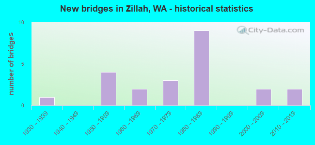
- New bridges - historical statistics
- 11930-1939
- 41950-1959
- 21960-1969
- 31970-1979
- 91980-1989
- 22000-2009
- 22010-2019


- Bridge Condition - Deck
- 25.0%Very good
- 25.0%Good
- 37.5%Satisfactory
- 12.5%Poor

- Bridge Condition - Superstructure
- 31.3%Very good
- 18.8%Good
- 37.5%Satisfactory
- 12.5%Fair

- Bridge Condition - Substructure
- 31.3%Very good
- 43.8%Good
- 25.0%Satisfactory

- Bridge Condition - Channel
- 80.0%Very good
- 6.7%Good
- 13.3%Fair

- Bridge Condition - Culverts
- 50.0%Good
- 50.0%Satisfactory
Find on map >> Show street view
Structure Number: 1935A, Location: 0.4 E JCT I-82 (Lat: 46.410969, Lng: -120.314333), Route carried "on" structure: State highway 22, Year Built: 1935, Status: Open, Structure Length: 16.61m (54.49ft), Average Daily Traffic: 8,958 (year 2019), Truck Traffic: 8%, Average Future Daily Traffic: 11,752 (year 2039), Design Load: H 15, Features Intersected: YAKIMA R
Minimum Vertical Clearance: 30+ m (98+ ft), Kilometerpoint: 1.770, Lanes on structure: 2, Base Highway Network: Yes, Owner: State Highway Agency, Approaching Roadway Width: 9.8m (32.2ft), Material/Design: Steel continuous, Design/Construction: Stringer/Multi-beam, Number Of Spans In Main Unit: 6, Length of Maximum Span: 27.4m (89.9ft), Curb or Sidewalk Widths: Left: 1.1m (3.6ft), Right: 0.0m, Curb-To-Curb Width: 7.3m (24.0ft), Out-to-Out Width: 9.1m (29.9ft)
Condition: Deck: Satisfactory, Superstructure: Fair, Substructure: Satisfactory, Channel: Fair, Operating Rating: 54.4 metric tons, Method Used To Determine Operating Rating: Load Factor (LF), Inventory Rating: 32.7 metric tons, Method Used To Determine Inventory Rating: Load Factor (LF), Structural Evaluation: Somewhat better than minimum adequacy, Deck Geometry: High priority of replacement, Waterway Adequacy: Equal to present desirable criteria, Approach Roadway Alignment: Equal to present desirable criteria, Length Of Structure Improvement: 16.61m (54.49ft), Designated Inspection Frequency: Every 24 months, Underwater Inspection Frequency: Every 60 months, Inspection Date: September 2021, Underwater Inspection Date: August 2018, Bridge Improvement Cost: $3,706,000, Roadway Improvement Cost: $741,000, Total Project Cost: $7,412,000 ( Estimate for 2014), Deck Structure Type: Concrete Cast-file-Place, Wearing Surface/Protective System: Wearing Surface: Latex Concrete
Find on map >> Show street view
Structure Number: 10862A, Location: 4.0 E JCT SR 22 (Lat: 46.391611, Lng: -120.240833), Route carried "on" structure: County highway , Year Built: 1978, Status: Open, Structure Length: 10.24m (33.60ft), Average Daily Traffic: 2,913 (year 2016), Truck Traffic: 15%, Average Future Daily Traffic: 4,094 (year 2038), Design Load: HS 20+Mod, Features Intersected: I-82, Facility Carried by Structure: YAKIMA VALLEY HWY
Minimum Vertical Clearance: 30+ m (98+ ft), Kilometerpoint: 0.097, Lanes on structure: 2, Lanes under structure: 4, Owner: State Highway Agency, Approaching Roadway Width: 12.2m (40.0ft), Skew: 4 degrees, Material/Design: Prestressed concrete continuous, Design/Construction: Box Beam or Girders - Multiple, Number Of Spans In Main Unit: 2, Length of Maximum Span: 54.3m (178.1ft), Curb-To-Curb Width: 12.2m (40.0ft), Out-to-Out Width: 13.1m (43.0ft)
Condition: Deck: Good, Superstructure: Good, Substructure: Good, Operating Rating: 64.4 metric tons, Method Used To Determine Operating Rating: Load Factor (LF), Inventory Rating: 38.1 metric tons, Method Used To Determine Inventory Rating: Load Factor (LF), Structural Evaluation: Better than present minimum criteria, Deck Geometry: Equal to present minimum criteria, Underclear: Equal to present minimum criteria, Approach Roadway Alignment: Equal to present desirable criteria, Length Of Structure Improvement: 10.24m (33.60ft), Designated Inspection Frequency: Every 24 months, Inspection Date: July 2021, Bridge Improvement Cost: $2,822,000, Roadway Improvement Cost: $564,000, Total Project Cost: $5,645,000 ( Estimate for 2014), Deck Structure Type: Concrete Cast-file-Place, Wearing Surface/Protective System: Wearing Surface: Monolithic Concrete
Find on map >> Show street view
Structure Number: 11169A, Location: JCT I-82 (Lat: 46.416639, Lng: -120.314167), Route carried "on" structure: State highway 22, Year Built: 1980, Status: Open, Structure Length: 7.25m (23.79ft), Average Daily Traffic: 7,243 (year 2019), Truck Traffic: 8%, Average Future Daily Traffic: 9,502 (year 2039), Design Load: HS 20+Mod, Features Intersected: I-82
Minimum Vertical Clearance: 30+ m (98+ ft), Kilometerpoint: 1.127, Lanes on structure: 4, Lanes under structure: 5, Base Highway Network: Yes, Owner: State Highway Agency, Approaching Roadway Width: 20.7m (67.9ft), Skew: 1 degrees, Material/Design: Concrete continuous, Design/Construction: Box Beam or Girders - Multiple, Number Of Spans In Main Unit: 2, Length of Maximum Span: 39.6m (129.9ft), Curb-To-Curb Width: 20.7m (67.9ft), Out-to-Out Width: 21.6m (70.9ft)
Condition: Deck: Poor, Superstructure: Good, Substructure: Good, Operating Rating: 89.8 metric tons, Method Used To Determine Operating Rating: Load Factor (LF), Inventory Rating: 68.9 metric tons, Method Used To Determine Inventory Rating: Load Factor (LF), Structural Evaluation: Better than present minimum criteria, Deck Geometry: Superior to present desirable criteria, Underclear: Somewhat better than minimum adequacy, Approach Roadway Alignment: Equal to present desirable criteria, Length Of Structure Improvement: 7.25m (23.79ft), Designated Inspection Frequency: Every 24 months, Inspection Date: May 2020, Bridge Improvement Cost: $3,332,000, Roadway Improvement Cost: $666,000, Total Project Cost: $6,664,000 ( Estimate for 2014), Deck Structure Type: Concrete Cast-file-Place, Wearing Surface/Protective System: Wearing Surface: Monolithic Concrete, Deck Protection: Epoxy Coated Reinforcing
Find on map >> Show street view
Structure Number: 11169B, Location: 0.2 E JCT I-82 (Lat: 46.414353, Lng: -120.314386), Route carried "on" structure: State highway 22, Year Built: 1979, Status: Open, Structure Length: 17.37m (56.99ft), Average Daily Traffic: 8,958 (year 2019), Truck Traffic: 8%, Average Future Daily Traffic: 11,752 (year 2039), Design Load: HS 20+Mod, Features Intersected: BEAVER CRK
Minimum Vertical Clearance: 30+ m (98+ ft), Kilometerpoint: 1.400, Lanes on structure: 3, Base Highway Network: Yes, Owner: State Highway Agency, Approaching Roadway Width: 15.8m (51.8ft), Material/Design: Prestressed concrete continuous, Design/Construction: Stringer/Multi-beam, Number Of Spans In Main Unit: 6, Length of Maximum Span: 33.5m (109.9ft), Curb-To-Curb Width: 15.8m (51.8ft), Out-to-Out Width: 16.8m (55.1ft)
Condition: Deck: Poor, Superstructure: Satisfactory, Substructure: Satisfactory, Channel: Good, Operating Rating: 43.5 metric tons, Method Used To Determine Operating Rating: Load Factor (LF), Inventory Rating: 25.4 metric tons, Method Used To Determine Inventory Rating: Load Factor (LF), Structural Evaluation: Equal to present minimum criteria, Deck Geometry: Better than present minimum criteria, Waterway Adequacy: Equal to present desirable criteria, Approach Roadway Alignment: Equal to present desirable criteria, Length Of Structure Improvement: 17.37m (56.99ft), Designated Inspection Frequency: Every 24 months, Inspection Date: June 2020, Bridge Improvement Cost: $6,156,000, Roadway Improvement Cost: $1,231,000, Total Project Cost: $12,312,000 ( Estimate for 2014), Deck Structure Type: Concrete Cast-file-Place, Wearing Surface/Protective System: Wearing Surface: Monolithic Concrete, Deck Protection: Epoxy Coated Reinforcing
Find on map >> Show street view
Structure Number: 11509A, Location: 2.0 E JCT SR 22 (Lat: 46.403306, Lng: -120.278667), Route carried "on" structure: County highway , Year Built: 1980, Status: Open, Structure Length: 6.25m (20.51ft), Average Daily Traffic: 6,986 (year 2016), Truck Traffic: 15%, Average Future Daily Traffic: 9,820 (year 2038), Design Load: HS 20+Mod, Features Intersected: I-82, Facility Carried by Structure: N MEYERS RD
Minimum Vertical Clearance: 30+ m (98+ ft), Kilometerpoint: 0.080, Lanes on structure: 3, Lanes under structure: 4, Owner: State Highway Agency, Approaching Roadway Width: 16.8m (55.1ft), Material/Design: Concrete continuous, Design/Construction: Box Beam or Girders - Multiple, Number Of Spans In Main Unit: 2, Length of Maximum Span: 31.4m (103.0ft), Curb-To-Curb Width: 16.8m (55.1ft), Out-to-Out Width: 17.7m (58.1ft)
Condition: Deck: Satisfactory, Superstructure: Satisfactory, Substructure: Good, Operating Rating: 67.1 metric tons, Method Used To Determine Operating Rating: Load Factor (LF), Inventory Rating: 39.9 metric tons, Method Used To Determine Inventory Rating: Load Factor (LF), Structural Evaluation: Equal to present minimum criteria, Deck Geometry: Superior to present desirable criteria, Underclear: Equal to present minimum criteria, Approach Roadway Alignment: Equal to present desirable criteria, Length Of Structure Improvement: 6.25m (20.51ft), Designated Inspection Frequency: Every 24 months, Inspection Date: July 2021, Bridge Improvement Cost: $2,337,000, Roadway Improvement Cost: $467,000, Total Project Cost: $4,674,000 ( Estimate for 2014), Deck Structure Type: Concrete Cast-file-Place, Wearing Surface/Protective System: Wearing Surface: Monolithic Concrete, Deck Protection: Epoxy Coated Reinforcing
Find on map >> Show street view
Structure Number: 200029, Location: 3.0 E JCT SR 22 (Lat: 46.398333, Lng: -120.261667), Route carried "on" structure: Interstate 82, Year Built: 1980, Status: Open, Structure Length: 1.31m (4.30ft), Average Daily Traffic: 24,772 (year 2019), Truck Traffic: 15%, Average Future Daily Traffic: 32,500 (year 2039), Features Intersected: WASTEWATER DRAINAGE
Minimum Vertical Clearance: 30+ m (98+ ft), Kilometerpoint: 85.360, Lanes on structure: 4, Base Highway Network: Yes, Owner: State Highway Agency, Approaching Roadway Width: 23.2m (76.1ft), Skew: 10 degrees, Material/Design: Steel, Design/Construction: Culvert, Number Of Spans In Main Unit: 2, Length of Maximum Span: 5.5m (18.0ft)
Condition: Channel: Very good, Culverts: Good, Operating Rating: 89.8 metric tons, Method Used To Determine Operating Rating: Load Factor (LF), Inventory Rating: 89.8 metric tons, Method Used To Determine Inventory Rating: Load Factor (LF), Structural Evaluation: Better than present minimum criteria, Waterway Adequacy: Equal to present desirable criteria, Approach Roadway Alignment: Equal to present desirable criteria, Length Of Structure Improvement: 1.31m (4.30ft), Designated Inspection Frequency: Every 48 months, Inspection Date: Febuary 2018, Bridge Improvement Cost: $671,000, Roadway Improvement Cost: $134,000, Total Project Cost: $1,342,000 ( Estimate for 2014)
Find on map >> Show street view
Structure Number: 200035, Location: 0.8 E JCT SR 22 (Lat: 46.415344, Lng: -120.303500), Route carried "on" structure: Interstate 82, Year Built: 1980, Year Reconstructed: 1993, Status: Open, Structure Length: 1.25m (4.10ft), Average Daily Traffic: 25,429 (year 2019), Truck Traffic: 15%, Average Future Daily Traffic: 33,362 (year 2039), Features Intersected: CANAL
Minimum Vertical Clearance: 30+ m (98+ ft), Kilometerpoint: 81.755, Lanes on structure: 4, Base Highway Network: Yes, Owner: State Highway Agency, Approaching Roadway Width: 23.2m (76.1ft), Skew: 10 degrees, Material/Design: Steel, Design/Construction: Culvert, Number Of Spans In Main Unit: 5, Length of Maximum Span: 1.8m (5.9ft)
Condition: Channel: Very good, Culverts: Satisfactory, Operating Rating: 89.8 metric tons, Method Used To Determine Operating Rating: Load Factor (LF), Inventory Rating: 89.8 metric tons, Method Used To Determine Inventory Rating: Load Factor (LF), Structural Evaluation: Equal to present minimum criteria, Waterway Adequacy: Equal to present desirable criteria, Approach Roadway Alignment: Equal to present desirable criteria, Length Of Structure Improvement: 1.25m (4.10ft), Designated Inspection Frequency: Every 24 months, Inspection Date: Febuary 2020, Bridge Improvement Cost: $640,000, Roadway Improvement Cost: $128,000, Total Project Cost: $1,279,000 ( Estimate for 2014)
Find on map >> Show street view
Structure Number: 80546, Location: 00.05 N.OF E.ZILLAH (Lat: 46.403333, Lng: -120.240000), Route carried "on" structure: County highway 61120, Year Built: 1958, Status: Open, Structure Length: 3.84m (12.60ft), Average Daily Traffic: 1,385 (year 2019), Truck Traffic: 5%, Average Future Daily Traffic: 1,525 (year 2039), Design Load: HS 20, Features Intersected: S.V.I.D. CANAL, Facility Carried by Structure: YAKIMA VALLEY HWY
Minimum Vertical Clearance: 30+ m (98+ ft), Kilometerpoint: 0.001, Lanes on structure: 2, Owner: County Highway Agency, Approaching Roadway Width: 11.0m (36.1ft), Skew: 2 degrees, Material/Design: Concrete continuous, Design/Construction: Slab, Number Of Spans In Main Unit: 3, Length of Maximum Span: 15.2m (49.9ft), Curb or Sidewalk Widths: Left: 0.9m (3.0ft), Right: 0.9m (3.0ft), Curb-To-Curb Width: 13.1m (43.0ft), Out-to-Out Width: 15.0m (49.2ft)
Condition: Deck: Satisfactory, Superstructure: Satisfactory, Substructure: Satisfactory, Channel: Very good, Operating Rating: 68.0 metric tons, Method Used To Determine Operating Rating: Load Factor (LF), Inventory Rating: 40.8 metric tons, Method Used To Determine Inventory Rating: Load Factor (LF), Structural Evaluation: Equal to present minimum criteria, Deck Geometry: Better than present minimum criteria, Waterway Adequacy: Equal to present desirable criteria, Approach Roadway Alignment: Equal to present desirable criteria, Length Of Structure Improvement: 4.15m (13.62ft), Designated Inspection Frequency: Every 24 months, Inspection Date: Febuary 2021, Bridge Improvement Cost: $2,067,000, Roadway Improvement Cost: $413,000, Total Project Cost: $4,134,000 ( Estimate for 2014), Deck Structure Type: Concrete Cast-file-Place, Wearing Surface/Protective System: Wearing Surface: Monolithic Concrete
Find on map >> Show street view
Structure Number: 82265, Location: 00.17 E LUCY LANE (Lat: 46.433075, Lng: -120.226675), Route carried "on" structure: County highway 67540, Year Built: 1965, Status: Posted for load, Structure Length: 2.38m (7.81ft), Average Daily Traffic: 380 (year 2020), Truck Traffic: 5%, Average Future Daily Traffic: 450 (year 2040), Design Load: HS 20, Features Intersected: ROZA CANAL, Facility Carried by Structure: HIGHLAND DRIVE
Minimum Vertical Clearance: 30+ m (98+ ft), Kilometerpoint: 0.001, Lanes on structure: 2, Owner: County Highway Agency, Approaching Roadway Width: 7.3m (24.0ft), Material/Design: Prestressed concrete, Design/Construction: Stringer/Multi-beam, Number Of Spans In Main Unit: 1, Length of Maximum Span: 23.5m (77.1ft), Curb or Sidewalk Widths: Left: 0.2m (0.7ft), Right: 0.2m (0.7ft), Curb-To-Curb Width: 8.0m (26.2ft), Out-to-Out Width: 8.5m (27.9ft)
Condition: Deck: Satisfactory, Superstructure: Satisfactory, Substructure: Good, Channel: Very good, Operating Rating: 21.4 metric tons, Method Used To Determine Operating Rating: Load and Resistance Factor Rating (LRFR) rating reported by rating factor(RF) method using HL-93 loadings, Inventory Rating: 8.1 metric tons, Method Used To Determine Inventory Rating: Load and Resistance Factor Rating (LRFR) rating reported by rating factor(RF) method using HL-93 loadings, Structural Evaluation: High priority of replacement, Deck Geometry: Somewhat better than minimum adequacy, Waterway Adequacy: Equal to present desirable criteria, Approach Roadway Alignment: Equal to present desirable criteria, Bridge Posting: Required (Relationship of Operating Rating to Maximum Legal Load: 0.1 - 9.9% below), Length Of Structure Improvement: 2.68m (8.79ft), Designated Inspection Frequency: Every 24 months, Inspection Date: November 2020, Bridge Improvement Cost: $1,338,000, Roadway Improvement Cost: $268,000, Total Project Cost: $2,675,000 ( Estimate for 2014), Deck Structure Type: Other, Wearing Surface/Protective System: Wearing Surface: Bituminous
Find on map >> Show street view
Structure Number: 83443, Location: 00.02 W OF SCHOOLEY (Lat: 46.415928, Lng: -120.253700), Route carried "on" structure: County highway 61120, Year Built: 1958, Status: Open, Structure Length: 3.84m (12.60ft), Average Daily Traffic: 1,624 (year 2019), Truck Traffic: 5%, Average Future Daily Traffic: 1,800 (year 2039), Design Load: HS 20, Features Intersected: S.V.I.D. CANAL, Facility Carried by Structure: YAKIMA VALLEY HWY
Minimum Vertical Clearance: 30+ m (98+ ft), Kilometerpoint: 0.001, Lanes on structure: 2, Owner: County Highway Agency, Approaching Roadway Width: 6.7m (22.0ft), Skew: 2 degrees, Material/Design: Concrete continuous, Design/Construction: Slab, Number Of Spans In Main Unit: 3, Length of Maximum Span: 15.2m (49.9ft), Curb or Sidewalk Widths: Left: 0.9m (3.0ft), Right: 0.9m (3.0ft), Curb-To-Curb Width: 8.6m (28.2ft), Out-to-Out Width: 10.5m (34.4ft)
Condition: Deck: Satisfactory, Superstructure: Satisfactory, Substructure: Good, Channel: Very good, Operating Rating: 49.0 metric tons, Method Used To Determine Operating Rating: Load Factor (LF), Inventory Rating: 29.0 metric tons, Method Used To Determine Inventory Rating: Load Factor (LF), Structural Evaluation: Equal to present minimum criteria, Deck Geometry: Somewhat better than minimum adequacy, Waterway Adequacy: Equal to present desirable criteria, Approach Roadway Alignment: Equal to present desirable criteria, Length Of Structure Improvement: 4.15m (13.62ft), Designated Inspection Frequency: Every 24 months, Inspection Date: Febuary 2021, Bridge Improvement Cost: $2,067,000, Roadway Improvement Cost: $413,000, Total Project Cost: $4,134,000 ( Estimate for 2014), Deck Structure Type: Concrete Cast-file-Place, Wearing Surface/Protective System: Wearing Surface: Monolithic Concrete
Find on map >> Show street view
Structure Number: 84365, Location: 00.02 E LUCY LANE (Lat: 46.403958, Lng: -120.230928), Route carried "on" structure: County highway 60250, Year Built: 1967, Status: Open, Structure Length: 4.27m (14.01ft), Average Daily Traffic: 2,680 (year 2021), Truck Traffic: 10%, Average Future Daily Traffic: 3,200 (year 2041), Design Load: HS 20, Features Intersected: SVID CANAL, Facility Carried by Structure: ZILLAH DR.,E.
Minimum Vertical Clearance: 30+ m (98+ ft), Kilometerpoint: 0.001, Lanes on structure: 2, Owner: County Highway Agency, Approaching Roadway Width: 7.3m (24.0ft), Skew: 3 degrees, Material/Design: Prestressed concrete, Design/Construction: Stringer/Multi-beam, Number Of Spans In Main Unit: 1, Number Of Approach Spans: 2, Length of Maximum Span: 29.9m (98.1ft), Curb or Sidewalk Widths: Left: 0.3m (1.0ft), Right: 0.3m (1.0ft), Curb-To-Curb Width: 10.1m (33.1ft), Out-to-Out Width: 10.7m (35.1ft)
Condition: Deck: Good, Superstructure: Good, Substructure: Good, Channel: Very good, Operating Rating: 47.2 metric tons, Method Used To Determine Operating Rating: Load Factor (LF), Inventory Rating: 28.1 metric tons, Method Used To Determine Inventory Rating: Load Factor (LF), Structural Evaluation: Better than present minimum criteria, Deck Geometry: Meets minimum limits, Waterway Adequacy: Equal to present desirable criteria, Approach Roadway Alignment: Equal to present desirable criteria, Length Of Structure Improvement: 4.57m (14.99ft), Designated Inspection Frequency: Every 24 months, Inspection Date: March 2021, Bridge Improvement Cost: $2,280,000, Roadway Improvement Cost: $456,000, Total Project Cost: $4,560,000 ( Estimate for 2014), Deck Structure Type: Concrete Cast-file-Place, Wearing Surface/Protective System: Wearing Surface: Bituminous
Find on map >> Show street view
Structure Number: 84779, Location: 00.04 N FRALEY ROAD (Lat: 46.393300, Lng: -120.287717), Route carried "on" structure: County highway 70410, Year Built: 1958, Status: Posted for load, Structure Length: 0.98m (3.22ft), Average Daily Traffic: 6,903 (year 2019), Truck Traffic: 5%, Average Future Daily Traffic: 6,950 (year 2039), Design Load: H 20, Features Intersected: DRY WASH, Facility Carried by Structure: MEYERS RD.,N.
Minimum Vertical Clearance: 30+ m (98+ ft), Kilometerpoint: 0.001, Lanes on structure: 2, Owner: County Highway Agency, Approaching Roadway Width: 6.7m (22.0ft), Material/Design: Concrete, Design/Construction: Channel Beam, Number Of Spans In Main Unit: 1, Length of Maximum Span: 9.4m (30.8ft), Curb-To-Curb Width: 7.1m (23.3ft), Out-to-Out Width: 7.3m (24.0ft)
Condition: Deck: Good, Superstructure: Fair, Substructure: Good, Channel: Very good, Operating Rating: 13.6 metric tons, Method Used To Determine Operating Rating: Load and Resistance Factor Rating (LRFR) rating reported by rating factor(RF) method using HL-93 loadings, Inventory Rating: 10.7 metric tons, Method Used To Determine Inventory Rating: Load and Resistance Factor Rating (LRFR) rating reported by rating factor(RF) method using HL-93 loadings, Structural Evaluation: High priority of replacement, Deck Geometry: High priority of replacement, Waterway Adequacy: Equal to present desirable criteria, Approach Roadway Alignment: Equal to present desirable criteria, Bridge Posting: Required (Relationship of Operating Rating to Maximum Legal Load: > 39.9% below), Length Of Structure Improvement: 1.28m (4.20ft), Designated Inspection Frequency: Every 24 months, Inspection Date: Febuary 2021, Bridge Improvement Cost: $638,000, Roadway Improvement Cost: $128,000, Total Project Cost: $1,277,000 ( Estimate for 2014), Deck Structure Type: Other, Wearing Surface/Protective System: Wearing Surface: Bituminous
Find on map >> Show street view
Structure Number: 84787, Location: 00.78 N OF FRALEY (Lat: 46.401633, Lng: -120.279761), Route carried "on" structure: County highway 70410, Year Built: 1980, Status: Open, Structure Length: 3.99m (13.09ft), Average Daily Traffic: 6,903 (year 2019), Truck Traffic: 5%, Average Future Daily Traffic: 8,945 (year 2039), Design Load: HS 20, Features Intersected: SLOUGH, Facility Carried by Structure: MEYERS RD N IRRIG
Minimum Vertical Clearance: 30+ m (98+ ft), Kilometerpoint: 0.001, Lanes on structure: 2, Owner: County Highway Agency, Approaching Roadway Width: 7.9m (25.9ft), Material/Design: Prestressed concrete, Design/Construction: Stringer/Multi-beam, Number Of Spans In Main Unit: 1, Length of Maximum Span: 39.0m (128.0ft), Curb-To-Curb Width: 12.2m (40.0ft), Out-to-Out Width: 13.2m (43.3ft)
Condition: Deck: Good, Superstructure: Very good, Substructure: Very good, Channel: Very good, Operating Rating: 89.8 metric tons, Method Used To Determine Operating Rating: Load Factor (LF), Inventory Rating: 65.3 metric tons, Method Used To Determine Inventory Rating: Load Factor (LF), Structural Evaluation: Equal to present desirable criteria, Deck Geometry: Somewhat better than minimum adequacy, Waterway Adequacy: Equal to present desirable criteria, Approach Roadway Alignment: Equal to present desirable criteria, Length Of Structure Improvement: 4.30m (14.11ft), Designated Inspection Frequency: Every 24 months, Inspection Date: Febuary 2021, Bridge Improvement Cost: $2,143,000, Roadway Improvement Cost: $429,000, Total Project Cost: $4,286,000 ( Estimate for 2014), Deck Structure Type: Concrete Cast-file-Place, Wearing Surface/Protective System: Wearing Surface: Monolithic Concrete, Deck Protection: Epoxy Coated Reinforcing
Find on map >> Show street view
Structure Number: 86492, Location: 0.01 S OF SCHOOLEY (Lat: 46.419869, Lng: -120.262058), Route carried "on" structure: County highway 67350, Year Built: 2000, Status: Open, Structure Length: 2.56m (8.40ft), Average Daily Traffic: 991 (year 2019), Truck Traffic: 5%, Average Future Daily Traffic: 980 (year 2039), Design Load: HS 25 or greater, Features Intersected: SVID CANAL, Facility Carried by Structure: ROZA DR.
Minimum Vertical Clearance: 30+ m (98+ ft), Kilometerpoint: 0.001, Lanes on structure: 2, Owner: County Highway Agency, Approaching Roadway Width: 7.6m (24.9ft), Material/Design: Prestressed concrete, Design/Construction: Stringer/Multi-beam, Number Of Spans In Main Unit: 1, Length of Maximum Span: 25.0m (82.0ft), Curb-To-Curb Width: 9.6m (31.5ft), Out-to-Out Width: 9.8m (32.2ft)
Condition: Deck: Very good, Superstructure: Very good, Substructure: Very good, Channel: Very good, Operating Rating: 63.5 metric tons, Method Used To Determine Operating Rating: Load Factor (LF), Inventory Rating: 47.2 metric tons, Method Used To Determine Inventory Rating: Load Factor (LF), Structural Evaluation: Equal to present desirable criteria, Deck Geometry: Equal to present minimum criteria, Waterway Adequacy: Equal to present desirable criteria, Approach Roadway Alignment: Equal to present desirable criteria, Length Of Structure Improvement: 2.87m (9.42ft), Designated Inspection Frequency: Every 24 months, Inspection Date: Febuary 2021, Bridge Improvement Cost: $1,429,000, Roadway Improvement Cost: $286,000, Total Project Cost: $2,858,000 ( Estimate for 2014), Deck Structure Type: Other, Wearing Surface/Protective System: Wearing Surface: Monolithic Concrete, Deck Protection: Epoxy Coated Reinforcing
Find on map >> Show street view
Structure Number: 86568, Location: 0.42 S. OF HIGHLAND DR. (Lat: 46.426667, Lng: -120.271667), Route carried "on" structure: County highway 67450, Year Built: 2001, Status: Open, Structure Length: 2.83m (9.28ft), Average Daily Traffic: 1,522 (year 2019), Truck Traffic: 10%, Average Future Daily Traffic: 1,950 (year 2039), Design Load: HS 20, Features Intersected: SVID CANAL, Facility Carried by Structure: CHEYNE RD.
Minimum Vertical Clearance: 30+ m (98+ ft), Kilometerpoint: 0.001, Lanes on structure: 2, Owner: County Highway Agency, Approaching Roadway Width: 6.4m (21.0ft), Skew: 2 degrees, Material/Design: Prestressed concrete, Design/Construction: Stringer/Multi-beam, Number Of Spans In Main Unit: 1, Length of Maximum Span: 26.8m (87.9ft), Curb-To-Curb Width: 10.9m (35.8ft), Out-to-Out Width: 11.0m (36.1ft)
Condition: Deck: Very good, Superstructure: Very good, Substructure: Very good, Channel: Very good, Operating Rating: 69.8 metric tons, Method Used To Determine Operating Rating: Load Factor (LF), Inventory Rating: 41.7 metric tons, Method Used To Determine Inventory Rating: Load Factor (LF), Structural Evaluation: Equal to present desirable criteria, Deck Geometry: Equal to present minimum criteria, Waterway Adequacy: Equal to present desirable criteria, Approach Roadway Alignment: Equal to present desirable criteria, Length Of Structure Improvement: 3.14m (10.30ft), Designated Inspection Frequency: Every 24 months, Inspection Date: Febuary 2021, Bridge Improvement Cost: $1,566,000, Roadway Improvement Cost: $313,000, Total Project Cost: $3,131,000 ( Estimate for 2014), Deck Structure Type: Other, Wearing Surface/Protective System: Wearing Surface: Monolithic Concrete, Deck Protection: Epoxy Coated Reinforcing
Find on map >> Show street view
Structure Number: 87103, Location: 00.12 east of Roza Dr. (Lat: 46.409108, Lng: -120.259572), Route carried "on" structure: City street 66950, Year Built: 1954, Status: Posted for load, Structure Length: 2.56m (8.40ft), Average Daily Traffic: 202 (year 2019), Truck Traffic: 5%, Average Future Daily Traffic: 222 (year 2039), Design Load: H 20, Features Intersected: SVID CANAL, Facility Carried by Structure: SCHOOLEY Rd.
Minimum Vertical Clearance: 30+ m (98+ ft), Kilometerpoint: 0.001, Lanes on structure: 2, Owner: City or Municipal Highway Agency, Approaching Roadway Width: 7.9m (25.9ft), Skew: 1 degrees, Material/Design: Steel, Design/Construction: Stringer/Multi-beam, Number Of Spans In Main Unit: 3, Length of Maximum Span: 18.3m (60.0ft), Curb or Sidewalk Widths: Left: 0.2m (0.7ft), Right: 0.2m (0.7ft), Curb-To-Curb Width: 7.3m (24.0ft), Out-to-Out Width: 7.8m (25.6ft)
Condition: Deck: Satisfactory, Superstructure: Satisfactory, Substructure: Satisfactory, Channel: Fair, Operating Rating: 10.0 metric tons, Method Used To Determine Operating Rating: Load and Resistance Factor Rating (LRFR) rating reported by rating factor(RF) method using HL-93 loadings, Inventory Rating: 6.8 metric tons, Method Used To Determine Inventory Rating: Load and Resistance Factor Rating (LRFR) rating reported by rating factor(RF) method using HL-93 loadings, Structural Evaluation: High priority of replacement, Deck Geometry: Somewhat better than minimum adequacy, Waterway Adequacy: Equal to present desirable criteria, Approach Roadway Alignment: Equal to present minimum criteria, Bridge Posting: Required (Relationship of Operating Rating to Maximum Legal Load: > 39.9% below), Length Of Structure Improvement: 2.87m (9.42ft), Designated Inspection Frequency: Every 24 months, Inspection Date: December 2020, Bridge Improvement Cost: $1,429,000, Roadway Improvement Cost: $286,000, Total Project Cost: $2,858,000 ( Estimate for 2014), Deck Structure Type: Concrete Cast-file-Place, Wearing Surface/Protective System: Wearing Surface: Monolithic Concrete
Find on map >> Show street view
Structure Number: 88944, Location: 0.28 N Fraley Rd (Lat: 46.395619, Lng: -120.284197), Route carried "on" structure: County highway 70410, Year Built: 2017, Status: Open, Structure Length: 3.87m (12.70ft), Average Daily Traffic: 7,050 (year 2019), Truck Traffic: 5%, Average Future Daily Traffic: 8,920 (year 2039), Design Load: HL 93, Features Intersected: Yakima River Branch, Facility Carried by Structure: Meyers Rd N
Minimum Vertical Clearance: 30+ m (98+ ft), Kilometerpoint: 0.001, Lanes on structure: 2, Owner: County Highway Agency, Approaching Roadway Width: 12.2m (40.0ft), Material/Design: Prestressed concrete, Design/Construction: Stringer/Multi-beam, Number Of Spans In Main Unit: 1, Length of Maximum Span: 37.8m (124.0ft), Curb-To-Curb Width: 12.5m (41.0ft), Out-to-Out Width: 13.3m (43.6ft)
Condition: Deck: Very good, Superstructure: Very good, Substructure: Very good, Channel: Very good, Operating Rating: 79.4 metric tons, Method Used To Determine Operating Rating: Load and Resistance Factor Rating (LRFR) rating reported by rating factor(RF) method using HL-93 loadings, Inventory Rating: 49.9 metric tons, Method Used To Determine Inventory Rating: Load and Resistance Factor Rating (LRFR) rating reported by rating factor(RF) method using HL-93 loadings, Structural Evaluation: Equal to present desirable criteria, Deck Geometry: Somewhat better than minimum adequacy, Waterway Adequacy: Equal to present desirable criteria, Approach Roadway Alignment: Equal to present desirable criteria, Designated Inspection Frequency: Every 24 months, Inspection Date: October 2021, Deck Structure Type: Concrete Cast-file-Place, Wearing Surface/Protective System: Wearing Surface: Monolithic Concrete, Deck Protection: Epoxy Coated Reinforcing
Find on map >> Show street view
Structure Number: 88945, Location: 00.59 N FRALEY ROAD (Lat: 46.400000, Lng: -120.280000), Route carried "on" structure: County highway 70410, Year Built: 2017, Status: Open, Structure Length: 18.90m (62.01ft), Average Daily Traffic: 6,750 (year 2021), Truck Traffic: 5%, Average Future Daily Traffic: 8,500 (year 2041), Design Load: HL 93, Features Intersected: YAKIMA RIVER, Facility Carried by Structure: MEYERS RD., N.
Minimum Vertical Clearance: 30+ m (98+ ft), Kilometerpoint: 5.150, Lanes on structure: 2, Owner: County Highway Agency, Approaching Roadway Width: 12.2m (40.0ft), Material/Design: Prestressed concrete continuous, Design/Construction: Stringer/Multi-beam, Number Of Spans In Main Unit: 4, Length of Maximum Span: 48.8m (160.1ft), Curb-To-Curb Width: 12.2m (40.0ft), Out-to-Out Width: 13.0m (42.7ft)
Condition: Deck: Very good, Superstructure: Very good, Substructure: Very good, Channel: Very good, Operating Rating: 66.7 metric tons, Method Used To Determine Operating Rating: Load and Resistance Factor Rating (LRFR) rating reported by rating factor(RF) method using HL-93 loadings, Inventory Rating: 50.2 metric tons, Method Used To Determine Inventory Rating: Load and Resistance Factor Rating (LRFR) rating reported by rating factor(RF) method using HL-93 loadings, Structural Evaluation: Equal to present desirable criteria, Deck Geometry: Somewhat better than minimum adequacy, Waterway Adequacy: Equal to present desirable criteria, Approach Roadway Alignment: Equal to present desirable criteria, Length Of Structure Improvement: 19.20m (62.99ft), Designated Inspection Frequency: Every 24 months, Inspection Date: December 2021, Bridge Improvement Cost: $9,576,000, Roadway Improvement Cost: $1,915,000, Total Project Cost: $19,152,000 ( Estimate for 2014), Deck Structure Type: Concrete Cast-file-Place, Wearing Surface/Protective System: Wearing Surface: Monolithic Concrete, Deck Protection: Epoxy Coated Reinforcing
Find on map >> Show street view
Structure Number: 10862A, Location: 4.0 E JCT SR 22 (Lat: 46.391611, Lng: -120.240833), Route carried "under" structure: Interstate 82, Year Built: 1978, Structure Length: 0. m, Average Daily Traffic: 21,792 (year 2019), Truck Traffic: 15%, Features Intersected: I-82, Facility Carried by Structure: YAKIMA VALLEY HWY
Minimum Vertical Clearance: 5.18m (16.99ft), Kilometerpoint: 87.033, Lanes on structure: 2, Lanes under structure: 4, Material/Design: Prestressed concrete continuous, Design/Construction: Box Beam or Girders - Multiple, Length of Maximum Span: 54.3m (178.1ft)
Find on map >> Show street view
Structure Number: 11169A, Location: 12.3 E JCT US 97 (Lat: 46.416639, Lng: -120.314167), Route carried "under" structure: Interstate 82, Year Built: 1980, Structure Length: 0. m, Average Daily Traffic: 22,684 (year 2019), Truck Traffic: 15%, Features Intersected: I-82, Facility Carried by Structure: SR 22
Minimum Vertical Clearance: 5.33m (17.49ft), Kilometerpoint: 80.644, Lanes on structure: 4, Lanes under structure: 5, Material/Design: Concrete continuous, Design/Construction: Box Beam or Girders - Multiple, Length of Maximum Span: 39.6m (129.9ft)
Find on map >> Show street view
Structure Number: 11509A, Location: 2.0 E JCT SR 22 (Lat: 46.403306, Lng: -120.278667), Route carried "under" structure: Interstate 82, Year Built: 1980, Structure Length: 0. m, Average Daily Traffic: 21,115 (year 2019), Truck Traffic: 15%, Features Intersected: I-82, Facility Carried by Structure: N MEYERS RD
Minimum Vertical Clearance: 5.84m (19.16ft), Kilometerpoint: 83.815, Lanes on structure: 3, Lanes under structure: 4, Material/Design: Concrete continuous, Design/Construction: Box Beam or Girders - Multiple, Length of Maximum Span: 31.4m (103.0ft)
Find on map >> Show street view
Structure Number: 11509C, Location: 3.6 E JCT SR 22 (Lat: 46.394500, Lng: -120.248917), Route carried "under" structure: Interstate 82, Year Built: 1980, Structure Length: 0. m, Average Daily Traffic: 24,772 (year 2019), Truck Traffic: 15%, Features Intersected: I-82, Facility Carried by Structure: RAILROAD
Minimum Vertical Clearance: 6.63m (21.75ft), Kilometerpoint: 86.325, Lanes under structure: 4, Material/Design: Steel continuous, Design/Construction: Box Beam or Girders - Single/Spread, Length of Maximum Span: 47.9m (157.2ft)
Find on map >> Show street view
Structure Number: 11509D, Location: 3.6 E JCT SR 22 (Lat: 46.394472, Lng: -120.248417), Route carried "under" structure: Interstate 82, Year Built: 1980, Structure Length: 0. m, Average Daily Traffic: 24,772 (year 2019), Truck Traffic: 15%, Features Intersected: I-82, Facility Carried by Structure: BN RR
Minimum Vertical Clearance: 6.73m (22.08ft), Kilometerpoint: 86.357, Lanes under structure: 4, Material/Design: Steel continuous, Design/Construction: Box Beam or Girders - Single/Spread, Length of Maximum Span: 46.3m (151.9ft)