Apache, Arizona
Submit your own pictures of this place and show them to the world
- OSM Map
- General Map
- Google Map
- MSN Map

| Males: 5,728 | |
| Females: 6,230 |
| Median resident age: | 21.3 years |
| Arizona median age: | 34.2 years |
Zip code: 85929
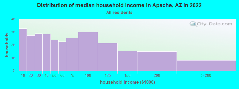
| Apache: | $33,298 |
| AZ: | $74,568 |
Estimated per capita income in 2022: $13,640 (it was $6,442 in 2000)
Apache CCD income, earnings, and wages data
Estimated median house or condo value in 2022: $113,555 (it was $36,600 in 2000)
| Apache: | $113,555 |
| AZ: | $402,800 |
Mean prices in 2022: all housing units: $270,870; detached houses: $303,591; townhouses or other attached units: $455,253; in 3-to-4-unit structures: $254,269; in 5-or-more-unit structures: $298,694; mobile homes: $130,620; occupied boats, rvs, vans, etc.: $18,692
Detailed information about poverty and poor residents in Apache, AZ
Compare current foreclosures near Apache, AZ:
| Photo | Address | Area | Beds / Baths | Price | Details |
|---|---|---|---|---|---|

|
#1
Mogollon Cir
Show Low, AZ 85901
|
- sq. feet
|
2 baths 3 beds |
show details | |

|
#2
S 27th Ave
Show Low, AZ 85901
|
972 sq. feet
|
1 baths 3 beds |
show details | |

|
#3
S 23rd Ave
Show Low, AZ 85901
|
1,446 sq. feet
|
- baths - beds |
show details | |

|
#4
N 26th Dr
Show Low, AZ 85901
|
1,280 sq. feet
|
- baths - beds |
show details | |

|
#5
N Woodland Rd # J
Lakeside, AZ 85929
|
- sq. feet
|
- baths - beds |
show details | |

|
#6
W Spyglass Dr
Show Low, AZ 85901
|
1,296 sq. feet
|
- baths - beds |
show details | |

|
#7
Acr 3590
Show Low, AZ 85901
|
- sq. feet
|
- baths - beds |
show details | |

|
#8
N 6th Dr
Show Low, AZ 85901
|
976 sq. feet
|
- baths - beds |
show details | |

|
#9
N 6th Dr
Show Low, AZ 85901
|
976 sq. feet
|
- baths - beds |
show details | |

|
#10
E Mcneil Apt C
Show Low, AZ 85901
|
- sq. feet
|
- baths - beds |
show details |
| Photo | Address | Area | Beds / Baths | Price | Details |
|---|---|---|---|---|---|

|
#11
W Mcneil Trlr 22
Show Low, AZ 85901
|
- sq. feet
|
- baths - beds |
show details | |

|
#12
Bull Elk Run
Show Low, AZ 85901
|
1,568 sq. feet
|
- baths - beds |
show details | |

|
#13
S 9th Ave
Show Low, AZ 85901
|
1,056 sq. feet
|
- baths - beds |
show details | |

|
#14
Homestead Rd Spc 70
Lakeside, AZ 85929
|
- sq. feet
|
- baths - beds |
show details | |

|
#15
Homestead Rd Spc 53
Lakeside, AZ 85929
|
- sq. feet
|
- baths - beds |
show details | |

|
#16
W Deuce Of Clubs Apt 238
Show Low, AZ 85901
|
- sq. feet
|
- baths - beds |
show details | |

|
#17
S Rosemarie Dr
Pinetop, AZ 85935
|
- sq. feet
|
- baths - beds |
show details | |

|
#18
S White Mountain Rd, Trlr 87
Show Low, AZ 85901
|
- sq. feet
|
- baths - beds |
show details | |

|
#19
S Donna Ln
Pinetop, AZ 85935
|
- sq. feet
|
- baths - beds |
show details | |

|
#20
Antler Ln
Show Low, AZ 85901
|
- sq. feet
|
- baths - beds |
show details |
| Photo | Address | Area | Beds / Baths | Price | Details |
|---|---|---|---|---|---|

|
#21
S Evergreen Dr
Pinetop, AZ 85935
|
- sq. feet
|
- baths - beds |
show details | |

|
#22
Oakwood Dr
Lakeside, AZ 85929
|
1,064 sq. feet
|
- baths - beds |
show details | |

|
#23
Vallery Ln
Lakeside, AZ 85929
|
- sq. feet
|
- baths - beds |
show details | |

|
#24
Sponseller Dr
Lakeside, AZ 85929
|
- sq. feet
|
- baths - beds |
show details | |

|
#25
Chiricahua Dr
Show Low, AZ 85901
|
- sq. feet
|
- baths - beds |
show details | |

|
#26
Ridge Dr W
Pinedale, AZ 85934
|
- sq. feet
|
- baths - beds |
show details | |

|
Check over 1 million property listings on Foreclosure.com!
|
browse all offers | |||

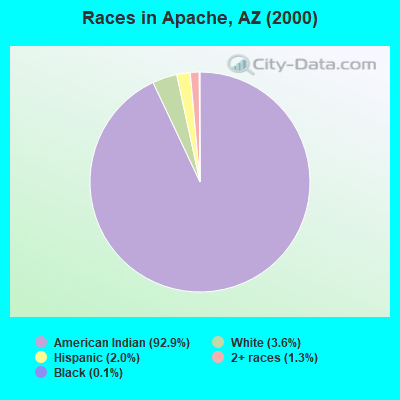
- 9,79792.9%American Indian alone
- 3793.6%White alone
- 2142.0%Hispanic
- 1331.3%Two or more races
- 140.1%Black alone
- 60.06%Asian alone
- 10.01%Native Hawaiian and Other
Pacific Islander alone - 10.01%Other race alone
 Recent articles from our blog. Our writers, many of them Ph.D. graduates or candidates, create easy-to-read articles on a wide variety of topics.

Current Local Time: MST (no DST) time zone
Elevation: 4381 feet
Land area: 1022.8 square miles.
Population density: 12 people per square mile (very low).

| Apache CCD: | 0.9% ($342) |
| Arizona: | 0.9% ($962) |
Nearest city with pop. 50,000+: North Pinal, AZ (87.8 miles  , pop. 59,965).
Nearest city with pop. 200,000+: Mesa, AZ (101.9 miles , pop. 396,375).
Nearest city with pop. 1,000,000+: Phoenix, AZ (116.5 miles , pop. 1,321,045).
Nearest cities:
), ), ), ), ), Latitude: 34.05 N, Longitude: 110.15 W

| Here: | 5.7% |
| Arizona: | 3.8% |
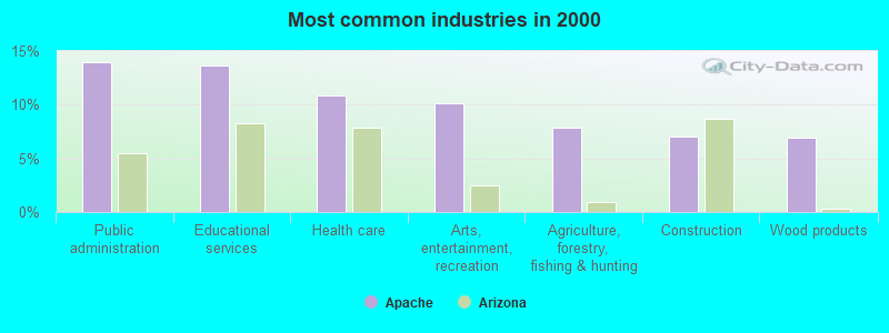
- Public administration (14.0%)
- Educational services (13.6%)
- Health care (10.9%)
- Arts, entertainment, recreation (10.1%)
- Agriculture, forestry, fishing & hunting (7.8%)
- Construction (7.0%)
- Wood products (7.0%)
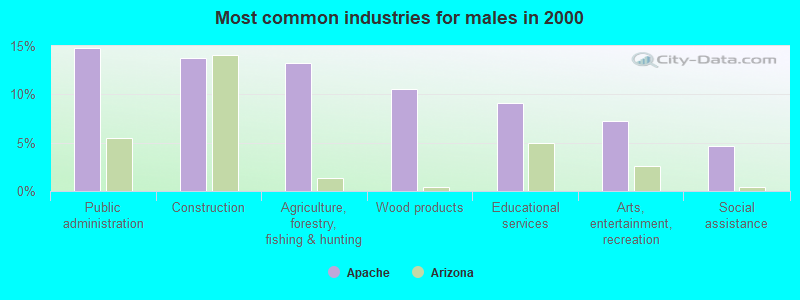
- Public administration (14.8%)
- Construction (13.8%)
- Agriculture, forestry, fishing & hunting (13.3%)
- Wood products (10.6%)
- Educational services (9.1%)
- Arts, entertainment, recreation (7.2%)
- Social assistance (4.6%)
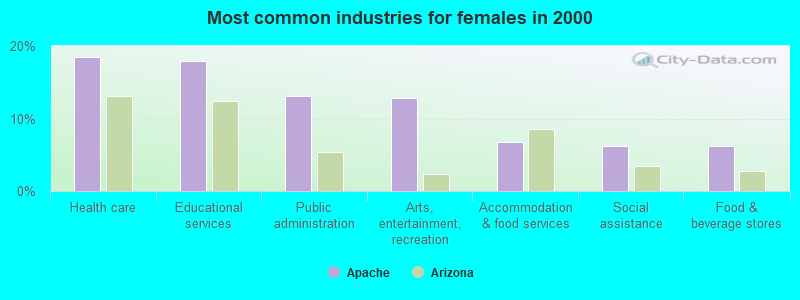
- Health care (18.5%)
- Educational services (18.0%)
- Public administration (13.2%)
- Arts, entertainment, recreation (12.8%)
- Accommodation & food services (6.8%)
- Social assistance (6.2%)
- Food & beverage stores (6.1%)
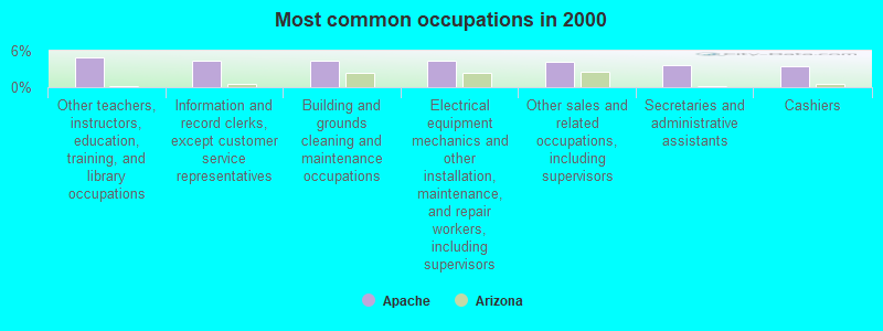
- Other teachers, instructors, education, training, and library occupations (4.9%)
- Information and record clerks, except customer service representatives (4.4%)
- Building and grounds cleaning and maintenance occupations (4.4%)
- Electrical equipment mechanics and other installation, maintenance, and repair workers, including supervisors (4.3%)
- Other sales and related occupations, including supervisors (4.2%)
- Secretaries and administrative assistants (3.7%)
- Cashiers (3.4%)
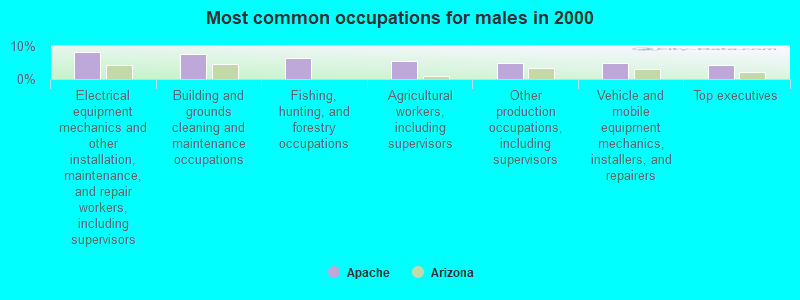
- Electrical equipment mechanics and other installation, maintenance, and repair workers, including supervisors (8.1%)
- Building and grounds cleaning and maintenance occupations (7.6%)
- Fishing, hunting, and forestry occupations (6.3%)
- Agricultural workers, including supervisors (5.5%)
- Other production occupations, including supervisors (4.8%)
- Vehicle and mobile equipment mechanics, installers, and repairers (4.8%)
- Top executives (4.3%)
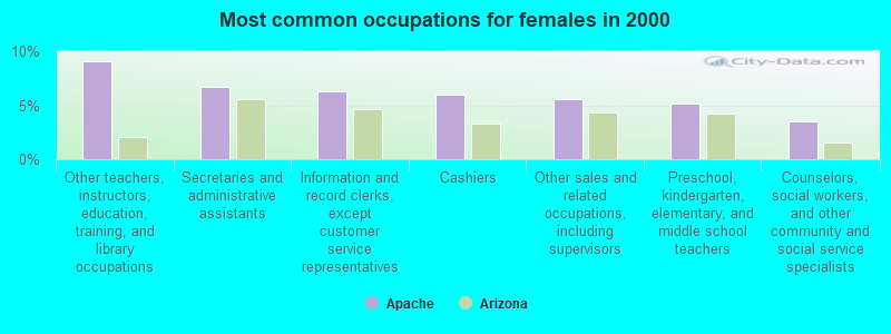
- Other teachers, instructors, education, training, and library occupations (9.1%)
- Secretaries and administrative assistants (6.7%)
- Information and record clerks, except customer service representatives (6.3%)
- Cashiers (6.0%)
- Other sales and related occupations, including supervisors (5.6%)
- Preschool, kindergarten, elementary, and middle school teachers (5.2%)
- Counselors, social workers, and other community and social service specialists (3.5%)
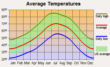
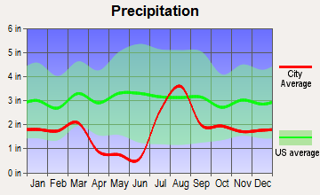
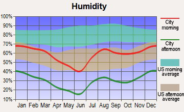
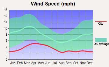
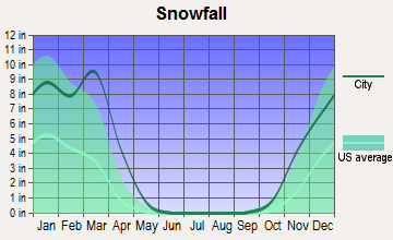
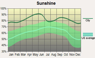
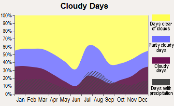
Average climate in Apache, Arizona
Based on data reported by over 4,000 weather stations
(lower is better)
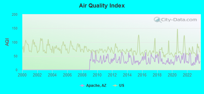
Air Quality Index (AQI) level in 2023 was 37.9. This is significantly better than average.
| City: | 37.9 |
| U.S.: | 72.6 |
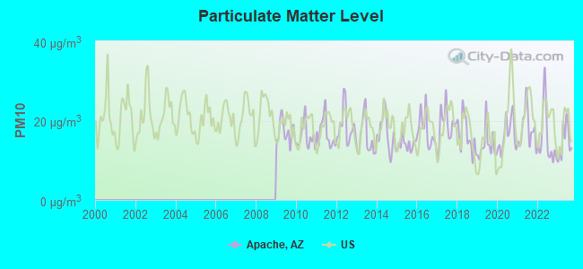
Particulate Matter (PM10) [µg/m3] level in 2023 was 14.8. This is better than average. Closest monitor was 15.6 miles away from the city center.
| City: | 14.8 |
| U.S.: | 19.2 |
Earthquake activity:
Apache-area historical earthquake activity is significantly above Arizona state average. It is 1538% greater than the overall U.S. average.On 6/28/1992 at 11:57:34, a magnitude 7.6 (6.2 MB, 7.6 MS, 7.3 MW, Depth: 0.7 mi, Class: Major, Intensity: VIII - XII) earthquake occurred 365.6 miles away from the city center, causing 3 deaths (1 shaking deaths, 2 other deaths) and 400 injuries, causing $100,000,000 total damage and $40,000,000 insured losses
On 10/16/1999 at 09:46:44, a magnitude 7.4 (6.3 MB, 7.4 MS, 7.2 MW, 7.3 ML) earthquake occurred 360.7 miles away from Apache center
On 5/19/1940 at 04:36:40, a magnitude 7.2 (7.2 UK) earthquake occurred 324.6 miles away from the city center, causing $33,000,000 total damage
On 12/31/1934 at 18:45:56, a magnitude 7.1 (7.1 UK) earthquake occurred 337.6 miles away from the city center
On 10/15/1979 at 23:16:54, a magnitude 7.0 (5.7 MB, 6.9 MS, 7.0 ML, 6.4 MW) earthquake occurred 328.2 miles away from Apache center
On 7/21/1952 at 11:52:14, a magnitude 7.7 (7.7 UK) earthquake occurred 508.6 miles away from the city center, causing $50,000,000 total damage
Magnitude types: body-wave magnitude (MB), local magnitude (ML), surface-wave magnitude (MS), moment magnitude (MW)
Natural disasters:
The number of natural disasters in Navajo County (19) is greater than the US average (15).Major Disasters (Presidential) Declared: 10
Emergencies Declared: 3
Causes of natural disasters: Floods: 8, Storms: 7, Fires: 6, Winter Storms: 2, Drought: 1, Flash Flood: 1, Heavy Rain: 1, Hurricane: 1, Tornado: 1, Other: 1 (Note: some incidents may be assigned to more than one category).
Hospitals and medical centers near Apache:
- SIERRA BLANCA REHABILITATION (Nursing Home, about 12 miles away; LAKESIDE, AZ)
- SUMMIT HEALTHCARE HOME HEALTH (Home Health Center, about 14 miles away; SHOW LOW, AZ)
- SUMMIT HEALTHCARE REGIONAL MEDICAL CENTER Acute Care Hospitals (about 14 miles away; SHOW LOW, AZ)
- TALL PINES CARE AND REHAB, INC (Nursing Home, about 14 miles away; SHOW LOW, AZ)
- SHOW LOW DIALYSIS (FMC) (Dialysis Facility, about 15 miles away; SHOW LOW, AZ)
Colleges/universities with over 2000 students nearest to Apache:
- Eastern Arizona College (about 87 miles; Thatcher, AZ; Full-time enrollment: 3,810)
- Arizona State University-Polytechnic (about 103 miles; Mesa, AZ; FT enrollment: 3,311)
- Scottsdale Community College (about 107 miles; Scottsdale, AZ; FT enrollment: 6,030)
- Le Cordon Bleu College of Culinary Arts-Scottsdale (about 108 miles; Scottsdale, AZ; FT enrollment: 2,123)
- Chandler-Gilbert Community College (about 109 miles; Chandler, AZ; FT enrollment: 8,047)
- Mesa Community College (about 110 miles; Mesa, AZ; FT enrollment: 14,726)
- Arizona State University-Skysong (about 110 miles; Scottsdale, AZ; FT enrollment: 5,445)
Points of interest:
Notable locations in Apache: Amos Ranch (A), Cooley Ranch (B), Deer Springs Guard Station (C), Forestdale Trading Post (D), Baha Ranch (E), Penrod Cabin (F), Pettis Ranch (G), West Ranch (H), Roberts Ranch (I), Blue Lake Campground (J), Bootleg Lake Campground (K), Cooley Lake Campground (L), Wildhorse Lake Campground (M), Scott Cabin (N), Chediski Farms (O), Chino Spring Stockman Station (P), Diamond Creek Junction Campground (Q), Alchesay National Fish Hatchery (R), Lower Log Road Campground (S), Martinez Ranch (T). Display/hide their locations on the map
Churches in Apache include: Whiteriver Lutheran Church (A), Saint Francis Church (B), McNary Apache Baptist Church (C). Display/hide their locations on the map
Cemeteries: Bush Flat Cemetery (1), Chief Alchesay Baha Grave (2), Sevenmile Cemetery (3), Whiteriver Cemetery (4). Display/hide their locations on the map
Lakes and reservoirs: Chuck Box Lake (A), Whitetail Lake (B), Nyce Lake (C), Pepper Lake (D), Wagon Wheel Lake (E), West Blue Lake (F), Hidden Lake (G), Wildhorse Lake (H). Display/hide their locations on the map
Streams, rivers, and creeks: East Fork White River (A), Bear Creek (B), Forestdale Creek (C), Bull Cienega Creek (D), Salt Creek (E), Mud Creek (F), Rock Creek (G), Bull Creek (H), North Fork White River (I). Display/hide their locations on the map
Birthplace of: Levi Stewart Udall - Politician.
| This place: | 4.0 people |
| Arizona: | 2.6 people |
| This place: | 52.2% |
| Whole state: | 68.2% |
| This place: | 9.3% |
| Whole state: | 6.2% |
Likely homosexual households (counted as self-reported same-sex unmarried-partner households)
- Lesbian couples: 0.5% of all households
- Gay men: 0.3% of all households
| This place: | 48.7% |
| Whole state: | 13.9% |
| This place: | 24.7% |
| Whole state: | 6.2% |
People in group quarters in Apache in 2000:
- 66 people in local jails and other confinement facilities (including police lockups)
- 29 people in agriculture workers' dormitories on farms
- 9 people in homes for abused, dependent, and neglected children
- 7 people in nursing homes
- 7 people in homes or halfway houses for drug/alcohol abuse
- 4 people in other nonhousehold living situations
- 3 people in religious group quarters
For population 15 years and over in Apache:
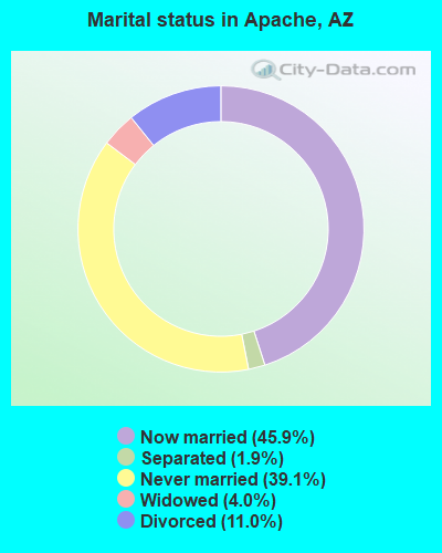
- Never married: 39.1%
- Now married: 45.9%
- Separated: 1.9%
- Widowed: 4.0%
- Divorced: 11.0%
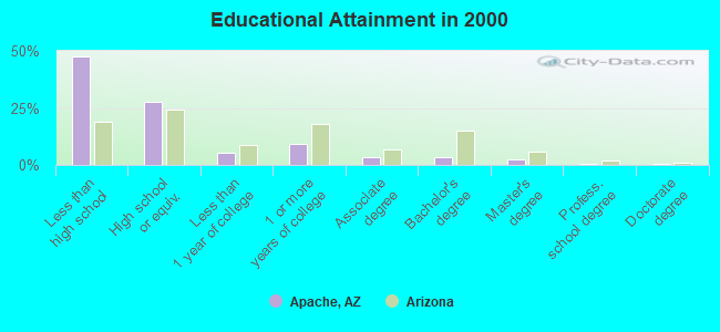
For population 25 years and over in Apache:
- High school or higher: 52.5%
- Bachelor's degree or higher: 7.0%
- Graduate or professional degree: 3.5%
- Unemployed: 21.7%
- Mean travel time to work (commute): 17.8 minutes
| Here: | 13.1 |
| Arizona average: | 13.1 |
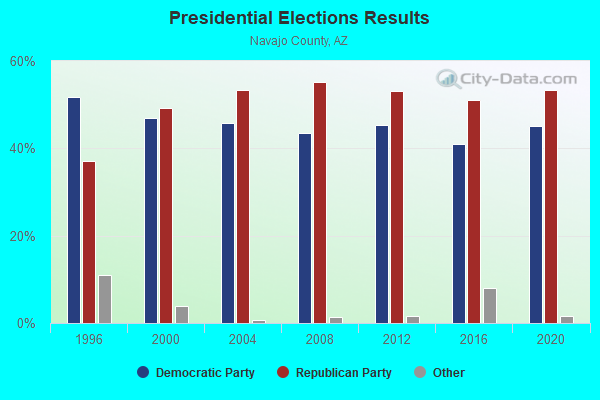
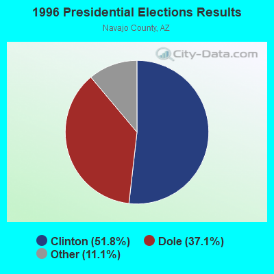
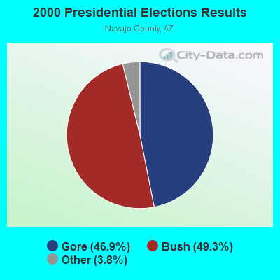
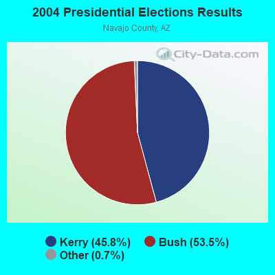
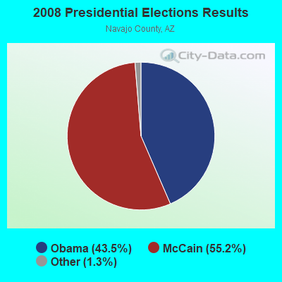
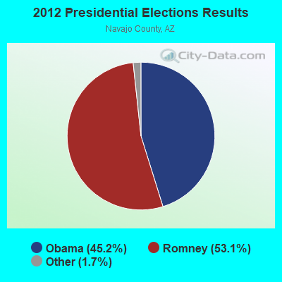
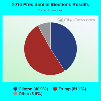
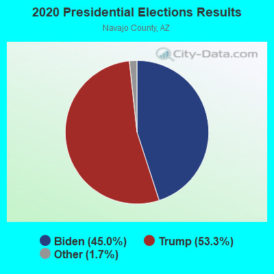
Graphs represent county-level data. Detailed 2008 Election Results
Religion statistics for Apache, AZ (based on Navajo County data)

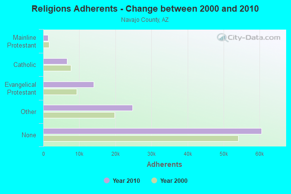
| Religion | Adherents | Congregations |
|---|---|---|
| Other | 24,727 | 62 |
| Evangelical Protestant | 13,966 | 98 |
| Catholic | 6,600 | 14 |
| Mainline Protestant | 1,410 | 18 |
| Black Protestant | 207 | 2 |
| None | 60,539 | - |
Food Environment Statistics:
| Navajo County: | 1.71 / 10,000 pop. |
| Arizona: | 1.36 / 10,000 pop. |
| This county: | 0.09 / 10,000 pop. |
| State: | 0.14 / 10,000 pop. |
| Navajo County: | 0.27 / 10,000 pop. |
| Arizona: | 0.55 / 10,000 pop. |
| Navajo County: | 4.95 / 10,000 pop. |
| State: | 2.47 / 10,000 pop. |
| Here: | 7.92 / 10,000 pop. |
| State: | 6.21 / 10,000 pop. |
| This county: | 12.7% |
| Arizona: | 8.0% |
| Navajo County: | 26.1% |
| Arizona: | 22.8% |
| This county: | 9.8% |
| State: | 14.2% |
Strongest AM radio stations in Apache:
- KVWM (970 AM; 5 kW; SHOW LOW, AZ; Owner: PETRACOM OF SHOW LOW, LLC)
- KMIA (710 AM; 50 kW; BLACK CANYON CITY, AZ; Owner: ENTRAVISION HOLDINGS, LLC)
- KFNX (1100 AM; 50 kW; CAVE CREEK, AZ; Owner: NORTH AMERICAN BROADCASTING CO., INC.)
- KFLT (830 AM; 50 kW; TUCSON, AZ; Owner: FAMILY LIFE B/CING SYSTEM, INC.)
- KTNN (660 AM; 50 kW; WINDOW ROCK, AZ; Owner: THE NAVAJO NATION)
- KVSL (1450 AM; 1 kW; SHOW LOW, AZ; Owner: PETRACOM OF SHOW LOW, LLC)
- KHAC (880 AM; 43 kW; TSE BONITO, NM; Owner: WESTERN INDIAN MINISTRIES, INC.)
- KMIK (1580 AM; 50 kW; TEMPE, AZ; Owner: ABC, INC.)
- KPXQ (1360 AM; 50 kW; GLENDALE, AZ; Owner: COMMON GROUND BROADCASTING, INC.)
- KUAZ (1550 AM; daytime; 50 kW; TUCSON, AZ; Owner: ARIZONA BOARD OF REGENTS)
- KFNN (1510 AM; 22 kW; MESA, AZ; Owner: CRC BROADCASTING COMPANY, INC.)
- KDJI (1270 AM; 5 kW; HOLBROOK, AZ; Owner: PETRACOM OF HOLBROOK, L.L.C.)
- KXEM (1010 AM; 15 kW; TOLLESON, AZ; Owner: JAMES CRYSTAL ENTERPRISES OF PHOENIX, INC.)
Strongest FM radio stations in Apache:
- KSNX (93.5 FM; SHOW LOW, AZ; Owner: PETRACOM OF SHOW LOW, LLC)
- KRFM (96.5 FM; SHOW LOW, AZ; Owner: PETRACOM OF SHOW LOW, LLC)
- KNAA (90.7 FM; SHOW LOW, AZ; Owner: ARIZONA BOARD OF REGENTS)
- KRXS-FM (97.3 FM; GLOBE, AZ; Owner: LINDA C. POTYKA)
- KWKM (95.7 FM; ST. JOHNS, AZ; Owner: KM RADIO OF ST. JOHNS, L.L.C.)
- KVJC (91.9 FM; GLOBE, AZ; Owner: CSN INTERNATIONAL)
- KMRR (100.3 FM; GLOBE, AZ; Owner: HBC LICENSE CORPORATION)
- KTHQ (92.5 FM; EAGAR, AZ; Owner: COUNTRY MOUNTAIN AIRWAVES, LLC)
- KNNB (88.1 FM; WHITERIVER, AZ; Owner: APACHE RADIO BROADCASTING CORP.)
- KWRQ (102.3 FM; CLIFTON, AZ; Owner: MCMURRAY COMMUNICATIONS, INC.)
FCC Registered Antenna Towers:
5- Carl E Manson, T9, R8n, Sec 29 (Lat: 34.105000 Lon: -109.300222), Type: 19.8, Overall height: 19.8 m, Registrant: Verizon Wireless, Network.Regulatory@verizonwireless.Com, , Alpha-retta, Phone: (770) 797-1070
- Jerri L Janjua, T9, R8n, Sec 29 (Lat: 34.105000 Lon: -109.300222), Type: 19.8, Overall height: 19.8 m, Registrant: Verizon Wireless, Network.Regulatory@verizonwireless.Com, , Alpha-retta, Phone: (770) 797-1070
- Regulatory Manager, T9, R8n, Sec 29 (Lat: 34.105000 Lon: -109.300222), Type: 19.8, Structure height: 04001 m, Overall height: 19.8 m, Registrant: Verizon Wireless, Network.Regulatory@verizonwireless.Com, , Alpha-retta, Phone: (770) 797-1070
- Gina Cacciatore, T9, R8n, Sec 29 (Lat: 34.105000 Lon: -109.300222), Type: 19.8, Structure height: 04001 m, Overall height: 19.8 m, Registrant: Verizon Wireless (Vaw) LLC, Network.Regulatory@verizonwireless.Com, #150 Mcgasa5reg, Alpha-retta, Phone: (770) 797-1070
- Chistophe Le Scanve, T9, R8n, Sec 29 (Lat: 34.105000 Lon: -109.300222), Type: 19.8, Structure height: 04001 m, Overall height: 19.8 m, Registrant: Cellco Partnership, Network.Regulatory@verizonwireless.Com, Np2ne Network Engineering, Alpha-retta, Phone: (770) 797-1070
FCC Registered Private Land Mobile Towers:
1- Adamana 2 113 County Rd (Lat: 34.972222 Lon: -109.842944), Type: Pole, Structure height: 2.4 m, Call Sign: WQUM206,
Assigned Frequencies: 902.500 MHz, Grant Date: 08/13/2014, Expiration Date: 08/13/2024, Certifier: Dennis Skruhak, Registrant: Keller And Heckman LLP, 1001 G Street Nw, Suite 500 West, Washington, DC 20001, Phone: (202) 434-4100, Fax: (202) 434-4646, Email:
FCC Registered Microwave Towers:
3- STATE TRUST, Nw Of Route 60 And Route 191 (Lat: 34.223444 Lon: -109.421361), Type: Ltower, Structure height: 60.6 m, Call Sign: WRMX846, Licensee ID: L00257574,
Assigned Frequencies: 6226.89 MHz, 6256.54 MHz, 6197.24 MHz, 6226.89 MHz, 6256.54 MHz, 6197.24 MHz, 6226.89 MHz, 6256.54 MHz, 6197.24 MHz, 6226.89 MHz... (+12 more), Grant Date: 06/22/2021, Expiration Date: 06/22/2031, Certifier: Jeremy Hellman, Registrant: Navopache Electric Cooperative, 1878 W. White Mtn Blvd, Lakeside, AZ 85929, Phone: (928) 368-1267, Fax: (928) 368-6038, Email:
- NM01538B, T9, R8n, Sec 29 (Lat: 34.105000 Lon: -109.300222), Type: Pole, Structure height: 19.8 m, Call Sign: WRWE881,
Assigned Frequencies: 5960.02 MHz, 6019.32 MHz, 5960.02 MHz, 6019.32 MHz, 5960.02 MHz, 6019.32 MHz, 5960.02 MHz, 6019.32 MHz, 5960.02 MHz, 6019.32 MHz... (+14 more), Grant Date: 02/14/2023, Expiration Date: 02/14/2033, Certifier: Jenny Knopf, Registrant: T-Mobile Usa, Inc., 12920 Se 38th Street, Bellevue, WA 98006, Phone: (425) 383-8401, Fax: (425) 383-4040, Email:
- APACHE, 6.2 Miles Sw Of (Lat: 31.636750 Lon: -109.183944), Overall height: 12.2 m, Call Sign: WHE615, Licensee ID: L00002216,
Assigned Frequencies: 2174.80 MHz, Grant Date: 02/06/2001, Expiration Date: 02/01/2011, Cancellation Date: 12/19/2005, Registrant: Valley Telephone Cooperative, Inc., Willcox, AZ 85643
FCC Registered Paging Towers:
1- Beacon Hill, 17.9 Miles Sw Of (Lat: 31.552306 Lon: -109.380889), Call Sign: KNKD647, Licensee ID: L00002216,
Assigned Frequencies: 454.075 MHz, 454.125 MHz, 454.325 MHz, 454.375 MHz, 454.450 MHz, 454.500 MHz, 152.810 MHz, 152.780 MHz, 152.750 MHz, 152.600 MHz, Grant Date: 02/26/1999, Expiration Date: 11/01/2008, Cancellation Date: 12/19/2005, Registrant: Valley Telephone Cooperative, Inc., Willcox, AZ 85644
FCC Registered Amateur Radio Licenses:
1- Call Sign: KC7YKK, Grant Date: 06/24/1997, Expiration Date: 06/24/2007, Cancellation Date: 06/25/2009, Registrant: John L Henderson, 581 S Cornwall Dr, Apache, AZ 85220
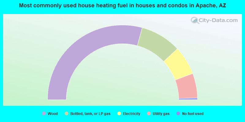
- 58.5%Wood
- 17.6%Bottled, tank, or LP gas
- 12.5%Electricity
- 10.7%Utility gas
- 0.7%No fuel used
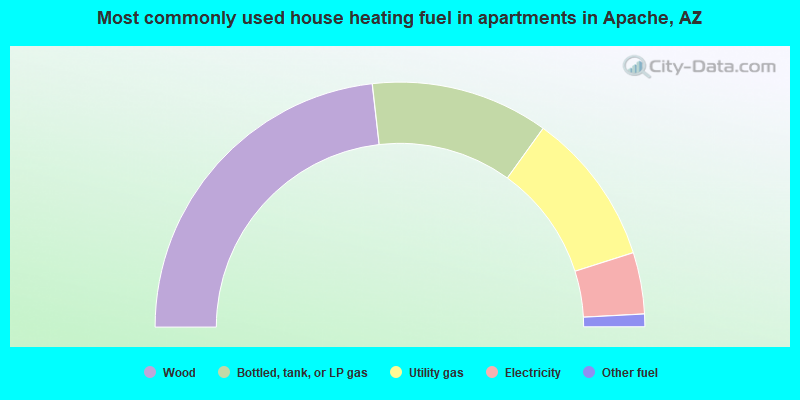
- 46.4%Wood
- 23.5%Bottled, tank, or LP gas
- 20.3%Utility gas
- 8.1%Electricity
- 1.7%Other fuel
Apache compared to Arizona state average:
- Median household income below state average.
- Median house value significantly below state average.
- Black race population percentage significantly below state average.
- Hispanic race population percentage significantly below state average.
- Median age significantly below state average.
- Foreign-born population percentage significantly below state average.
- Renting percentage significantly below state average.
- Length of stay since moving in significantly above state average.
- Number of rooms per house significantly below state average.
- House age significantly below state average.
- Institutionalized population percentage significantly above state average.
- Percentage of population with a bachelor's degree or higher significantly below state average.
Apache on our top lists:
- #1 on the list of "Top 101 cities with largest percentage of males in industries: social assistance (population 5,000+)"
- #3 on the list of "Top 101 cities with largest percentage of females in occupations: other construction workers and helpers (population 5,000+)"
- #4 on the list of "Top 101 cities with largest percentage of males in occupations: fishing and hunting, and forest and logging workers (population 5,000+)"
- #4 on the list of "Top 101 cities with largest percentage of females in occupations: other teachers and instructors, education, training, and library occupations (population 5,000+)"
- #6 on the list of "Top 101 cities with largest percentage of females in occupations: woodworkers (population 5,000+)"
- #7 on the list of "Top 101 cities with largest percentage of females in industries: wood products (population 5,000+)"
- #7 on the list of "Top 101 cities with the largest house values disparities (population 5,000+)"
- #12 on the list of "Top 101 cities with largest percentage of males in industries: wood products (population 5,000+)"
- #14 on the list of "Top 101 cities with largest percentage of males in occupations: plant and system operators (population 5,000+)"
- #17 on the list of "Top 101 cities with largest percentage of males in occupations: information and record clerks except customer service representatives (population 5,000+)"
- #27 on the list of "Top 101 cities with the lowest percentage of workers working at home, population 5,000+"
- #36 on the list of "Top 101 cities with largest percentage of males in industries: farm product raw materials merchant wholesalers (population 5,000+)"
- #43 on the list of "Top 101 cities with largest percentage of females in industries: arts, entertainment, and recreation (population 5,000+)"
- #43 on the list of "Top 101 cities with largest percentage of females in industries: warehousing and storage (population 5,000+)"
- #47 on the list of "Top 100 cities with largest land areas (pop. 5,000+)"
- #50 on the list of "Top 101 cities with largest percentage of females in industries: food and beverage stores (population 5,000+)"
- #82 on the list of "Top 101 cities with largest percentage of females in industries: social assistance (population 5,000+)"
- #92 on the list of "Top 100 least-educated cities (pop. 5,000+)"
- #21 on the list of "Top 101 counties with the largest increase in the number of deaths per 1000 residents 2000-2006 to 2007-2013 (pop. 50,000+)"
- #23 on the list of "Top 101 counties with the highest Ozone (1-hour) air pollution readings in 2012 (ppm)"