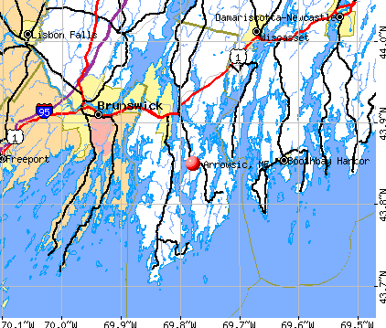
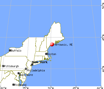
Arrowsic, Maine
Submit your own pictures of this town and show them to the world
- OSM Map
- General Map
- Google Map
- MSN Map
Population change since 2000: -10.5%
 |
| Males: 210 | |
| Females: 217 |
| Median resident age: | 55.0 years |
| Maine median age: | 43.0 years |
Zip codes: 04530.
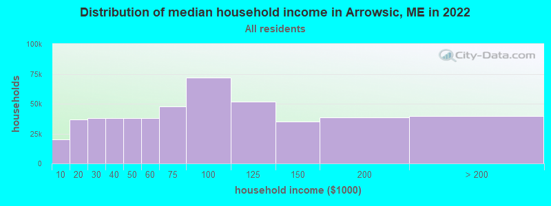
| Arrowsic: | $100,457 |
| ME: | $69,543 |
Estimated per capita income in 2022: $61,677 (it was $29,597 in 2000)
Arrowsic town income, earnings, and wages data
Estimated median house or condo value in 2022: $426,899 (it was $145,400 in 2000)
| Arrowsic: | $426,899 |
| ME: | $290,600 |
Mean prices in 2022: all housing units: $359,191; detached houses: $377,995; townhouses or other attached units: $306,259; in 2-unit structures: $363,404; in 3-to-4-unit structures: $296,417; in 5-or-more-unit structures: $457,842; mobile homes: $167,878


- 42198.6%White alone
- 30.7%American Indian alone
- 20.5%Asian alone
- 10.2%Two or more races

Races in Arrowsic detailed stats: ancestries, foreign born residents, place of birth
According to our research of Maine and other state lists, there were 2 registered sex offenders living in Arrowsic, Maine as of April 25, 2024.
The ratio of all residents to sex offenders in Arrowsic is 214 to 1.
 Recent articles from our blog. Our writers, many of them Ph.D. graduates or candidates, create easy-to-read articles on a wide variety of topics.


 | Well, here goes. The start to our trek North to Maine, our new home-state. (395 replies) |
| Retiring/"Second Act"--need add'l moving to Maine info! (20 replies) |
| Moving to Bath area (with children) (13 replies) |
| Arrowsic/Georgetown vs. Harpswell (10 replies) |
| Question about rural Maine (1 reply) |
| Rockland, Camden, Rockport or Belfast for summer vacation? (38 replies) |
Latest news from Arrowsic, ME collected exclusively by city-data.com from local newspapers, TV, and radio stations
Ancestries: English (28.1%), Irish (17.8%), German (12.2%), French (10.1%), Scottish (8.6%), French Canadian (6.3%).
Current Local Time: EST time zone
Incorporated on 03/02/1841
Elevation: 41 feet
Land area: 7.78 square miles.
Population density: 55 people per square mile (very low).
14 residents are foreign born (1.9% Europe, 0.6% Africa, 0.4% North America).
| This town: | 2.9% |
| Maine: | 2.9% |
| Arrowsic town: | 0.8% ($1,200) |
| Maine: | 1.5% ($1,417) |
Nearest city with pop. 50,000+: Portland, ME  (28.0 miles , pop. 64,249).
Nearest city with pop. 200,000+: Boston, MA (125.8 miles , pop. 589,141).
Nearest city with pop. 1,000,000+: Bronx, NY (295.6 miles , pop. 1,332,650).
Nearest cities:
), ), ), )Latitude: 43.87 N, Longitude: 69.79 W
Area code commonly used in this area: 207

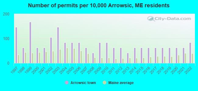
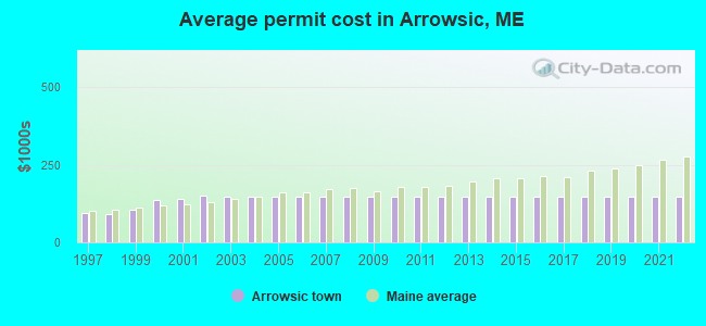
Single-family new house construction building permits:
- 2022: 4 buildings, average cost: $149,400
- 2021: 3 buildings, average cost: $149,400
- 2020: 3 buildings, average cost: $149,400
- 2019: 3 buildings, average cost: $149,400
- 2018: 3 buildings, average cost: $149,400
- 2017: 3 buildings, average cost: $149,400
- 2016: 3 buildings, average cost: $149,400
- 2015: 3 buildings, average cost: $149,400
- 2014: 3 buildings, average cost: $149,400
- 2013: 2 buildings, average cost: $149,400
- 2012: 3 buildings, average cost: $149,400
- 2011: 3 buildings, average cost: $149,400
- 2010: 4 buildings, average cost: $149,400
- 2009: 4 buildings, average cost: $149,400
- 2008: 2 buildings, average cost: $149,400
- 2007: 3 buildings, average cost: $149,400
- 2006: 4 buildings, average cost: $149,400
- 2005: 4 buildings, average cost: $149,400
- 2004: 4 buildings, average cost: $149,400
- 2003: 7 buildings, average cost: $149,400
- 2002: 5 buildings, average cost: $151,000
- 2001: 3 buildings, average cost: $140,000
- 2000: 3 buildings, average cost: $136,700
- 1999: 8 buildings, average cost: $103,800
- 1998: 3 buildings, average cost: $90,300
- 1997: 7 buildings, average cost: $95,900
| Here: | 2.6% |
| Maine: | 3.4% |
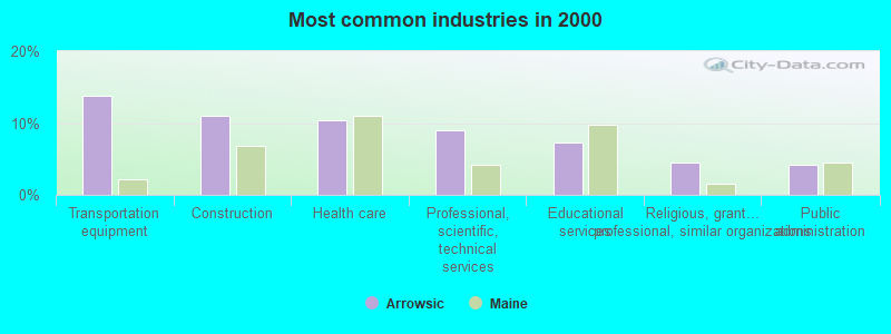
- Transportation equipment (13.8%)
- Construction (11.0%)
- Health care (10.3%)
- Professional, scientific, technical services (9.0%)
- Educational services (7.2%)
- Religious, grantmaking, civic, professional, similar organizations (4.5%)
- Public administration (4.1%)
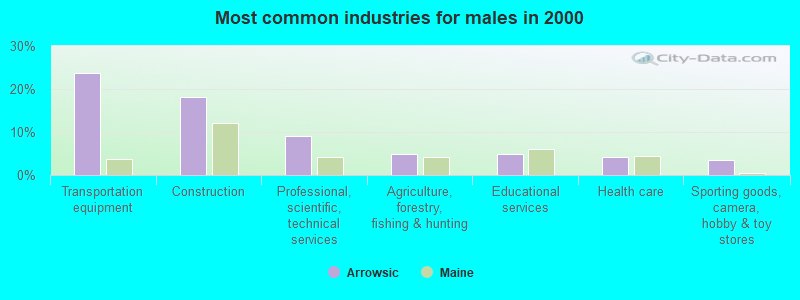
- Transportation equipment (23.6%)
- Construction (18.1%)
- Professional, scientific, technical services (9.0%)
- Agriculture, forestry, fishing & hunting (4.9%)
- Educational services (4.9%)
- Health care (4.2%)
- Sporting goods, camera, hobby & toy stores (3.5%)
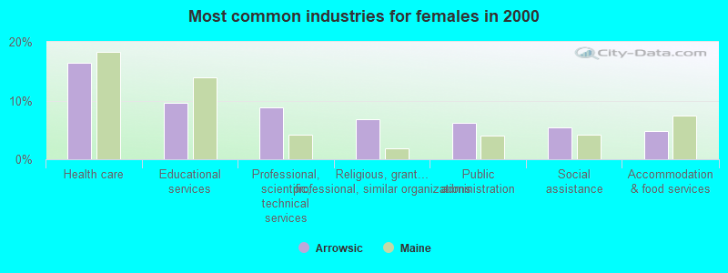
- Health care (16.4%)
- Educational services (9.6%)
- Professional, scientific, technical services (8.9%)
- Religious, grantmaking, civic, professional, similar organizations (6.8%)
- Public administration (6.2%)
- Social assistance (5.5%)
- Accommodation & food services (4.8%)
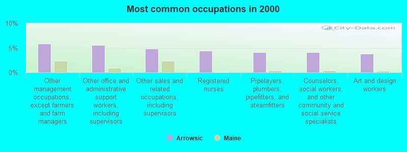
- Other management occupations, except farmers and farm managers (5.9%)
- Other office and administrative support workers, including supervisors (5.5%)
- Other sales and related occupations, including supervisors (4.8%)
- Registered nurses (4.5%)
- Pipelayers, plumbers, pipefitters, and steamfitters (4.1%)
- Counselors, social workers, and other community and social service specialists (4.1%)
- Art and design workers (3.8%)
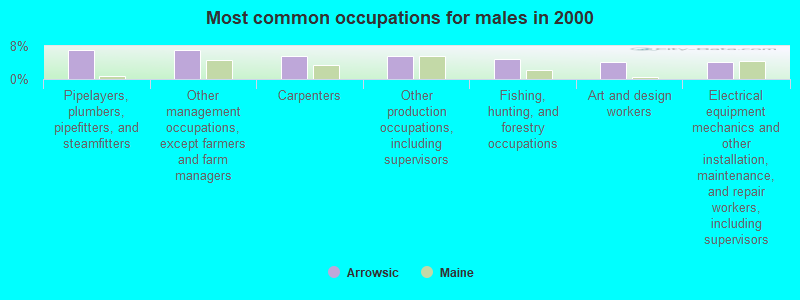
- Pipelayers, plumbers, pipefitters, and steamfitters (6.9%)
- Other management occupations, except farmers and farm managers (6.9%)
- Carpenters (5.6%)
- Other production occupations, including supervisors (5.6%)
- Fishing, hunting, and forestry occupations (4.9%)
- Art and design workers (4.2%)
- Electrical equipment mechanics and other installation, maintenance, and repair workers, including supervisors (4.2%)

- Registered nurses (8.9%)
- Other office and administrative support workers, including supervisors (8.2%)
- Counselors, social workers, and other community and social service specialists (8.2%)
- Other sales and related occupations, including supervisors (6.8%)
- Secretaries and administrative assistants (5.5%)
- Other management occupations, except farmers and farm managers (4.8%)
- Retail sales workers, except cashiers (3.4%)
Average climate in Arrowsic, Maine
Based on data reported by over 4,000 weather stations


(lower is better)
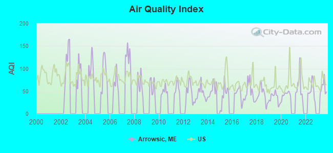
Air Quality Index (AQI) level in 2023 was 57.8. This is better than average.
| City: | 57.8 |
| U.S.: | 72.6 |
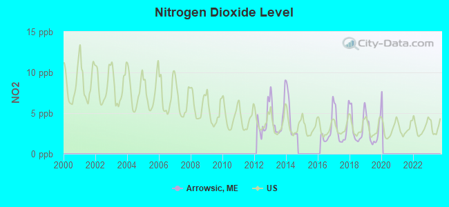
Nitrogen Dioxide (NO2) [ppb] level in 2019 was 2.80. This is significantly better than average. Closest monitor was 24.8 miles away from the city center.
| City: | 2.80 |
| U.S.: | 5.11 |
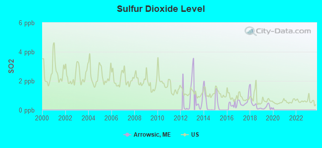
Sulfur Dioxide (SO2) [ppb] level in 2019 was 0.185. This is significantly better than average. Closest monitor was 3.3 miles away from the city center.
| City: | 0.185 |
| U.S.: | 1.515 |

Ozone [ppb] level in 2023 was 32.2. This is about average. Closest monitor was 6.1 miles away from the city center.
| City: | 32.2 |
| U.S.: | 33.3 |
Earthquake activity:
Arrowsic-area historical earthquake activity is significantly above Maine state average. It is 76% smaller than the overall U.S. average.On 10/16/2012 at 23:12:25, a magnitude 4.7 (4.7 ML, Depth: 10.0 mi, Class: Light, Intensity: IV - V) earthquake occurred 47.4 miles away from the city center
On 4/20/2002 at 10:50:47, a magnitude 5.3 (5.3 ML, Depth: 3.0 mi, Class: Moderate, Intensity: VI - VII) earthquake occurred 198.9 miles away from Arrowsic center
On 1/19/1982 at 00:14:42, a magnitude 4.7 (4.5 MB, 4.7 MD, 4.5 LG) earthquake occurred 94.3 miles away from the city center
On 4/20/2002 at 10:50:47, a magnitude 5.2 (5.2 MB, 4.2 MS, 5.2 MW, 5.0 MW) earthquake occurred 199.6 miles away from the city center
On 10/7/1983 at 10:18:46, a magnitude 5.3 (5.1 MB, 5.3 LG, 5.1 ML) earthquake occurred 227.0 miles away from Arrowsic center
On 2/26/1999 at 03:38:43, a magnitude 3.8 (3.8 LG, Depth: 2.0 mi, Class: Light, Intensity: II - III) earthquake occurred 44.1 miles away from the city center
Magnitude types: regional Lg-wave magnitude (LG), body-wave magnitude (MB), duration magnitude (MD), local magnitude (ML), surface-wave magnitude (MS), moment magnitude (MW)
Natural disasters:
The number of natural disasters in Sagadahoc County (19) is greater than the US average (15).Major Disasters (Presidential) Declared: 14
Emergencies Declared: 4
Causes of natural disasters: Floods: 12, Storms: 10, Winter Storms: 6, Hurricanes: 2, Snows: 2, Blizzard: 1, Ice Storm: 1, Snowfall: 1, Snowstorm: 1, Wind: 1, Other: 1 (Note: some incidents may be assigned to more than one category).

Hospitals and medical centers near Arrowsic:
- COASTAL DIALYSIS CENTER (Dialysis Facility, about 4 miles away; BATH, ME)
- WINSHIP GREEN NURSING CENTER (Nursing Home, about 5 miles away; BATH, ME)
- ST ANDREWS HOME HEALTH (Home Health Center, about 8 miles away; BOOTHBAY HARBOR, ME)
- ST ANDREWS HOSPITAL (LINCOLN COUNTY HEALTHCARE) Critical Access Hospitals (about 8 miles away; BOOTHBAY HARBOR, ME)
- DIONNE COMMONS (Nursing Home, about 10 miles away; BRUNSWICK, ME)
- HORIZONS LIVING AND REHAB CENTER (Nursing Home, about 10 miles away; BRUNSWICK, ME)
- COMMUNITY HEALTH AND NURSING SERVICES (Home Health Center, about 10 miles away; BRUNSWICK, ME)
Colleges/universities with over 2000 students nearest to Arrowsic:
- Southern Maine Community College (about 27 miles; South Portland, ME; Full-time enrollment: 4,666)
- University of Southern Maine (about 29 miles; Portland, ME; FT enrollment: 6,647)
- University of Maine at Augusta (about 33 miles; Augusta, ME; FT enrollment: 3,204)
- Saint Joseph's College of Maine (about 35 miles; Standish, ME; FT enrollment: 2,010)
- University of New England (about 42 miles; Biddeford, ME; FT enrollment: 4,539)
- University of Maine at Farmington (about 58 miles; Farmington, ME; FT enrollment: 2,036)
- University of New Hampshire-Main Campus (about 77 miles; Durham, NH; FT enrollment: 15,243)
Points of interest:
Notable locations in Arrowsic: Doubling Point Light Station (A), Kennebec River Light Station (B). Display/hide their locations on the map
Lake: Sewell Pond (A). Display/hide its location on the map
Creeks: Sewell Creek (A), Minot Creek (B), Newtown Creek (C). Display/hide their locations on the map
Drinking water stations with addresses in Arrowsic and their reported violations in the past:
POPHAM BEACH CLUB (Population served: 25, Groundwater):Past health violations:Past monitoring violations:
- MCL, Monthly (TCR) - In AUG-2010, Contaminant: Coliform. Follow-up actions: St Public Notif requested (AUG-26-2010), St Formal NOV issued (AUG-26-2010), St Compliance achieved (SEP-27-2010)
- 6 routine major monitoring violations
- One minor monitoring violation
| This town: | 2.1 people |
| Maine: | 2.3 people |
| This town: | 62.3% |
| Whole state: | 62.9% |
| This town: | 7.8% |
| Whole state: | 9.4% |
Likely homosexual households (counted as self-reported same-sex unmarried-partner households)
- Lesbian couples: 1.5% of all households
- Gay men: 0.0% of all households
| This town: | 1.2% |
| Whole state: | 10.9% |
| This town: | 0.8% |
| Whole state: | 4.1% |
For population 15 years and over in Arrowsic:
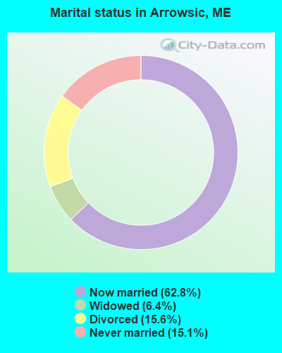
- Never married: 15.1%
- Now married: 62.8%
- Separated: 0.0%
- Widowed: 6.4%
- Divorced: 15.6%
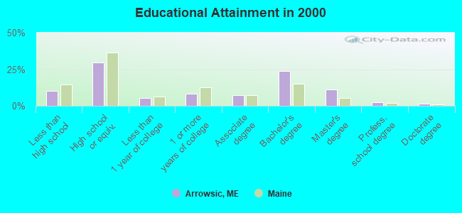
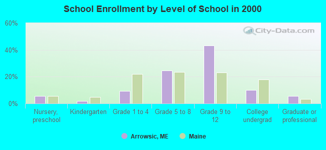
For population 25 years and over in Arrowsic:
- High school or higher: 89.6%
- Bachelor's degree or higher: 38.9%
- Graduate or professional degree: 15.3%
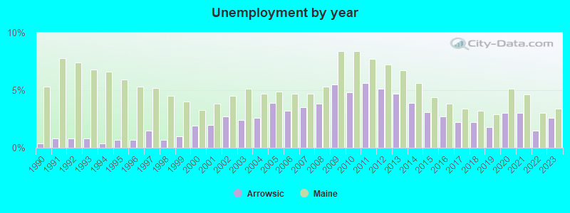
- Unemployed: 3.0%
- Mean travel time to work (commute): 25.4 minutes
| Here: | 11.8 |
| Maine average: | 11.2 |
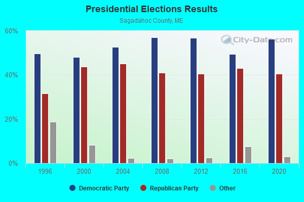
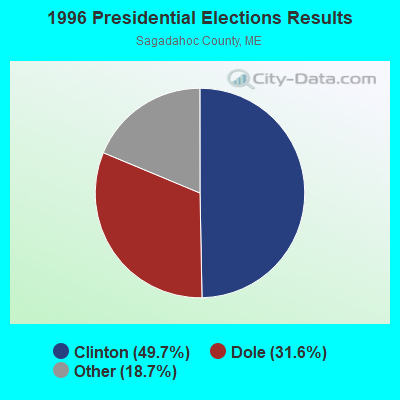
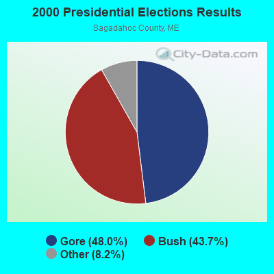
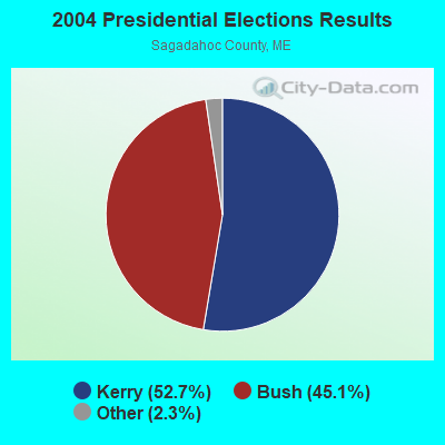

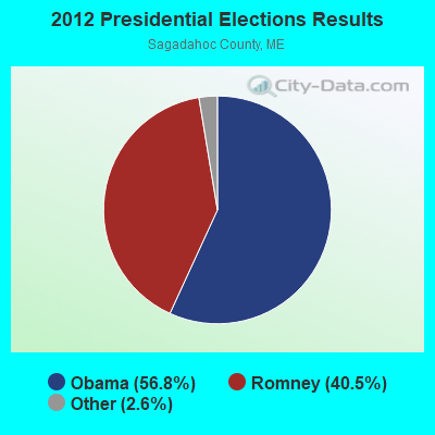
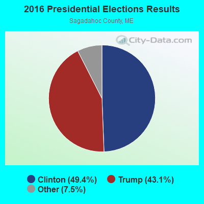
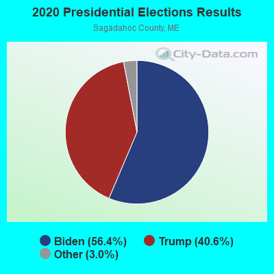
Graphs represent county-level data. Detailed 2008 Election Results
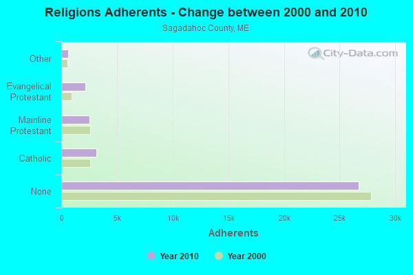
Religion statistics for Arrowsic, ME (based on Sagadahoc County data)
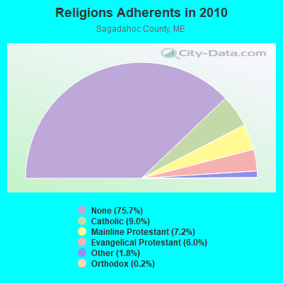
| Religion | Adherents | Congregations |
|---|---|---|
| Catholic | 3,177 | 3 |
| Mainline Protestant | 2,527 | 15 |
| Evangelical Protestant | 2,134 | 20 |
| Other | 646 | 2 |
| Orthodox | 88 | 1 |
| None | 26,721 | - |
Food Environment Statistics:
| Sagadahoc County: | 1.65 / 10,000 pop. |
| Maine: | 2.80 / 10,000 pop. |
| Sagadahoc County: | 1.93 / 10,000 pop. |
| Maine: | 2.20 / 10,000 pop. |
| Sagadahoc County: | 4.40 / 10,000 pop. |
| State: | 5.75 / 10,000 pop. |
| Here: | 10.18 / 10,000 pop. |
| State: | 11.02 / 10,000 pop. |
| This county: | 7.7% |
| Maine: | 8.2% |
| Sagadahoc County: | 26.5% |
| Maine: | 25.0% |
Strongest AM radio stations in Arrowsic:
- WJTO (730 AM; 1 kW; BATH, ME; Owner: BLUE JEY BROADCASTING COMPANY)
- WGAN (560 AM; 5 kW; PORTLAND, ME; Owner: SAGA COMMUNICATIONS OF NEW ENGLAND, LLC)
- WJJB (900 AM; 1 kW; BRUNSWICK, ME; Owner: ATLANTIC COAST RADIO, LLC)
- WMTW (870 AM; 10 kW; GORHAM, ME; Owner: RADIO PARTNERS OF MAINE, L.P.)
- WFAU (1280 AM; 5 kW; GARDINER, ME; Owner: CAPSTAR TX LIMITED PARTNERSHIP)
- WLAM (1470 AM; 5 kW; LEWISTON, ME; Owner: RADIO PARTNERS OF MAINE, L.P.)
- WRKO (680 AM; 50 kW; BOSTON, MA; Owner: ENTERCOM BOSTON LICENSE, LLC)
- WZAN (970 AM; 5 kW; PORTLAND, ME; Owner: SAGA COMMUNICATIONS OF NEW ENGLAND, LLC)
- WLOB (1310 AM; 5 kW; PORTLAND, ME; Owner: ATLANTIC COAST RADIO, LLC)
- WTME (780 AM; 10 kW; RUMFORD, ME; Owner: MOUNTAIN VALLEY BROADCASTING, INC.)
- WJAE (1440 AM; 5 kW; WESTBROOK, ME; Owner: ALTANTIC COAST RADIO, LLC)
- WEEI (850 AM; 50 kW; BOSTON, MA; Owner: ENTERCOM BOSTON LICENSE, LLC)
- WBZ (1030 AM; 50 kW; BOSTON, MA; Owner: INFINITY BROADCASTING OPERATIONS, INC.)
Strongest FM radio stations in Arrowsic:
- WCLZ (98.9 FM; BRUNSWICK, ME; Owner: CITADEL BROADCASTING COMPANY)
- WJJB-FM (95.5 FM; TOPSHAM, ME; Owner: ATLANTIC COAST RADIO, LLC)
- WBCI (105.9 FM; BATH, ME; Owner: BLOUNT COMMUNICATIONS, INC.)
- WBLM (102.9 FM; PORTLAND, ME; Owner: CITADEL BROADCASTING COMPANY)
- WTHT (107.5 FM; LEWISTON, ME; Owner: RADIO PARTNERS OF MAINE, L.P.)
- WMEA (90.1 FM; PORTLAND, ME; Owner: MAINE PUBLIC BROADCASTING CORPORATION)
- WCME (96.7 FM; BOOTHBAY HARBOR, ME; Owner: CAPSTAR TX LIMITED PARTNERSHIP)
- WPKQ (103.7 FM; NORTH CONWAY, NH; Owner: CITADEL BROADCASTING COMPANY)
- WJBQ (97.9 FM; PORTLAND, ME; Owner: CITADEL BROADCASTING COMPANY)
- WHOM (94.9 FM; MT. WASHINGTON, NH; Owner: CITADEL BROADCASTING COMPANY)
- WCYI (93.9 FM; LEWISTON, ME; Owner: CITADEL BROADCASTING COMPANY)
- WYFP (91.9 FM; HARPSWELL, ME; Owner: BIBLE BROADCASTING NETWORK, INC.)
- WMEP (90.5 FM; CAMDEN, ME; Owner: MAINE PUBLIC BROADCASTING CORP.)
- WQSS (102.5 FM; CAMDEN, ME; Owner: CLEAR CHANNEL BROADCASTING LICENSES, INC.)
- WMEK-FM (99.9 FM; AUBURN, ME; Owner: RADIO PARTNERS OF MAINE, L.P.)
- WMTW-FM (106.7 FM; NORTH WINDHAM, ME; Owner: RADIO PARTNERS OF MAINE, L.P.)
- WPOR (101.9 FM; PORTLAND, ME; Owner: SAGA COMMUNICATIONS OF NEW ENGLAND, LLC)
- WYNZ (100.9 FM; WESTBROOK, ME; Owner: SAGA COMMUNICATIONS OF NEW ENGLAND, LLC)
- WMCM (103.3 FM; ROCKLAND, ME; Owner: CLEAR CHANNEL BROADCASTING LICENSES, INC.)
- WMSJ (89.3 FM; FREEPORT, ME; Owner: DOWNEAST CHRISTIAN COMMUNICATIONS)
TV broadcast stations around Arrowsic:
- WGME-TV (Channel 13; PORTLAND, ME; Owner: WGME LICENSEE, LLC)
- WPFO (Channel 23; WATERVILLE, ME; Owner: CMCG PORTLAND LICENSE LLC)
- WMTW-TV (Channel 8; POLAND SPRING, ME; Owner: WMTW BROADCAST GROUP, LLC)
- WCBB (Channel 10; AUGUSTA, ME; Owner: MAINE PUBLIC BROADCASTING CORP.)
- WPXT (Channel 51; PORTLAND, ME; Owner: HMW, INC.)
- WPME (Channel 35; LEWISTON, ME; Owner: KB PRIME MEDIA LLC)
- WCSH (Channel 6; PORTLAND, ME; Owner: PACIFIC AND SOUTHERN COMPANY, INC.)
- W32CA (Channel 32; PORTLAND, ME; Owner: NATIONAL MINORITY T.V., INC.)
- W29CA (Channel 29; BRUNSWICK, ME; Owner: CRAIG MINISTRIES)
Arrowsic fatal accident list:
- National Bridge Inventory (NBI) Statistics
- 3Number of bridges
- 128ft / 39.1mTotal length
- 6,064Total average daily traffic
- 302Total average daily truck traffic
- 8,580Total future (year 2036) average daily traffic
FCC Registered Amateur Radio Licenses:
7- Call Sign: K1VHF, Licensee ID: L00234869, Grant Date: 02/01/2022, Expiration Date: 03/31/2032, Certifier: Morton H Krantz, Registrant: Morton H Krantz, 11 Birch Landing Rd, Arrowsic, ME 04530
- Call Sign: K8SH, Licensee ID: L00586814, Grant Date: 02/14/2023, Expiration Date: 02/23/2033, Registrant: Christopher P Hanson, 262 Bald Head Road, Arrowsic, ME 04530
- Call Sign: N1PL, Licensee ID: L00392128, Grant Date: 08/18/2022, Expiration Date: 09/01/2032, Certifier: Paul Kalkstein, Registrant: Paul Kalkstein, 42 Doubling Point Rd, Arrowsic, ME 04530
- Call Sign: W1FPZ, Licensee ID: L01348791, Grant Date: 12/07/2007, Expiration Date: 10/24/2017, Cancellation Date: 10/25/2019, Certifier: John F Rollins, Registrant: John F Rollins, 21 Bald Head Road, Arrowsic, ME 04530
- Call Sign: KB1OWC, Licensee ID: L01268026, Grant Date: 03/08/2017, Expiration Date: 04/11/2027, Certifier: John L White Sr, Registrant: John L White Sr, 46 Arrowsic Rd, Arrowsic, ME 04530
- Call Sign: KB1SCV, Licensee ID: L01480008, Grant Date: 04/02/2009, Expiration Date: 04/02/2019, Cancellation Date: 04/03/2021, Certifier: Heather K Baker, Registrant: Heather K Baker, 12 Sirois Rd, Arrowsic, ME 04530
- Call Sign: KB1SYT, Licensee ID: L01518725, Grant Date: 09/17/2009, Expiration Date: 09/17/2019, Cancellation Date: 09/18/2021, Certifier: Kip Stone, Registrant: Kip Stone, 461 Bald Head Rd, Arrowsic, ME 04530
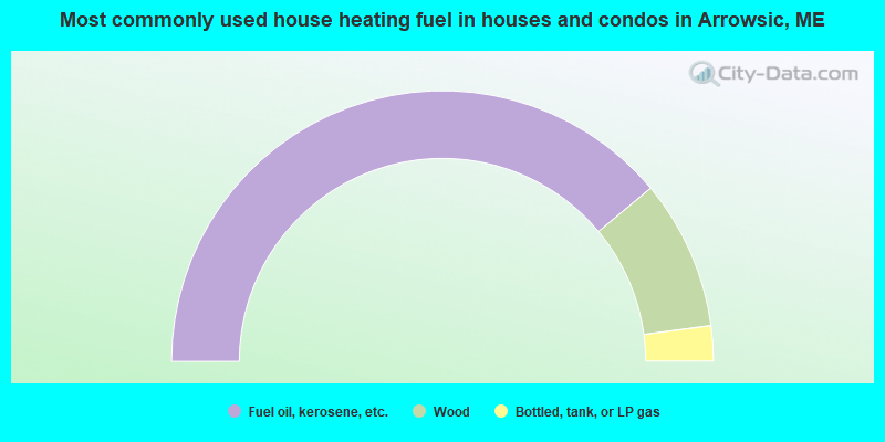
- 77.9%Fuel oil, kerosene, etc.
- 17.9%Wood
- 4.2%Bottled, tank, or LP gas
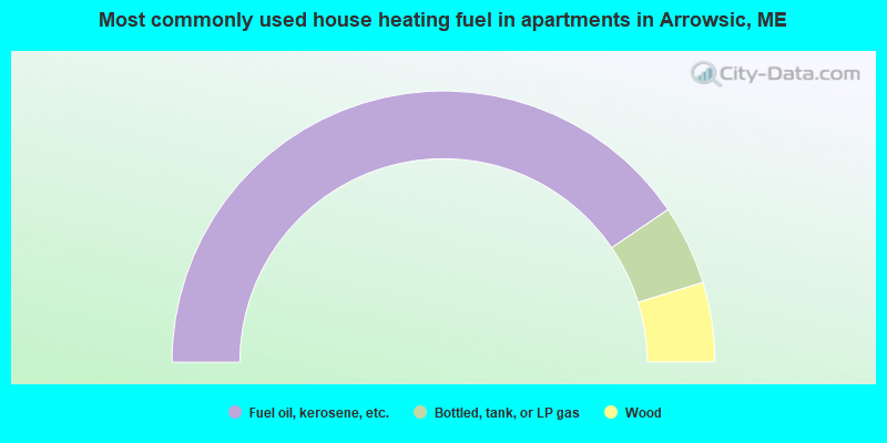
- 81.0%Fuel oil, kerosene, etc.
- 9.5%Bottled, tank, or LP gas
- 9.5%Wood
Arrowsic compared to Maine state average:
- Unemployed percentage significantly below state average.
- Black race population percentage significantly below state average.
- Hispanic race population percentage significantly below state average.
- Median age significantly above state average.
- Renting percentage significantly below state average.
- Length of stay since moving in significantly above state average.
- Number of rooms per house significantly below state average.
- House age significantly below state average.

|
Total of 3 patent applications in 2008-2024.