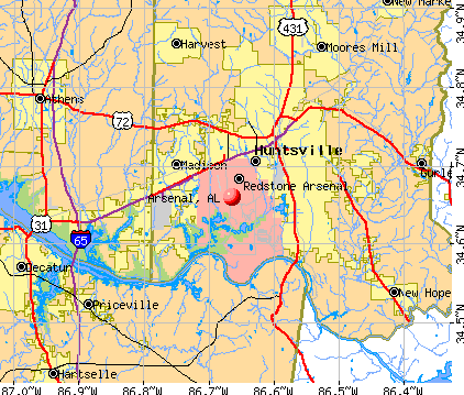
Arsenal, Alabama
Submit your own pictures of this place and show them to the world
- OSM Map
- General Map
- Google Map
- MSN Map
| Males: 1,607 | |
| Females: 1,068 |
| Median resident age: | 23.9 years |
| Alabama median age: | 35.8 years |
Zip code: 35808
| Arsenal: | $63,510 |
| AL: | $59,674 |
Estimated per capita income in 2022: $29,560 (it was $14,860 in 2000)
Arsenal CCD income, earnings, and wages data
Estimated median house or condo value in 2022: $338,072 (it was $112,500 in 2000)
| Arsenal: | $338,072 |
| AL: | $200,900 |
Mean prices in 2022: all housing units: $359,078; detached houses: $372,826; townhouses or other attached units: $229,990; in 3-to-4-unit structures: $148,927; in 5-or-more-unit structures: $174,592; mobile homes: $80,916; occupied boats, rvs, vans, etc.: $55,000
Detailed information about poverty and poor residents in Arsenal, AL


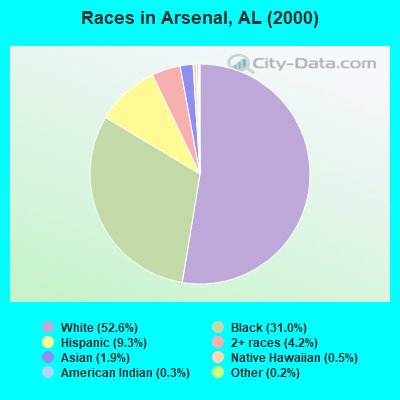
- 1,24552.6%White alone
- 73431.0%Black alone
- 2209.3%Hispanic
- 1004.2%Two or more races
- 451.9%Asian alone
- 120.5%Native Hawaiian and Other
Pacific Islander alone - 80.3%American Indian alone
- 50.2%Other race alone
 Recent articles from our blog. Our writers, many of them Ph.D. graduates or candidates, create easy-to-read articles on a wide variety of topics.

Current Local Time: CST time zone
Land area: 60.3 square miles.
Population density: 44 people per square mile (very low).

| Arsenal CCD: | 0.0% ($0) |
| Alabama: | 0.4% ($289) |
Nearest city with pop. 50,000+: Huntsville, AL  (5.3 miles , pop. 158,216).
Nearest city with pop. 200,000+: Birmingham, AL (79.0 miles , pop. 242,820).
Nearest city with pop. 1,000,000+: Chicago, IL (499.7 miles , pop. 2,896,016).
Nearest cities:
), ), ), ), Latitude: 34.66 N, Longitude: 86.66 W
Area code commonly used in this area: 256

| Here: | 2.2% |
| Alabama: | 2.6% |
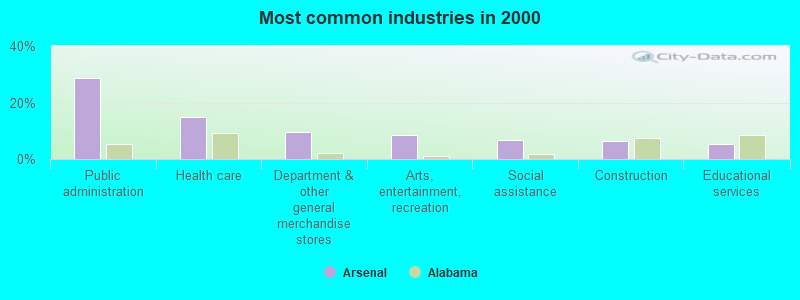
- Public administration (28.8%)
- Health care (15.0%)
- Department & other general merchandise stores (9.7%)
- Arts, entertainment, recreation (8.4%)
- Social assistance (6.9%)
- Construction (6.2%)
- Educational services (5.3%)
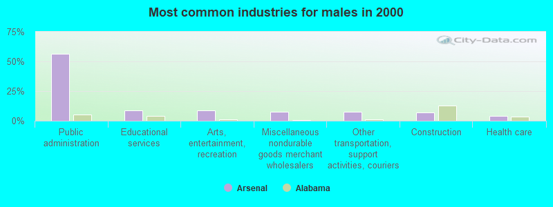
- Public administration (56.4%)
- Educational services (8.5%)
- Arts, entertainment, recreation (8.5%)
- Miscellaneous nondurable goods merchant wholesalers (7.7%)
- Other transportation, support activities, couriers (7.7%)
- Construction (6.8%)
- Health care (4.3%)
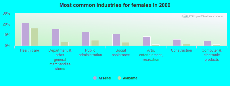
- Health care (21.2%)
- Department & other general merchandise stores (15.3%)
- Public administration (12.8%)
- Social assistance (10.8%)
- Arts, entertainment, recreation (8.4%)
- Construction (5.9%)
- Computer & electronic products (4.4%)
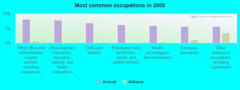
- Other office and administrative support workers, including supervisors (8.1%)
- Other teachers, instructors, education, training, and library occupations (7.8%)
- Child care workers (6.9%)
- Entertainers and performers, sports, and related workers (6.2%)
- Health technologists and technicians (5.9%)
- Computer specialists (5.6%)
- Other production occupations, including supervisors (5.6%)
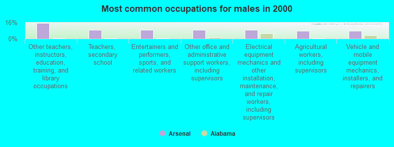
- Other teachers, instructors, education, training, and library occupations (15.4%)
- Teachers, secondary school (8.5%)
- Entertainers and performers, sports, and related workers (8.5%)
- Other office and administrative support workers, including supervisors (8.5%)
- Electrical equipment mechanics and other installation, maintenance, and repair workers, including supervisors (8.5%)
- Agricultural workers, including supervisors (7.7%)
- Vehicle and mobile equipment mechanics, installers, and repairers (7.7%)
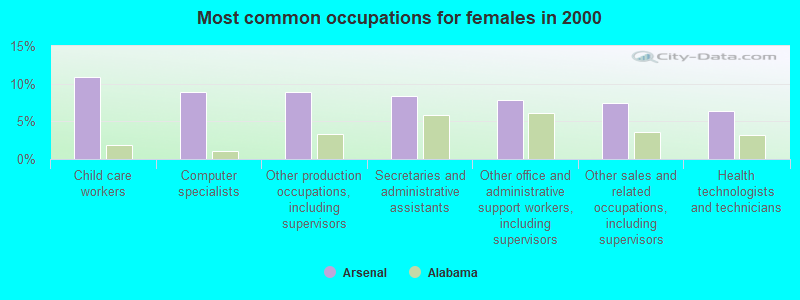
- Child care workers (10.8%)
- Computer specialists (8.9%)
- Other production occupations, including supervisors (8.9%)
- Secretaries and administrative assistants (8.4%)
- Other office and administrative support workers, including supervisors (7.9%)
- Other sales and related occupations, including supervisors (7.4%)
- Health technologists and technicians (6.4%)
Average climate in Arsenal, Alabama
Based on data reported by over 4,000 weather stations


(lower is better)
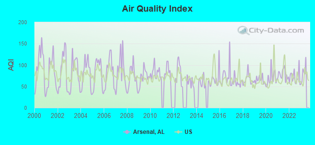
Air Quality Index (AQI) level in 2022 was 71.0. This is about average.
| City: | 71.0 |
| U.S.: | 72.6 |
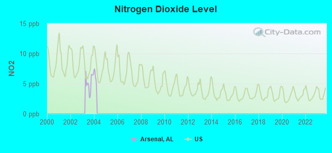
Nitrogen Dioxide (NO2) [ppb] level in 2003 was 5.26. This is about average. Closest monitor was 4.7 miles away from the city center.
| City: | 5.26 |
| U.S.: | 5.11 |
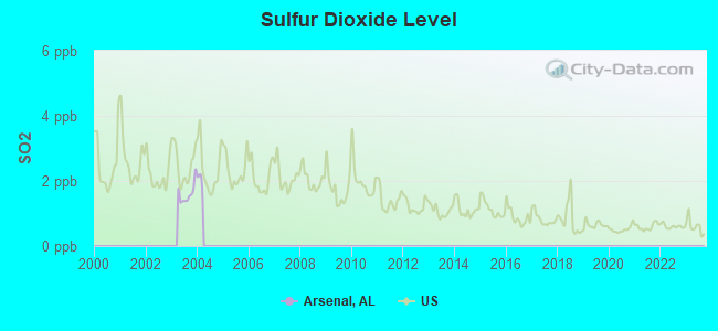
Sulfur Dioxide (SO2) [ppb] level in 2003 was 1.61. This is about average. Closest monitor was 4.7 miles away from the city center.
| City: | 1.61 |
| U.S.: | 1.51 |
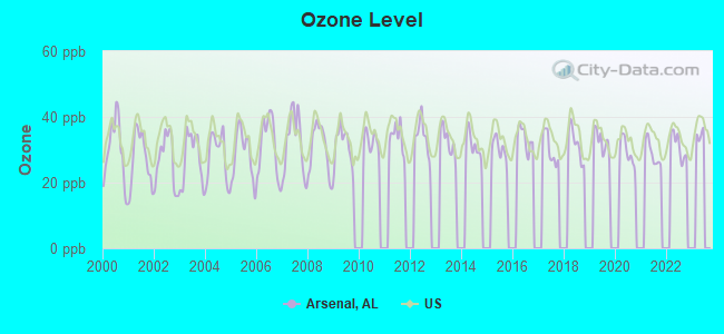
Ozone [ppb] level in 2022 was 31.2. This is about average. Closest monitor was 4.7 miles away from the city center.
| City: | 31.2 |
| U.S.: | 33.3 |
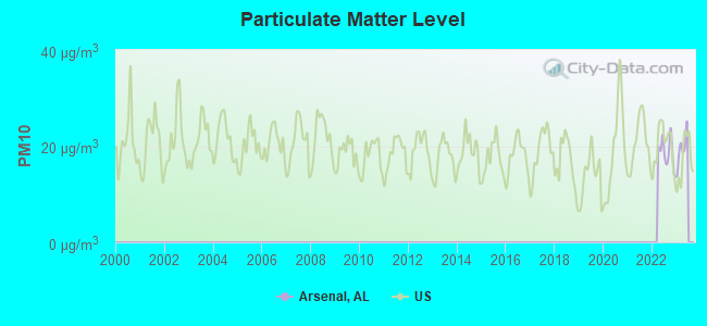
Particulate Matter (PM10) [µg/m3] level in 2022 was 18.7. This is about average. Closest monitor was 4.7 miles away from the city center.
| City: | 18.7 |
| U.S.: | 19.2 |
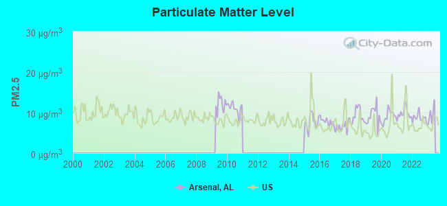
Particulate Matter (PM2.5) [µg/m3] level in 2022 was 8.69. This is about average. Closest monitor was 4.7 miles away from the city center.
| City: | 8.69 |
| U.S.: | 8.11 |
Tornado activity:
Arsenal-area historical tornado activity is slightly above Alabama state average. It is 151% greater than the overall U.S. average.
On 4/3/1974, a category F5 (max. wind speeds 261-318 mph) tornado 11.9 miles away from the Arsenal place center killed 28 people and injured 267 people.
On 4/3/1974, a category F5 tornado 22.1 miles away from the place center killed 28 people and injured 272 people.
Earthquake activity:
Arsenal-area historical earthquake activity is significantly above Alabama state average. It is 164% greater than the overall U.S. average.On 4/29/2003 at 08:59:39, a magnitude 4.9 (4.4 MB, 4.6 MW, 4.9 LG, Class: Light, Intensity: IV - V) earthquake occurred 60.1 miles away from the city center
On 1/18/1999 at 07:00:53, a magnitude 4.8 (4.8 MB, 4.0 LG, Depth: 0.6 mi) earthquake occurred 93.2 miles away from Arsenal center
On 4/29/2003 at 08:59:39, a magnitude 4.6 (4.6 MW, Depth: 12.3 mi) earthquake occurred 60.0 miles away from the city center
On 4/18/2008 at 09:36:59, a magnitude 5.4 (5.1 MB, 4.8 MS, 5.4 MW, 5.2 MW, Class: Moderate, Intensity: VI - VII) earthquake occurred 270.9 miles away from the city center
On 6/24/1975 at 11:11:36, a magnitude 4.5 (4.5 MB) earthquake occurred 93.6 miles away from Arsenal center
On 3/25/1976 at 00:41:20, a magnitude 5.0 (4.9 MB, 5.0 LG) earthquake occurred 217.9 miles away from the city center
Magnitude types: regional Lg-wave magnitude (LG), body-wave magnitude (MB), surface-wave magnitude (MS), moment magnitude (MW)
Natural disasters:
The number of natural disasters in Madison County (17) is near the US average (15).Major Disasters (Presidential) Declared: 10
Emergencies Declared: 5
Causes of natural disasters: Storms: 8, Tornadoes: 8, Floods: 6, Hurricanes: 3, Winds: 3, Drought: 1, Freeze: 1, Ice Storm: 1, Snowfall: 1, Winter Storm: 1, Other: 1 (Note: some incidents may be assigned to more than one category).
Hospitals and medical centers near Arsenal:
- AMEDISYS HOME HEALTH OF HUNTSVILLE (Home Health Center, about 4 miles away; HUNTSVILLE, AL)
- BROOKSHIRE HEALTHCARE CENTER (Nursing Home, about 5 miles away; HUNTSVILLE, AL)
- HOSPICE FAMILY CARE (Hospital, about 5 miles away; HUNTSVILLE, AL)
- HUNTSVILLE HOSPICE CARE INC (Hospital, about 5 miles away; HUNTSVILLE, AL)
- ODYSSEY HEALTHCARE OF HUNTSVILLE (Hospital, about 6 miles away; HUNTSVILLE, AL)
- HUNTSVILLE HEALTH AND REHABILITATION, LLC (Nursing Home, about 6 miles away; HUNTSVILLE, AL)
- MADISON MANOR NURSING HOME (Nursing Home, about 6 miles away; MADISON, AL)
Operable nuclear power plants near Arsenal:
- 19 miles: Browns Ferry 1 and 2 in Decatur, AL.
- 19 miles: Browns Ferry 3 in Decatur, AL.
Colleges/universities with over 2000 students nearest to Arsenal:
- University of Alabama in Huntsville (about 5 miles; Huntsville, AL; Full-time enrollment: 6,006)
- Alabama A & M University (about 11 miles; Normal, AL; FT enrollment: 4,524)
- John C Calhoun State Community College (about 17 miles; Tanner, AL; FT enrollment: 7,911)
- Athens State University (about 20 miles; Athens, AL; FT enrollment: 2,771)
- George C Wallace State Community College-Hanceville (about 42 miles; Hanceville, AL; FT enrollment: 4,486)
- Snead State Community College (about 43 miles; Boaz, AL; FT enrollment: 2,023)
- Northeast Alabama Community College (about 44 miles; Rainsville, AL; FT enrollment: 2,409)
Points of interest:
Notable locations in Arsenal: Byrd Spring Rod and Gun Club (A), Saturn V Dynamic Test Stand (B), Redstone Test Stand (C), Propulsion and Structural Test Facility (D), Neutral Buoyancy Space Simulator (E), Rapid Aerostat Initial Deployment System (RAID) (F), Redstone Arsenal Fire Station 4 (G), Redstone Arsenal Fire Station 3 (H), Redstone Arsenal Fire Station 2 (I), Redstone Arsenal Fire Station 1 (J). Display/hide their locations on the map
Shopping Center: North Park Center Shopping Center (1). Display/hide its location on the map
Churches in Arsenal include: Post Chapel (A), First Seventh Day Adventist Church (B). Display/hide their locations on the map
Cemeteries: Moore Cemetery (1), Jones Cemetery (2), Jordan Cemetery (3), Lacey Cemetery (4), Williams Cemetery (5), Lanier Cemetery (6), Lacey Cemetery (7). Display/hide their locations on the map
Lakes and reservoirs: Cribbs Pond (A), Lees Pond (B), Rock Pond (C), Swan Pond (D), Byrd Spring Lake (E). Display/hide their locations on the map
Streams, rivers, and creeks: Huntsville Spring Branch (A), McDonald Creek (B), Byrd Spring Branch (C). Display/hide their locations on the map
Park in Arsenal: Redstone Arsenal Recreation Area (1). Display/hide its location on the map
| This place: | 3.5 people |
| Alabama: | 2.5 people |
| This place: | 0.8% |
| Whole state: | 70.4% |
| This place: | 1.0% |
| Whole state: | 3.4% |
Likely homosexual households (counted as self-reported same-sex unmarried-partner households)
- Lesbian couples: 0.4% of all households
- Gay men: 0.2% of all households
| This place: | 10.4% |
| Whole state: | 16.1% |
| This place: | 6.4% |
| Whole state: | 7.3% |
85 people in wards in military hospitals for patients who have no usual home elsewhere in 2000
For population 15 years and over in Arsenal:
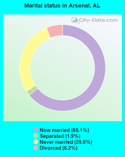
- Never married: 28.6%
- Now married: 65.1%
- Separated: 1.9%
- Widowed: 0.0%
- Divorced: 6.2%
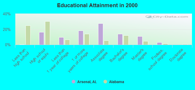
For population 25 years and over in Arsenal:
- High school or higher: 99.5%
- Bachelor's degree or higher: 27.9%
- Graduate or professional degree: 14.0%
- Unemployed: 3.9%
- Mean travel time to work (commute): 11.2 minutes
| Here: | 7.3 |
| Alabama average: | 13.2 |
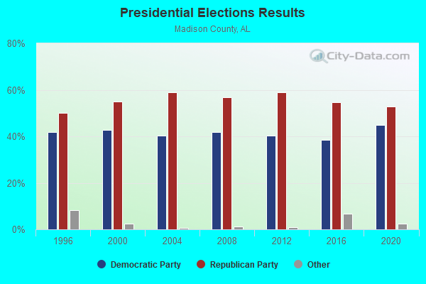
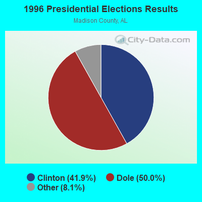
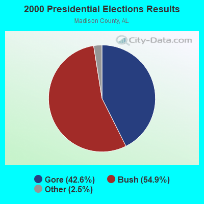
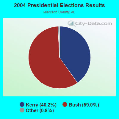

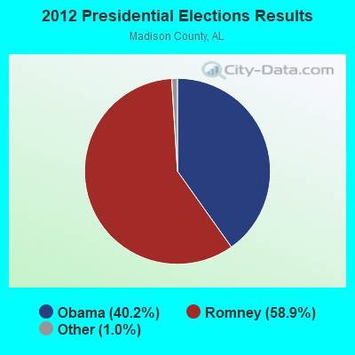

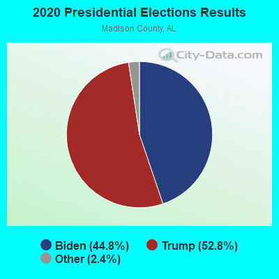
Graphs represent county-level data. Detailed 2008 Election Results
Religion statistics for Arsenal, AL (based on Madison County data)
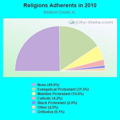
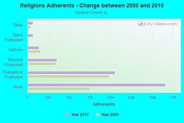
| Religion | Adherents | Congregations |
|---|---|---|
| Evangelical Protestant | 105,503 | 284 |
| Mainline Protestant | 35,533 | 72 |
| Catholic | 14,157 | 6 |
| Black Protestant | 6,710 | 41 |
| Other | 6,587 | 27 |
| Orthodox | 340 | 2 |
| None | 165,981 | - |
Food Environment Statistics:
| Madison County: | 1.12 / 10,000 pop. |
| Alabama: | 1.89 / 10,000 pop. |
| This county: | 0.29 / 10,000 pop. |
| State: | 0.20 / 10,000 pop. |
| Madison County: | 0.51 / 10,000 pop. |
| Alabama: | 0.65 / 10,000 pop. |
| Madison County: | 5.66 / 10,000 pop. |
| State: | 6.32 / 10,000 pop. |
| Here: | 6.47 / 10,000 pop. |
| State: | 5.75 / 10,000 pop. |
| This county: | 12.1% |
| Alabama: | 11.8% |
| Madison County: | 30.9% |
| Alabama: | 31.7% |
| This county: | 14.1% |
| State: | 13.5% |
7.25% of this county's 2021 resident taxpayers lived in other counties in 2020 ($73,277 average adjusted gross income)
| Here: | 7.25% |
| Alabama average: | 6.87% |
0.07% of residents moved from foreign countries ($1,008 average AGI)
Madison County: 0.07% Alabama average: 0.02%
Top counties from which taxpayers relocated into this county between 2020 and 2021:
| from Limestone County, AL | |
| from Morgan County, AL | |
| from Jefferson County, AL |
6.24% of this county's 2020 resident taxpayers moved to other counties in 2021 ($77,445 average adjusted gross income)
| Here: | 6.24% |
| Alabama average: | 6.41% |
0.04% of residents moved to foreign countries ($728 average AGI)
Madison County: 0.04% Alabama average: 0.02%
Top counties to which taxpayers relocated from this county between 2020 and 2021:
| to Limestone County, AL | |
| to Morgan County, AL | |
| to Marshall County, AL |
Strongest AM radio stations in Arsenal:
- WLOR (1550 AM; 50 kW; HUNTSVILLE, AL; Owner: BCA RADIO, LLC)
- WDJL (1000 AM; daytime; 10 kW; HUNTSVILLE, AL; Owner: JAMES K. SHARP DBA 5TH AVE BROADCASTING)
- WEUP (1600 AM; 10 kW; HUNTSVILLE, AL; Owner: HUNDLEY BATTS, SR. & VIRGINIA CAPLES)
- WEUV (1700 AM; 10 kW; HUNTSVILLE, AL; Owner: HUNDLEY BATTS, SR & VIRGINIA CAPLES)
- WUMP (730 AM; 1 kW; MADISON, AL; Owner: TENNESSEE VALLEY RADIO, INC.)
- WVNN (770 AM; 10 kW; ATHENS, AL; Owner: ATHENS BROADCASTING COMPANY, INC.)
- WBXR (1140 AM; daytime; 15 kW; HAZEL GREEN, AL; Owner: LOW COUNTRY CORPORATION, INC.)
- WBHP (1230 AM; 1 kW; HUNTSVILLE, AL; Owner: CAPSTAR TX LIMITED PARTNERSHIP)
- WTKI (1450 AM; 1 kW; HUNTSVILLE, AL; Owner: MOUNTAIN MIST MEDIA, LLC)
- WWAM (820 AM; daytime; 50 kW; JASPER, TN; Owner: SHELTON BROADCASTING SYSTEM)
- WYAM (890 AM; daytime; 2 kW; HARTSELLE, AL; Owner: DECATUR COMMUNICATIONS PROPERTIES, LLC)
- WDJC (850 AM; 50 kW; BIRMINGHAM, AL; Owner: KIMTRON, INC.)
- WNSI (810 AM; 50 kW; JACKSONVILLE, AL; Owner: UNITED BROADCASTING NETWORK, INC.)
Strongest FM radio stations in Arsenal:
- WRTT-FM (95.1 FM; HUNTSVILLE, AL; Owner: BCA RADIO, LLC)
- WAHR (99.1 FM; HUNTSVILLE, AL; Owner: BCA RADIO, LLC)
- W289AC (105.7 FM; HUNTSVILLE, AL; Owner: WILLIAM PAXTON ROGERS)
- WXQW (94.1 FM; MERIDIANVILLE, AL; Owner: CAPSTAR TX LIMITED PARTNERSHIP)
- W293AH (106.5 FM; NORMAL, AL; Owner: CAPSTAR TX LIMITED PARTNERSHIP)
- W298AF (107.5 FM; HADEN, AL; Owner: HADEN RADIO COMPANY)
- W249BB (97.7 FM; HUNTSVILLE, AL; Owner: WAY-FM MEDIA GROUP, INC.)
- W275AA (102.9 FM; HUNTSVILLE, AL; Owner: ARCHIE C. BOBO, PERSONAL REP. OF DORSEY E. NEWMAN ESTATE)
- W300AH (107.9 FM; HUNTSVILLE, AL; Owner: PORTER L. BATTS)
- W202BV (88.3 FM; HUNTSVILLE, AL; Owner: WAY-FM MEDIA GROUP, INC.)
- W222AK (92.3 FM; HUNTSVILLE, AL; Owner: PRESS W. PARHAM)
- WLRH (89.3 FM; HUNTSVILLE, AL; Owner: ALABAMA EDUCATIONAL TELEVISION COMMISSION)
- WZYP (104.3 FM; ATHENS, AL; Owner: ATHENS BROADCASTING COMPANY, INC.)
- W278AA (103.5 FM; MADISON, AL; Owner: TENNESSEE VALLEY RADIO, INC.)
- WYFD (91.7 FM; DECATUR, AL; Owner: BIBLE BROADCASTING NETWORK, INC.)
- WRSA-FM (96.9 FM; DECATUR, AL; Owner: NCA, INC.)
- WDRM (102.1 FM; DECATUR, AL; Owner: CAPSTAR TX LIMITED PARTNERSHIP)
- WAYH (88.1 FM; HARVEST, AL; Owner: WAY-FM MEDIA GROUP, INC.)
- W251AC (98.1 FM; CHAPSHAW, AL; Owner: WILLIAM PAXTON ROGERS)
- WOCG (90.1 FM; HUNTSVILLE, AL; Owner: OAKWOOD COLLEGE)
TV broadcast stations around Arsenal:
- WZDX (Channel 54; HUNTSVILLE, AL; Owner: HUNTSVILLE TELEVISION ACQUISITION CORP.)
- WAAY-TV (Channel 31; HUNTSVILLE, AL; Owner: PIEDMONT TELEVISION OF HUNTSVILLE LICENSE LLC)
- WHNT-TV (Channel 19; HUNTSVILLE, AL; Owner: NEW YORK TIMES MANAGEMENT SERVICES)
- W67CO (Channel 67; HUNTSVILLE, AL; Owner: TRINITY BROADCASTING NETWORK)
- WTZT-LP (Channel 11; ATHENS, AL; Owner: WTZT-LP TELEVISION STATION, L.L.C.)
- WHIQ (Channel 25; HUNTSVILLE, AL; Owner: ALABAMA EDUCATIONAL TELEVISION COMMISSION)
- W38BQ (Channel 38; HUNTSVILLE, AL; Owner: THREE ANGELS BROADCASTING NETWORK)
- W64BJ (Channel 64; SCOTTSBORO, AL; Owner: TRINITY BROADCASTING NETWORK)
- WYAM-LP (Channel 56; DECATUR, AL; Owner: DECATUR COMMUNICATION PROPERTIES, LLC)
- WMJN-LP (Channel 43; DECATUR, AL; Owner: FIRST CULLMAN BROADCASTING, INC.)
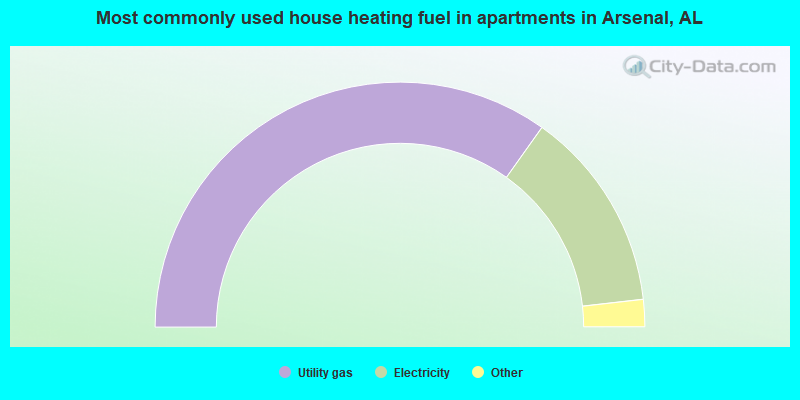
- 69.7%Utility gas
- 26.7%Electricity
- 2.2%Bottled, tank, or LP gas
- 1.4%No fuel used
Arsenal compared to Alabama state average:
- Median house value above state average.
- Unemployed percentage significantly below state average.
- Hispanic race population percentage above state average.
- Median age significantly below state average.
- Foreign-born population percentage significantly below state average.
- Renting percentage significantly below state average.
- Length of stay since moving in significantly above state average.
- Number of rooms per house significantly below state average.
- House age significantly below state average.
- Institutionalized population percentage significantly above state average.
Arsenal on our top lists:
- #1 on the list of "Top 101 cities with the lowest percentage of family households, population 1,000+"
- #4 on the list of "Top 101 cities with the largest percentage of people in wards in military hospitals for patients who have no usual home elsewhere (population 1,000+)"
- #35 on the list of "Top 101 cities with the largest percentage of people in military barracks, etc. (population 1,000+)"
- #95 (35808) on the list of "Top 101 zip codes with the smallest percentage of taxpayers using paid preparers for 2012 taxes (pop 1,000+)"
- #40 on the list of "Top 101 counties with the highest number of infant deaths per 1000 residents 2007-2013 (pop. 50,000+)"
- #66 on the list of "Top 101 counties with the most Evangelical Protestant adherents"
- #82 on the list of "Top 101 counties with the highest ground withdrawal of fresh water for public supply"
- #83 on the list of "Top 101 counties with the most Black Protestant congregations"
- #83 on the list of "Top 101 counties with the most Evangelical Protestant congregations"