Autaugaville, Alabama
Submit your own pictures of this town and show them to the world
- OSM Map
- General Map
- Google Map
- MSN Map
Population change since 2000: -2.7%
 |
| Males: 439 | |
| Females: 359 |
| Median resident age: | 35.0 years |
| Alabama median age: | 39.6 years |
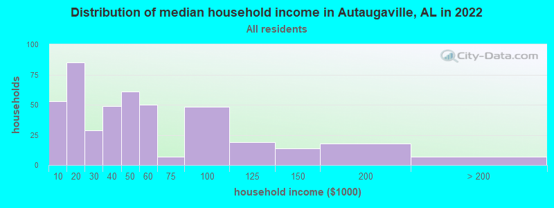
| Autaugaville: | $41,652 |
| AL: | $59,674 |
Estimated per capita income in 2022: $26,600 (it was $12,586 in 2000)
Autaugaville town income, earnings, and wages data
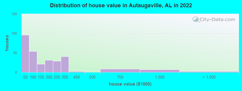
Estimated median house or condo value in 2022: $120,383 (it was $38,200 in 2000)
| Autaugaville: | $120,383 |
| AL: | $200,900 |
Mean prices in 2022: all housing units: $212,540; detached houses: $379,245; mobile homes: $56,919; occupied boats, rvs, vans, etc.: $230,132
Median gross rent in 2022: $444.
(2.8% for White Non-Hispanic residents, 29.6% for Black residents)
Detailed information about poverty and poor residents in Autaugaville, AL
Compare current foreclosures near Autaugaville, AL:
| Photo | Address | Area | Beds / Baths | Price | Details |
|---|---|---|---|---|---|

|
#1
Shiloh Cir
Autaugaville, AL 36003
|
968 sq. feet
|
1 baths - beds |
show details | |

|
#2
Shiloh Dr
Autaugaville, AL 36003
|
960 sq. feet
|
1 baths - beds |
show details | |

|
#3
T R Dr
Autaugaville, AL 36003
|
1,152 sq. feet
|
2 baths - beds |
show details | |

|
#4
Cyrus Dr
Autaugaville, AL 36003
|
978 sq. feet
|
1 baths - beds |
show details | |

|
#5
Frazer Ln
Autaugaville, AL 36003
|
1,269 sq. feet
|
2 baths - beds |
show details | |

|
#6
County Road 2
Autaugaville, AL 36003
|
- sq. feet
|
- baths - beds |
show details | |

|
#7
Dutch Bend St Lot 1
Autaugaville, AL 36003
|
- sq. feet
|
- baths - beds |
show details | |

|
#8
Strickland Landing Rd
Autaugaville, AL 36003
|
- sq. feet
|
- baths - beds |
show details | |

|
#9
Shiloh Cir
Autaugaville, AL 36003
|
- sq. feet
|
- baths - beds |
show details | |

|
#10
S Autauga St # B
Autaugaville, AL 36003
|
- sq. feet
|
1 baths - beds |
show details |
| Photo | Address | Area | Beds / Baths | Price | Details |
|---|---|---|---|---|---|

|
#11
County Road 9 N
Autaugaville, AL 36003
|
- sq. feet
|
- baths - beds |
show details | |

|
#12
Strickland Landing Rd
Autaugaville, AL 36003
|
- sq. feet
|
- baths - beds |
show details | |

|
#13
S Autauga St
Autaugaville, AL 36003
|
- sq. feet
|
1 baths - beds |
show details | |

|
#14
County Road 13
Autaugaville, AL 36003
|
- sq. feet
|
1 baths - beds |
show details | |

|
#15
Strickland Landing Rd
Autaugaville, AL 36003
|
- sq. feet
|
- baths - beds |
show details | |

|
#16
S Autauga St
Autaugaville, AL 36003
|
- sq. feet
|
- baths - beds |
show details | |

|
#17
County Road 165
Autaugaville, AL 36003
|
- sq. feet
|
- baths - beds |
show details | |

|
#18
Fox Quarter Rd
Autaugaville, AL 36003
|
- sq. feet
|
- baths - beds |
show details | |

|
#19
Bledsoe Rd
Autaugaville, AL 36003
|
- sq. feet
|
- baths - beds |
show details | |

|
#20
N Autauga St
Autaugaville, AL 36003
|
- sq. feet
|
- baths - beds |
show details |
| Photo | Address | Area | Beds / Baths | Price | Details |
|---|---|---|---|---|---|

|
#21
Partridge Ln
Prattville, AL 36067
|
1,611 sq. feet
|
2 baths 3 beds |
$229,900
|
show details |

|
#22
Longview Heights Rd
Prattville, AL 36067
|
1,010 sq. feet
|
1 baths 2 beds |
$169,900
|
show details |

|
#23
County Road 165
Autaugaville, AL 36003
|
- sq. feet
|
- baths - beds |
show details | |

|
#24
Garway Dr
Montgomery, AL 36108
|
- sq. feet
|
2 baths 3 beds |
show details | |

|
#25
Old Selma Rd
Montgomery, AL 36108
|
1,482 sq. feet
|
2 baths 4 beds |
show details | |

|
#26
Larry St
Prattville, AL 36067
|
1,288 sq. feet
|
1 baths - beds |
show details | |

|
#27
Chancellor Ridge Rd
Prattville, AL 36066
|
2,576 sq. feet
|
2 baths - beds |
show details | |

|
#28
Cobblestone Curv
Prattville, AL 36067
|
1,302 sq. feet
|
2 baths - beds |
show details | |

|
#29
Stewart St
Prattville, AL 36067
|
1,119 sq. feet
|
2 baths - beds |
show details | |

|
#30
Croydon Dr
Prattville, AL 36066
|
1,912 sq. feet
|
2 baths - beds |
show details |
| Photo | Address | Area | Beds / Baths | Price | Details |
|---|---|---|---|---|---|

|
#31
Adell St
Prattville, AL 36066
|
2,976 sq. feet
|
1 baths - beds |
show details | |

|
#32
Doris St
Prattville, AL 36066
|
2,834 sq. feet
|
3 baths - beds |
show details | |

|
#33
Radburn Way
Prattville, AL 36066
|
1,144 sq. feet
|
2 baths - beds |
show details | |

|
#34
Teri Ln
Prattville, AL 36066
|
1,382 sq. feet
|
2 baths - beds |
show details | |

|
#35
Bedford Ter
Prattville, AL 36066
|
2,288 sq. feet
|
2 baths - beds |
show details | |

|
#36
Running Brook Dr
Prattville, AL 36066
|
2,516 sq. feet
|
3 baths - beds |
show details | |

|
#37
Pink Lilly Rd
Prattville, AL 36067
|
1,715 sq. feet
|
3 baths - beds |
show details | |

|
#38
Bedford Ter
Prattville, AL 36066
|
1,880 sq. feet
|
2 baths - beds |
show details | |

|
#39
S Memorial Dr
Prattville, AL 36067
|
1,920 sq. feet
|
2 baths - beds |
show details | |

|
#40
Old Creek Rd
Prattville, AL 36066
|
1,810 sq. feet
|
2 baths - beds |
show details |
| Photo | Address | Area | Beds / Baths | Price | Details |
|---|---|---|---|---|---|

|
#41
Running Brook Dr
Prattville, AL 36066
|
1,688 sq. feet
|
2 baths - beds |
show details | |

|
#42
Shady Oak Ln
Prattville, AL 36066
|
4,020 sq. feet
|
4 baths - beds |
show details | |

|
#43
Diane Dr
Prattville, AL 36066
|
1,945 sq. feet
|
2 baths - beds |
show details | |

|
#44
Creely Dr
Prattville, AL 36066
|
3,184 sq. feet
|
4 baths - beds |
show details | |

|
#45
Autauga Heights Rd
Prattville, AL 36066
|
1,669 sq. feet
|
1 baths - beds |
show details | |

|
#46
Longview Heights Rd
Prattville, AL 36067
|
926 sq. feet
|
1 baths - beds |
show details | |

|
#47
Planters Hill Ct
Prattville, AL 36066
|
1,580 sq. feet
|
2 baths - beds |
show details | |

|
#48
Janice St
Prattville, AL 36066
|
1,403 sq. feet
|
2 baths - beds |
show details | |

|
#49
Longview Heights Rd
Prattville, AL 36067
|
877 sq. feet
|
1 baths - beds |
show details | |

|
Check over 1 million property listings on Foreclosure.com!
|
browse all offers | |||


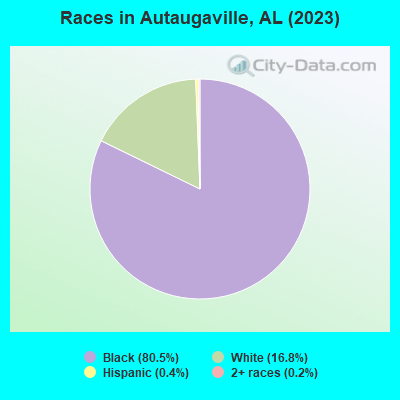
- 81577.2%Black alone
- 21220.1%White alone
- 40.4%Hispanic
- 20.2%Two or more races
According to our research of Alabama and other state lists, there were 8 registered sex offenders living in Autaugaville, Alabama as of April 19, 2024.
The ratio of all residents to sex offenders in Autaugaville is 128 to 1.
Type |
2009 |
2010 |
2011 |
2015 |
2017 |
2019 |
2020 |
2021 |
2022 |
|---|---|---|---|---|---|---|---|---|---|
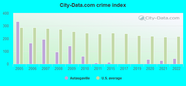
| Murders (per 100,000) | 0 (0.0) | 0 (0.0) | 0 (0.0) | 0 (0.0) | 0 (0.0) | 0 (0.0) | 0 (0.0) | 0 (0.0) | 0 (0.0) |
| Rapes (per 100,000) | 0 (0.0) | 0 (0.0) | 0 (0.0) | 0 (0.0) | 0 (0.0) | 0 (0.0) | 0 (0.0) | 0 (0.0) | 0 (0.0) |
| Robberies (per 100,000) | 0 (0.0) | 0 (0.0) | 0 (0.0) | 0 (0.0) | 0 (0.0) | 0 (0.0) | 0 (0.0) | 0 (0.0) | 0 (0.0) |
| Assaults (per 100,000) | 0 (0.0) | 1 (114.9) | 0 (0.0) | 0 (0.0) | 0 (0.0) | 0 (0.0) | 1 (115.1) | 1 (113.5) | 1 (127.1) |
| Burglaries (per 100,000) | 12 (1,371) | 0 (0.0) | 1 (114.4) | 0 (0.0) | 0 (0.0) | 0 (0.0) | 0 (0.0) | 0 (0.0) | 1 (127.1) |
| Thefts (per 100,000) | 6 (685.7) | 8 (919.5) | 0 (0.0) | 3 (348.4) | 0 (0.0) | 0 (0.0) | 1 (115.1) | 1 (113.5) | 0 (0.0) |
| Auto thefts (per 100,000) | 2 (228.6) | 0 (0.0) | 0 (0.0) | 0 (0.0) | 0 (0.0) | 0 (0.0) | 1 (115.1) | 0 (0.0) | 1 (127.1) |
| Arson (per 100,000) | 0 (0.0) | 0 (0.0) | 0 (0.0) | 0 (0.0) | 0 (0.0) | 0 (0.0) | 0 (0.0) | 0 (0.0) | 0 (0.0) |
| City-Data.com crime index | 141.7 | 59.8 | 8.0 | 13.9 | 0.0 | 0.0 | 36.8 | 27.2 | 44.5 |
The City-Data.com crime index weighs serious crimes and violent crimes more heavily. Higher means more crime, U.S. average is 246.1. It adjusts for the number of visitors and daily workers commuting into cities.
Crime rate in Autaugaville detailed stats: murders, rapes, robberies, assaults, burglaries, thefts, arson
Full-time law enforcement employees in 2021, including police officers: 3 (3 officers - 3 male; 0 female).
| Officers per 1,000 residents here: | 3.41 |
| Alabama average: | 2.40 |
 Recent articles from our blog. Our writers, many of them Ph.D. graduates or candidates, create easy-to-read articles on a wide variety of topics.


 | Move to Montgomery Inevitable... help! (14 replies) |
| Which part of Alabama would I like the most?... (21 replies) |
| Looking into possibilities of moving to Montgomery area (16 replies) |
| Tuskegee, AL information (15 replies) |
| Natural springs somewhere aroung Montgomery (34 replies) |
Latest news from Autaugaville, AL collected exclusively by city-data.com from local newspapers, TV, and radio stations
Ancestries: American (17.8%), German (1.4%), English (1.1%), European (1.1%).
Current Local Time: CST time zone
Elevation: 159 feet
Land area: 7.73 square miles.
Population density: 103 people per square mile (very low).
7 residents are foreign born
| This town: | 0.7% |
| Alabama: | 3.5% |
Median real estate property taxes paid for housing units with mortgages in 2022: $355 (0.2%)
Median real estate property taxes paid for housing units with no mortgage in 2022: $203 (0.3%)
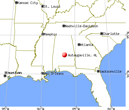
Nearest city with pop. 50,000+: Montgomery, AL  (22.4 miles , pop. 201,568).
Nearest city with pop. 1,000,000+: Houston, TX (548.8 miles , pop. 1,953,631).
Nearest cities:
), ), Latitude: 32.43 N, Longitude: 86.65 W
Area code commonly used in this area: 334
| Here: | 2.2% |
| Alabama: | 2.6% |
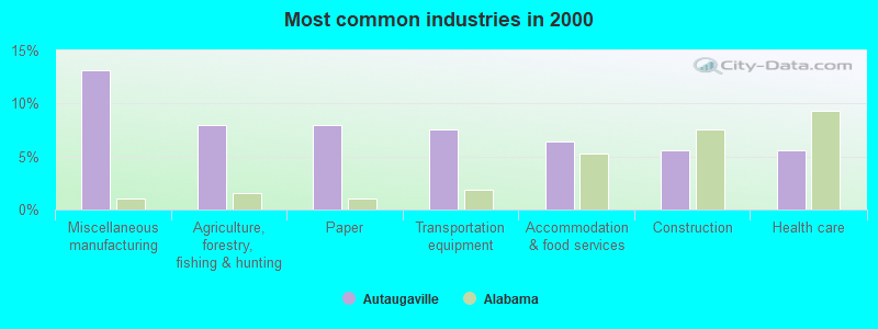
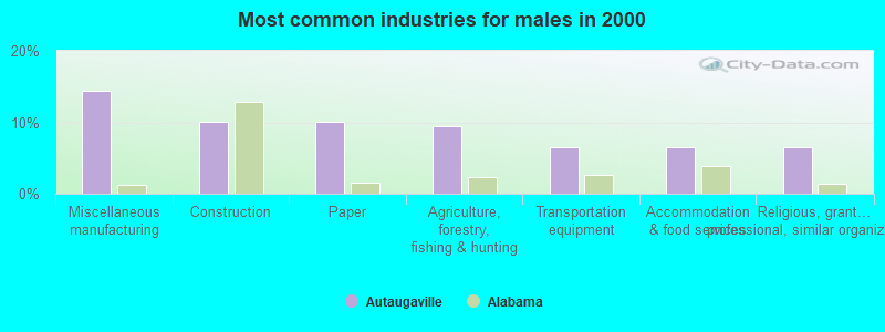
- Miscellaneous manufacturing (13.1%)
- Agriculture, forestry, fishing & hunting (8.0%)
- Paper (8.0%)
- Transportation equipment (7.6%)
- Accommodation & food services (6.4%)
- Construction (5.6%)
- Health care (5.6%)
- Miscellaneous manufacturing (14.5%)
- Construction (10.1%)
- Paper (10.1%)
- Agriculture, forestry, fishing & hunting (9.4%)
- Transportation equipment (6.5%)
- Accommodation & food services (6.5%)
- Religious, grantmaking, civic, professional, similar organizations (6.5%)
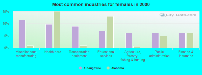
- Miscellaneous manufacturing (11.5%)
- Health care (9.7%)
- Transportation equipment (8.8%)
- Educational services (7.1%)
- Agriculture, forestry, fishing & hunting (6.2%)
- Public administration (6.2%)
- Finance & insurance (6.2%)
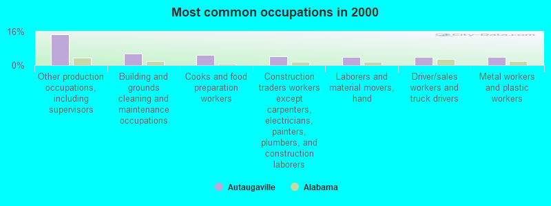
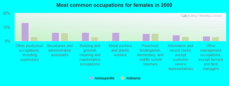
- Other production occupations, including supervisors (14.7%)
- Building and grounds cleaning and maintenance occupations (5.6%)
- Cooks and food preparation workers (4.8%)
- Construction traders workers except carpenters, electricians, painters, plumbers, and construction laborers (4.4%)
- Laborers and material movers, hand (4.0%)
- Driver/sales workers and truck drivers (4.0%)
- Metal workers and plastic workers (4.0%)
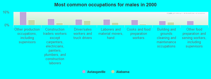
- Other production occupations, including supervisors (15.9%)
- Construction traders workers except carpenters, electricians, painters, plumbers, and construction laborers (8.0%)
- Driver/sales workers and truck drivers (7.2%)
- Laborers and material movers, hand (7.2%)
- Cooks and food preparation workers (6.5%)
- Building and grounds cleaning and maintenance occupations (5.1%)
- Other food preparation and serving workers, including supervisors (5.1%)
- Other production occupations, including supervisors (13.3%)
- Secretaries and administrative assistants (6.2%)
- Building and grounds cleaning and maintenance occupations (6.2%)
- Metal workers and plastic workers (6.2%)
- Preschool, kindergarten, elementary, and middle school teachers (5.3%)
- Information and record clerks, except customer service representatives (4.4%)
- Other management occupations, except farmers and farm managers (3.5%)
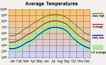
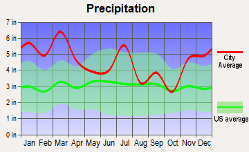
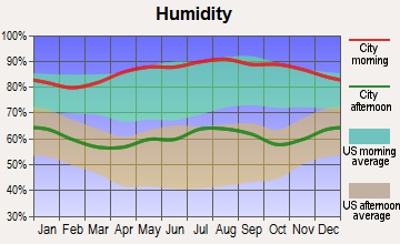
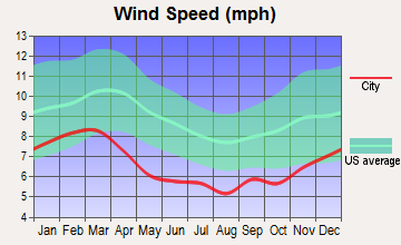
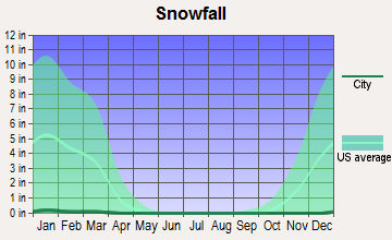
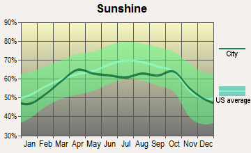
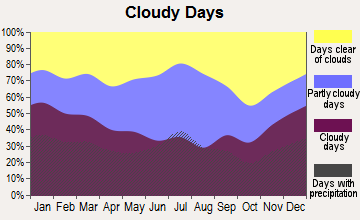
Average climate in Autaugaville, Alabama
Based on data reported by over 4,000 weather stations
(lower is better)
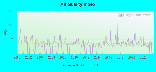
Air Quality Index (AQI) level in 2022 was 65.4. This is about average.
| City: | 65.4 |
| U.S.: | 72.6 |
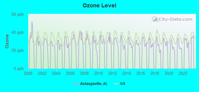
Ozone [ppb] level in 2022 was 29.1. This is about average. Closest monitor was 22.8 miles away from the city center.
| City: | 29.1 |
| U.S.: | 33.3 |
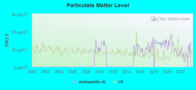
Particulate Matter (PM2.5) [µg/m3] level in 2022 was 6.54. This is better than average. Closest monitor was 21.5 miles away from the city center.
| City: | 6.54 |
| U.S.: | 8.11 |
Tornado activity:
Autaugaville-area historical tornado activity is slightly below Alabama state average. It is 45% greater than the overall U.S. average.
On 3/12/1976, a category F3 (max. wind speeds 158-206 mph) tornado 9.6 miles away from the Autaugaville town center injured 4 people and caused between $500,000 and $5,000,000 in damages.
On 2/17/2008, a category F3 tornado 10.4 miles away from the town center injured 50 people and caused $10 million in damages.
Earthquake activity:
Autaugaville-area historical earthquake activity is significantly above Alabama state average. It is 80% greater than the overall U.S. average.On 1/18/1999 at 07:00:53, a magnitude 4.8 (4.8 MB, 4.0 LG, Depth: 0.6 mi, Class: Light, Intensity: IV - V) earthquake occurred 75.8 miles away from the city center
On 10/24/1997 at 08:35:17, a magnitude 4.9 (4.8 MB, 4.2 MS, 4.9 LG, Depth: 6.2 mi) earthquake occurred 97.6 miles away from Autaugaville center
On 4/29/2003 at 08:59:39, a magnitude 4.9 (4.4 MB, 4.6 MW, 4.9 LG) earthquake occurred 154.4 miles away from the city center
On 6/24/1975 at 11:11:36, a magnitude 4.5 (4.5 MB) earthquake occurred 112.5 miles away from Autaugaville center
On 11/7/2004 at 11:20:21, a magnitude 4.3 (4.3 MW, Depth: 3.1 mi) earthquake occurred 76.1 miles away from the city center
On 4/29/2003 at 08:59:39, a magnitude 4.6 (4.6 MW, Depth: 12.3 mi) earthquake occurred 154.3 miles away from Autaugaville center
Magnitude types: regional Lg-wave magnitude (LG), body-wave magnitude (MB), surface-wave magnitude (MS), moment magnitude (MW)
Natural disasters:
The number of natural disasters in Autauga County (17) is near the US average (15).Major Disasters (Presidential) Declared: 9
Emergencies Declared: 6
Causes of natural disasters: Storms: 7, Floods: 6, Hurricanes: 6, Tornadoes: 6, Winds: 5, Drought: 1, Snowfall: 1, Winter Storm: 1, Other: 1 (Note: some incidents may be assigned to more than one category).
Hospitals and medical centers near Autaugaville:
- AUTAUGA COUNTY HOME CARE (Home Health Center, about 11 miles away; PRATTVILLE, AL)
- PRATTVILLE BAPTIST HOSPITAL Acute Care Hospitals (about 13 miles away; PRATTVILLE, AL)
- PRATTVILLE HEALTH AND REHABILITATION, LLC (Nursing Home, about 14 miles away; PRATTVILLE, AL)
- PCD PRATTVILLE (Dialysis Facility, about 14 miles away; PRATTVILLE, AL)
- SAME DAY SURGERY CENTER (Hospital, about 15 miles away; PRATTVILLE, AL)
Colleges/universities with over 2000 students nearest to Autaugaville:
- Alabama State University (about 22 miles; Montgomery, AL; Full-time enrollment: 5,457)
- Faulkner University (about 26 miles; Montgomery, AL; FT enrollment: 2,887)
- Auburn University at Montgomery (about 29 miles; Montgomery, AL; FT enrollment: 4,092)
- University of Montevallo (about 49 miles; Montevallo, AL; FT enrollment: 2,826)
- Tuskegee University (about 56 miles; Tuskegee, AL; FT enrollment: 2,810)
- Troy University (about 61 miles; Troy, AL; FT enrollment: 16,148)
- Auburn University (about 69 miles; Auburn University, AL; FT enrollment: 22,741)
Public high school in Autaugaville:
- AUTAUGAVILLE SCH (Students: 361, Location: 2708 DUTCH BEND ST, Grades: KG-12)
User-submitted facts and corrections:
- You did not mention religious institutions. There are several churches within the community, in particular Greater St. Joseph A.m.E. Church which will be celebrating their one hundred and twenty year anniversary the fourth Sunday in July 2007. And I belive it is older than the city and is presently pastored by the the Reverend Russell A. Jones.
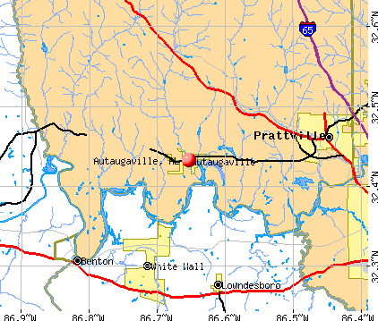
Points of interest:
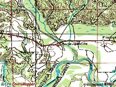
Notable locations in Autaugaville: Autaugaville Volunteer Fire Department (A), Miller State Forest Nursery (B). Display/hide their locations on the map
Cemeteries: Rocky Hill Cemetery (1), Jones Cemetery (2), Saint Joseph Cemetery (3). Display/hide their locations on the map
Reservoir: Crystal Lake (A). Display/hide its location on the map
Creeks: White Water Creek (A), Yellow Water Creek (B). Display/hide their locations on the map
Drinking water stations with addresses in Autaugaville and their reported violations in the past:
AUTAUGAVILLE WATER SYSTEM (Population served: 2,088, Groundwater):Past monitoring violations:
- Follow-up Or Routine LCR Tap M/R - In OCT-11-2011, Contaminant: Lead and Copper Rule. Follow-up actions: St Compliance achieved (SEP-10-2012)
- 4 regular monitoring violations
| This town: | 2.5 people |
| Alabama: | 2.5 people |
| This town: | 69.4% |
| Whole state: | 67.8% |
| This town: | 6.0% |
| Whole state: | 4.7% |
Likely homosexual households (counted as self-reported same-sex unmarried-partner households)
- Lesbian couples: 0.6% of all households
- Gay men: 0.3% of all households
For population 15 years and over in Autaugaville:
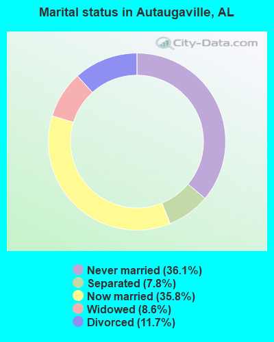
- Never married: 36.1%
- Now married: 35.8%
- Separated: 7.8%
- Widowed: 8.6%
- Divorced: 11.7%
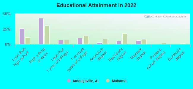
For population 25 years and over in Autaugaville:
- High school or higher: 72.7%
- Bachelor's degree or higher: 10.9%
- Graduate or professional degree: 5.8%
- Unemployed: 10.4%
- Mean travel time to work (commute): 25.9 minutes
| Here: | 9.3 |
| Alabama average: | 11.5 |
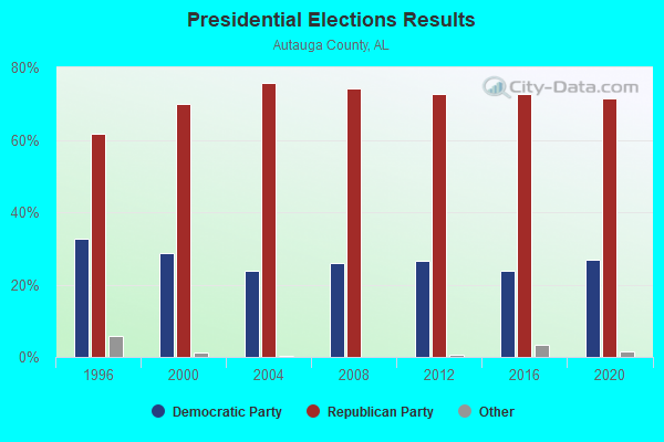
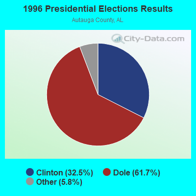
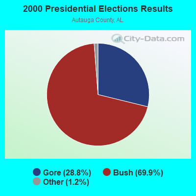
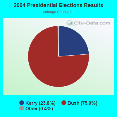
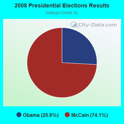

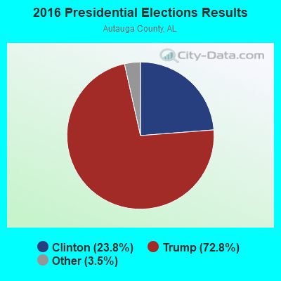

Graphs represent county-level data. Detailed 2008 Election Results
Religion statistics for Autaugaville, AL (based on Autauga County data)
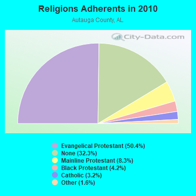
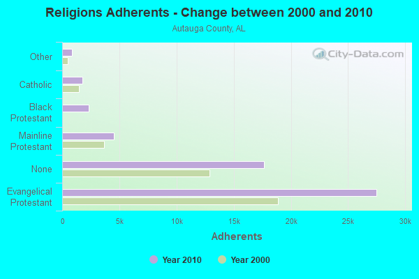
| Religion | Adherents | Congregations |
|---|---|---|
| Evangelical Protestant | 27,503 | 79 |
| Mainline Protestant | 4,522 | 12 |
| Black Protestant | 2,291 | 13 |
| Catholic | 1,766 | 1 |
| Other | 856 | 1 |
| None | 17,633 | - |
Food Environment Statistics:
| Autauga County: | 0.80 / 10,000 pop. |
| Alabama: | 1.89 / 10,000 pop. |
| Here: | 0.20 / 10,000 pop. |
| Alabama: | 0.20 / 10,000 pop. |
| Here: | 0.60 / 10,000 pop. |
| State: | 0.65 / 10,000 pop. |
| Here: | 5.42 / 10,000 pop. |
| Alabama: | 6.32 / 10,000 pop. |
| This county: | 6.82 / 10,000 pop. |
| State: | 5.75 / 10,000 pop. |
| Autauga County: | 11.4% |
| Alabama: | 11.8% |
| Here: | 30.0% |
| Alabama: | 31.7% |
| Autauga County: | 12.4% |
| Alabama: | 13.5% |
Health and Nutrition:
| Here: | 45.9% |
| Alabama: | 49.0% |
| Here: | 40.7% |
| State: | 45.7% |
| This city: | 30.4 |
| Alabama: | 28.9 |
| Autaugaville: | 21.8% |
| Alabama: | 20.7% |
| Autaugaville: | 14.6% |
| State: | 11.0% |
| This city: | 6.7 |
| Alabama: | 6.8 |
| Autaugaville: | 37.3% |
| Alabama: | 34.4% |
| Autaugaville: | 49.5% |
| Alabama: | 55.2% |
| This city: | 81.9% |
| Alabama: | 79.3% |
More about Health and Nutrition of Autaugaville, AL Residents
| Local government employment and payroll (March 2022) | |||||
| Function | Full-time employees | Monthly full-time payroll | Average yearly full-time wage | Part-time employees | Monthly part-time payroll |
|---|---|---|---|---|---|
| Solid Waste Management | 7 | $17,714 | $30,367 | 0 | $0 |
| Other Government Administration | 7 | $35,429 | $60,735 | 0 | $0 |
| Totals for Government | 14 | $53,143 | $45,551 | 0 | $0 |
Autaugaville government finances - Expenditure in 2017 (per resident):
- Current Operations - Central Staff Services: $3,000 ($3.76)
Parks and Recreation: $1,000 ($1.25)
Autaugaville government finances - Revenue in 2017 (per resident):
- Charges - Sewerage: $80,000 ($100.25)
- Revenue - Water Utilities: $245,000 ($307.02)
- Tax - General Sales and Gross Receipts: $155,000 ($194.24)
Occupation and Business License - Other: $59,000 ($73.93)
Property: $14,000 ($17.54)
Alcoholic Beverage Sales: $8,000 ($10.03)
Motor Fuels Sales: $2,000 ($2.51)
10.07% of this county's 2021 resident taxpayers lived in other counties in 2020 ($58,709 average adjusted gross income)
| Here: | 10.07% |
| Alabama average: | 6.87% |
0.14% of residents moved from foreign countries ($1,519 average AGI)
Autauga County: 0.14% Alabama average: 0.02%
Top counties from which taxpayers relocated into this county between 2020 and 2021:
| from Elmore County, AL | |
| from Montgomery County, AL | |
| from Chilton County, AL |
9.27% of this county's 2020 resident taxpayers moved to other counties in 2021 ($59,145 average adjusted gross income)
| Here: | 9.27% |
| Alabama average: | 6.41% |
0.10% of residents moved to foreign countries ($1,081 average AGI)
Autauga County: 0.10% Alabama average: 0.02%
Top counties to which taxpayers relocated from this county between 2020 and 2021:
| to Elmore County, AL | |
| to Montgomery County, AL | |
| to Chilton County, AL |
Strongest AM radio stations in Autaugaville:
- WACV (1170 AM; 10 kW; MONTGOMERY, AL; Owner: MONTGOMERY BROADCAST PROPERTIES, LTD)
- WMSP (740 AM; 10 kW; MONTGOMERY, AL; Owner: CUMULUS LICENSING CORP.)
- WJOX (690 AM; 50 kW; BIRMINGHAM, AL; Owner: CITADEL BROADCASTING COMPANY)
- WDJC (850 AM; 50 kW; BIRMINGHAM, AL; Owner: KIMTRON, INC.)
- WAPI (1070 AM; 50 kW; BIRMINGHAM, AL; Owner: CITADEL BROADCASTING COMPANY)
- WXVI (1600 AM; 5 kW; MONTGOMERY, AL; Owner: SUNSHINE 16 RADIO NETWORK, INC.)
- WLWI (1440 AM; 5 kW; MONTGOMERY, AL; Owner: CUMULUS LICENSING CORP.)
- WAPZ (1250 AM; 5 kW; WETUMPKA, AL; Owner: J & W PROMOTIONS, INC.)
- WNSI (810 AM; 50 kW; JACKSONVILLE, AL; Owner: UNITED BROADCASTING NETWORK, INC.)
- WASG (550 AM; 25 kW; ATMORE, AL; Owner: 550 AM, INC)
- WKNG (1060 AM; daytime; 50 kW; TALLAPOOSA, GA; Owner: WKNG, INC.)
- WGST (640 AM; 50 kW; ATLANTA, GA; Owner: CITICASTERS LICENSES, L.P.)
- WMGY (800 AM; 1 kW; MONTGOMERY, AL; Owner: WMGY RADIO, INC.)
Strongest FM radio stations in Autaugaville:
- WAPR (88.3 FM; SELMA, AL; Owner: UA-ASU-TSU EDUCATIONAL RADIO CORP.)
- WLWI-FM (92.3 FM; MONTGOMERY, AL; Owner: CUMULUS LICENSING CORP.)
- WMXS (103.3 FM; MONTGOMERY, AL; Owner: CUMULUS LICENSING CORP.)
- WQKS-FM (96.1 FM; MONTGOMERY, AL; Owner: MONTGOMERY BROADCAST PROPERTIES, LTD)
- WXFX (95.1 FM; PRATTVILLE, AL; Owner: CUMULUS LICENSING CORP.)
- WBAM-FM (98.9 FM; MONTGOMERY, AL; Owner: DEEP SOUTH BROADCASTING COMPANY)
- WHHY-FM (101.9 FM; MONTGOMERY, AL; Owner: CUMULUS LICENSING CORP.)
- WMCZ (97.1 FM; MILLBROOK, AL; Owner: CAPSTAR TX LIMITED PARTNERSHIP)
- WQLD (104.3 FM; LUVERNE, AL; Owner: CAPSTAR TX LIMITED PARTNERSHIP)
- WZHT (105.7 FM; TROY, AL; Owner: CAPSTAR TX LIMITED PARTNERSHIP)
- WVAS (90.7 FM; MONTGOMERY, AL; Owner: ALABAMA STATE UNIVERSITY (ASU))
- WALX (100.9 FM; SELMA, AL; Owner: ALEXANDER BROADCASTING COMPANY, INC.)
- WLBF (89.1 FM; MONTGOMERY, AL; Owner: FAITH BROADCASTING, INC)
- WDXX (100.1 FM; SELMA, AL; Owner: BROADSOUTH COMMUNICATIONS, INC.)
- WAQU (91.1 FM; SELMA, AL; Owner: AMERICAN FAMILY ASSOCIATION)
- WEZZ-FM (97.7 FM; CLANTON, AL; Owner: SOUTHEASTERN BROADCASTING CO., INC)
TV broadcast stations around Autaugaville:
- WBIH (Channel 29; SELMA, AL; Owner: FLINN BROADCASTING CORPORATION)
- WAKA (Channel 8; SELMA, AL; Owner: ALABAMA BROADCASTING PARTNERS)
- WNCF (Channel 32; MONTGOMERY, AL; Owner: CHANNEL 32 MONTGOMERY LLC)
- W24CK (Channel 24; SELMA, AL; Owner: TRINITY BROADCASTING NETWORK)
- WMCF-TV (Channel 45; MONTGOMERY, AL; Owner: TRINITY BROADCASTING NETWORK)
- WRJM-TV (Channel 67; TROY, AL; Owner: JOSIE PARK BROADCASTING, INC.)
- WSFA (Channel 12; MONTGOMERY, AL; Owner: LIBCO, INC.)
- WETU-LP (Channel 39; WETUMPKA, AL; Owner: CABLE VIDEO PRODUCTIONS, INC.)
- WCOV-TV (Channel 20; MONTGOMERY, AL; Owner: WOODS COMMUNICATIONS CORPORATION)
- WAIQ (Channel 26; MONTGOMERY, AL; Owner: ALABAMA EDUCATIONAL TELEVISION COMMISSION)
- W61DH (Channel 61; MONTGOMERY, AL; Owner: FRAZER MEMORIAL UNITED METHODIST CHURCH)
- Autaugaville, Alabama
- Fatal accident count16
- Vehicles involved in fatal accidents22
- Fatal accidents involving drunk persons:2
- Fatalities17
- Persons involved in fatal accidents36
- Pedestrians involved in fatal accidents2
- Alabama average
- Fatal accident count13851
- Vehicles involved in fatal accidents20640
- Fatal accidents involving drunk persons4228
- Fatalities15499
- Persons involved in fatal accidents34344
- Pedestrians involved in fatal accidents874
- National Bridge Inventory (NBI) Statistics
- 18Number of bridges
- 210ft / 63.8mTotal length
- $32,487,000Total costs
- 212,581Total average daily traffic
- 25,222Total average daily truck traffic
- 268,163Total future (year 2029) average daily traffic
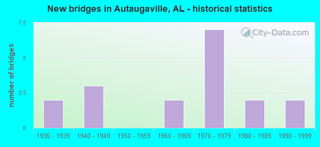
- New bridges - historical statistics
- 21930-1939
- 31940-1949
- 21960-1969
- 71970-1979
- 21980-1989
- 21990-1999
FCC Registered Cell Phone Towers:
1 (See the full list of FCC Registered Cell Phone Towers in Autaugaville)FCC Registered Antenna Towers:
61 (See the full list of FCC Registered Antenna Towers)FCC Registered Broadcast Land Mobile Towers:
5- 2.7 Mi S Of Sr 14 & 3 Mi Wsw (Lat: 32.413750 Lon: -86.700806), Call Sign: KNBJ975, Licensee ID: L00000301,
Assigned Frequencies: 451.150 MHz, 451.150 MHz, 451.225 MHz, 451.225 MHz, Grant Date: 10/24/2001, Expiration Date: 09/16/2011, Cancellation Date: 03/29/2002, Registrant: Alabama Power Company, C/O Scs, 600 North 18th Street / Bin 5n-8485, Birmingham, AL 35203-8485, Phone: (205) 257-3227, Fax: (205) 257-3636, Email:
- Elevated Tank Located On Miller Nursery Road (Lat: 32.429417 Lon: -86.679194), Type: Pipe, Structure height: 7 m, Call Sign: WPSZ570,
Assigned Frequencies: 453.312 MHz, Grant Date: 08/14/2001, Expiration Date: 02/14/2002, Cancellation Date: 05/05/2002, Certifier: Danny B Chavers, Registrant: Duke Instrument Service, 1124 Shelton Beach Road, Saraland, AL 36571, Phone: (251) 675-6067, Fax: (251) 675-5938
- WELL #3, Water Well #3 Located On Miller Nursery Road (Lat: 32.418167 Lon: -86.681194), Type: Pipe, Structure height: 7 m, Call Sign: WPUA239,
Assigned Frequencies: 453.312 MHz, Grant Date: 01/22/2002, Expiration Date: 01/22/2012, Cancellation Date: 03/24/2012, Certifier: Danny B Chavers, Registrant: Duke Instrument Service, 1124 Shelton Beach Road, Saraland, AL 36571, Phone: (251) 675-6067, Fax: (251) 675-5938
- Plant Harris (Lat: 32.381222 Lon: -86.573806), Type: Building, Structure height: 6 m, Call Sign: WPWM605,
Assigned Frequencies: 456.225 MHz, 456.450 MHz, 451.225 MHz, 451.450 MHz, Grant Date: 11/09/2022, Expiration Date: 12/19/2032, Certifier: Billy R Hall Jr., Registrant: Southern Company Services, 600 N. 18th St / Bin 5n-5409, Birmingham, AL 35203, Phone: (205) 257-7600, Fax: (205) 257-2134, Email:
- BASE, 3304 Highway 14 (Lat: 32.451111 Lon: -86.743056), Type: Building, Structure height: 6 m, Call Sign: WQOX206,
Assigned Frequencies: 458.612 MHz, Grant Date: 01/19/2022, Expiration Date: 02/22/2032, Certifier: Melba Chandler, Registrant: Cpi Technologies, Inc., 360 Ryan Rd., Cullman, AL 35057, Phone: (205) 746-7693, Email:
FCC Registered Microwave Towers:
5- STATION, 2.7 Mi S Of Sr 14 3 Mi Wsw Of (Lat: 32.413722 Lon: -86.700806), Overall height: 97.2 m, Call Sign: WNTH532,
Assigned Frequencies: 952.718 MHz, 928.718 MHz, Grant Date: 09/17/2010, Expiration Date: 12/14/2020, Cancellation Date: 10/22/2020, Registrant: Southern Company Services, 600 North 18th St/Bin 5n-8409, Birmingham, AL 35203, Phone: (205) 257-3223, Fax: (202) 872-1331, Email:
- Autaugaville, 2.7 Mi S Of Sr14, 2.9 Mi Wsw (Lat: 32.413750 Lon: -86.701333), Type: Nnltann, Structure height: 91.4 m, Overall height: 98.1 m, Call Sign: WQUC963,
Assigned Frequencies: 6004.50 MHz, Grant Date: 06/06/2014, Expiration Date: 06/06/2024, Certifier: Larry F Butts, Registrant: Southern Company Services, 600 N. 18th St / Bin 5n-5409, Birmingham, AL 35203, Phone: (205) 257-7600, Fax: (205) 257-2134, Email:
- AUTAUGAVILLE, 2.7 Mi S Of Sr14, 2.9 Mi Wsw (Lat: 32.413750 Lon: -86.701333), Type: Gtower, Structure height: 91.4 m, Overall height: 98.1 m, Call Sign: WQXL533,
Assigned Frequencies: 11465.0 MHz, 11505.0 MHz, 11545.0 MHz, 11585.0 MHz, 11465.0 MHz, 11505.0 MHz, 11545.0 MHz, 11585.0 MHz, 11465.0 MHz, 11505.0 MHz... (+22 more), Grant Date: 04/07/2016, Expiration Date: 04/07/2026, Certifier: Larry F Butts, Registrant: Southern Company Services, 600 N. 18th St / Bin 5n-5409, Birmingham, AL 35203, Phone: (205) 257-7600, Fax: (205) 257-2134, Email:
- EVERGREEN, 2433 County Rd 40 W (Lat: 32.547750 Lon: -86.770889), Type: Gtower, Structure height: 46.9 m, Call Sign: WREC341,
Assigned Frequencies: 6004.50 MHz, 6063.80 MHz, 10755.0 MHz, 10835.0 MHz, 10755.0 MHz, 10835.0 MHz, 10755.0 MHz, 10835.0 MHz, 10755.0 MHz, 10835.0 MHz, 10755.0 MHz, 10835.0 MHz, Grant Date: 09/17/2019, Expiration Date: 09/17/2029, Certifier: Gregory M Romano, Registrant: Verizon, 5055 Northpointe Pkwy, Alpharetta, GA 30022, Phone: (770) 797-1070, Email:
- STATION, 2.7 Mi S Of State Rd 14 3 Mi Wsw Of (Lat: 32.413722 Lon: -86.700806), Overall height: 93 m, Call Sign: WAK214,
Assigned Frequencies: 6745.00 MHz, 6765.00 MHz, Grant Date: 08/23/1995, Expiration Date: 08/23/2000, Cancellation Date: 12/03/2000, Phone: (205) 250-2561
FCC Registered Amateur Radio Licenses:
1- Call Sign: W4FHH, Grant Date: 08/11/1992, Expiration Date: 08/11/2002, Cancellation Date: 08/12/2004, Registrant: Warren K De Bardelaben, 330 Cr 17, Autaugaville, AL 36003
FAA Registered Aircraft:
2- Aircraft: CESSNA 172L (Category: Land, Seats: 4, Weight: Up to 12,499 Pounds, Speed: 105 mph), Engine: LYCOMING 0-320 SERIES (180 HP) (Reciprocating)
N-Number: 389CL, N389CL, N-389CL, Serial Number: 17260700, Year manufactured: 1972, Airworthiness Date: 06/01/1972, Certificate Issue Date: 04/03/2001
Registrant (Corporation): Canaan Land Church Inc, Po Box 310, Autaugaville, AL 36003 - Aircraft: CESSNA 150G (Category: Land, Seats: 2, Weight: Up to 12,499 Pounds, Speed: 90 mph), Engine: CONT MOTOR 0-200 SERIES (100 HP) (4 Cycle)
N-Number: 4JR, N4JR, N-4JR, Serial Number: 15064844, Year manufactured: 1966, Airworthiness Date: 03/09/1987, Certificate Issue Date: 03/05/2019
Registrant (Individual): Jared M Templet, 601 N Pickett St, Autaugaville, AL 36003
| Home Mortgage Disclosure Act Aggregated Statistics For Year 2009 (Based on 1 partial tract) | ||
| C) Refinancings | ||
|---|---|---|
| Number | Average Value | |
| LOANS ORIGINATED | 1 | $187,950 |
| APPLICATIONS APPROVED, NOT ACCEPTED | 0 | $0 |
| APPLICATIONS DENIED | 1 | $74,920 |
| APPLICATIONS WITHDRAWN | 1 | $85,900 |
| FILES CLOSED FOR INCOMPLETENESS | 0 | $0 |
Detailed HMDA statistics for the following Tracts: 0211.00
| Most common first names in Autaugaville, AL among deceased individuals | ||
| Name | Count | Lived (average) |
|---|---|---|
| James | 18 | 71.6 years |
| Mary | 17 | 75.6 years |
| William | 16 | 76.9 years |
| Robert | 14 | 65.0 years |
| Willie | 14 | 69.8 years |
| Henry | 12 | 69.5 years |
| Charlie | 10 | 68.4 years |
| Jessie | 8 | 71.0 years |
| Edward | 7 | 65.0 years |
| Walter | 6 | 65.7 years |
| Most common last names in Autaugaville, AL among deceased individuals | ||
| Last name | Count | Lived (average) |
|---|---|---|
| Jones | 26 | 74.7 years |
| Howard | 25 | 70.9 years |
| Motley | 23 | 74.4 years |
| Steele | 20 | 68.0 years |
| Houser | 18 | 73.2 years |
| Palmer | 14 | 67.3 years |
| Davis | 12 | 79.0 years |
| Golson | 12 | 77.8 years |
| Tyus | 11 | 64.4 years |
| Taylor | 10 | 73.0 years |
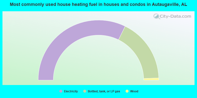
- 64.6%Electricity
- 34.3%Bottled, tank, or LP gas
- 1.1%Wood
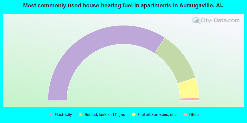
- 69.3%Electricity
- 22.0%Bottled, tank, or LP gas
- 8.7%Fuel oil, kerosene, etc.
Autaugaville compared to Alabama state average:
- Median house value below state average.
- Black race population percentage significantly above state average.
- Hispanic race population percentage significantly below state average.
- Median age below state average.
- Foreign-born population percentage significantly below state average.
- Length of stay since moving in significantly above state average.
- Percentage of population with a bachelor's degree or higher below state average.
Autaugaville on our top lists:
- #1 on the list of "Top 101 cities with the highest percentage of English-only speaking households, population 500+"
- #94 on the list of "Top 101 counties with the highest percentage of residents relocating from foreign countries between 2010 and 2011"

|
Total of 1 patent application in 2008-2024.