Axson, Georgia
Submit your own pictures of this place and show them to the world
- OSM Map
- General Map
- Google Map
- MSN Map

| Males: 667 | |
| Females: 658 |
| Median resident age: | 32.3 years |
| Georgia median age: | 33.4 years |
Zip code: 31624
| Axson: | $37,558 |
| GA: | $72,837 |
Estimated per capita income in 2022: $20,605 (it was $10,725 in 2000)
Axson CCD income, earnings, and wages data
Estimated median house or condo value in 2022: $89,804 (it was $31,300 in 2000)
| Axson: | $89,804 |
| GA: | $297,400 |
Detailed information about poverty and poor residents in Axson, GA


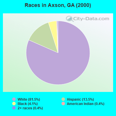
- 1,00781.5%White alone
- 16713.5%Hispanic
- 514.1%Black alone
- 50.4%American Indian alone
- 50.4%Two or more races
Races in Axson detailed stats: ancestries, foreign born residents, place of birth
According to our research of Georgia and other state lists, there were 2 registered sex offenders living in Axson, Georgia as of April 19, 2024.
The ratio of all residents to sex offenders in Axson is 663 to 1.
The ratio of registered sex offenders to all residents in this city is lower than the state average.
 Recent articles from our blog. Our writers, many of them Ph.D. graduates or candidates, create easy-to-read articles on a wide variety of topics.

Current Local Time: EST time zone
Elevation: 177 feet
Land area: 88.8 square miles.
Population density: 15 people per square mile (very low).

| Axson CCD: | 1.1% ($349) |
| Georgia: | 0.9% ($919) |
Nearest city with pop. 50,000+: Albany, GA  (88.5 miles , pop. 76,939).
Nearest city with pop. 200,000+: Jacksonville, FL (91.1 miles , pop. 735,617).
Nearest city with pop. 1,000,000+: Philadelphia, PA (737.1 miles , pop. 1,517,550).
Nearest cities:
), ), ), )Latitude: 31.28 N, Longitude: 82.71 W
Area code commonly used in this area: 912

| Here: | 2.4% |
| Georgia: | 2.9% |
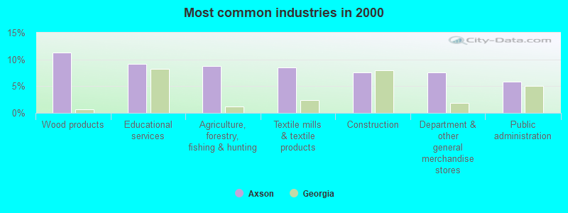
- Wood products (11.3%)
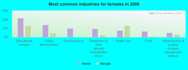
- Educational services (9.2%)
- Agriculture, forestry, fishing & hunting (8.7%)
- Textile mills & textile products (8.5%)
- Construction (7.5%)
- Department & other general merchandise stores (7.5%)
- Public administration (5.9%)
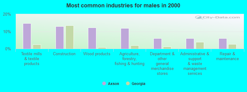
- Textile mills & textile products (14.6%)
- Construction (13.0%)
- Wood products (12.2%)
- Agriculture, forestry, fishing & hunting (11.8%)
- Department & other general merchandise stores (6.1%)
- Administrative & support & waste management services (6.1%)
- Repair & maintenance (6.1%)
- Educational services (21.8%)
- Public administration (14.0%)
- Wood products (10.1%)
- Department & other general merchandise stores (9.5%)
- Health care (7.8%)
- Food (6.7%)
- Administrative & support & waste management services (5.0%)
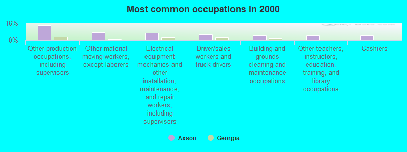
- Other production occupations, including supervisors (13.9%)
- Other material moving workers, except laborers (7.3%)
- Electrical equipment mechanics and other installation, maintenance, and repair workers, including supervisors (6.6%)
- Driver/sales workers and truck drivers (5.2%)
- Building and grounds cleaning and maintenance occupations (4.5%)
- Other teachers, instructors, education, training, and library occupations (4.5%)
- Cashiers (4.2%)
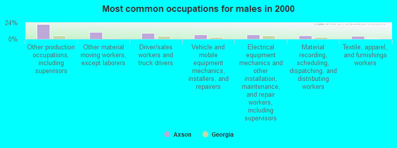
- Other production occupations, including supervisors (22.0%)
- Other material moving workers, except laborers (10.2%)
- Driver/sales workers and truck drivers (8.9%)
- Vehicle and mobile equipment mechanics, installers, and repairers (6.5%)
- Electrical equipment mechanics and other installation, maintenance, and repair workers, including supervisors (6.5%)
- Material recording, scheduling, dispatching, and distributing workers (4.9%)
- Textile, apparel, and furnishings workers (4.5%)
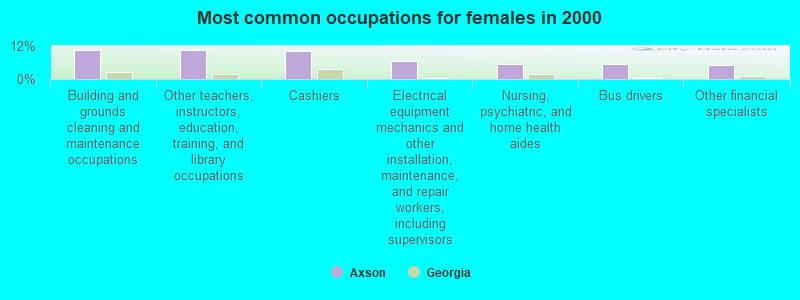
- Building and grounds cleaning and maintenance occupations (10.6%)
- Other teachers, instructors, education, training, and library occupations (10.6%)
- Cashiers (10.1%)
- Electrical equipment mechanics and other installation, maintenance, and repair workers, including supervisors (6.7%)
- Nursing, psychiatric, and home health aides (5.6%)
- Bus drivers (5.6%)
- Other financial specialists (5.0%)
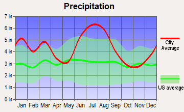
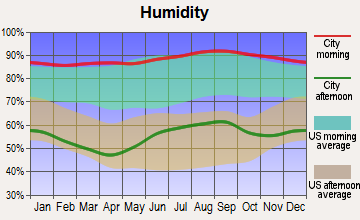
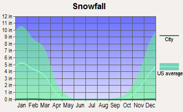
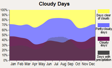
Average climate in Axson, Georgia
Based on data reported by over 4,000 weather stations


(lower is better)
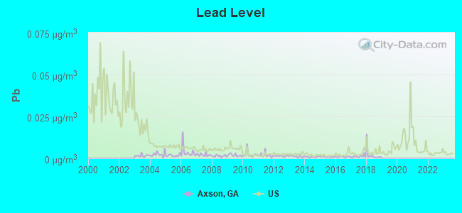
Lead (Pb) [µg/m3] level in 2018 was 0.00200. This is significantly better than average. Closest monitor was 16.3 miles away from the city center.
| City: | 0.00200 |
| U.S.: | 0.00931 |
Tornado activity:
Axson-area historical tornado activity is slightly below Georgia state average. It is 5% smaller than the overall U.S. average.
On 11/18/1968, a category F3 (max. wind speeds 158-206 mph) tornado 25.3 miles away from the Axson place center caused between $5000 and $50,000 in damages.
On 5/11/1952, a category F3 tornado 30.2 miles away from the place center injured 10 people and caused between $500,000 and $5,000,000 in damages.
Earthquake activity:
Axson-area historical earthquake activity is significantly above Georgia state average. It is 40% smaller than the overall U.S. average.On 8/2/1974 at 08:52:09, a magnitude 4.9 (4.3 MB, 4.9 LG, Class: Light, Intensity: IV - V) earthquake occurred 179.7 miles away from Axson center
On 11/22/1974 at 05:25:55, a magnitude 4.7 (4.7 MB) earthquake occurred 187.3 miles away from Axson center
On 10/24/1997 at 08:35:17, a magnitude 4.9 (4.8 MB, 4.2 MS, 4.9 LG, Depth: 6.2 mi) earthquake occurred 270.2 miles away from the city center
On 4/29/2003 at 08:59:39, a magnitude 4.9 (4.4 MB, 4.6 MW, 4.9 LG) earthquake occurred 279.6 miles away from Axson center
On 8/21/1992 at 16:31:55, a magnitude 4.4 (4.1 MB, 4.1 LG, 4.4 LG, Depth: 6.2 mi) earthquake occurred 194.9 miles away from the city center
On 1/18/1999 at 07:00:53, a magnitude 4.8 (4.8 MB, 4.0 LG, Depth: 0.6 mi) earthquake occurred 303.6 miles away from the city center
Magnitude types: regional Lg-wave magnitude (LG), body-wave magnitude (MB), surface-wave magnitude (MS), moment magnitude (MW)
Natural disasters:
The number of natural disasters in Atkinson County (10) is smaller than the US average (15).Major Disasters (Presidential) Declared: 5
Emergencies Declared: 3
Causes of natural disasters: Floods: 3, Hurricanes: 3, Storms: 3, Tornadoes: 2, Drought: 1, Fire: 1, Tropical Storm: 1, Wind: 1, Other: 1 (Note: some incidents may be assigned to more than one category).
Colleges/universities with over 2000 students nearest to Axson:
- South Georgia State College (about 18 miles; Douglas, GA; Full-time enrollment: 2,507)
- Valdosta State University (about 46 miles; Valdosta, GA; FT enrollment: 11,155)
- Wiregrass Georgia Technical College (about 47 miles; Valdosta, GA; FT enrollment: 3,246)
- Abraham Baldwin Agricultural College (about 51 miles; Tifton, GA; FT enrollment: 2,564)
- College of Coastal Georgia (about 73 miles; Brunswick, GA; FT enrollment: 2,447)
- Florida Gateway College (about 77 miles; Lake City, FL; FT enrollment: 2,179)
- Albany State University (about 88 miles; Albany, GA; FT enrollment: 3,662)
Points of interest:
Notable location: Axson Volunteer Fire Department (A). Display/hide its location on the map
Churches in Axson include: Allen Chapel (A), First Born Church (B), Mount Zion Church (C), Red Bluff Church (D), Stokesville Church (E), Utah Church (F), Axson Church (G). Display/hide their locations on the map
Cemeteries: Utah Cemetery (1), White Cemetery (2), Kight Cemetery (3). Display/hide their locations on the map
Swamps: Head of the Creek (A). Display/hide its location on the map
Streams, rivers, and creeks: Sweetwater Creek (A), Smut Branch (B), Pudding Creek (C), Big Branch (D), Little Red Bluff Creek (E). Display/hide their locations on the map
| This place: | 2.8 people |
| Georgia: | 2.6 people |
| This place: | 74.4% |
| Whole state: | 68.5% |
| This place: | 7.8% |
| Whole state: | 5.9% |
Likely homosexual households (counted as self-reported same-sex unmarried-partner households)
- Lesbian couples: 0.2% of all households
- Gay men: 0.4% of all households
| This place: | 23.8% |
| Whole state: | 13.0% |
| This place: | 6.2% |
| Whole state: | 6.1% |
For population 15 years and over in Axson:
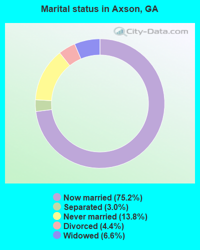
- Never married: 13.8%
- Now married: 75.2%
- Separated: 3.0%
- Widowed: 6.6%
- Divorced: 4.4%
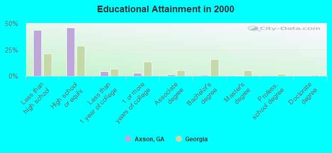
For population 25 years and over in Axson:
- High school or higher: 56.1%
- Bachelor's degree or higher: 1.6%
- Graduate or professional degree: 0.7%
- Unemployed: 7.8%
- Mean travel time to work (commute): 26.0 minutes
| Here: | 14.6 |
| Georgia average: | 13.3 |
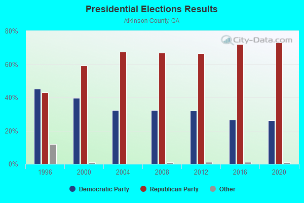
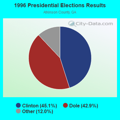
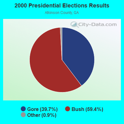
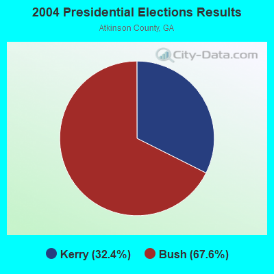
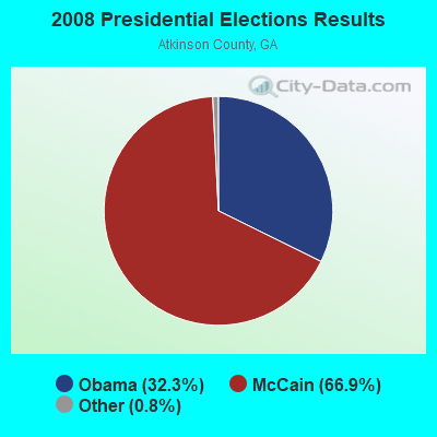

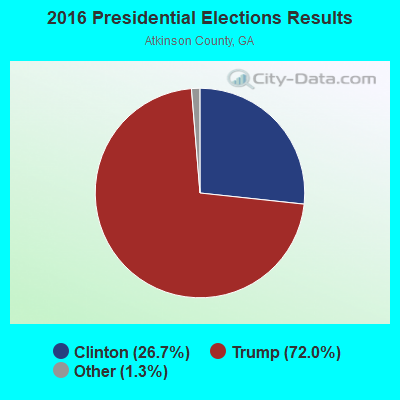

Graphs represent county-level data. Detailed 2008 Election Results
Religion statistics for Axson, GA (based on Atkinson County data)
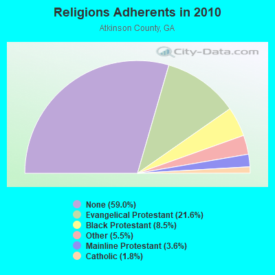
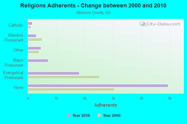
| Religion | Adherents | Congregations |
|---|---|---|
| Evangelical Protestant | 1,810 | 13 |
| Black Protestant | 712 | 4 |
| Other | 464 | 1 |
| Mainline Protestant | 298 | 5 |
| Catholic | 152 | 1 |
| None | 4,939 | - |
Food Environment Statistics:
| Atkinson County: | 6.13 / 10,000 pop. |
| Georgia: | 1.91 / 10,000 pop. |
| Atkinson County: | 7.36 / 10,000 pop. |
| Georgia: | 5.12 / 10,000 pop. |
| This county: | 4.90 / 10,000 pop. |
| State: | 7.41 / 10,000 pop. |
| Here: | 10.3% |
| Georgia: | 10.4% |
| This county: | 28.5% |
| Georgia: | 27.8% |
| Atkinson County: | 20.5% |
| Georgia: | 14.6% |
Strongest AM radio stations in Axson:
- WDMG (860 AM; 5 kW; DOUGLAS, GA; Owner: RTG RADIO, LLC)
- WFVR (910 AM; 50 kW; VALDOSTA, GA; Owner: RAMA COMMUNICATIONS, INC.)
- WOKV (690 AM; 50 kW; JACKSONVILLE, FL; Owner: COX RADIO, INC.)
- WOKA (1310 AM; 4 kW; DOUGLAS, GA; Owner: COFFEE COUNTY BROADCASTERS, INC.)
- WOBS (1530 AM; daytime; 50 kW; JACKSONVILLE, FL; Owner: WORD BROADCASTING NETWORK, INC.)
- WSTT (730 AM; 25 kW; THOMASVILLE, GA; Owner: MARION R. WILLIAMS)
- WGSR (1570 AM; 50 kW; FERNANDINA BEACH, FL; Owner: RJM COMMUNICATIONS, INC)
- WMAC (940 AM; 50 kW; MACON, GA; Owner: CUMULUS LICENSING CORP.)
- WCGA (1100 AM; daytime; 10 kW; WOODBINE, GA; Owner: COX BROADCAST GROUP, INC.)
- WUFE (1260 AM; daytime; 5 kW; BAXLEY, GA; Owner: SOUTH GEORGIA BROADCASTERS, INC.)
- WFNS (1350 AM; 2 kW; BLACKSHEAR, GA; Owner: MARMAC COMMUNICATIONS, LLC)
- WJEM (1150 AM; 5 kW; VALDOSTA, GA; Owner: WJEM, INC.)
- WMGA (1130 AM; 10 kW; MOULTRIE, GA; Owner: RADIO MOULTRIE, INC.)
Strongest FM radio stations in Axson:
- WXVS (90.1 FM; WAYCROSS, GA; Owner: GEORGIA PUBLIC TELECOMMUNICATIONS COMMISSION)
- WPNG (101.9 FM; PEARSON, GA; Owner: KM RADIO OF PEARSON, L.L.C.)
- WOKA-FM (106.7 FM; DOUGLAS, GA; Owner: COFFEE COUNTY BROADCASTERS, INC.)
- WWSN (103.3 FM; WAYCROSS, GA; Owner: QANTUM OF BRUNSWICK LICENSE COMPANY, LLC)
- WBYZ (94.5 FM; BAXLEY, GA; Owner: SOUTH GEORGIA BROADCASTERS, INC.)
- WDMG-FM (99.5 FM; DOUGLAS, GA; Owner: RTG RADIO, LLC)
- WAJQ-FM (104.3 FM; ALMA, GA; Owner: BLUEBERRY BROADCASTING COMPANY, INC.)
- WJYF (95.3 FM; NASHVILLE, GA; Owner: TIFTON BROADCASTING CORP.)
- WBTY (98.7 FM; HOMERVILLE, GA; Owner: SOUTHERN BROADCASTING & INVESTMENT CO., INC.)
- WKUB (105.1 FM; BLACKSHEAR, GA; Owner: MATTOX BROADCASTING, INC.)
TV broadcast stations around Axson:
- WXGA-TV (Channel 8; WAYCROSS, GA; Owner: GEORGIA PUBLIC TELECOMMUNICATIONS COMMISSION)
- WPXC-TV (Channel 21; BRUNSWICK, GA; Owner: PAXSON JAX LICENSE, INC.)
- WVAG (Channel 44; VALDOSTA, GA; Owner: HUTCHENS COMMUNICATIONS, INC.)
Axson fatal accident list:
FCC Registered Antenna Towers:
13 (See the full list of FCC Registered Antenna Towers in Axson)FCC Registered Broadcast Land Mobile Towers:
2- Lat: 31.352778 Lon: -82.760833, Call Sign: WQUA484,
Assigned Frequencies: 159.645 MHz, Grant Date: 05/20/2014, Expiration Date: 05/20/2024, Certifier: Phillip Murry, Registrant: Washington Radio Reports, Gettsburg, PA 17325, Phone: (717) 334-0668, Fax: (717) 334-6440, Email:
- Lat: 31.324889 Lon: -82.784028, Call Sign: WQYA617,
Assigned Frequencies: 160.020 MHz, Grant Date: 08/01/2016, Expiration Date: 08/01/2026, Certifier: Tom Morris, Registrant: Washington Radio Reports, Gettysburg, PA 17325, Phone: (717) 334-0668, Fax: (717) 334-6440, Email:
FCC Registered Microwave Towers:
1- AXSON, Hwy 82 (Hv661 - Axson) (Lat: 31.281917 Lon: -82.758778), Type: Ltower, Structure height: 97 m, Overall height: 98 m, Call Sign: WQQG451,
Assigned Frequencies: 11365.0 MHz, Grant Date: 12/04/2012, Expiration Date: 12/04/2022, Cancellation Date: 02/04/2023, Certifier: Chris Harris, Registrant: Conterra Ultra Broadband, LLC, 2101 Rexford Rd, Ste 200e, Charlotte, NC 28211, Phone: (704) 936-1801, Fax: (704) 936-1801, Email:
FCC Registered Amateur Radio Licenses:
3- Call Sign: KE4AFL, Licensee ID: L00670700, Grant Date: 04/09/2013, Expiration Date: 04/20/2023, Registrant: Kathryn G Abbey, 26 Doc Sutton Rd., Axson, GA 31624
- Call Sign: KR4WH, Previous Call Sign: KD4YST, Grant Date: 07/15/1994, Expiration Date: 05/31/2004, Cancellation Date: 06/01/2006, Registrant: Zdzislaw Hokaszewski, Rt 1 Box 48, Axson, GA 31624
- Call Sign: WA4WVE, Licensee ID: L01020668, Grant Date: 05/23/2005, Expiration Date: 08/17/2015, Cancellation Date: 08/18/2017, Certifier: Carl B Christopher, Registrant: Carl B Christopher, Rt 1 Box 129, Axson, GA 31624
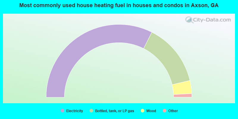
- 64.9%Electricity
- 27.7%Bottled, tank, or LP gas
- 5.8%Wood
- 1.0%Fuel oil, kerosene, etc.
- 0.5%No fuel used
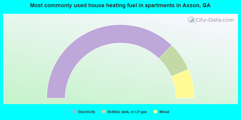
- 74.5%Electricity
- 12.8%Bottled, tank, or LP gas
- 12.8%Wood
Axson compared to Georgia state average:
- Median household income below state average.
- Median house value significantly below state average.
- Unemployed percentage below state average.
- Black race population percentage significantly below state average.
- Median age below state average.
- Foreign-born population percentage significantly below state average.
- Renting percentage below state average.
- Length of stay since moving in significantly above state average.
- Number of rooms per house significantly below state average.
- House age significantly below state average.
- Number of college students significantly below state average.
- Percentage of population with a bachelor's degree or higher significantly below state average.