Banks-Josie, Alabama
Submit your own pictures of this place and show them to the world
- OSM Map
- Google Map
- MSN Map
| Males: 1,074 | |
| Females: 1,123 |
| Median resident age: | 37.2 years |
| Alabama median age: | 35.8 years |
Zip code: 36005
| Banks-Josie: | $52,981 |
| AL: | $59,674 |
Estimated per capita income in 2022: $32,389 (it was $17,858 in 2000)
Banks-Josie CCD income, earnings, and wages data
Estimated median house or condo value in 2022: $145,969 (it was $52,500 in 2000)
| Banks-Josie: | $145,969 |
| AL: | $200,900 |
Detailed information about poverty and poor residents in Banks-Josie, AL
Compare current foreclosures near your location:
| Photo | Address | Area | Beds / Baths | Price | Details |
|---|---|---|---|---|---|

|
#1
N Rhodes St
Pretty Prairie, KS 67570
|
1,725 sq. feet
|
2 baths 4 beds |
show details | |

|
#2
S Goddard Rd
Goddard, KS 67052
|
1,054 sq. feet
|
2 baths 2 beds |
show details | |

|
#3
W 21st St N
Cheney, KS 67025
|
3,190 sq. feet
|
3 baths 5 beds |
show details | |

|
#4
E Winterset St
Goddard, KS 67052
|
816 sq. feet
|
1 baths 2 beds |
show details | |

|
#5
NE Waterloo Ave
Murdock, KS 67111
|
1,220 sq. feet
|
1 baths 3 beds |
show details | |

|
#6
W 39th St S
Goddard, KS 67052
|
4,221 sq. feet
|
3 baths 3 beds |
show details | |

|
#7
E Arlington Rd
Haven, KS 67543
|
960 sq. feet
|
1 baths 2 beds |
show details | |

|
#8
S 391st St W
Cheney, KS 67025
|
2,558 sq. feet
|
3 baths 3 beds |
show details | |

|
#9
SE Viney Ave
Murdock, KS 67111
|
- sq. feet
|
- baths - beds |
show details | |

|
#10
W Main St
Mount Hope, KS 67108
|
- sq. feet
|
- baths - beds |
show details |
| Photo | Address | Area | Beds / Baths | Price | Details |
|---|---|---|---|---|---|

|
#11
N 189th Cir W
Colwich, KS 67030
|
- sq. feet
|
- baths - beds |
show details | |

|
#12
N Main St
Goddard, KS 67052
|
- sq. feet
|
- baths - beds |
show details | |

|
#13
Martens Ct
Goddard, KS 67052
|
- sq. feet
|
- baths - beds |
show details | |

|
#14
E 4th Ave Apt 1
Cheney, KS 67025
|
- sq. feet
|
- baths - beds |
show details | |

|
#15
W Maple St Lot D
Goddard, KS 67052
|
- sq. feet
|
- baths - beds |
show details | |

|
#16
W 47th St S
Garden Plain, KS 67050
|
- sq. feet
|
- baths - beds |
show details | |

|
#17
S 339th St W
Cheney, KS 67025
|
- sq. feet
|
- baths - beds |
show details | |

|
#18
E Casey Dr
Goddard, KS 67052
|
- sq. feet
|
- baths - beds |
show details | |

|
Check over 1 million property listings on Foreclosure.com!
|
browse all offers | |||

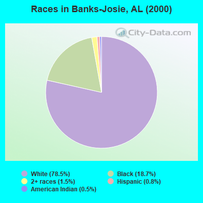
- 1,70078.5%White alone
- 40518.7%Black alone
- 321.5%Two or more races
- 170.8%Hispanic
- 100.5%American Indian alone
- 10.05%Other race alone
 Recent articles from our blog. Our writers, many of them Ph.D. graduates or candidates, create easy-to-read articles on a wide variety of topics.

Current Local Time: CST time zone
Land area: 136.0 square miles.
Population density: 16 people per square mile (very low).
| Banks-Josie CCD: | 0.4% ($199) |
| Alabama: | 0.4% ($289) |
Nearest city with pop. 50,000+: Montgomery, AL  (45.5 miles , pop. 201,568).
Nearest city with pop. 1,000,000+: Houston, TX (587.4 miles , pop. 1,953,631).
Nearest cities:
), ), ), ), ), )Latitude: 31.85 N, Longitude: 85.79 W
Area code commonly used in this area: 334
| Here: | 3.2% |
| Alabama: | 2.6% |
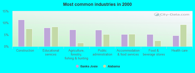
- Construction (11.3%)
- Educational services (8.0%)
- Agriculture, forestry, fishing & hunting (7.1%)
- Public administration (7.0%)
- Accommodation & food services (5.2%)
- Food & beverage stores (5.2%)
- Health care (4.7%)
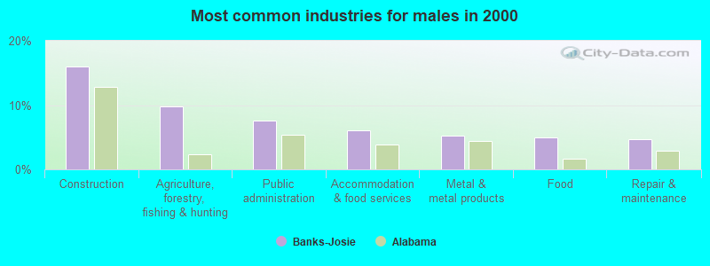
- Construction (16.0%)
- Agriculture, forestry, fishing & hunting (9.7%)
- Public administration (7.5%)
- Accommodation & food services (6.1%)
- Metal & metal products (5.2%)
- Food (5.0%)
- Repair & maintenance (4.7%)
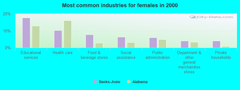
- Educational services (17.7%)
- Health care (10.3%)
- Food & beverage stores (7.7%)
- Social assistance (6.3%)
- Public administration (6.0%)
- Department & other general merchandise stores (4.0%)
- Private households (4.0%)
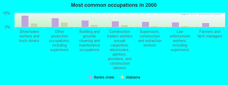
- Driver/sales workers and truck drivers (8.3%)
- Other production occupations, including supervisors (6.5%)
- Building and grounds cleaning and maintenance occupations (5.0%)
- Construction traders workers except carpenters, electricians, painters, plumbers, and construction laborers (4.4%)
- Supervisors, construction and extraction workers (3.9%)
- Law enforcement workers, including supervisors (3.4%)
- Farmers and farm managers (3.0%)
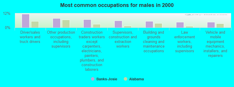
- Driver/sales workers and truck drivers (11.5%)
- Other production occupations, including supervisors (7.8%)
- Construction traders workers except carpenters, electricians, painters, plumbers, and construction laborers (6.8%)
- Supervisors, construction and extraction workers (6.0%)
- Building and grounds cleaning and maintenance occupations (5.5%)
- Law enforcement workers, including supervisors (4.6%)
- Vehicle and mobile equipment mechanics, installers, and repairers (4.6%)
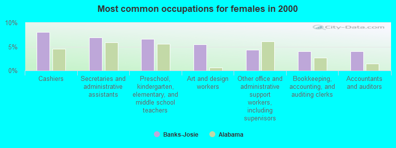
- Cashiers (8.0%)
- Secretaries and administrative assistants (6.9%)
- Preschool, kindergarten, elementary, and middle school teachers (6.6%)
- Art and design workers (5.4%)
- Other office and administrative support workers, including supervisors (4.3%)
- Bookkeeping, accounting, and auditing clerks (4.0%)
- Accountants and auditors (4.0%)
Average climate in Banks-Josie, Alabama
Based on data reported by over 4,000 weather stations


(lower is better)
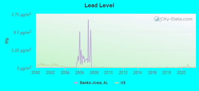
Lead (Pb) [µg/m3] level in 2007 was 0.230. This is significantly worse than average. Closest monitor was 11.6 miles away from the city center.
| City: | 0.230 |
| U.S.: | 0.009 |
Tornado activity:
Banks-Josie-area historical tornado activity is slightly below Alabama state average. It is 43% greater than the overall U.S. average.
On 4/18/1969, a category F4 (max. wind speeds 207-260 mph) tornado 26.2 miles away from the Banks-Josie place center killed 2 people and injured 14 people and caused between $50,000 and $500,000 in damages.
On 12/19/1974, a category F3 (max. wind speeds 158-206 mph) tornado 2.9 miles away from the place center caused between $50,000 and $500,000 in damages.
Earthquake activity:
Banks-Josie-area historical earthquake activity is significantly above Alabama state average. It is 35% greater than the overall U.S. average.On 10/24/1997 at 08:35:17, a magnitude 4.9 (4.8 MB, 4.2 MS, 4.9 LG, Depth: 6.2 mi, Class: Light, Intensity: IV - V) earthquake occurred 100.5 miles away from the city center
On 1/18/1999 at 07:00:53, a magnitude 4.8 (4.8 MB, 4.0 LG, Depth: 0.6 mi) earthquake occurred 137.2 miles away from Banks-Josie center
On 4/29/2003 at 08:59:39, a magnitude 4.9 (4.4 MB, 4.6 MW, 4.9 LG) earthquake occurred 183.3 miles away from Banks-Josie center
On 8/2/1974 at 08:52:09, a magnitude 4.9 (4.3 MB, 4.9 LG) earthquake occurred 237.7 miles away from the city center
On 4/29/2003 at 08:59:39, a magnitude 4.6 (4.6 MW, Depth: 12.3 mi) earthquake occurred 183.3 miles away from the city center
On 6/24/1975 at 11:11:36, a magnitude 4.5 (4.5 MB) earthquake occurred 175.8 miles away from the city center
Magnitude types: regional Lg-wave magnitude (LG), body-wave magnitude (MB), surface-wave magnitude (MS), moment magnitude (MW)
Natural disasters:
The number of natural disasters in Pike County (16) is near the US average (15).Major Disasters (Presidential) Declared: 9
Emergencies Declared: 5
Causes of natural disasters: Storms: 7, Hurricanes: 6, Floods: 5, Tornadoes: 5, Winds: 3, Drought: 1, Snowfall: 1, Winter Storm: 1, Other: 1 (Note: some incidents may be assigned to more than one category).
Hospitals and medical centers near Banks-Josie:
Colleges/universities with over 2000 students nearest to Banks-Josie:
- Troy University (about 10 miles; Troy, AL; Full-time enrollment: 16,148)
- Enterprise State Community College (about 39 miles; Enterprise, AL; FT enrollment: 2,101)
- Tuskegee University (about 41 miles; Tuskegee, AL; FT enrollment: 2,810)
- George C Wallace State Community College-Dothan (about 42 miles; Dothan, AL; FT enrollment: 3,611)
- Auburn University at Montgomery (about 43 miles; Montgomery, AL; FT enrollment: 4,092)
- Faulkner University (about 45 miles; Montgomery, AL; FT enrollment: 2,887)
- Alabama State University (about 47 miles; Montgomery, AL; FT enrollment: 5,457)
Points of interest:
Notable locations in Banks-Josie: Jerusalem Campground (A), Devil Neck (B), Saco Volunteer Fire Department (C), Banks Volunteer Fire Department Station 1 (D). Display/hide their locations on the map
Churches in Banks-Josie include: Ramah Primitive Baptist Church (A), Pleasant Hill Church (B), Providence Church (C), Ramah Church (D), Antioch Church (E), Zebulon Church (F), Bethel Baptist Church (G), Clayhill Church (H), Full Gospel Church (I). Display/hide their locations on the map
Cemeteries: Cotton Cemetery (1), Benson Cemetery (2), Conner Cemetery (3), Enon Cemetery (4), Hussey Cemetery (5), Old Canaan Cemetery (6), Old Dothan Cemetery (7). Display/hide their locations on the map
Reservoirs: Wilsons Pond (A), Barbarees Pond (B), Hardens Pond (C), Shipmans Pond (D), Richardsons Pond (E), Pine Lake (F), Pikes Pond (G), Foy Ingram Pond (H). Display/hide their locations on the map
Streams, rivers, and creeks: Ryals Branch (A), Log Creek (B), Ousley Branch (C), Morgan Branch (D), Little Buckhorn Creek (E), Highsmith Branch (F), Griffin Branch (G), Gores Branch (H), Flat Creek (I). Display/hide their locations on the map
| This place: | 2.4 people |
| Alabama: | 2.5 people |
| This place: | 68.3% |
| Whole state: | 67.8% |
| This place: | 3.8% |
| Whole state: | 4.7% |
Likely homosexual households (counted as self-reported same-sex unmarried-partner households)
- Lesbian couples: 0.2% of all households
- Gay men: 0.4% of all households
| This place: | 15.1% |
| Whole state: | 16.1% |
| This place: | 4.8% |
| Whole state: | 7.3% |
For population 15 years and over in Banks-Josie:
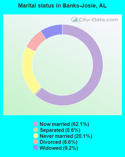
- Never married: 20.1%
- Now married: 62.1%
- Separated: 0.6%
- Widowed: 9.2%
- Divorced: 8.6%
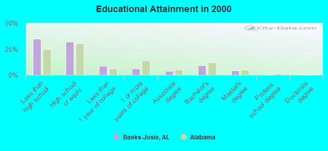
For population 25 years and over in Banks-Josie:
- High school or higher: 65.0%
- Bachelor's degree or higher: 14.1%
- Graduate or professional degree: 5.1%
- Unemployed: 5.2%
- Mean travel time to work (commute): 31.2 minutes
| Here: | 14.9 |
| Alabama average: | 13.2 |
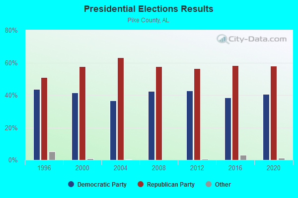
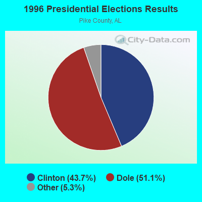
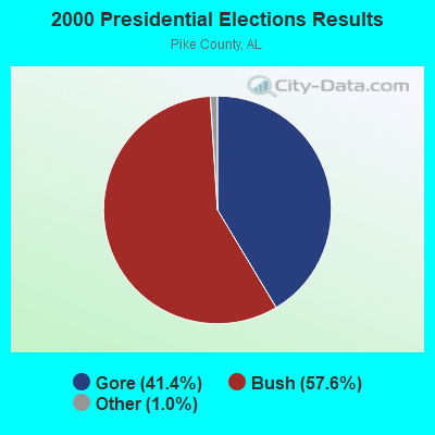

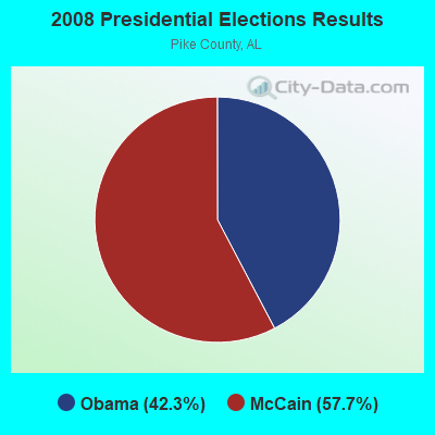
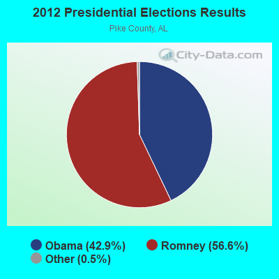
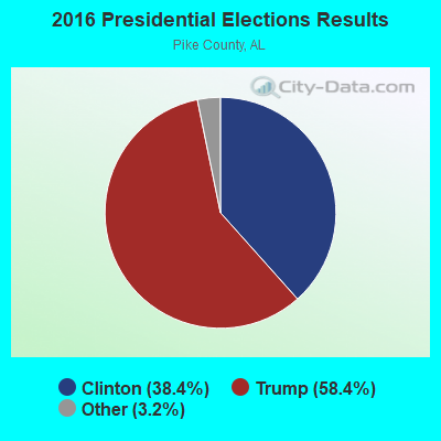
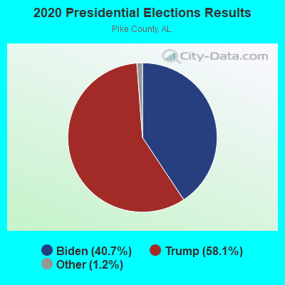
Graphs represent county-level data. Detailed 2008 Election Results
Religion statistics for Banks-Josie, AL (based on Pike County data)
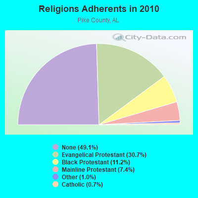
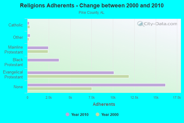
| Religion | Adherents | Congregations |
|---|---|---|
| Evangelical Protestant | 10,098 | 52 |
| Black Protestant | 3,675 | 19 |
| Mainline Protestant | 2,442 | 14 |
| Other | 325 | 3 |
| Catholic | 215 | 1 |
| None | 16,144 | - |
Food Environment Statistics:
| This county: | 2.65 / 10,000 pop. |
| State: | 1.89 / 10,000 pop. |
| Pike County: | 0.33 / 10,000 pop. |
| State: | 0.20 / 10,000 pop. |
| This county: | 0.66 / 10,000 pop. |
| State: | 0.65 / 10,000 pop. |
| Pike County: | 5.30 / 10,000 pop. |
| Alabama: | 6.32 / 10,000 pop. |
| This county: | 5.63 / 10,000 pop. |
| Alabama: | 5.75 / 10,000 pop. |
| This county: | 12.2% |
| Alabama: | 11.8% |
| This county: | 36.7% |
| Alabama: | 31.7% |
| This county: | 14.4% |
| State: | 13.5% |
Strongest AM radio stations in Banks-Josie:
- WTBF (970 AM; 5 kW; TROY, AL; Owner: TROY BROADCASTING CORP.)
- WQLS (1200 AM; 10 kW; OZARK, AL; Owner: STYLES BROADCASTING OF DOTHAN, INC.)
- WMSP (740 AM; 10 kW; MONTGOMERY, AL; Owner: CUMULUS LICENSING CORP.)
- WJOX (690 AM; 50 kW; BIRMINGHAM, AL; Owner: CITADEL BROADCASTING COMPANY)
- WACV (1170 AM; 10 kW; MONTGOMERY, AL; Owner: MONTGOMERY BROADCAST PROPERTIES, LTD)
- WOOF (560 AM; 5 kW; DOTHAN, AL; Owner: WOOF, INC.)
- WDJC (850 AM; 50 kW; BIRMINGHAM, AL; Owner: KIMTRON, INC.)
- WGST (640 AM; 50 kW; ATLANTA, GA; Owner: CITICASTERS LICENSES, L.P.)
- WNSI (810 AM; 50 kW; JACKSONVILLE, AL; Owner: UNITED BROADCASTING NETWORK, INC.)
- WASG (550 AM; 25 kW; ATMORE, AL; Owner: 550 AM, INC)
- WMAC (940 AM; 50 kW; MACON, GA; Owner: CUMULUS LICENSING CORP.)
- WKNG (1060 AM; daytime; 50 kW; TALLAPOOSA, GA; Owner: WKNG, INC.)
- WAPI (1070 AM; 50 kW; BIRMINGHAM, AL; Owner: CITADEL BROADCASTING COMPANY)
Strongest FM radio stations in Banks-Josie:
- WTBF-FM (94.7 FM; BRUNDIDGE, AL; Owner: TROY BROADCASTING CORPORATION)
- WQLD (104.3 FM; LUVERNE, AL; Owner: CAPSTAR TX LIMITED PARTNERSHIP)
- WZHT (105.7 FM; TROY, AL; Owner: CAPSTAR TX LIMITED PARTNERSHIP)
- WAXU (91.1 FM; TROY, AL; Owner: AMERICAN FAMILY ASSOCIATION)
- WTSU (89.9 FM; MONTGOMERY-TROY, AL; Owner: TROY STATE UNIVERSITY)
- WLWI-FM (92.3 FM; MONTGOMERY, AL; Owner: CUMULUS LICENSING CORP.)
- WKMX (106.7 FM; ENTERPRISE, AL; Owner: WKMX, INC.)
- WBAM-FM (98.9 FM; MONTGOMERY, AL; Owner: DEEP SOUTH BROADCASTING COMPANY)
- WHHY-FM (101.9 FM; MONTGOMERY, AL; Owner: CUMULUS LICENSING CORP.)
- WZTZ (101.1 FM; ELBA, AL; Owner: ELBA RADIO COMPANY)
- WAOQ (100.3 FM; BRANTLEY, AL; Owner: ALATRON CORPORATION, INC.)
TV broadcast stations around Banks-Josie:
- WRJM-TV (Channel 67; TROY, AL; Owner: JOSIE PARK BROADCASTING, INC.)
- WSFA (Channel 12; MONTGOMERY, AL; Owner: LIBCO, INC.)
- WCOV-TV (Channel 20; MONTGOMERY, AL; Owner: WOODS COMMUNICATIONS CORPORATION)
- WGIQ (Channel 43; LOUISVILLE, AL; Owner: ALABAMA EDUCATIONAL TELEVISION COMMISSION)
- WNCF (Channel 32; MONTGOMERY, AL; Owner: CHANNEL 32 MONTGOMERY LLC)
- WDIQ (Channel 2; DOZIER, AL; Owner: ALABAMA EDUCATIONAL TELEVISION COMMISSION)
- WMCF-TV (Channel 45; MONTGOMERY, AL; Owner: TRINITY BROADCASTING NETWORK)
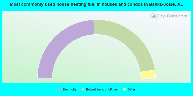
- 48.5%Electricity
- 46.9%Bottled, tank, or LP gas
- 2.3%Wood
- 1.7%No fuel used
- 0.6%Fuel oil, kerosene, etc.
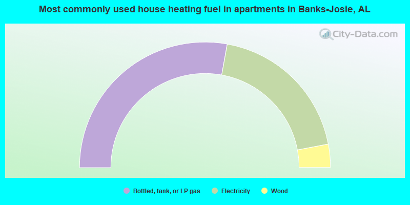
- 55.7%Bottled, tank, or LP gas
- 38.3%Electricity
- 6.0%Wood
Banks-Josie compared to Alabama state average:
- Unemployed percentage below state average.
- Hispanic race population percentage significantly below state average.
- Median age below state average.
- Foreign-born population percentage significantly below state average.
- Renting percentage below state average.
- Length of stay since moving in significantly above state average.
- Number of rooms per house significantly below state average.
- House age significantly below state average.