Bennett, Wisconsin
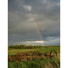
Bennett: A rainbow an old piece of farm machinery, in Bennett, WI.
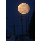
Bennett: Moon Rise in Bennett WI
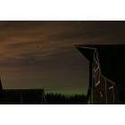
Bennett: Northern Lights over a barn in Bennett WI
- add
your


Submit your own pictures of this town and show them to the world
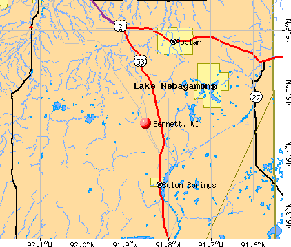
- OSM Map
- General Map
- Google Map
- MSN Map
Population change since 2000: -4.0%
 |
| Males: 308 | |
| Females: 289 |
| Median resident age: | 45.6 years |
| Wisconsin median age: | 42.6 years |
Zip codes: 54849.
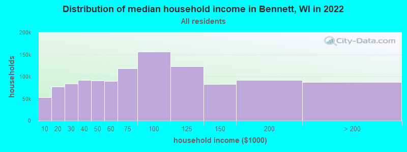
| Bennett: | $72,529 |
| WI: | $70,996 |
Estimated per capita income in 2022: $37,108 (it was $18,335 in 2000)
Bennett town income, earnings, and wages data
Estimated median house or condo value in 2022: $222,111 (it was $82,300 in 2000)
| Bennett: | $222,111 |
| WI: | $252,800 |
Mean prices in 2022: all housing units: $201,945; detached houses: $209,055; townhouses or other attached units: $212,805; in 2-unit structures: $185,551; mobile homes: $81,636; occupied boats, rvs, vans, etc.: $123,010
Detailed information about poverty and poor residents in Bennett, WI
Compare current foreclosures near Bennett, WI:
| Photo | Address | Area | Beds / Baths | Price | Details |
|---|---|---|---|---|---|

|
#1
S Jackson Rd
Lake Nebagamon, WI 54849
|
1,332 sq. feet
|
2 baths 3 beds |
show details | |

|
#2
E Spaulding Rd
South Range, WI 54874
|
- sq. feet
|
1 baths 3 beds |
show details | |

|
#3
E Minnesuing Acres Dr
Lake Nebagamon, WI 54849
|
- sq. feet
|
- baths - beds |
show details | |

|
#4
S Steele Lake Rd
Lake Nebagamon, WI 54849
|
- sq. feet
|
- baths - beds |
show details | |

|
#5
S Tuff Rd
Superior, WI 54880
|
- sq. feet
|
- baths - beds |
show details | |

|
#6
S State Road 35
Superior, WI 54880
|
- sq. feet
|
- baths - beds |
show details | |

|
#7
E County Road B
Lake Nebagamon, WI 54849
|
- sq. feet
|
- baths - beds |
show details | |

|
#8
E 3rd St N
Lake Nebagamon, WI 54849
|
- sq. feet
|
- baths - beds |
show details | |

|
#9
E West Lakeview Rd
Poplar, WI 54864
|
- sq. feet
|
- baths - beds |
show details | |

|
#10
E County Road C
South Range, WI 54874
|
- sq. feet
|
- baths - beds |
show details |
| Photo | Address | Area | Beds / Baths | Price | Details |
|---|---|---|---|---|---|

|
#11
Broken Arrow Trl
Solon Springs, WI 54873
|
- sq. feet
|
- baths - beds |
show details | |

|
Check over 1 million property listings on Foreclosure.com!
|
browse all offers | |||

- 56895.1%White alone
- 132.2%Two or more races
- 81.3%Hispanic
- 71.2%American Indian alone
- 10.2%Black alone
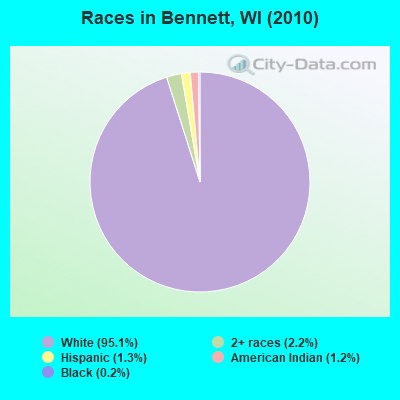
Races in Bennett detailed stats: ancestries, foreign born residents, place of birth
 Recent articles from our blog. Our writers, many of them Ph.D. graduates or candidates, create easy-to-read articles on a wide variety of topics.


 | Wisconsin Dells Trip (8 replies) |
| Scott Walker officially running for President on Monday (117 replies) |
| Mercury vote - Fond du lac (45 replies) |
Latest news from Bennett, WI collected exclusively by city-data.com from local newspapers, TV, and radio stations
Ancestries: German (25.6%), Swedish (20.7%), Norwegian (15.1%), Irish (11.6%), English (8.7%), Polish (7.4%).
Current Local Time: CST time zone
Elevation: 1200 feet
Land area: 47.5 square miles.
Population density: 13 people per square mile (very low).
7 residents are foreign born
| This town: | 1.1% |
| Wisconsin: | 3.6% |
| Bennett town: | 1.4% ($1,135) |
| Wisconsin: | 2.0% ($2,245) |
Nearest city with pop. 50,000+: Duluth, MN  (27.2 miles , pop. 86,918).
Nearest city with pop. 200,000+: St. Paul, MN (121.5 miles , pop. 287,151).
Nearest city with pop. 1,000,000+: Chicago, IL (378.9 miles , pop. 2,896,016).
Nearest cities:
), ), ), ), Latitude: 46.45 N, Longitude: 91.80 W
Area code: 715

| Here: | 3.9% |
| Wisconsin: | 2.7% |
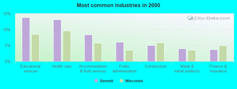
- Educational services (13.8%)
- Health care (13.1%)
- Accommodation & food services (8.4%)
- Public administration (6.1%)
- Construction (5.1%)
- Metal & metal products (4.0%)
- Finance & insurance (3.7%)
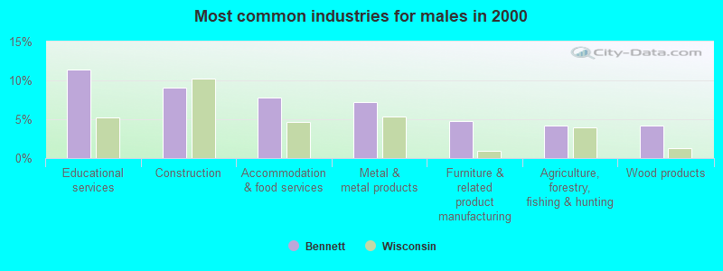
- Educational services (11.4%)
- Construction (9.0%)
- Accommodation & food services (7.8%)
- Metal & metal products (7.2%)
- Furniture & related product manufacturing (4.8%)
- Agriculture, forestry, fishing & hunting (4.2%)
- Wood products (4.2%)
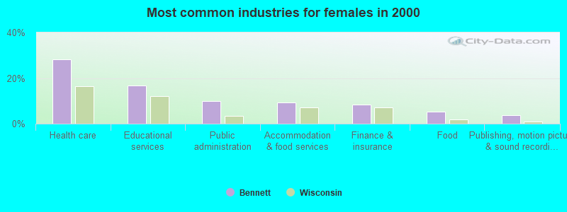
- Health care (28.2%)
- Educational services (16.8%)
- Public administration (9.9%)
- Accommodation & food services (9.2%)
- Finance & insurance (8.4%)
- Food (5.3%)
- Publishing, motion picture & sound recording industries (3.8%)
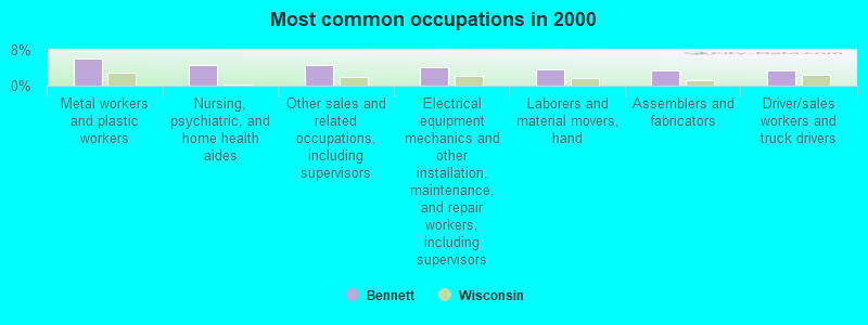
- Metal workers and plastic workers (6.1%)
- Nursing, psychiatric, and home health aides (4.7%)
- Other sales and related occupations, including supervisors (4.7%)
- Electrical equipment mechanics and other installation, maintenance, and repair workers, including supervisors (4.0%)
- Laborers and material movers, hand (3.7%)
- Assemblers and fabricators (3.4%)
- Driver/sales workers and truck drivers (3.4%)
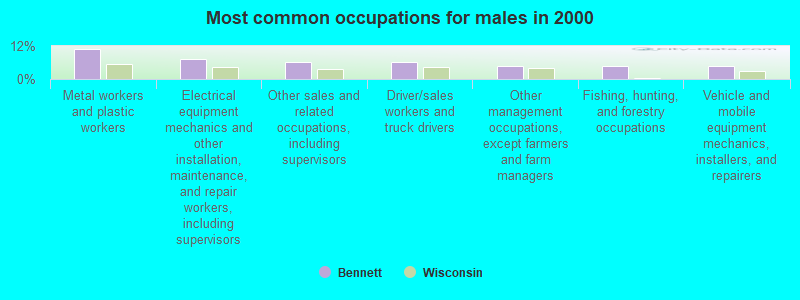
- Metal workers and plastic workers (10.8%)
- Electrical equipment mechanics and other installation, maintenance, and repair workers, including supervisors (7.2%)
- Other sales and related occupations, including supervisors (6.0%)
- Driver/sales workers and truck drivers (6.0%)
- Other management occupations, except farmers and farm managers (4.8%)
- Fishing, hunting, and forestry occupations (4.8%)
- Vehicle and mobile equipment mechanics, installers, and repairers (4.8%)

- Nursing, psychiatric, and home health aides (10.7%)
- Registered nurses (5.3%)
- Cooks and food preparation workers (5.3%)
- Information and record clerks, except customer service representatives (4.6%)
- Other financial specialists (4.6%)
- Laborers and material movers, hand (3.8%)
- Bus drivers (3.8%)
Average climate in Bennett, Wisconsin
Based on data reported by over 4,000 weather stations


Tornado activity:
Bennett-area historical tornado activity is significantly below Wisconsin state average. It is 69% smaller than the overall U.S. average.
On 9/3/1980, a category F2 (max. wind speeds 113-157 mph) tornado 9.5 miles away from the Bennett town center caused between $5000 and $50,000 in damages.
On 6/11/1966, a category F4 (max. wind speeds 207-260 mph) tornado 55.4 miles away from the town center caused between $50,000 and $500,000 in damages.
Earthquake activity:
Bennett-area historical earthquake activity is significantly above Wisconsin state average. It is 67% smaller than the overall U.S. average.On 7/9/1975 at 14:54:15, a magnitude 4.6 (4.6 MB, Class: Light, Intensity: IV - V) earthquake occurred 210.5 miles away from the city center
On 6/5/1993 at 01:24:53, a magnitude 4.1 (4.1 LG, Depth: 6.2 mi) earthquake occurred 222.2 miles away from Bennett center
On 2/7/2020 at 18:30:28, a magnitude 3.3 (3.3 ML, Class: Light, Intensity: II - III) earthquake occurred 83.3 miles away from the city center
On 1/9/2020 at 18:16:48, a magnitude 3.3 (3.3 MB) earthquake occurred 86.3 miles away from Bennett center
On 4/8/2020 at 17:14:33, a magnitude 3.3 (3.3 ML) earthquake occurred 86.8 miles away from the city center
On 3/2/2017 at 16:53:31, a magnitude 3.2 (3.2 ML) earthquake occurred 81.9 miles away from Bennett center
Magnitude types: regional Lg-wave magnitude (LG), body-wave magnitude (MB), local magnitude (ML)
Natural disasters:
The number of natural disasters in Douglas County (9) is smaller than the US average (15).Major Disasters (Presidential) Declared: 7
Emergencies Declared: 2
Causes of natural disasters: Floods: 6, Storms: 4, Winds: 2, Drought: 1, Heavy Rain: 1, Hurricane: 1, Other: 1 (Note: some incidents may be assigned to more than one category).

Colleges/universities with over 2000 students nearest to Bennett:
- University of Wisconsin-Superior (about 23 miles; Superior, WI; Full-time enrollment: 2,302)
- Lake Superior College (about 29 miles; Duluth, MN; FT enrollment: 3,768)
- University of Minnesota-Duluth (about 29 miles; Duluth, MN; FT enrollment: 10,612)
- The College of Saint Scholastica (about 29 miles; Duluth, MN; FT enrollment: 3,762)
- Wisconsin Indianhead Technical College (about 50 miles; Shell Lake, WI; FT enrollment: 2,414)
- University of Wisconsin-Stout (about 109 miles; Menomonie, WI; FT enrollment: 8,120)
- Century College (about 114 miles; White Bear Lake, MN; FT enrollment: 7,393)
Points of interest:
Notable location: Bennett Volunteer Fire Department (A). Display/hide its location on the map
Church in Bennett: Emmanuel Church (A). Display/hide its location on the map
Cemetery: Bennett Cemetery (1). Display/hide its location on the map
Lakes and swamps: Coffee Lake (A), Cream Lake (B), Gander Lake (C), Lake Minnesuing (D), Moose Lake (E), Merriam Swamp (F). Display/hide their locations on the map
Park in Bennett: Lake Minnesuing County Park (1). Display/hide its location on the map
| This town: | 2.5 people |
| Wisconsin: | 2.4 people |
| This town: | 68.3% |
| Whole state: | 64.4% |
| This town: | 7.9% |
| Whole state: | 7.3% |
Likely homosexual households (counted as self-reported same-sex unmarried-partner households)
- Lesbian couples: 0.8% of all households
- Gay men: 1.2% of all households
| This town: | 7.7% |
| Whole state: | 8.7% |
| This town: | 2.4% |
| Whole state: | 3.7% |
For population 15 years and over in Bennett:
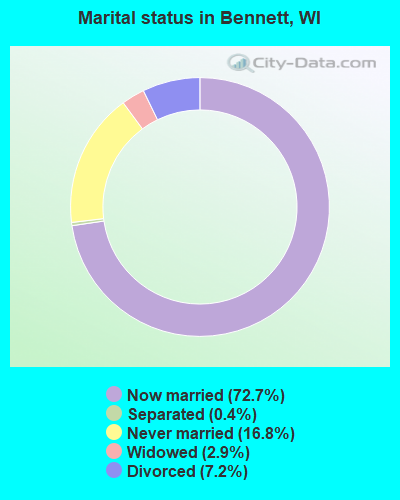
- Never married: 16.8%
- Now married: 72.7%
- Separated: 0.4%
- Widowed: 2.9%
- Divorced: 7.2%
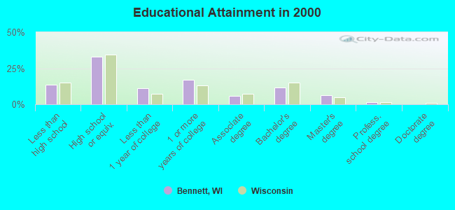
For population 25 years and over in Bennett:
- High school or higher: 86.5%
- Bachelor's degree or higher: 19.5%
- Graduate or professional degree: 7.8%
- Unemployed: 7.2%
- Mean travel time to work (commute): 34.1 minutes
| Here: | 9.4 |
| Wisconsin average: | 11.0 |
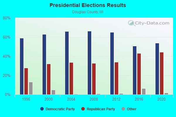
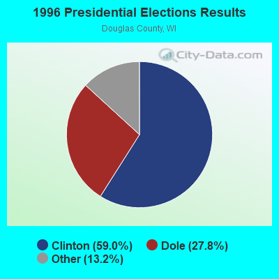
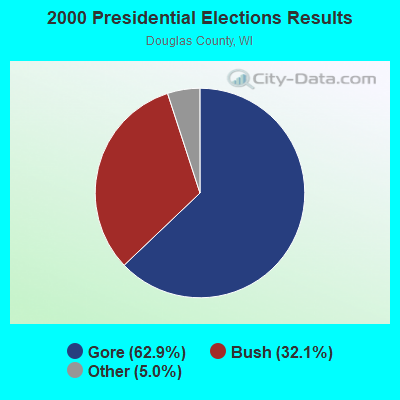
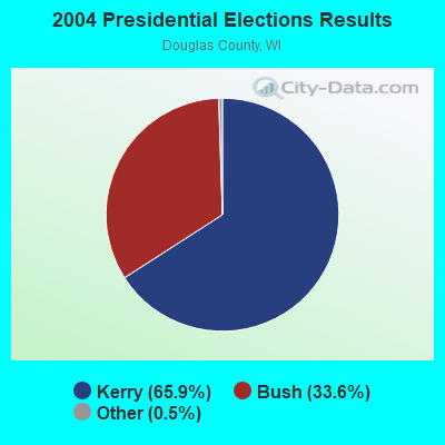
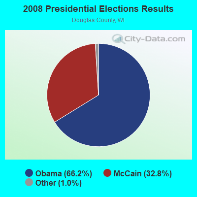
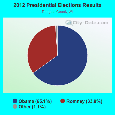
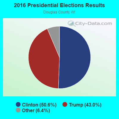
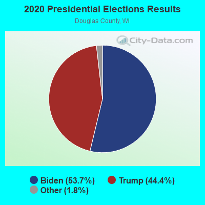
Graphs represent county-level data. Detailed 2008 Election Results
Religion statistics for Bennett, WI (based on Douglas County data)
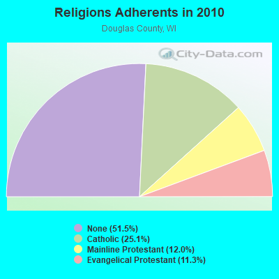
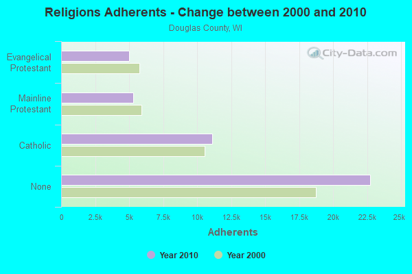
| Religion | Adherents | Congregations |
|---|---|---|
| Catholic | 11,104 | 8 |
| Mainline Protestant | 5,290 | 16 |
| Evangelical Protestant | 5,012 | 29 |
| Other | 14 | 2 |
| None | 22,739 | - |
Food Environment Statistics:
| Douglas County: | 2.06 / 10,000 pop. |
| State: | 1.86 / 10,000 pop. |
| Douglas County: | 0.46 / 10,000 pop. |
| Wisconsin: | 0.38 / 10,000 pop. |
| This county: | 5.26 / 10,000 pop. |
| Wisconsin: | 4.12 / 10,000 pop. |
| Douglas County: | 9.15 / 10,000 pop. |
| Wisconsin: | 8.64 / 10,000 pop. |
| Douglas County: | 7.9% |
| Wisconsin: | 7.6% |
| Douglas County: | 27.0% |
| Wisconsin: | 27.5% |
| This county: | 14.5% |
| Wisconsin: | 13.0% |
Strongest AM radio stations in Bennett:
- WEBC (560 AM; 50 kW; DULUTH, MN)
- WDSM (710 AM; 10 kW; SUPERIOR, WI; Owner: MIDWEST COMMUNICATIONS, INC.)
- WWJC (850 AM; daytime; 10 kW; DULUTH, MN; Owner: WWJC, INC.)
- KDAL (610 AM; 5 kW; DULUTH, MN; Owner: MIDWEST COMMUNICATIONS, INC.)
- WHSM (910 AM; 5 kW; HAYWARD, WI; Owner: QB BROADCASTING, LTD.)
- WCCO (830 AM; 50 kW; MINNEAPOLIS, MN; Owner: INFINITY MEDIA CORPORATION)
- WCTS (1030 AM; 50 kW; MAPLEWOOD, MN; Owner: CNTL. BAPT. THEO/AL SEMI MINNEAPOLIS)
- KSTP (1500 AM; 50 kW; ST. PAUL, MN; Owner: KSTP-AM, LLC (DELAWARE))
- KFAN (1130 AM; 50 kW; MINNEAPOLIS, MN; Owner: AMFM RADIO LICENSES, L.L.C.)
- KTIS (900 AM; 25 kW; MINNEAPOLIS, MN; Owner: NORTHWESTERN COLLEGE)
- WNMT (650 AM; 10 kW; NASHWAUK, MN; Owner: MIDWEST RADIO NETWORK, L.L.C.)
- WGEE (970 AM; 1 kW; SUPERIOR, WI; Owner: MIDWEST COMMUNICATIONS, INC.)
- WSPT (1010 AM; 50 kW; STEVENS POINT, WI)
Strongest FM radio stations in Bennett:
- WHSA (89.9 FM; BRULE, WI; Owner: STATE OF WISCONSIN - EDUCATIONAL COMMUNICATIONS BOARD)
- KBMX (107.7 FM; PROCTOR, MN; Owner: REGENT BROADCASTING OF DULUTH, INC.)
- WWAX (92.1 FM; HERMANTOWN, MN; Owner: RED ROCK RADIO CORP.)
- WSCN (100.5 FM; CLOQUET, MN; Owner: MINNESOTA PUBLIC RADIO)
- KDNI (90.5 FM; DULUTH, MN; Owner: NORTHWESTERN COLLEGE)
- KQDS-FM (94.9 FM; DULUTH, MN; Owner: RED ROCK RADIO CORP.)
- KLDJ (101.7 FM; DULUTH, MN; Owner: REGENT BROADCASTING OF DULUTH, INC.)
- KDAL-FM (95.7 FM; DULUTH, MN; Owner: MIDWEST COMMUNICATIONS, INC.)
- KUMD-FM (103.3 FM; DULUTH, MN; Owner: REGENTS OF UNIVERSITY OF MINNESOTA)
- KKCB (105.1 FM; DULUTH, MN; Owner: REGENT BROADCASTING OF DULUTH, INC.)
- KUWS (91.3 FM; SUPERIOR, WI; Owner: BD. OF REGENTS, UNIV. OF WISC. SYS.)
- WSCD-FM (92.9 FM; DULUTH, MN; Owner: MINNESOTA PUBLIC RADIO)
- KRBR-FM (102.5 FM; SUPERIOR, WI; Owner: MIDWEST COMMUNICATIONS, INC.)
- KTCO (98.9 FM; DULUTH, MN; Owner: MIDWEST COMMUNICATIONS, INC.)
- KDNW (97.3 FM; DULUTH, MN; Owner: NORTHWESTERN COLLEGE)
- WNCB (89.5 FM; DULUTH, MN; Owner: REFUGE MEDIA GROUP)
- WNXR (107.3 FM; IRON RIVER, WI; Owner: GERALD J. HACKMAN)
TV broadcast stations around Bennett:
- WDIO-TV (Channel 10; DULUTH, MN; Owner: WDIO-TV, LLC)
- KDLH (Channel 3; DULUTH, MN; Owner: CHELSEY BROADCASTING COMPANY OF DULUTH, LLC)
- KBJR-TV (Channel 6; SUPERIOR, WI; Owner: KBJR LICENSE, INC.)
- KQDS-TV (Channel 21; DULUTH, MN; Owner: KQDS ACQUISITION CORP.)
- WDSE-TV (Channel 8; DULUTH, MN; Owner: DULUTH-SUPERIOR AREA EDUCATIONAL TV CORPORATION)
- K58CM (Channel 58; DULUTH, MN; Owner: TRINITY BROADCASTING NETWORK)
FCC Registered Cell Phone Towers:
1 (See the full list of FCC Registered Cell Phone Towers in Bennett)FCC Registered Antenna Towers:
21 (See the full list of FCC Registered Antenna Towers)FCC Registered Microwave Towers:
4- BENNETT, 9402 Pison Rd (Lat: 46.423333 Lon: -91.878611), Type: Tower, Structure height: 91.4 m, Overall height: 96.9 m, Call Sign: WQMD226,
Assigned Frequencies: 6805.00 MHz, Grant Date: 04/16/2020, Expiration Date: 07/01/2030, Certifier: Gene Purcell, Registrant: Gray Miller Persh LLC, 2233 Wisconsin Av Nw, Suite 226, Washington, DC 20007, Phone: (202) 776-2458, Email:
- BENNETT, 9402 Pison Rd (Lat: 46.423333 Lon: -91.878611), Type: Tower, Structure height: 91.4 m, Overall height: 96.9 m, Call Sign: WQMQ438,
Assigned Frequencies: 10835.0 MHz, 10865.0 MHz, 10905.0 MHz, Grant Date: 09/22/2020, Expiration Date: 10/21/2030, Certifier: Tom Dalbec, Registrant: Dsc Communications, 711 Hammond Ave, Superior, WI 54880, Phone: (715) 392-2911, Fax: (715) 392-2995, Email:
- BENNETT, County Road L And Maki Road (Lat: 46.446861 Lon: -91.870444), Type: Tower, Structure height: 68.6 m, Overall height: 75.6 m, Call Sign: WQPJ873,
Assigned Frequencies: 6093.45 MHz, 5945.20 MHz, Grant Date: 05/03/2022, Expiration Date: 06/07/2032, Certifier: Gregory M Romano, Registrant: Verizon, 5055 Northpointe Pkwy, Alpharetta, GA 30022, Phone: (770) 797-1070, Email:
- BENNETT, 9402 Pison Rd (Lat: 46.423250 Lon: -91.878500), Type: Gtower, Structure height: 91.4 m, Overall height: 96.9 m, Call Sign: WAP54,
Assigned Frequencies: 6775.00 MHz, 6745.00 MHz, 6845.00 MHz, 6845.00 MHz, 6845.00 MHz, 6845.00 MHz, 6109.51 MHz, Grant Date: 05/02/2018, Expiration Date: 07/13/2028, Registrant: Wisconsin State Patrol, 4822 Madison Yards Way - 9th Fl South, Madison, WI 53705, Phone: (608) 709-0095, Email:
FCC Registered Amateur Radio Licenses:
11 (See the full list of FCC Registered Amateur Radio Licenses in Bennett)FAA Registered Aircraft:
1- Aircraft: DESTINY XLT (Category: Land, Seats: 2, Weight: Up to 12,499 Pounds), Engine: ROTAX 582DCDI (65 HP) (2 Cycle)
N-Number: 3519M, N3519M, N-3519M, Serial Number: 1CO281, Year manufactured: 2007, Airworthiness Date: 10/27/2007, Certificate Issue Date: 08/22/2007
Registrant (Individual): Philip F Larson, 8915 E Peterson Rd, Bennett, WI 54873
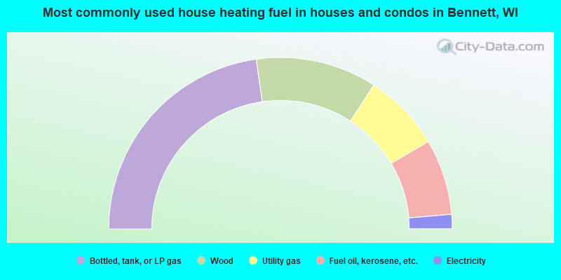
- 45.5%Bottled, tank, or LP gas
- 22.8%Wood
- 14.7%Utility gas
- 14.3%Fuel oil, kerosene, etc.
- 2.7%Electricity
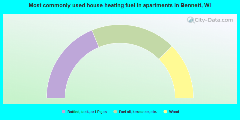
- 37.5%Bottled, tank, or LP gas
- 37.5%Fuel oil, kerosene, etc.
- 25.0%Wood
Bennett compared to Wisconsin state average:
- Unemployed percentage below state average.
- Black race population percentage significantly below state average.
- Hispanic race population percentage significantly below state average.
- Foreign-born population percentage significantly below state average.
- Renting percentage significantly below state average.
- Length of stay since moving in significantly above state average.
- Number of rooms per house significantly below state average.
- House age significantly below state average.
State forum archive: