Bethesda, Tennessee
Submit your own pictures of this place and show them to the world
- OSM Map
- General Map
- Google Map
- MSN Map

| Males: 3,349 | |
| Females: 3,348 |
| Median resident age: | 39.0 years |
| Tennessee median age: | 35.9 years |
Zip code: 37046
| Bethesda: | $66,141 |
| TN: | $65,254 |
Estimated per capita income in 2022: $33,710 (it was $16,457 in 2000)
Bethesda CCD income, earnings, and wages data
Estimated median house or condo value in 2022: $240,102 (it was $84,300 in 2000)
| Bethesda: | $240,102 |
| TN: | $284,800 |
Mean prices in 2022: all housing units: $307,004; detached houses: $342,036; townhouses or other attached units: $261,680; in 2-unit structures: $230,734; in 3-to-4-unit structures: $256,241; in 5-or-more-unit structures: $225,551; mobile homes: $66,811
Detailed information about poverty and poor residents in Bethesda, TN


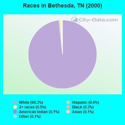
- 6,06298.3%White alone
- 340.6%Hispanic
- 320.5%Two or more races
- 160.3%Black alone
- 90.1%American Indian alone
- 80.1%Asian alone
- 70.1%Other race alone
Races in Bethesda detailed stats: ancestries, foreign born residents, place of birth
 Recent articles from our blog. Our writers, many of them Ph.D. graduates or candidates, create easy-to-read articles on a wide variety of topics.

Current Local Time: EST time zone
Land area: 58.5 square miles.
Population density: 114 people per square mile (very low).
| Bethesda CCD: | 0.5% ($427) |
| Tennessee: | 0.8% ($715) |
Nearest city with pop. 50,000+: Johnson City, TN  (9.8 miles , pop. 55,469).
Nearest city with pop. 200,000+: Charlotte, NC (115.4 miles , pop. 540,828).
Nearest city with pop. 1,000,000+: Philadelphia, PA (476.4 miles , pop. 1,517,550).
Nearest cities:
)Latitude: 36.22 N, Longitude: 82.47 W
Area code commonly used in this area: 423

| Here: | 3.0% |
| Tennessee: | 3.0% |
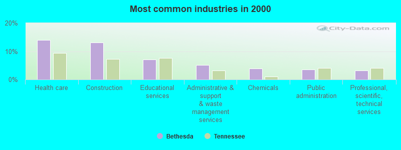
- Health care (14.1%)
- Construction (13.1%)
- Educational services (7.1%)
- Administrative & support & waste management services (5.2%)
- Chemicals (3.9%)
- Public administration (3.6%)
- Professional, scientific, technical services (3.3%)
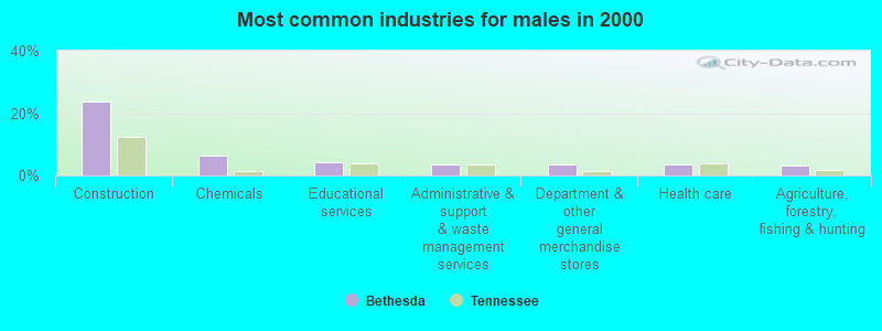
- Construction (23.7%)
- Chemicals (6.3%)
- Educational services (4.3%)
- Administrative & support & waste management services (3.5%)
- Department & other general merchandise stores (3.5%)
- Health care (3.5%)
- Agriculture, forestry, fishing & hunting (3.4%)
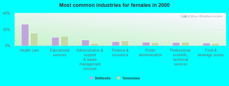
- Health care (26.4%)
- Educational services (10.4%)
- Administrative & support & waste management services (7.1%)
- Finance & insurance (5.1%)
- Public administration (4.3%)
- Professional, scientific, technical services (4.0%)
- Food & beverage stores (3.0%)
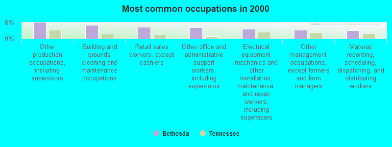
- Other production occupations, including supervisors (6.0%)
- Building and grounds cleaning and maintenance occupations (5.0%)
- Retail sales workers, except cashiers (4.4%)
- Other office and administrative support workers, including supervisors (4.2%)
- Electrical equipment mechanics and other installation, maintenance, and repair workers, including supervisors (3.7%)
- Other management occupations, except farmers and farm managers (3.3%)
- Material recording, scheduling, dispatching, and distributing workers (3.1%)
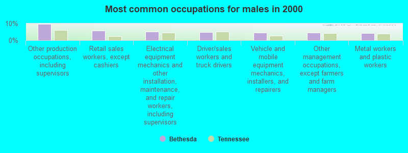
- Other production occupations, including supervisors (9.7%)
- Retail sales workers, except cashiers (5.7%)
- Electrical equipment mechanics and other installation, maintenance, and repair workers, including supervisors (5.2%)
- Driver/sales workers and truck drivers (5.0%)
- Vehicle and mobile equipment mechanics, installers, and repairers (4.6%)
- Other management occupations, except farmers and farm managers (4.5%)
- Metal workers and plastic workers (4.3%)
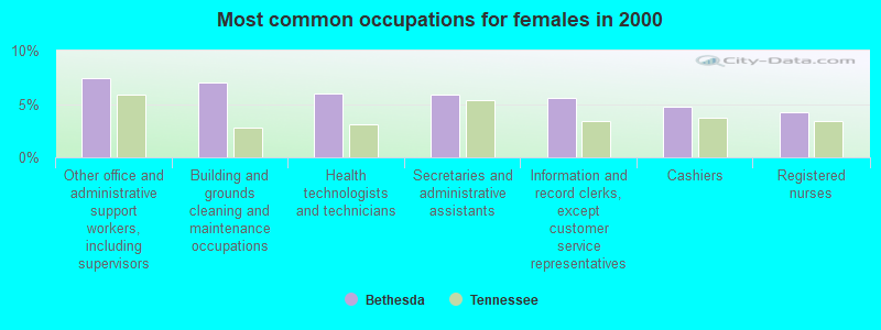
- Other office and administrative support workers, including supervisors (7.4%)
- Building and grounds cleaning and maintenance occupations (7.0%)
- Health technologists and technicians (6.0%)
- Secretaries and administrative assistants (5.9%)
- Information and record clerks, except customer service representatives (5.6%)
- Cashiers (4.8%)
- Registered nurses (4.3%)
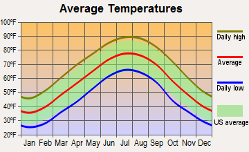
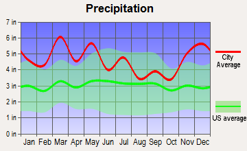
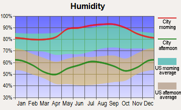
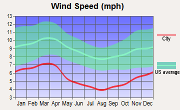
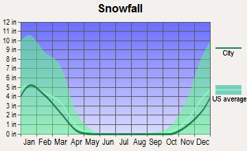
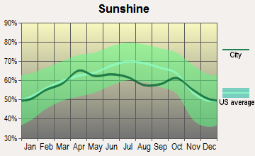
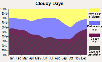
Average climate in Bethesda, Tennessee
Based on data reported by over 4,000 weather stations
(lower is better)
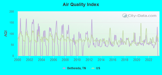
Air Quality Index (AQI) level in 2022 was 52.1. This is better than average.
| City: | 52.1 |
| U.S.: | 72.6 |
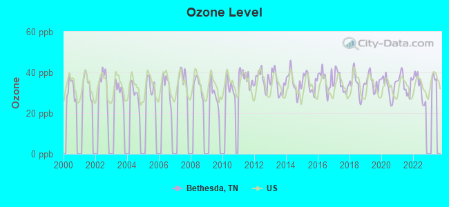
Ozone [ppb] level in 2022 was 32.9. This is about average. Closest monitor was 22.4 miles away from the city center.
| City: | 32.9 |
| U.S.: | 33.3 |
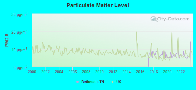
Particulate Matter (PM2.5) [µg/m3] level in 2022 was 6.10. This is better than average. Closest monitor was 22.5 miles away from the city center.
| City: | 6.10 |
| U.S.: | 8.11 |
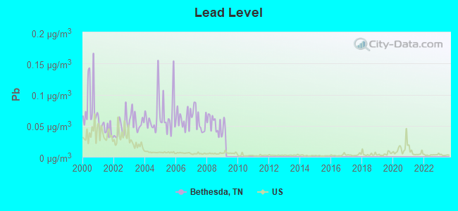
Lead (Pb) [µg/m3] level in 2008 was 0.0520. This is significantly worse than average. Closest monitor was 9.5 miles away from the city center.
| City: | 0.0520 |
| U.S.: | 0.0093 |
Tornado activity:
Bethesda-area historical tornado activity is significantly below Tennessee state average. It is 66% smaller than the overall U.S. average.
On 7/10/1980, a category F3 (max. wind speeds 158-206 mph) tornado 6.6 miles away from the Bethesda place center injured 12 people and caused between $50,000 and $500,000 in damages.
On 4/8/1957, a category F2 (max. wind speeds 113-157 mph) tornado 7.7 miles away from the place center caused between $500 and $5000 in damages.
Earthquake activity:
Bethesda-area historical earthquake activity is significantly above Tennessee state average. It is 28% greater than the overall U.S. average.On 8/9/2020 at 12:07:37, a magnitude 5.1 (5.1 MW, Depth: 4.7 mi, Class: Moderate, Intensity: VI - VII) earthquake occurred 78.6 miles away from Bethesda center
On 8/23/2011 at 17:51:04, a magnitude 5.8 (5.8 MW, Depth: 3.7 mi) earthquake occurred 276.1 miles away from the city center
On 7/27/1980 at 18:52:21, a magnitude 5.2 (5.1 MB, 4.7 MS, 5.0 UK, 5.2 UK) earthquake occurred 159.8 miles away from the city center
On 11/30/1973 at 07:48:41, a magnitude 4.7 (4.7 MB, 4.6 ML, Class: Light, Intensity: IV - V) earthquake occurred 88.5 miles away from Bethesda center
On 8/2/1974 at 08:52:09, a magnitude 4.9 (4.3 MB, 4.9 LG) earthquake occurred 162.1 miles away from Bethesda center
On 11/23/2006 at 10:42:57, a magnitude 4.3 (4.3 MB) earthquake occurred 70.6 miles away from the city center
Magnitude types: regional Lg-wave magnitude (LG), body-wave magnitude (MB), local magnitude (ML), surface-wave magnitude (MS), moment magnitude (MW)
Natural disasters:
The number of natural disasters in Washington County (9) is smaller than the US average (15).Major Disasters (Presidential) Declared: 5
Emergencies Declared: 2
Causes of natural disasters: Floods: 6, Storms: 5, Tornadoes: 2, Winds: 2, Heavy Rain: 1, Hurricane: 1, Snowfall: 1, Winter Storm: 1, Other: 1 (Note: some incidents may be assigned to more than one category).
Hospitals and medical centers near Bethesda:
- FOUR OAKS HEALTH CARE CENTER (Nursing Home, about 6 miles away; JONESBOROUGH, TN)
- JONESBOROUGH NH (Nursing Home, about 6 miles away; JONESBOROUGH, TN)
- COMCARE INC OBRIEN (Hospital, about 7 miles away; ERWIN, TN)
- UNICOI COUNTY HOME HEALTH (Home Health Center, about 7 miles away; ERWIN, TN)
- CENTER ON AGING AND HEALTH (Nursing Home, about 7 miles away; ERWIN, TN)
- ERWIN HEALTH CARE CENTER (Nursing Home, about 7 miles away; ERWIN, TN)
- LAKEBRIDGE HEALTH CARE CENTER (Nursing Home, about 8 miles away; JOHNSON CITY, TN)
Colleges/universities with over 2000 students nearest to Bethesda:
- East Tennessee State University (about 9 miles; Johnson City, TN; Full-time enrollment: 12,774)
- Tusculum College (about 17 miles; Greeneville, TN; FT enrollment: 2,070)
- Northeast State Community College (about 19 miles; Blountville, TN; FT enrollment: 4,480)
- King University (about 31 miles; Bristol, TN; FT enrollment: 2,472)
- University of North Carolina at Asheville (about 42 miles; Asheville, NC; FT enrollment: 3,312)
- Appalachian State University (about 44 miles; Boone, NC; FT enrollment: 17,362)
- Walters State Community College (about 45 miles; Morristown, TN; FT enrollment: 4,359)
Points of interest:
Notable locations in Bethesda: Pinnacle Mountain Lookout (A), Clarkville Iron Furnace Documentary Site (B), Unaka Ranger Station (C), Sally Hole (D), Embreeville Volunteer Fire Department (E). Display/hide their locations on the map
Churches in Bethesda include: Union Church (A), Vincent United Methodist Church (B), Bethel Church (C), Bethesda United Methodist Church (D), Cherokee Community Independent Freewill Baptist Church (E), Embreeville United Methodist Church (F), Embreeville Cove Baptist Church (G), Cherokee Mountain Baptist Church (H), Cherokee Church (I). Display/hide their locations on the map
Cemeteries: Young-Lyle-Strickland Cemetery (1), Union Cemetery (2), Stuart Cemetery (3), Slagle Cemetery (4), Pleasant View Cemetery (5), Old Embreeville Cemetery (6), Old Dutch Meeting House Cemetery (7). Display/hide their locations on the map
Lakes: Waller Pond (A), Walker Pond (B). Display/hide their locations on the map
Streams, rivers, and creeks: Lebanon Branch (A), Patty Creek (B), Straight Creek (C), Tellico Branch (D), Briar Creek (E), Bumpus Cove Creek (F), Jackson Creek (G), Deacon Creek (H), Dry Creek (I). Display/hide their locations on the map
Park in Bethesda: Unicoi Wildlife Management Area (1). Display/hide its location on the map
| This place: | 2.5 people |
| Tennessee: | 2.5 people |
| This place: | 69.6% |
| Whole state: | 69.8% |
| This place: | 3.8% |
| Whole state: | 4.2% |
Likely homosexual households (counted as self-reported same-sex unmarried-partner households)
- Lesbian couples: 0.2% of all households
- Gay men: 0.2% of all households
| This place: | 13.0% |
| Whole state: | 13.5% |
| This place: | 4.6% |
| Whole state: | 5.8% |
For population 15 years and over in Bethesda:
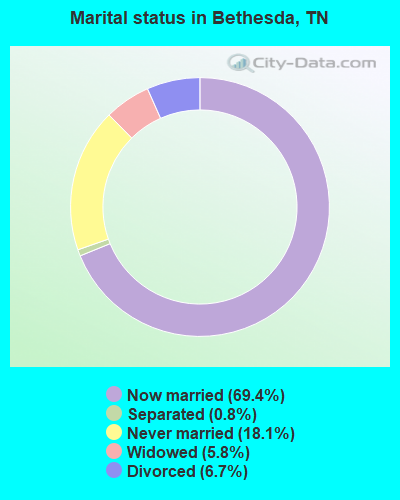
- Never married: 18.1%
- Now married: 69.4%
- Separated: 0.8%
- Widowed: 5.8%
- Divorced: 6.7%
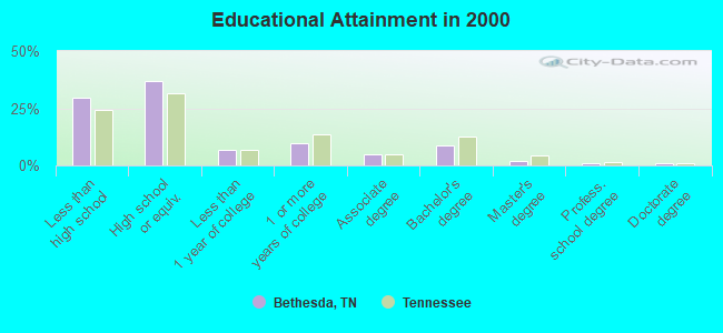
For population 25 years and over in Bethesda:
- High school or higher: 70.5%
- Bachelor's degree or higher: 12.4%
- Graduate or professional degree: 3.8%
- Unemployed: 3.3%
- Mean travel time to work (commute): 24.5 minutes
| Here: | 13.1 |
| Tennessee average: | 13.3 |
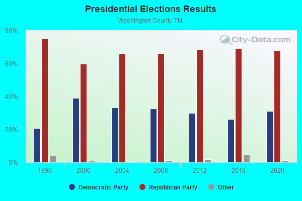
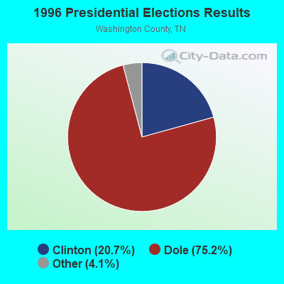


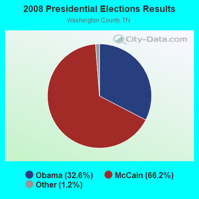
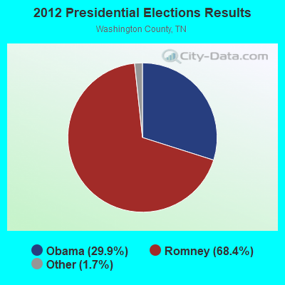
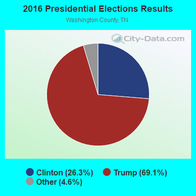

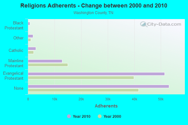
Graphs represent county-level data. Detailed 2008 Election Results
Religion statistics for Bethesda, TN (based on Washington County data)
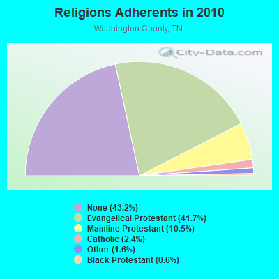
| Religion | Adherents | Congregations |
|---|---|---|
| Evangelical Protestant | 51,327 | 182 |
| Mainline Protestant | 12,877 | 50 |
| Catholic | 3,000 | 1 |
| Other | 1,924 | 8 |
| Black Protestant | 736 | 5 |
| Orthodox | 45 | 1 |
| None | 53,070 | - |
Food Environment Statistics:
| Washington County: | 1.72 / 10,000 pop. |
| Tennessee: | 1.99 / 10,000 pop. |
| Washington County: | 0.26 / 10,000 pop. |
| Tennessee: | 0.17 / 10,000 pop. |
| Here: | 0.09 / 10,000 pop. |
| State: | 0.65 / 10,000 pop. |
| Washington County: | 5.07 / 10,000 pop. |
| Tennessee: | 5.16 / 10,000 pop. |
| Washington County: | 8.16 / 10,000 pop. |
| Tennessee: | 6.56 / 10,000 pop. |
| Washington County: | 10.7% |
| Tennessee: | 11.4% |
| Here: | 29.0% |
| Tennessee: | 30.2% |
| Washington County: | 14.0% |
| Tennessee: | 13.5% |
Strongest AM radio stations in Bethesda:
- WKTP (1590 AM; 10 kW; JONESBOROUGH, TN; Owner: HOLSTON VALLEY BROADCASTING CORP.)
- WETB (790 AM; 5 kW; JOHNSON CITY, TN; Owner: MOUNTAIN SIGNALS, INC.)
- WEMB (1420 AM; 5 kW; ERWIN, TN; Owner: W E M B, INC.)
- WPWT (870 AM; daytime; 10 kW; COLONIAL HEIGHTS, TN; Owner: INFORMATION COMMUNICATIONS CORP.)
- WGOC (640 AM; 10 kW; BLOUNTVILLE, TN; Owner: CITADEL BROADCASTING COMPANY)
- WHGG (1090 AM; daytime; 10 kW; KINGSPORT, TN; Owner: APPALACHIAN EDUCATIONAL COMMUNICATIO)
- WJCW (910 AM; 5 kW; JOHNSON CITY, TN; Owner: CITADEL BROADCASTING COMPANY)
- WFGW (1010 AM; 50 kW; BLACK MOUNTAIN, NC; Owner: BLUE RIDGE BROADCASTING CORP.)
- WZAP (690 AM; 10 kW; BRISTOL, VA; Owner: RAM COMMUNICATIONS, INC.)
- WKJV (1380 AM; 25 kW; ASHEVILLE, NC; Owner: INTERNATIONAL BAPTIST OUTREACH MISSIONS)
- WKYK (940 AM; 5 kW; BURNSVILLE, NC; Owner: MARK MEDIA, INC.)
- WLFJ (660 AM; daytime; 50 kW; GREENVILLE, SC; Owner: CLEAR CHANNEL BROADCASTING LICENSES, INC.)
- WKVL (850 AM; daytime; 50 kW; KNOXVILLE, TN; Owner: HORNE RADIO, LLC)
Strongest FM radio stations in Bethesda:
- WQUT (101.5 FM; JOHNSON CITY, TN; Owner: CITADEL BROADCASTING COMPANY)
- WPJO (99.3 FM; ELIZABETHTON, TN; Owner: BRISTOL BROADCASTING COMPANY, INC.)
- WTFM (98.5 FM; KINGSPORT, TN; Owner: HOLSTON VALLEY BROADCASTING CORP.)
- WHCB (91.5 FM; BRISTOL, TN; Owner: APPALACHIAN EDUC. COMMUNICATION CORP)
- WETS-FM (89.5 FM; JOHNSON CITY, TN; Owner: EAST TENNESSEE STATE UNIVERSITY)
- WXBQ-FM (96.9 FM; BRISTOL, TN; Owner: BRISTOL BROADCASTING COMPANY, INC.)
- W214AP (90.7 FM; JOHNSON CITY, TN; Owner: THE MOODY BIBLE INSTITUTE OF CHICAGO)
- WMIT (106.9 FM; BLACK MOUNTAIN, NC; Owner: BLUE RIDGE BROADCASTING CORPORATION)
- WAEZ (94.9 FM; GREENEVILLE, TN; Owner: BRISTOL BROADCASTING COMPANY, INC.)
- WNCW (88.7 FM; SPINDALE, NC; Owner: ISOTHERMAL COMMUNITY COLLEGE)
- WCQR-FM (88.3 FM; KINGSPORT, TN; Owner: POSITIVE ALTERNATIVE RADIO, INC.)
- WXIS (103.9 FM; ERWIN, TN; Owner: WEMB, INC.)
- WRZK (95.9 FM; COLONIAL HEIGHTS, TN; Owner: MURRAY COMMUNICATIONS)
- WECR-FM (102.3 FM; BEECH MOUNTAIN, NC; Owner: RONDINARO BROADCASTING, INC)
- WZJS (100.7 FM; BANNER ELK, NC; Owner: HIGHLAND COMMUNICATIONS ASSOCIATES, LLC)
- WCSK (90.3 FM; KINGSPORT, TN; Owner: KINGSPORT CITY SCHOOLS BD. OF EDUC .)
- WKSF (99.9 FM; ASHEVILLE, NC; Owner: CAPSTAR TX LIMITED PARTNERSHIP)
- WJDT (106.5 FM; ROGERSVILLE, TN; Owner: C & S BROADCASTING)
- WAXM (93.5 FM; BIG STONE GAP, VA; Owner: VALLEY BROADCASTING, INC.)
- W285DG (104.9 FM; BOONE, NC; Owner: CITADEL BROADCASTING COMPANY)
TV broadcast stations around Bethesda:
- WCYB-TV (Channel 5; BRISTOL, VA; Owner: APPALACHIAN BROADCASTING CORP.)
- WASV-TV (Channel 62; ASHEVILLE, NC; Owner: MEDIA GENERAL BROADCASTING OF SOUTH CAROLINA HOLDINGS, INC.)
- WKPT-LP (Channel 25; KINGSPORT, TN; Owner: HOLSTON VALLEY BROADCASTING CORP.)
FCC Registered Antenna Towers:
2- Lisa M Minney, 3021 Springhill/Duplex Road (Lat: 35.745000 Lon: -86.864167), Type: 57.9, Overall height: 54.9 m, Registrant: Crown Castle Pt Copany LLC, Regulatory.Department@crowncastle.Com, , Canon-sburg, Phone: (724) 416-2000
- 3021 Springhill/Duplex Road (Lat: 35.745000 Lon: -86.864167), Type: 57.9, Overall height: 54.9 m, Registrant: Powertel, Inc., West -Point, Phone: (706) 645-9947
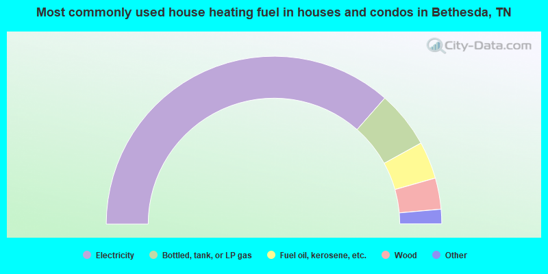
- 72.9%Electricity
- 11.0%Bottled, tank, or LP gas
- 7.2%Fuel oil, kerosene, etc.
- 6.0%Wood
- 2.4%Utility gas
- 0.4%No fuel used
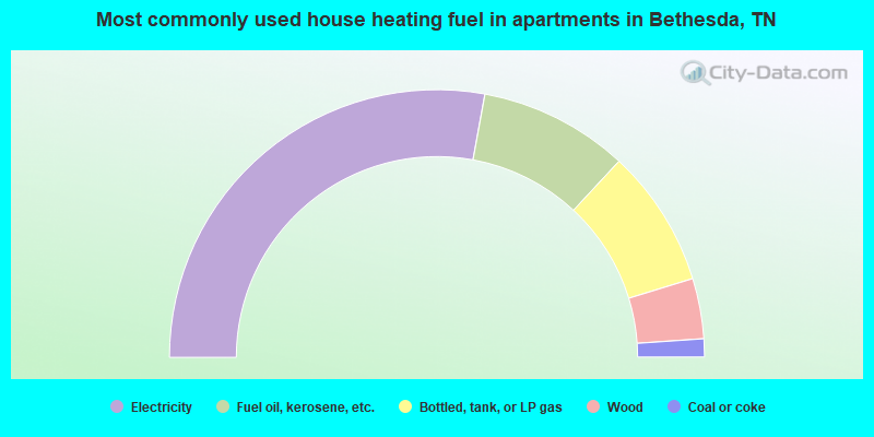
- 55.8%Electricity
- 18.1%Fuel oil, kerosene, etc.
- 16.7%Bottled, tank, or LP gas
- 7.3%Wood
- 2.2%Coal or coke
Bethesda compared to Tennessee state average:
- Unemployed percentage significantly below state average.
- Black race population percentage significantly below state average.
- Hispanic race population percentage significantly below state average.
- Foreign-born population percentage significantly below state average.
- Renting percentage significantly below state average.
- Length of stay since moving in significantly above state average.
- Number of rooms per house significantly below state average.
- House age significantly below state average.
- Percentage of population with a bachelor's degree or higher below state average.
Bethesda on our top lists:
- #3 on the list of "Top 101 cities with largest percentage of females in occupations: carpenters (population 5,000+)"
- #8 on the list of "Top 101 cities with largest percentage of females in industries: health care (population 5,000+)"
- #9 on the list of "Top 101 cities with largest percentage of males in occupations: other construction workers and helpers (population 5,000+)"
- #13 on the list of "Top 101 cities with largest percentage of females in industries: building material and garden equipment and supplies dealers (population 5,000+)"
- #16 on the list of "Top 101 cities with largest percentage of males in occupations: retail sales workers except cashiers (population 5,000+)"
- #17 on the list of "Top 101 cities with largest percentage of females in occupations: electrical equipment mechanics and other installation, maintenance, and repair occupations including supervisors (population 5,000+)"
- #22 on the list of "Top 101 cities with largest percentage of males in occupations: architects, surveyors, and cartographers (population 5,000+)"
- #22 on the list of "Top 101 cities with largest percentage of males in industries: department and other general merchandise stores (population 5,000+)"
- #25 on the list of "Top 101 cities with largest percentage of females in industries: electrical equipment, appliances, and components (population 5,000+)"
- #26 on the list of "Top 101 cities with largest percentage of males in occupations: electricians (population 5,000+)"
- #26 on the list of "Top 101 cities with largest percentage of males in industries: chemicals (population 5,000+)"
- #27 on the list of "Top 101 cities with largest percentage of females in industries: nonmetallic mineral products (population 5,000+)"
- #32 on the list of "Top 100 least racially diverse cities (pop. 5,000+)"
- #34 on the list of "Top 101 cities with largest percentage of females in industries: farm supplies merchant wholesalers (population 5,000+)"
- #47 on the list of "Top 101 cities with largest percentage of males in industries: electrical equipment, appliances, and components (population 5,000+)"
- #54 on the list of "Top 101 cities with largest percentage of males in industries: furniture and home furnishings, and household appliance stores (population 5,000+)"
- #67 on the list of "Top 101 cities with largest percentage of females in industries: textile mills and textile products (population 5,000+)"
- #73 on the list of "Top 101 cities with largest percentage of females in industries: drugs, sundries, and chemical and allied products merchant wholesalers (population 5,000+)"
- #78 on the list of "Top 101 cities with largest percentage of males in industries: other direct selling establishments (population 5,000+)"
- #82 on the list of "Top 101 cities with largest percentage of males in industries: textile mills and textile products (population 5,000+)"
- #79 on the list of "Top 101 counties with the smallest number of children under 18 without health insurance coverage in 2000 (pop. 50,000+)"