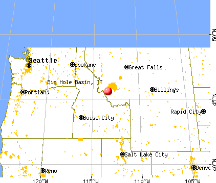
Big Hole Basin, Montana
Submit your own pictures of this place and show them to the world
- OSM Map
- General Map
- Google Map
- MSN Map

| Males: 356 | |
| Females: 311 |
| Median resident age: | 44.9 years |
| Montana median age: | 37.5 years |
Zip code: 59746
| Big Hole Basin: | $50,503 |
| MT: | $67,631 |
Estimated per capita income in 2022: $38,469 (it was $17,125 in 2000)
Big Hole Basin CCD income, earnings, and wages data
Estimated median house or condo value in 2022: $393,082 (it was $101,700 in 2000)
| Big Hole Basin: | $393,082 |
| MT: | $366,400 |
Big Hole Basin, MT residents, houses, and apartments details
Detailed information about poverty and poor residents in Big Hole Basin, MT
Compare current foreclosures near your location:
| Photo | Address | Area | Beds / Baths | Price | Details |
|---|---|---|---|---|---|

|
#1
N Rhodes St
Pretty Prairie, KS 67570
|
1,725 sq. feet
|
2 baths 4 beds |
show details | |

|
#2
S Goddard Rd
Goddard, KS 67052
|
1,054 sq. feet
|
2 baths 2 beds |
show details | |

|
#3
W 21st St N
Cheney, KS 67025
|
3,190 sq. feet
|
3 baths 5 beds |
show details | |

|
#4
E Winterset St
Goddard, KS 67052
|
816 sq. feet
|
1 baths 2 beds |
show details | |

|
#5
NE Waterloo Ave
Murdock, KS 67111
|
1,220 sq. feet
|
1 baths 3 beds |
show details | |

|
#6
W 39th St S
Goddard, KS 67052
|
4,221 sq. feet
|
3 baths 3 beds |
show details | |

|
#7
N Rhodes St
Pretty Prairie, KS 67570
|
1,725 sq. feet
|
2 baths 4 beds |
show details | |

|
#8
E Arlington Rd
Haven, KS 67543
|
960 sq. feet
|
1 baths 2 beds |
show details | |

|
#9
S 391st St W
Cheney, KS 67025
|
2,558 sq. feet
|
3 baths 3 beds |
show details | |

|
#10
SE Viney Ave
Murdock, KS 67111
|
- sq. feet
|
- baths - beds |
show details |
| Photo | Address | Area | Beds / Baths | Price | Details |
|---|---|---|---|---|---|

|
#11
W 47th St S
Garden Plain, KS 67050
|
- sq. feet
|
- baths - beds |
show details | |

|
#12
N 189th Cir W
Colwich, KS 67030
|
- sq. feet
|
- baths - beds |
show details | |

|
#13
N Main St
Goddard, KS 67052
|
- sq. feet
|
- baths - beds |
show details | |

|
#14
Martens Ct
Goddard, KS 67052
|
- sq. feet
|
- baths - beds |
show details | |

|
#15
E 4th Ave Apt 1
Cheney, KS 67025
|
- sq. feet
|
- baths - beds |
show details | |

|
#16
W Maple St Lot D
Goddard, KS 67052
|
- sq. feet
|
- baths - beds |
show details | |

|
#17
W Main St
Mount Hope, KS 67108
|
- sq. feet
|
- baths - beds |
show details | |

|
#18
S 339th St W
Cheney, KS 67025
|
- sq. feet
|
- baths - beds |
show details | |

|
#19
E Casey Dr
Goddard, KS 67052
|
- sq. feet
|
- baths - beds |
show details | |

|
Check over 1 million property listings on Foreclosure.com!
|
browse all offers | |||

- 64493.1%White alone
- 355.1%Hispanic
- 71.0%American Indian alone
- 40.6%Two or more races
- 20.3%Asian alone

Races in Big Hole Basin detailed stats: ancestries, foreign born residents, place of birth
 Recent articles from our blog. Our writers, many of them Ph.D. graduates or candidates, create easy-to-read articles on a wide variety of topics.

Current Local Time: MST time zone
Land area: 1657.5 square miles.
Population density: 0.4 people per square mile (very low).
| Big Hole Basin CCD: | 0.6% ($594) |
| Montana: | 1.3% ($1,212) |
Nearest city with pop. 50,000+: Missoula, MT  (92.2 miles , pop. 57,053).
Nearest city with pop. 200,000+: East Seattle, WA (439.8 miles , pop. 480,100).
Nearest city with pop. 1,000,000+: Phoenix, AZ (838.0 miles , pop. 1,321,045).
Nearest cities:
), ), Latitude: 45.60 N, Longitude: 113.38 W
Area code commonly used in this area: 406


| Here: | 3.2% |
| Montana: | 3.8% |

- Agriculture, forestry, fishing & hunting (44.5%)
- Accommodation & food services (10.2%)
- Construction (6.6%)
- Educational services (5.8%)
- Health care (5.2%)
- Public administration (4.1%)
- Broadcasting & telecommunications (3.6%)

- Agriculture, forestry, fishing & hunting (53.7%)
- Construction (10.6%)
- Accommodation & food services (8.4%)
- Health care (5.3%)
- Broadcasting & telecommunications (3.5%)
- Public administration (3.1%)
- Repair & maintenance (2.2%)

- Agriculture, forestry, fishing & hunting (29.2%)
- Educational services (15.3%)
- Accommodation & food services (13.1%)
- Public administration (5.8%)
- Health care (5.1%)
- Administrative & support & waste management services (4.4%)
- Food & beverage stores (3.6%)

- Farmers and farm managers (20.6%)
- Agricultural workers, including supervisors (15.1%)
- Other management occupations, except farmers and farm managers (4.7%)
- Building and grounds cleaning and maintenance occupations (4.1%)
- Other office and administrative support workers, including supervisors (3.6%)
- Supervisors and other personal care and service workers, except child care workers (3.3%)
- Life and physical scientists (3.0%)

- Farmers and farm managers (23.3%)
- Agricultural workers, including supervisors (20.3%)
- Supervisors and other personal care and service workers, except child care workers (5.3%)
- Vehicle and mobile equipment mechanics, installers, and repairers (4.8%)
- Other food preparation and serving workers, including supervisors (4.0%)
- Supervisors, construction and extraction workers (3.5%)
- Other management occupations, except farmers and farm managers (3.1%)

- Farmers and farm managers (16.1%)
- Building and grounds cleaning and maintenance occupations (8.0%)
- Cooks and food preparation workers (7.3%)
- Other management occupations, except farmers and farm managers (7.3%)
- Agricultural workers, including supervisors (6.6%)
- Other office and administrative support workers, including supervisors (6.6%)
- Preschool, kindergarten, elementary, and middle school teachers (5.8%)
Average climate in Big Hole Basin, Montana
Based on data reported by over 4,000 weather stations


Earthquake activity:
Big Hole Basin-area historical earthquake activity is significantly above Montana state average. It is 1075% greater than the overall U.S. average.On 8/18/1959 at 06:37:13, a magnitude 7.7 (7.7 UK, Class: Major, Intensity: VIII - XII) earthquake occurred 151.1 miles away from the city center, causing $26,000,000 total damage
On 10/28/1983 at 14:06:06, a magnitude 7.3 (6.2 MB, 7.3 MS, 7.0 MW) earthquake occurred 107.5 miles away from Big Hole Basin center, causing 2 deaths (2 shaking deaths) and 3 injuries, causing $15,000,000 total damage
On 3/31/2020 at 23:52:30, a magnitude 6.5 (6.5 MW, Depth: 7.5 mi, Class: Strong, Intensity: VII - IX) earthquake occurred 115.8 miles away from Big Hole Basin center
On 10/3/1915 at 06:52:48, a magnitude 7.6 (7.6 UK) earthquake occurred 409.6 miles away from Big Hole Basin center
On 7/26/2005 at 04:08:37, a magnitude 5.7 (5.7 MB, 5.2 MS, 5.6 MW, Class: Moderate, Intensity: VI - VII) earthquake occurred 41.6 miles away from Big Hole Basin center
On 6/30/1975 at 18:54:13, a magnitude 6.1 (5.6 MB, 5.9 MS, 6.1 UK, 6.1 ML) earthquake occurred 144.1 miles away from Big Hole Basin center
Magnitude types: body-wave magnitude (MB), local magnitude (ML), surface-wave magnitude (MS), moment magnitude (MW)
Natural disasters:
The number of natural disasters in Beaverhead County (4) is a lot smaller than the US average (15).Major Disasters (Presidential) Declared: 1
Emergencies Declared: 1
Causes of natural disasters: Fires: 2, Hurricane: 1, Other: 1 (Note: some incidents may be assigned to more than one category).
Colleges/universities with over 2000 students nearest to Big Hole Basin:
- The University of Montana (about 92 miles; Missoula, MT; Full-time enrollment: 13,602)
- Montana State University (about 113 miles; Bozeman, MT; FT enrollment: 12,942)
- Brigham Young University-Idaho (about 147 miles; Rexburg, ID; FT enrollment: 30,522)
- Lewis-Clark State College (about 184 miles; Lewiston, ID; FT enrollment: 3,199)
- University of Idaho (about 192 miles; Moscow, ID; FT enrollment: 10,416)
- Idaho State University (about 196 miles; Pocatello, ID; FT enrollment: 10,350)
- Boise State University (about 197 miles; Boise, ID; FT enrollment: 16,774)
Points of interest:
Notable locations in Big Hole Basin: Little Joe Campground (A), Lodgepole Campground (B), Fred Else (C), Dickie Bridge Campground (D), Foolhen Forest Service Statin (E), O Heggelund (F), Parsons Ranch (G), M Heggelund (H), May Creek Campground (I), McVey Homestead (J), Mono Creek Campground (K), Mussigbrod Homestead (L), One Thousand One Hundred Twenty Ranch (M), Ore Mill (N), Anderson Meadows Cow Camp (O), Alice Cabin (P), Ajax Ranch (Q), Rutledge Ranch (R), Siria Ranch (S), Spokane Ranch (T). Display/hide their locations on the map
Churches in Big Hole Basin include: Church of the Big Hole (A), Our Lady of Wisdom Mission (B). Display/hide their locations on the map
Cemeteries: Briston Cemetery (1), Dewey Cemetery (2), Popularis Cemetery (3), Wisdom Cemetery (4), Maurice Cemetery (5). Display/hide their locations on the map
Lakes, reservoirs, and swamps: Highup Lake (A), Ridge Lake (B), Black Lion Lake (C), Hopkin Lake (D), Phlox Lake (E), Maurice Pond (F), Alpine Lake (G), Ice Pond (H). Display/hide their locations on the map
Rivers and creeks: Hunter Creek (A), Addition Creek (B), Adson Creek (C), Alder Creek (D), Anderson Creek (E), Andrus Creek (F), Armor Creek (G), Bailey Creek (H), Bear Creek (I). Display/hide their locations on the map
Parks in Big Hole Basin include: Big Hole National Battlefield (1), Gravelle Park (2), Dutch Park (3), Happy Camp Park (4), American Legion Park (5). Display/hide their locations on the map
| This place: | 2.0 people |
| Montana: | 2.4 people |
| This place: | 58.3% |
| Whole state: | 62.8% |
| This place: | 4.7% |
| Whole state: | 6.7% |
Likely homosexual households (counted as self-reported same-sex unmarried-partner households)
- Lesbian couples: 0.7% of all households
- Gay men: 0.3% of all households
| This place: | 12.8% |
| Whole state: | 14.6% |
| This place: | 5.9% |
| Whole state: | 5.8% |
4 people in agriculture workers' dormitories on farms in 2000
For population 15 years and over in Big Hole Basin:

- Never married: 13.3%
- Now married: 69.1%
- Separated: 0.4%
- Widowed: 6.0%
- Divorced: 11.7%
For population 25 years and over in Big Hole Basin:
- High school or higher: 92.8%
- Bachelor's degree or higher: 20.0%
- Graduate or professional degree: 3.8%
- Unemployed: 4.2%
- Mean travel time to work (commute): 17.6 minutes


| Here: | 8.8 |
| Montana average: | 10.4 |
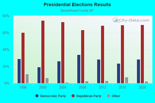
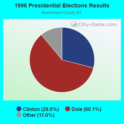
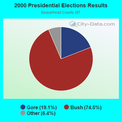
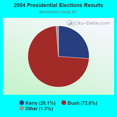
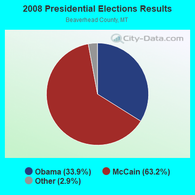


Graphs represent county-level data. Detailed 2008 Election Results
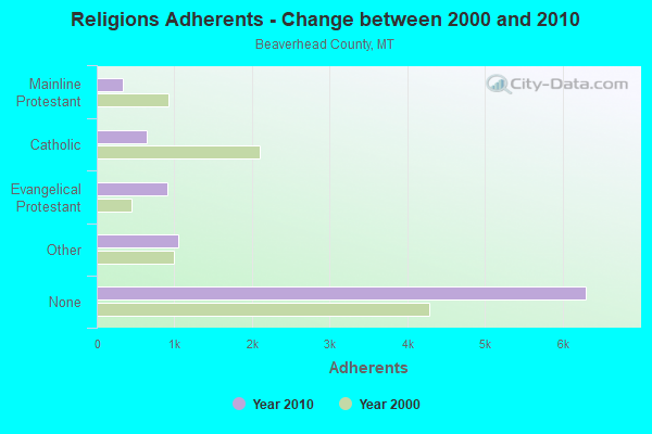
Religion statistics for Big Hole Basin, MT (based on Beaverhead County data)
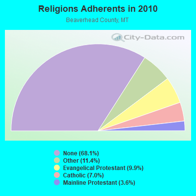
| Religion | Adherents | Congregations |
|---|---|---|
| Other | 1,052 | 5 |
| Evangelical Protestant | 911 | 10 |
| Catholic | 650 | 3 |
| Mainline Protestant | 332 | 5 |
| None | 6,301 | - |
Food Environment Statistics:
| Here: | 3.41 / 10,000 pop. |
| Montana: | 2.55 / 10,000 pop. |
| This county: | 5.68 / 10,000 pop. |
| State: | 4.69 / 10,000 pop. |
| Beaverhead County: | 18.17 / 10,000 pop. |
| Montana: | 10.38 / 10,000 pop. |
| Beaverhead County: | 8.4% |
| Montana: | 7.2% |
| Beaverhead County: | 23.0% |
| Montana: | 23.1% |
| This county: | 7.6% |
| Montana: | 10.7% |
Strongest AM radio stations in Big Hole Basin:
- KBOW (550 AM; 5 kW; BUTTE, MT; Owner: BUTTE BROADCASTING INCORPORATED)
- KERR (750 AM; 50 kW; POLSON, MT; Owner: ANDERSON RADIO BROADCASTING, INC.)
- KXTL (1370 AM; 5 kW; BUTTE, MT; Owner: FISHER RADIO REGIONAL GROUP, INC.)
- KBOI (670 AM; 50 kW; BOISE, ID; Owner: CITADEL BROADCASTING COMPANY)
- KGVW (640 AM; 10 kW; BELGRADE, MT; Owner: GALLATIN VALLEY WITNESS, INC.)
- KOFI (1180 AM; 50 kW; KALISPELL, MT; Owner: KOFI, INC.)
- KWEI (1260 AM; 50 kW; WEISER, ID; Owner: TREASURE VALLEY BROADCASTING CO.)
- KANA (580 AM; 1 kW; ANACONDA, MT; Owner: JIMMY RAY CARROLL)
- KKGR (680 AM; daytime; 5 kW; EAST HELENA, MT; Owner: KKGR, INC.)
- KSRA (960 AM; 1 kW; SALMON, ID; Owner: SALMON RIVER COMMUNICATIONS, INC.)
- KGA (1510 AM; 50 kW; SPOKANE, WA; Owner: CITADEL BROADCASTING COMPANY)
- KALL (700 AM; 50 kW; NORTH SALT LAKE CITY, UT; Owner: CITICASTERS LICENSES, L.P.)
- KTBI (810 AM; daytime; 50 kW; EPHRATA, WA; Owner: TACOMA BROADCASTERS, INCORPORATED)
Strongest FM radio stations in Big Hole Basin:
- K210BF (89.9 FM; BUTTE, MT; Owner: FAMILY STATIONS, INC.)
- KAPC (91.3 FM; BUTTE, MT; Owner: THE UNIVERSITY OF MONTANA)
- KOPR (94.1 FM; BUTTE, MT; Owner: BUTTE BROADCASTING INCORPORATED)
- KMBR (95.5 FM; BUTTE, MT; Owner: FISHER RADIO REGIONAL GROUP, INC.)
- K213CJ (90.5 FM; BUTTE, MT; Owner: MONTANA CHRISTIAN RADIO ASSOCIATION)
- KAAR (92.5 FM; BUTTE, MT; Owner: FISHER RADIO REGIONAL GROUP, INC.)
- KBAZ (96.3 FM; HAMILTON, MT; Owner: CAPSTAR TX LIMITED PARTNERSHIP)
- KQRV (96.9 FM; DEER LODGE, MT; Owner: ROBERT CUMMINGS TOOLE)
- KGLM-FM (97.7 FM; ANACONDA, MT; Owner: JIMMY RAY CARROLL)

- 39.8%Bottled, tank, or LP gas
- 31.8%Wood
- 12.9%Electricity
- 8.0%Fuel oil, kerosene, etc.
- 6.5%Other fuel
- 1.0%No fuel used

- 34.3%Wood
- 33.3%Bottled, tank, or LP gas
- 27.8%Electricity
- 4.6%Fuel oil, kerosene, etc.
Big Hole Basin compared to Montana state average:
- Unemployed percentage significantly below state average.
- Black race population percentage significantly below state average.
- Median age above state average.
- Foreign-born population percentage significantly below state average.
- Length of stay since moving in significantly above state average.
- Number of rooms per house significantly below state average.
- House age significantly below state average.
- Number of college students significantly below state average.
Big Hole Basin on our top lists:
- #71 on the list of "Top 100 cities with largest land areas"
State forum archive: