Bloomfield, New Mexico
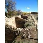
Bloomfield: Salmon Ruins Row Of Rooms
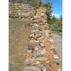
Bloomfield: Salmon Ruins Wall Up Close
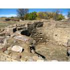
Bloomfield: Salmon Ruins Kiva
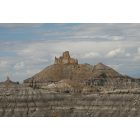
Bloomfield: Angel Peak
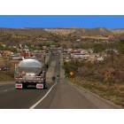
Bloomfield: Bloomfield
- add
your


Submit your own pictures of this city and show them to the world
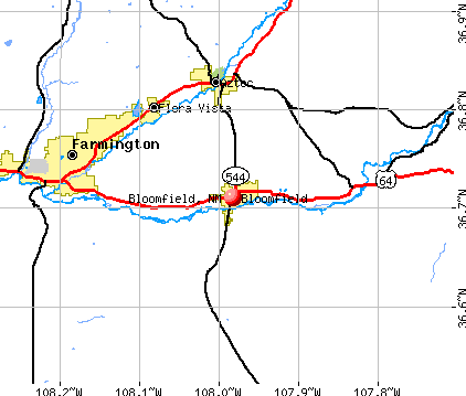
- OSM Map
- General Map
- Google Map
- MSN Map
Population change since 2000: +14.3%
| Males: 3,676 | |
| Females: 3,659 |
| Median resident age: | 33.8 years |
| New Mexico median age: | 39.4 years |
Zip codes: 87413.
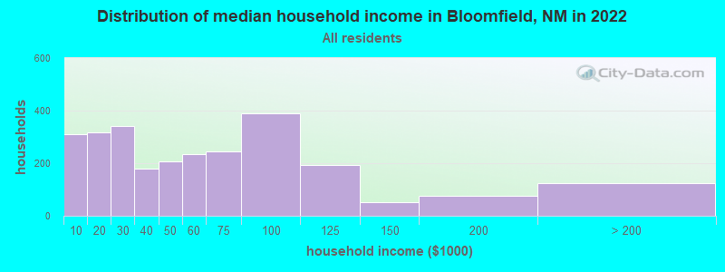
| Bloomfield: | $48,984 |
| NM: | $59,726 |
Estimated per capita income in 2022: $23,651 (it was $14,424 in 2000)
Bloomfield city income, earnings, and wages data
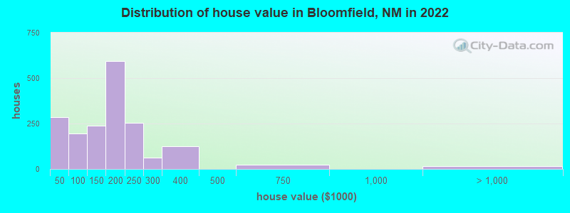
Estimated median house or condo value in 2022: $172,537 (it was $71,400 in 2000)
| Bloomfield: | $172,537 |
| NM: | $243,100 |
Mean prices in 2022: all housing units: $225,451; detached houses: $261,783; townhouses or other attached units: $199,577; mobile homes: $189,727
Median gross rent in 2022: $814.
(18.9% for White Non-Hispanic residents, 17.2% for Hispanic or Latino residents, 36.4% for American Indian residents, 17.4% for other race residents, 13.1% for two or more races residents)
Detailed information about poverty and poor residents in Bloomfield, NM

Compare current foreclosures near Bloomfield, NM:
| Photo | Address | Area | Beds / Baths | Price | Details |
|---|---|---|---|---|---|

|
#1
Road 51921 # A
Bloomfield, NM 87413
|
2,414 sq. feet
|
2 baths 4 beds |
show details | |

|
#2
Road 47251
Bloomfield, NM 87413
|
- sq. feet
|
2 baths 4 beds |
show details | |

|
#3
Calle Del Rio
Bloomfield, NM 87413
|
1,646 sq. feet
|
2 baths 3 beds |
show details | |

|
#4
W Blanco Blvd
Bloomfield, NM 87413
|
- sq. feet
|
2 baths 3 beds |
show details | |

|
#5
N Moore St
Bloomfield, NM 87413
|
- sq. feet
|
2 baths 3 beds |
show details | |

|
#6
Road 5076
Bloomfield, NM 87413
|
1,461 sq. feet
|
2 baths 3 beds |
show details | |

|
#7
Road 4990
Bloomfield, NM 87413
|
- sq. feet
|
- baths - beds |
show details | |

|
#8
Road 5063
Bloomfield, NM 87413
|
- sq. feet
|
- baths - beds |
show details | |

|
#9
Road 499 A
Bloomfield, NM 87413
|
- sq. feet
|
- baths - beds |
show details | |

|
#10
Us 64
Bloomfield, NM 87413
|
- sq. feet
|
- baths - beds |
show details |
| Photo | Address | Area | Beds / Baths | Price | Details |
|---|---|---|---|---|---|

|
#11
Katherine Ave
Farmington, NM 87401
|
1,396 sq. feet
|
2 baths 3 beds |
$295,000
|
show details |

|
#12
N Church St
Bloomfield, NM 87413
|
- sq. feet
|
- baths - beds |
show details | |

|
#13
Road 5023
Bloomfield, NM 87413
|
- sq. feet
|
- baths - beds |
show details | |

|
#14
E Pine Ave
Bloomfield, NM 87413
|
- sq. feet
|
- baths - beds |
show details | |

|
#15
Road 47255
Bloomfield, NM 87413
|
- sq. feet
|
- baths - beds |
show details | |

|
#16
Kayenta Cir
Farmington, NM 87402
|
- sq. feet
|
1 baths 3 beds |
show details | |

|
#17
Ostrich St
Farmington, NM 87401
|
- sq. feet
|
- baths - beds |
show details | |

|
#18
Chilton Ct
Farmington, NM 87401
|
- sq. feet
|
- baths - beds |
show details | |

|
#19
El Paso Dr
Farmington, NM 87401
|
- sq. feet
|
- baths - beds |
show details | |

|
#20
W 24th St
Farmington, NM 87401
|
- sq. feet
|
- baths - beds |
show details |
| Photo | Address | Area | Beds / Baths | Price | Details |
|---|---|---|---|---|---|

|
#21
E Main St, Ste 106 Pmb 158
Farmington, NM 87402
|
- sq. feet
|
- baths - beds |
show details | |

|
#22
Precept Way
Farmington, NM 87402
|
- sq. feet
|
- baths - beds |
show details | |

|
#23
Kiva Ave
Aztec, NM 87410
|
- sq. feet
|
- baths - beds |
show details | |

|
#24
Villa View Dr Apt 14b
Farmington, NM 87402
|
- sq. feet
|
- baths - beds |
show details | |

|
#25
Road 2597
Aztec, NM 87410
|
- sq. feet
|
- baths - beds |
show details | |

|
#26
Mountain View Dr
Aztec, NM 87410
|
- sq. feet
|
- baths - beds |
show details | |

|
#27
Road 5295
Farmington, NM 87401
|
- sq. feet
|
- baths - beds |
show details | |

|
#28
Road 5466
Farmington, NM 87401
|
- sq. feet
|
- baths - beds |
show details | |

|
#29
Road 3320
Aztec, NM 87410
|
- sq. feet
|
- baths - beds |
show details | |

|
#30
Us 64
Blanco, NM 87412
|
- sq. feet
|
- baths - beds |
show details |
| Photo | Address | Area | Beds / Baths | Price | Details |
|---|---|---|---|---|---|

|
#31
N Chaco Ave
Farmington, NM 87401
|
- sq. feet
|
- baths - beds |
show details | |

|
#32
Maricopa Pl
Farmington, NM 87401
|
- sq. feet
|
- baths - beds |
show details | |

|
#33
N Mesa Verde Ave
Farmington, NM 87401
|
- sq. feet
|
- baths - beds |
show details | |

|
#34
State Highway 511
Blanco, NM 87412
|
- sq. feet
|
- baths - beds |
show details | |

|
#35
N Monterey Ave
Farmington, NM 87401
|
- sq. feet
|
- baths - beds |
show details | |

|
#36
Road 2900
Aztec, NM 87410
|
- sq. feet
|
- baths - beds |
show details | |

|
#37
Crestridge Dr
Farmington, NM 87401
|
- sq. feet
|
- baths - beds |
show details | |

|
#38
Crestridge Dr
Farmington, NM 87401
|
- sq. feet
|
- baths - beds |
show details | |

|
#39
W 35th St
Farmington, NM 87401
|
- sq. feet
|
- baths - beds |
show details | |

|
#40
Road 3490
Flora Vista, NM 87415
|
- sq. feet
|
- baths - beds |
show details |
| Photo | Address | Area | Beds / Baths | Price | Details |
|---|---|---|---|---|---|

|
#41
E 15th St
Farmington, NM 87401
|
- sq. feet
|
- baths - beds |
show details | |

|
#42
Lynwood Dr
Farmington, NM 87401
|
- sq. feet
|
- baths - beds |
show details | |

|
#43
N Western Ave
Farmington, NM 87401
|
- sq. feet
|
- baths - beds |
show details | |

|
#44
Road 5587
Farmington, NM 87401
|
- sq. feet
|
- baths - beds |
show details | |

|
#45
W 31st St
Farmington, NM 87401
|
- sq. feet
|
- baths - beds |
show details | |

|
#46
Ocio St
Farmington, NM 87401
|
- sq. feet
|
- baths - beds |
show details | |

|
#47
W Lonewolf Dr
Farmington, NM 87401
|
- sq. feet
|
- baths - beds |
show details | |

|
#48
La Sierra Pl
Farmington, NM 87401
|
- sq. feet
|
- baths - beds |
show details | |

|
#49
Road 1790
Farmington, NM 87401
|
- sq. feet
|
- baths - beds |
show details | |

|
Check over 1 million property listings on Foreclosure.com!
|
browse all offers | |||


- 3,08041.9%White alone
- 2,25630.7%Hispanic
- 1,62622.1%American Indian alone
- 3364.6%Two or more races
- 260.4%Black alone
- 280.4%Other race alone
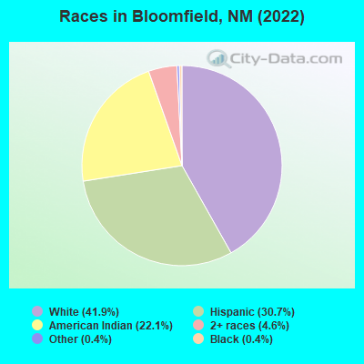
Races in Bloomfield detailed stats: ancestries, foreign born residents, place of birth
According to our research of New Mexico and other state lists, there were 26 registered sex offenders living in Bloomfield, New Mexico as of April 19, 2024.
The ratio of all residents to sex offenders in Bloomfield is 273 to 1.
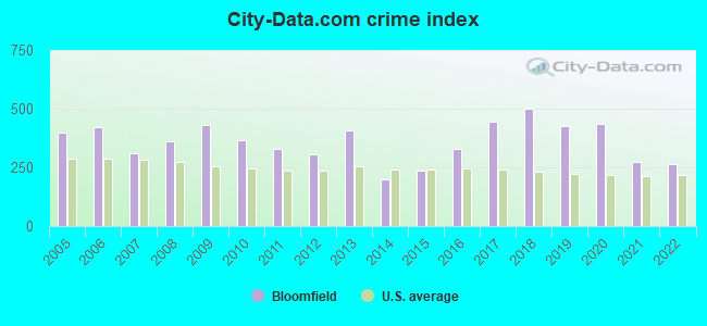
Type |
2009 |
2010 |
2011 |
2012 |
2013 |
2014 |
2015 |
2016 |
2017 |
2018 |
2019 |
2020 |
2021 |
2022 |
|---|---|---|---|---|---|---|---|---|---|---|---|---|---|---|
| Murders (per 100,000) | 0 (0.0) | 0 (0.0) | 1 (12.2) | 0 (0.0) | 1 (12.6) | 0 (0.0) | 0 (0.0) | 0 (0.0) | 0 (0.0) | 1 (12.6) | 0 (0.0) | 1 (13.1) | 0 (0.0) | 1 (13.6) |
| Rapes (per 100,000) | 11 (150.9) | 7 (86.3) | 5 (61.0) | 11 (137.3) | 17 (214.7) | 4 (51.8) | 3 (39.9) | 10 (139.6) | 8 (115.4) | 11 (138.9) | 6 (76.9) | 16 (209.6) | 10 (131.7) | 7 (95.4) |
| Robberies (per 100,000) | 4 (54.9) | 1 (12.3) | 2 (24.4) | 1 (12.5) | 0 (0.0) | 0 (0.0) | 5 (66.5) | 2 (27.9) | 1 (14.4) | 1 (12.6) | 3 (38.5) | 6 (78.6) | 5 (65.9) | 1 (13.6) |
| Assaults (per 100,000) | 52 (713.1) | 78 (961.5) | 66 (804.6) | 42 (524.3) | 46 (581.0) | 25 (323.7) | 28 (372.2) | 28 (390.9) | 80 (1,154) | 114 (1,439) | 110 (1,410) | 55 (720.6) | 29 (381.9) | 29 (395.4) |
| Burglaries (per 100,000) | 46 (630.8) | 38 (468.4) | 41 (499.8) | 27 (337.0) | 34 (429.4) | 37 (479.0) | 38 (505.2) | 53 (739.9) | 36 (519.3) | 36 (454.4) | 30 (384.7) | 21 (275.1) | 23 (302.9) | 26 (354.5) |
| Thefts (per 100,000) | 167 (2,290) | 117 (1,442) | 107 (1,304) | 124 (1,548) | 116 (1,465) | 106 (1,372) | 107 (1,422) | 119 (1,661) | 127 (1,832) | 64 (807.9) | 67 (859.1) | 91 (1,192) | 72 (948.2) | 80 (1,091) |
| Auto thefts (per 100,000) | 15 (205.7) | 11 (135.6) | 0 (0.0) | 3 (37.4) | 6 (75.8) | 3 (38.8) | 15 (199.4) | 13 (181.5) | 9 (129.8) | 9 (113.6) | 8 (102.6) | 9 (117.9) | 12 (158.0) | 9 (122.7) |
| Arson (per 100,000) | 0 (0.0) | 4 (49.3) | 1 (12.2) | 3 (37.4) | 0 (0.0) | 0 (0.0) | 1 (13.3) | 0 (0.0) | 0 (0.0) | 2 (25.2) | 0 (0.0) | 1 (13.1) | 1 (13.2) | 1 (13.6) |
| City-Data.com crime index | 432.0 | 366.4 | 328.5 | 307.0 | 407.9 | 197.7 | 234.5 | 331.0 | 447.5 | 501.1 | 424.7 | 438.0 | 273.3 | 265.0 |
The City-Data.com crime index weighs serious crimes and violent crimes more heavily. Higher means more crime, U.S. average is 246.1. It adjusts for the number of visitors and daily workers commuting into cities.
Crime rate in Bloomfield detailed stats: murders, rapes, robberies, assaults, burglaries, thefts, arson
Full-time law enforcement employees in 2018, including police officers: 14 (12 officers - 12 male; 0 female).
| Officers per 1,000 residents here: | 1.51 |
| New Mexico average: | 2.73 |
 Recent articles from our blog. Our writers, many of them Ph.D. graduates or candidates, create easy-to-read articles on a wide variety of topics.


 | unique NM towns to potentially settle (35 replies) |
| Farmington as a retirement destination (10 replies) |
| What's your favorite book, fiction or non-fiction, set in ABQ or NM? (44 replies) |
| Dome Homes- are there communities? (4 replies) |
| Rte 550 from Bernalillo to Farmington (8 replies) |
| New Mexico’s 20 Safest Cities of 2018 (13 replies) |
Latest news from Bloomfield, NM collected exclusively by city-data.com from local newspapers, TV, and radio stations
Ancestries: German (13.8%), American (4.8%), Swedish (2.4%), English (2.3%), Irish (1.6%), Scandinavian (1.1%).
Current Local Time: MST time zone
Elevation: 5453 feet
Land area: 5.01 square miles.
Population density: 1,464 people per square mile (low).
147 residents are foreign born (1.9% Latin America).
| This city: | 2.0% |
| New Mexico: | 9.2% |
Median real estate property taxes paid for housing units with mortgages in 2022: $1,331 (0.7%)
Median real estate property taxes paid for housing units with no mortgage in 2022: $956 (0.7%)
Nearest city with pop. 50,000+: Rio Rancho, NM  (122.9 miles , pop. 51,765).
Nearest city with pop. 200,000+: Albuquerque, NM (134.8 miles , pop. 448,607).
Nearest city with pop. 1,000,000+: Phoenix, AZ (319.4 miles , pop. 1,321,045).
Nearest cities:
), ), ), ), ), Latitude: 36.71 N, Longitude: 107.98 W
Area code commonly used in this area: 505

Bloomfield tourist attractions:
Bloomfield, New Mexico accommodation & food services, waste management - Economy and Business Data
| Here: | 3.9% |
| New Mexico: | 3.6% |
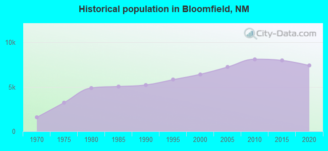
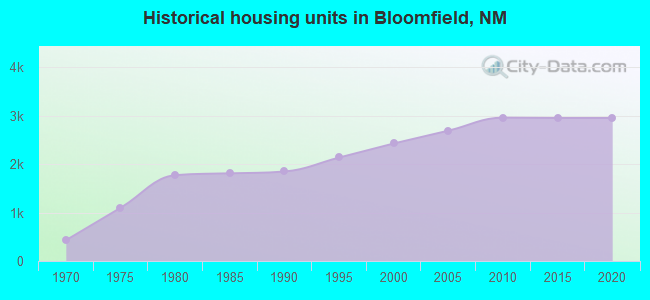
Population change in the 1990s: +1,056 (+19.7%).
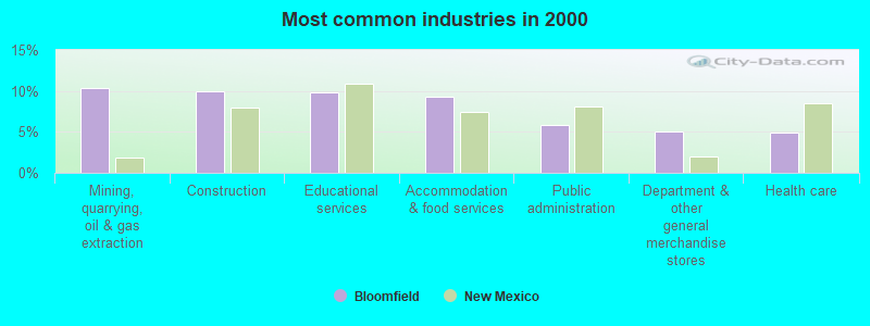
- Mining, quarrying, oil & gas extraction (10.3%)
- Construction (9.9%)
- Educational services (9.8%)
- Accommodation & food services (9.3%)
- Public administration (5.9%)
- Department & other general merchandise stores (5.0%)
- Health care (5.0%)
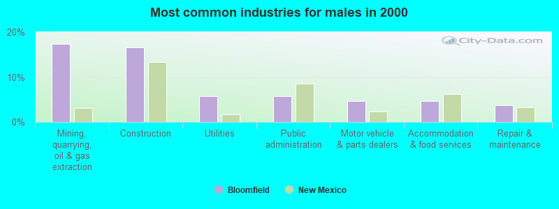
- Mining, quarrying, oil & gas extraction (17.3%)
- Construction (16.6%)
- Utilities (5.8%)
- Public administration (5.8%)
- Motor vehicle & parts dealers (4.6%)
- Accommodation & food services (4.6%)
- Repair & maintenance (3.8%)
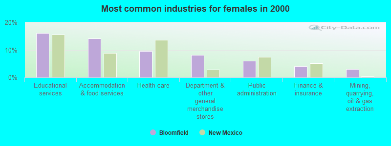
- Educational services (16.2%)
- Accommodation & food services (14.1%)
- Health care (9.6%)
- Department & other general merchandise stores (8.2%)
- Public administration (6.0%)
- Finance & insurance (4.1%)
- Mining, quarrying, oil & gas extraction (3.1%)
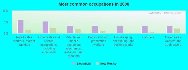
- Retail sales workers, except cashiers (5.9%)
- Other sales and related occupations, including supervisors (5.3%)
- Vehicle and mobile equipment mechanics, installers, and repairers (3.4%)
- Cooks and food preparation workers (3.4%)
- Bookkeeping, accounting, and auditing clerks (3.3%)
- Cashiers (3.3%)
- Driver/sales workers and truck drivers (3.2%)
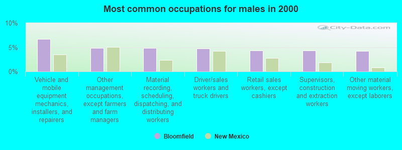
- Vehicle and mobile equipment mechanics, installers, and repairers (6.7%)
- Other management occupations, except farmers and farm managers (4.9%)
- Material recording, scheduling, dispatching, and distributing workers (4.9%)
- Driver/sales workers and truck drivers (4.7%)
- Retail sales workers, except cashiers (4.3%)
- Supervisors, construction and extraction workers (4.3%)
- Other material moving workers, except laborers (4.3%)
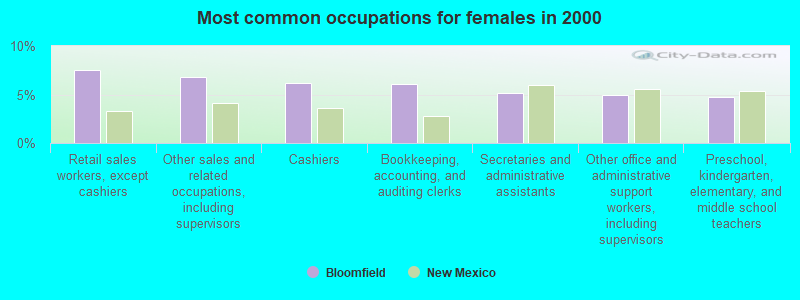
- Retail sales workers, except cashiers (7.5%)
- Other sales and related occupations, including supervisors (6.8%)
- Cashiers (6.2%)
- Bookkeeping, accounting, and auditing clerks (6.1%)
- Secretaries and administrative assistants (5.1%)
- Other office and administrative support workers, including supervisors (5.0%)
- Preschool, kindergarten, elementary, and middle school teachers (4.8%)
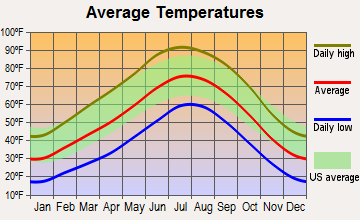
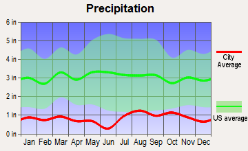
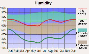
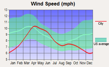
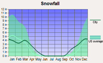
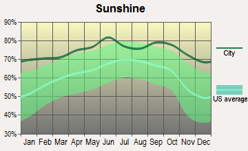
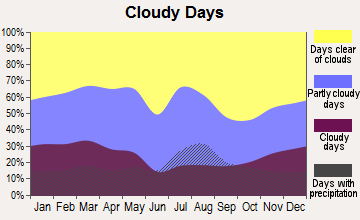
Average climate in Bloomfield, New Mexico
Based on data reported by over 4,000 weather stations
|
|

(lower is better)
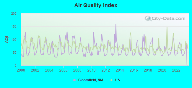
Air Quality Index (AQI) level in 2022 was 59.9. This is better than average.
| City: | 59.9 |
| U.S.: | 72.6 |
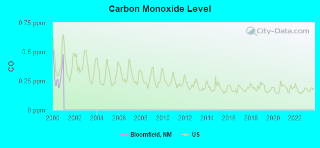
Carbon Monoxide (CO) [ppm] level in 2000 was 0.308. This is worse than average. Closest monitor was 12.1 miles away from the city center.
| City: | 0.308 |
| U.S.: | 0.251 |
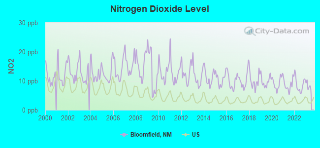
Nitrogen Dioxide (NO2) [ppb] level in 2022 was 8.68. This is significantly worse than average. Closest monitor was 2.2 miles away from the city center.
| City: | 8.68 |
| U.S.: | 5.11 |
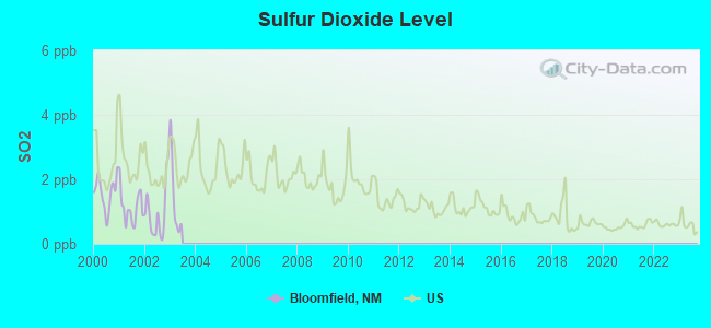
Sulfur Dioxide (SO2) [ppb] level in 2002 was 0.963. This is significantly better than average. Closest monitor was 13.1 miles away from the city center.
| City: | 0.963 |
| U.S.: | 1.515 |
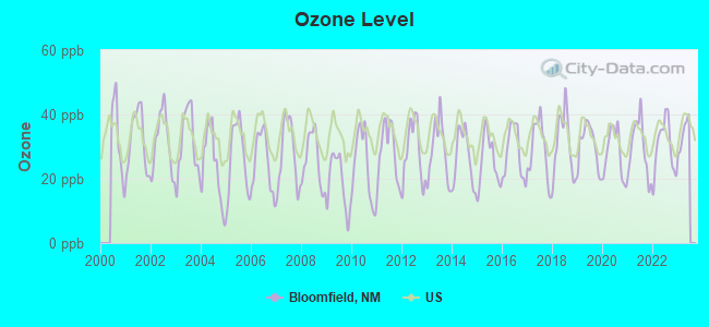
Ozone [ppb] level in 2022 was 29.9. This is about average. Closest monitor was 2.2 miles away from the city center.
| City: | 29.9 |
| U.S.: | 33.3 |
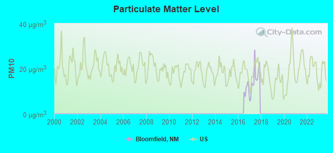
Particulate Matter (PM10) [µg/m3] level in 2017 was 15.4. This is better than average. Closest monitor was 2.2 miles away from the city center.
| City: | 15.4 |
| U.S.: | 19.2 |
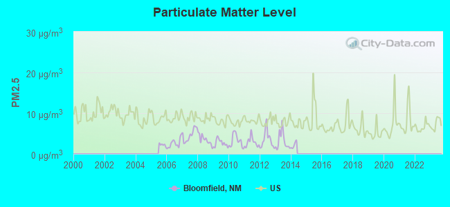
Particulate Matter (PM2.5) [µg/m3] level in 2013 was 3.14. This is significantly better than average. Closest monitor was 11.0 miles away from the city center.
| City: | 3.14 |
| U.S.: | 8.11 |
Earthquake activity:
Bloomfield-area historical earthquake activity is significantly above New Mexico state average. It is 1196% greater than the overall U.S. average.On 6/28/1992 at 11:57:34, a magnitude 7.6 (6.2 MB, 7.6 MS, 7.3 MW, Depth: 0.7 mi, Class: Major, Intensity: VIII - XII) earthquake occurred 512.2 miles away from Bloomfield center, causing 3 deaths (1 shaking deaths, 2 other deaths) and 400 injuries, causing $100,000,000 total damage and $40,000,000 insured losses
On 10/16/1999 at 09:46:44, a magnitude 7.4 (6.3 MB, 7.4 MS, 7.2 MW, 7.3 ML) earthquake occurred 498.7 miles away from Bloomfield center
On 8/18/1959 at 06:37:13, a magnitude 7.7 (7.7 UK) earthquake occurred 561.1 miles away from the city center, causing $26,000,000 total damage
On 5/19/1940 at 04:36:40, a magnitude 7.2 (7.2 UK) earthquake occurred 499.2 miles away from the city center, causing $33,000,000 total damage
On 10/3/1915 at 06:52:48, a magnitude 7.6 (7.6 UK) earthquake occurred 576.9 miles away from the city center
On 8/23/2011 at 05:46:18, a magnitude 5.3 (5.3 MW, Depth: 2.5 mi, Class: Moderate, Intensity: VI - VII) earthquake occurred 183.2 miles away from the city center
Magnitude types: body-wave magnitude (MB), local magnitude (ML), surface-wave magnitude (MS), moment magnitude (MW)
Natural disasters:
The number of natural disasters in San Juan County (9) is smaller than the US average (15).Major Disasters (Presidential) Declared: 4
Emergencies Declared: 3
Causes of natural disasters: Floods: 3, Storms: 3, Fires: 2, Drought: 1, Hurricane: 1, Mudslide: 1, Other: 2 (Note: some incidents may be assigned to more than one category).
Hospitals and medical centers in Bloomfield:
Other hospitals and medical centers near Bloomfield:
- FOUR CORNERS GOOD SAMARITAN VILLAGE (Nursing Home, about 9 miles away; AZTEC, NM)
- HORIZON HOME CARE (Home Health Center, about 13 miles away; FARMINGTON, NM)
- BASIN HOME HEALTH INC (Home Health Center, about 13 miles away; FARMINGTON, NM)
- SOUTHWESTERN HOME HEALTH CARE, INC (Home Health Center, about 13 miles away; FARMINGTON, NM)
- SAN JUAN REGIONAL REHABILITATION HOSPITAL (Hospital, about 13 miles away; FARMINGTON, NM)
- SAN JUAN REGIONAL MEDICAL CENTER Acute Care Hospitals (about 13 miles away; FARMINGTON, NM)
- SAN JUAN CARE AND REHABILITATION CENTER (Nursing Home, about 13 miles away; FARMINGTON, NM)
Colleges/universities with over 2000 students nearest to Bloomfield:
- San Juan College (about 12 miles; Farmington, NM; Full-time enrollment: 5,112)
- Fort Lewis College (about 40 miles; Durango, CO; FT enrollment: 3,631)
- Adams State University (about 128 miles; Alamosa, CO; FT enrollment: 2,805)
- University of Phoenix-Albuquerque Campus (about 131 miles; Albuquerque, NM; FT enrollment: 2,335)
- Santa Fe Community College (about 136 miles; Santa Fe, NM; FT enrollment: 3,047)
- University of New Mexico-Main Campus (about 136 miles; Albuquerque, NM; FT enrollment: 23,042)
- Central New Mexico Community College (about 137 miles; Albuquerque, NM; FT enrollment: 19,398)
Public high schools in Bloomfield:
- BLOOMFIELD HIGH (Students: 818, Location: 520 NORTH FIRST ST, Grades: 9-12)
- CHARLIE Y. BROWN ALT (Students: 96, Location: 924 SOUTH BLOOMFIELD BLVD, Grades: 9-12)
- HANAA'DLI COMMUNITY SCHOOL (Location: CTY RD 7150 STOP#700, Grades: KG-12)
Public elementary/middle schools in Bloomfield:
- CENTRAL PRIMARY (Students: 652, Location: 310 WEST SYCAMORE, Grades: 1-3)
- NAABA ANI ELEMENTARY (Students: 570, Location: 1201 NORTH FIRST ST, Grades: 4-6)
- MESA ALTA JR HIGH (Students: 455, Location: 329 NORTH BERGIN LN, Grades: 7-8)
- DZILTH-NA-O-DITH-HLE COMMUNITY SCHOOL (Location: 35 ROAD 7585 BOX 5003, Grades: KG-8)
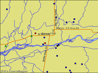
Points of interest:
Notable locations in Bloomfield: Bloomfield Weather Station (A), Bloomfield Fire Department (B), United States Forest Service Bloomfield (C), Bloomfield Fire Department Station 2 (D). Display/hide their locations on the map
Churches in Bloomfield include: First Assembly of God Church (A), Saint Marys Church (B), Church of Christ (C), Nageezi-Deer Spring Church (D), The Church of Jesus Christ of Latter Day Saints (E), Light of His Way Church (F), Bible Baptist Shepherd Church (G), Seventh Day Adventist-Bloomfield Church (H), Calvary Southern Baptist Church (I). Display/hide their locations on the map
Tourist attraction: Salmon Ruins Museum (6131 Highway 64).
Hotels: Soaring Eagle Lodge & Fly Shop (50 Road 4370), Bloomfield Motel (801 W Broadway Ave), Best Western Territorial Inn (415 South Bloomfield Boulevard).
Court: Bloomfield City Government - Municipal Court (915 North 1st Street).
Drinking water stations with addresses in Bloomfield and their reported violations in the past:
BLOOMFIELD WATER SUPPLY SYSTEM (Population served: 7,433, Surface water):Past health violations:Past monitoring violations:
- MCL, Average - Between OCT-2007 and DEC-2007, Contaminant: Total Haloacetic Acids (HAA5). Follow-up actions: St Public Notif received (AUG-19-2008), St Compliance achieved (2 times from DEC-03-2008 to DEC-01-2009)
- Treatment Technique (SWTR and GWR) - In APR-2007. Follow-up actions: St Compliance achieved (2 times from FEB-06-2008 to AUG-19-2008)
- Treatment Technique (SWTR and GWR) - In MAR-2007. Follow-up actions: St AO (w/o penalty) issued (APR-28-2006), St Public Notif requested (APR-03-2007), St Compliance achieved (2 times from FEB-06-2008 to AUG-19-2008)
- Treatment Technique (SWTR and GWR) - In FEB-2007. Follow-up actions: St AO (w/o penalty) issued (APR-28-2006), St Compliance achieved (2 times from FEB-06-2008 to AUG-19-2008)
- Treatment Technique (SWTR and GWR) - In JAN-2007. Follow-up actions: St AO (w/o penalty) issued (APR-28-2006), St Compliance achieved (2 times from FEB-06-2008 to AUG-19-2008)
- MCL, Average - Between JUL-2006 and SEP-2006, Contaminant: Total Haloacetic Acids (HAA5). Follow-up actions: St Public Notif requested (JUL-13-2007), St Compliance achieved (2 times from AUG-19-2008 to DEC-03-2008)
- 13 other older health violations
- Monitoring, Repeat Major (TCR) - In MAR-2014, Contaminant: Coliform (TCR). Follow-up actions: St Violation/Reminder Notice (APR-14-2014), St Public Notif requested (APR-14-2014)
- Monitoring, Source Water (LT2) - In AUG-2009, Contaminant: E. COLI. Follow-up actions: St Compliance achieved (AUG-31-2009)
- Monitoring and Reporting (DBP) - Between JUL-2007 and SEP-2007, Contaminant: Total Haloacetic Acids (HAA5). Follow-up actions: St Compliance achieved (DEC-03-2008)
- Monitoring and Reporting (DBP) - Between JUL-2007 and SEP-2007, Contaminant: TTHM. Follow-up actions: St Compliance achieved (DEC-03-2008)
- Initial Tap Sampling for Pb and Cu - In MAY-01-2005, Contaminant: Lead and Copper Rule. Follow-up actions: St Public Notif requested (MAY-16-2005), St Violation/Reminder Notice (MAY-16-2005), St Public Notif received (JUL-06-2005), St Compliance achieved (DEC-03-2008)
| This city: | 2.8 people |
| New Mexico: | 2.5 people |
| This city: | 71.5% |
| Whole state: | 65.5% |
| This city: | 9.9% |
| Whole state: | 8.2% |
Likely homosexual households (counted as self-reported same-sex unmarried-partner households)
- Lesbian couples: 0.2% of all households
- Gay men: 0.2% of all households
87 people in nursing homes in 2000
Banks with branches in Bloomfield (2011 data):
- Wells Fargo Bank, National Association: Bloomfield Branch at 1200 West Broadway Ave, branch established on 1986/06/16. Info updated 2011/04/05: Bank assets: $1,161,490.0 mil, Deposits: $905,653.0 mil, headquarters in Sioux Falls, SD, positive income, 6395 total offices, Holding Company: Wells Fargo & Company
- Bank of the Southwest: Bloomfield Branch at 920 N. 1st Street, branch established on 2007/07/24. Info updated 2006/11/03: Bank assets: $156.7 mil, Deposits: $138.0 mil, headquarters in Roswell, NM, positive income, Commercial Lending Specialization, 14 total offices, Holding Company: New Mexico National Financial Incorporated
- The Citizens Bank: Bloomfield Branch at 320 West Broadway, branch established on 1958/12/08. Info updated 2008/06/17: Bank assets: $645.1 mil, Deposits: $516.7 mil, headquarters in Farmington, NM, positive income, Mortgage Lending Specialization, 6 total offices, Holding Company: Employee Stock Bonus Trust For The Employees
For population 15 years and over in Bloomfield:
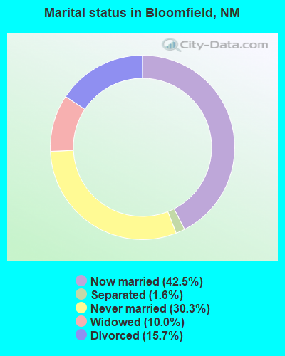
- Never married: 30.3%
- Now married: 42.5%
- Separated: 1.6%
- Widowed: 10.0%
- Divorced: 15.7%
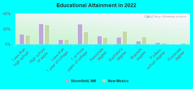
For population 25 years and over in Bloomfield:
- High school or higher: 86.7%
- Bachelor's degree or higher: 14.2%
- Graduate or professional degree: 6.3%
- Unemployed: 7.8%
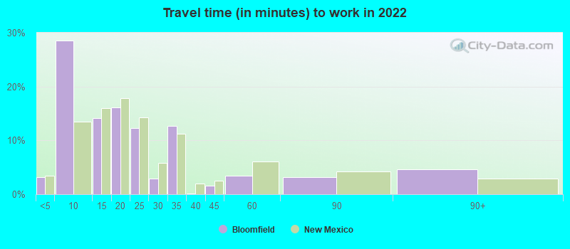
- Mean travel time to work (commute): 30.0 minutes
| Here: | 10.0 |
| New Mexico average: | 12.6 |
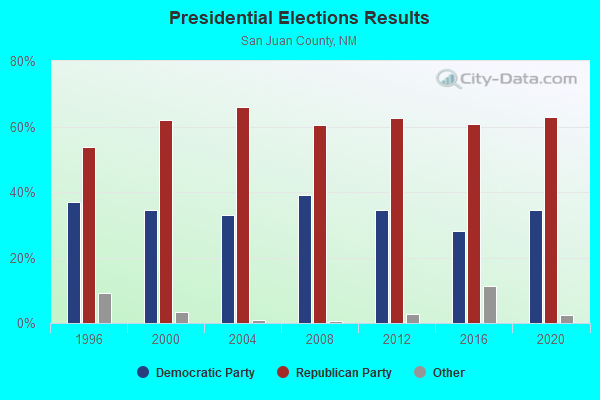
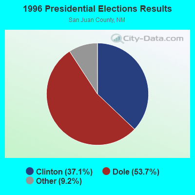

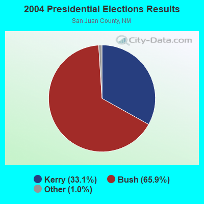
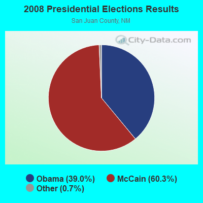
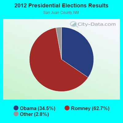
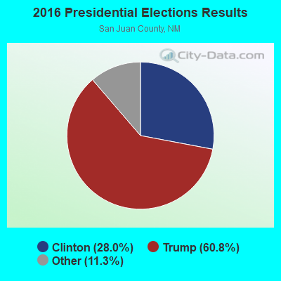

Graphs represent county-level data. Detailed 2008 Election Results
Religion statistics for Bloomfield, NM (based on San Juan County data)
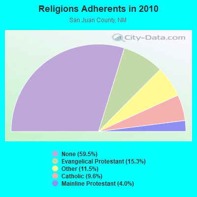
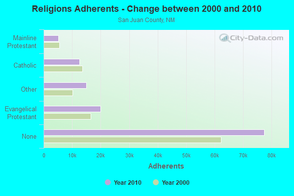
| Religion | Adherents | Congregations |
|---|---|---|
| Evangelical Protestant | 19,905 | 115 |
| Other | 15,001 | 31 |
| Catholic | 12,500 | 11 |
| Mainline Protestant | 5,222 | 16 |
| None | 77,416 | - |
Food Environment Statistics:
| This county: | 0.82 / 10,000 pop. |
| State: | 1.44 / 10,000 pop. |
| San Juan County: | 0.16 / 10,000 pop. |
| New Mexico: | 0.21 / 10,000 pop. |
| This county: | 0.41 / 10,000 pop. |
| New Mexico: | 0.32 / 10,000 pop. |
| San Juan County: | 5.73 / 10,000 pop. |
| State: | 4.06 / 10,000 pop. |
| San Juan County: | 5.07 / 10,000 pop. |
| New Mexico: | 7.12 / 10,000 pop. |
| San Juan County: | 7.3% |
| New Mexico: | 6.4% |
| San Juan County: | 26.4% |
| New Mexico: | 22.1% |
Health and Nutrition:
| This city: | 48.0% |
| New Mexico: | 49.0% |
| Bloomfield: | 46.1% |
| New Mexico: | 48.1% |
| This city: | 28.8 |
| State: | 28.6 |
| This city: | 23.2% |
| New Mexico: | 20.7% |
| This city: | 10.3% |
| New Mexico: | 10.1% |
| Here: | 6.8 |
| New Mexico: | 6.8 |
| This city: | 33.9% |
| New Mexico: | 34.6% |
| Bloomfield: | 54.9% |
| State: | 55.9% |
| Bloomfield: | 79.6% |
| State: | 80.3% |
More about Health and Nutrition of Bloomfield, NM Residents
| Local government employment and payroll (March 2022) | |||||
| Function | Full-time employees | Monthly full-time payroll | Average yearly full-time wage | Part-time employees | Monthly part-time payroll |
|---|---|---|---|---|---|
| Police Protection - Officers | 18 | $102,423 | $68,282 | 0 | $0 |
| Streets and Highways | 14 | $55,063 | $47,197 | 0 | $0 |
| Financial Administration | 8 | $59,114 | $88,671 | 0 | $0 |
| Parks and Recreation | 7 | $24,258 | $41,585 | 6 | $4,192 |
| Water Supply | 5 | $21,823 | $52,375 | 0 | $0 |
| Police - Other | 5 | $14,322 | $34,373 | 0 | $0 |
| Welfare | 4 | $11,277 | $33,831 | 2 | $3,552 |
| Sewerage | 4 | $19,746 | $59,238 | 0 | $0 |
| Other Government Administration | 4 | $21,685 | $65,055 | 6 | $5,258 |
| Judicial and Legal | 2 | $6,420 | $38,520 | 3 | $1,582 |
| Local Libraries | 2 | $7,300 | $43,800 | 2 | $2,055 |
| Totals for Government | 73 | $343,432 | $56,455 | 19 | $16,639 |
Bloomfield government finances - Expenditure in 2021 (per resident):
- Construction - Solid Waste Management: $6,008,000 ($819.09)
Regular Highways: $464,000 ($63.26)
- Current Operations - Police Protection: $2,001,000 ($272.80)
Central Staff Services: $1,582,000 ($215.68)
Local Fire Protection: $1,165,000 ($158.83)
Miscellaneous Commercial Activities - Other: $1,097,000 ($149.56)
Regular Highways: $1,005,000 ($137.01)
Solid Waste Management: $738,000 ($100.61)
Water Utilities: $528,000 ($71.98)
Parks and Recreation: $440,000 ($59.99)
Sewerage: $310,000 ($42.26)
Financial Administration: $282,000 ($38.45)
Judicial and Legal Services: $165,000 ($22.49)
Libraries: $100,000 ($13.63)
Health - Other: $98,000 ($13.36)
Protective Inspection and Regulation - Other: $48,000 ($6.54)
Correctional Institutions: $30,000 ($4.09)
- General - Interest on Debt: $448,000 ($61.08)
- Other Capital Outlay - Police Protection: $169,000 ($23.04)
Miscellaneous Commercial Activities - Other: $154,000 ($21.00)
- Total Salaries and Wages: $5,006,000 ($682.48)
Bloomfield government finances - Revenue in 2021 (per resident):
- Charges - Sewerage: $1,410,000 ($192.23)
Solid Waste Management: $735,000 ($100.20)
Other: $609,000 ($83.03)
Parks and Recreation: $80,000 ($10.91)
- Federal Intergovernmental - Other: $4,773,000 ($650.72)
- Local Intergovernmental - Other: $7,000 ($0.95)
- Miscellaneous - Donations From Private Sources: $128,000 ($17.45)
Fines and Forfeits: $124,000 ($16.91)
Sale of Property: $31,000 ($4.23)
Interest Earnings: $18,000 ($2.45)
Rents: $2,000 ($0.27)
- Revenue - Water Utilities: $2,401,000 ($327.33)
- State Intergovernmental - Other: $2,868,000 ($391.00)
General Local Government Support: $329,000 ($44.85)
Highways: $120,000 ($16.36)
- Tax - General Sales and Gross Receipts: $5,755,000 ($784.59)
Property: $873,000 ($119.02)
Public Utilities Sales: $204,000 ($27.81)
Other Selective Sales: $50,000 ($6.82)
Motor Vehicle License: $42,000 ($5.73)
Occupation and Business License - Other: $21,000 ($2.86)
Alcoholic Beverage License: $1,000 ($0.14)
Bloomfield government finances - Debt in 2021 (per resident):
- Long Term Debt - Beginning Outstanding - Unspecified Public Purpose: $13,465,000 ($1835.72)
Outstanding Unspecified Public Purpose: $12,765,000 ($1740.29)
Retired Unspecified Public Purpose: $700,000 ($95.43)
Bloomfield government finances - Cash and Securities in 2021 (per resident):
- Other Funds - Cash and Securities: $7,789,000 ($1061.90)
| Businesses in Bloomfield, NM | ||||
| Name | Count | Name | Count | |
|---|---|---|---|---|
| Ace Hardware | 1 | FedEx | 1 | |
| Alco Stores | 1 | KFC | 1 | |
| AutoZone | 1 | SONIC Drive-In | 1 | |
| Best Western | 1 | Subway | 1 | |
| Burger King | 1 | Super 8 | 1 | |
| Dairy Queen | 1 | UPS | 1 | |
| Domino's Pizza | 1 | |||
Strongest AM radio stations in Bloomfield:
- KENN (1390 AM; 10 kW; FARMINGTON, NM; Owner: WINTON ROAD BROADCASTING CO, LLC)
- KRZE (1280 AM; 5 kW; FARMINGTON, NM; Owner: J. THOMAS DEVELOPMENT OF NM, INC.)
- KNDN (960 AM; 5 kW; FARMINGTON, NM; Owner: BASIN BROADCASTING CO.)
- KCQL (1340 AM; 1 kW; AZTEC, NM; Owner: CAPSTAR TX LIMITED PARTNERSHIP)
- KTNN (660 AM; 50 kW; WINDOW ROCK, AZ; Owner: THE NAVAJO NATION)
- KHAC (880 AM; 43 kW; TSE BONITO, NM; Owner: WESTERN INDIAN MINISTRIES, INC.)
- KKOB (770 AM; 50 kW; ALBUQUERQUE, NM; Owner: CITADEL BROADCASTING COMPANY)
- KIUP (930 AM; 5 kW; DURANGO, CO; Owner: FOUR CORNERS BROADCASTING, LLC)
- KLLV (550 AM; daytime; 2 kW; BREEN, CO; Owner: DAYSTAR RADIO, LTD.)
- KNZZ (1100 AM; 50 kW; GRAND JUNCTION, CO; Owner: M B C GRAND BROADCASTING, INC.)
- KLTT (670 AM; 50 kW; COMMERCE CITY, CO; Owner: KLZ RADIO, INC.)
- KOA (850 AM; 50 kW; DENVER, CO; Owner: JACOR BROADCASTING OF COLORADO, INC.)
- KKZN (760 AM; 50 kW; THORNTON, CO; Owner: JACOR BROADCASTING OF COLORADO, INC.)
Strongest FM radio stations in Bloomfield:
- KDAG (96.9 FM; FARMINGTON, NM; Owner: CAPSTAR TX LIMITED PARTNERSHIP)
- KAZX (102.9 FM; KIRTLAND, NM; Owner: CAPSTAR TX LIMITED PARTNERSHIP)
- KTRA-FM (102.1 FM; FARMINGTON, NM; Owner: CAPSTAR TX LIMITED PARTNERSHIP)
- KKFG (104.5 FM; BLOOMFIELD, NM; Owner: CAPSTAR TX LIMITED PARTNERSHIP)
- KNMI (88.9 FM; FARMINGTON, NM; Owner: NAVAJO MISSIONS, INC.)
- KISZ-FM1 (97.9 FM; FARMINGTON, NM; Owner: WINTON ROAD BROADCASTING CO, LLC)
- K287AC (105.3 FM; FARMINGTON, NM; Owner: KUTE, INC.)
- K230AF (93.9 FM; KIRTLAND, NM; Owner: CAPSTAR TX LIMITED PARTNERSHIP)
- KWYK-FM (94.9 FM; AZTEC, NM; Owner: BASIN BROADCASTING COMPANY)
- K232DA (94.3 FM; HESPERUS, CO; Owner: NATIVE AMERICAN CHRISTIAN VOICE, INC.)
- K237CR (95.3 FM; HESPERUS, CO; Owner: NATIVE AMERICAN CHRISTIAN VOICE, INC.)
- KRTZ (98.7 FM; CORTEZ, CO; Owner: WINTON ROAD BROADCASTING CO., LLC)
- K220EM (91.9 FM; DZILTH-NA-O-DITH-HLE, NM; Owner: THE REGENTS OF THE UNIV. OF N.M.)
- KPCL (95.7 FM; FARMINGTON, NM; Owner: VOICE MINISTRIES OF FARMINGTON)
- KSJE (90.9 FM; FARMINGTON, NM; Owner: SAN JUAN COLLEGE)
- KRWN (92.9 FM; FARMINGTON, NM; Owner: WINTON ROAD BROADCASTING CO, LLC)
- KIQX (101.3 FM; DURANGO, CO; Owner: FOUR CORNERS BROADCASTINGS, LLC)
- KRSJ (100.5 FM; DURANGO, CO; Owner: FOUR CORNERS BROADCASTING, LLC)
- KUTE (90.1 FM; IGNACIO, CO; Owner: KUTE, INC.)
- K210BA (89.9 FM; PURGATORY, ETC., CO; Owner: KUTE, INC.)
TV broadcast stations around Bloomfield:
- K08HQ (Channel 8; CHINLE, AZ; Owner: KOB-TV, LLC)
- K47DR (Channel 47; FARMINGTON, NM; Owner: CHRISTIAN B/CING COMMUNICATIONS)
- K21AX (Channel 21; FARMINGTON, NM; Owner: EMMIS TELEVISION LICENSE CORPORATION)
- K43AI (Channel 43; FARMINGTON, NM; Owner: REGENTS OF THE UNIVERSITY OF NEW MEXICO)
- K38DA (Channel 38; AZTEC, NM; Owner: REGENTS OF THE UNIV. OF NEW MEXICO)
- K19CM (Channel 19; FARMINGTON, NM; Owner: KOAT HEARST-ARGYLE TELEVISION, INC.)
- K61BO (Channel 61; BAYFIELD/IGNACIO, CO; Owner: RAYCOM NATIONAL INC.)
- K23BT (Channel 23; FARMINGTON, NM; Owner: ACME TELEVISION LICENSES OF NEW MEXICO, LLC)
- K27GJ (Channel 27; FARMINGTON, NM; Owner: RAYCOM NATIONAL, INC.)
- KOBF (Channel 12; FARMINGTON, NM; Owner: KOB-TV, LLC)
- K09JJ (Channel 9; BLOOMFIELD, ETC., NM; Owner: KOAT HEARST-ARGYLE TELEVISION, INC.)
- K11JO (Channel 11; BLOOMFIELD, ETC., NM; Owner: EMMIS TELEVISION LICENSE CORPORATION)
- K08FR (Channel 8; AZTEC, NM; Owner: EMMIS TELEVISION LICENSE CORPORATION)
- K10CG (Channel 10; AZTEC & CEDAR HILL, NM; Owner: KOAT HEARST-ARGYLE TELEVISION, INC.)
- National Bridge Inventory (NBI) Statistics
- 24Number of bridges
- 322ft / 97.8mTotal length
- $10,900,000Total costs
- 132,461Total average daily traffic
- 14,641Total average daily truck traffic
- 158,966Total future (year 2040) average daily traffic
- New bridges - historical statistics
- 21940-1949
- 41950-1959
- 51960-1969
- 11970-1979
- 11980-1989
- 71990-1999
- 22000-2009
- 22010-2019
FCC Registered Cell Phone Towers:
3 (See the full list of FCC Registered Cell Phone Towers in Bloomfield)FCC Registered Antenna Towers:
118 (See the full list of FCC Registered Antenna Towers)FCC Registered Private Land Mobile Towers:
1 (See the full list of FCC Registered Private Land Mobile Towers in Bloomfield, NM)FCC Registered Broadcast Land Mobile Towers:
35 (See the full list of FCC Registered Broadcast Land Mobile Towers)FCC Registered Microwave Towers:
227 (See the full list of FCC Registered Microwave Towers in this town)FCC Registered Paging Towers:
2 (See the full list of FCC Registered Paging Towers)FCC Registered Amateur Radio Licenses:
50 (See the full list of FCC Registered Amateur Radio Licenses in Bloomfield)FAA Registered Aircraft:
5- Aircraft: TOPDOG ULTRALIGHTS 582 (Category: Land, Seats: 2, Weight: Up to 12,499 Pounds), Engine: ROTAX 582SER (65 HP) (2 Cycle)
N-Number: 3330C, N3330C, N-3330C, Serial Number: C0A02TDA, Year manufactured: 2000, Airworthiness Date: 10/25/2007, Certificate Issue Date: 09/06/2016
Registrant (Individual): John A Hawkins, 29 Road 5255, Bloomfield, NM 87413 - Aircraft: CESSNA 182H (Category: Land, Seats: 4, Weight: Up to 12,499 Pounds, Speed: 119 mph), Engine: CONT MOTOR O-470 SERIES (230 HP) (Reciprocating)
N-Number: 3497S, N3497S, N-3497S, Serial Number: 18255897, Year manufactured: 1964, Airworthiness Date: 12/24/1964, Certificate Issue Date: 10/10/2008
Registrant (Individual): Bruce N Henry, 87 Road 5117, Bloomfield, NM 87413 - Aircraft: BOWEN C BRUCE RIDGE RUNNER IIIS (Category: Land, Seats: 2, Weight: Up to 12,499 Pounds), Engine: ROTAX 503 SERIES (52 HP) (Reciprocating)
N-Number: 506NB, N506NB, N-506NB, Serial Number: 01213070139S, Year manufactured: 2014, Airworthiness Date: 10/02/2014, Certificate Issue Date: 01/22/2014
Registrant (Individual): C Bruce Bowen, 1108 N Chaparral St, Bloomfield, NM 87413 - Aircraft: BEECH C23 (Category: Land, Seats: 4, Weight: Up to 12,499 Pounds, Speed: 116 mph), Engine: LYCOMING O&VO-360 SER (180 HP) (Reciprocating)
N-Number: 6707X, N6707X, N-6707X, Serial Number: M-2241, Year manufactured: 1980, Airworthiness Date: 07/22/1980, Certificate Issue Date: 08/25/2011
Registrant (Individual): Stephen Gromack, 1411 Elizabeth St, Bloomfield, NM 87413 - Aircraft: CESSNA 150K (Category: Land, Seats: 2, Weight: Up to 12,499 Pounds, Speed: 90 mph), Engine: CONT MOTOR 0-200 SERIES (100 HP) (Reciprocating)
N-Number: 855JW, N855JW, N-855JW, Serial Number: 15071147, Year manufactured: 1970, Airworthiness Date: 09/01/1986, Certificate Issue Date: 04/22/2015
Registrant (Co-Owned): Bruce N Henry, 87 Road 5117, Bloomfield, NM 87413, Other Owners: Scott M Henry
2004 - 2018 National Fire Incident Reporting System (NFIRS) incidents
- Fire incident types reported to NFIRS in Bloomfield, NM
- 92152.3%Outside Fires
- 58032.9%Structure Fires
- 1639.3%Mobile Property/Vehicle Fires
- 975.5%Other
 Based on the data from the years 2004 - 2018 the average number of fire incidents per year is 117. The highest number of fire incidents - 155 took place in 2013, and the least - 58 in 2007. The data has a rising trend.
 When looking into fire subcategories, the most incidents belonged to: Outside Fires (52.3%), and Structure Fires (32.9%).
Fire-safe hotels and motels in Bloomfield, New Mexico:
- Bloomfield Motel, 801 W Broadway, Bloomfield, New Mexico 87413 , Phone: (505) 632-3383
- Best Western Territorial Inn & Suites, 415 S Bloomfield Blvd, Bloomfield, New Mexico 87413 , Phone: (505) 632-9100, Fax: (505) 632-9191
| Most common first names in Bloomfield, NM among deceased individuals | ||
| Name | Count | Lived (average) |
|---|---|---|
| James | 38 | 74.0 years |
| Mary | 38 | 79.7 years |
| John | 35 | 77.2 years |
| Robert | 28 | 67.3 years |
| William | 25 | 77.6 years |
| Charles | 22 | 72.6 years |
| David | 20 | 65.3 years |
| George | 19 | 76.8 years |
| Paul | 14 | 78.3 years |
| Richard | 13 | 68.1 years |
| Most common last names in Bloomfield, NM among deceased individuals | ||
| Last name | Count | Lived (average) |
|---|---|---|
| Yazzie | 24 | 71.1 years |
| Begay | 23 | 76.4 years |
| Brown | 18 | 76.3 years |
| Smith | 18 | 75.3 years |
| Armenta | 17 | 68.9 years |
| Johnson | 17 | 71.4 years |
| Gonzales | 17 | 68.1 years |
| Wilson | 15 | 75.6 years |
| Sandoval | 14 | 77.3 years |
| Williams | 13 | 72.1 years |
- 79.5%Utility gas
- 14.0%Electricity
- 3.4%Wood
- 2.8%Bottled, tank, or LP gas
- 0.4%Other fuel
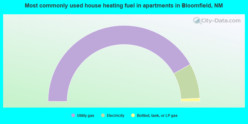
- 83.8%Utility gas
- 14.9%Electricity
- 1.3%Bottled, tank, or LP gas
Bloomfield compared to New Mexico state average:
- Unemployed percentage below state average.
- Black race population percentage significantly below state average.
- Median age below state average.
- Foreign-born population percentage significantly below state average.
- Length of stay since moving in above state average.
Bloomfield on our top lists:
- #41 on the list of "Top 101 cities with largest percentage of females in occupations: architecture and engineering occupations (population 5,000+)"
- #48 on the list of "Top 101 cities with largest percentage of males in industries: mining, quarrying, and oil and gas extraction (population 5,000+)"
- #52 on the list of "Top 101 cities with largest percentage of females in industries: construction (population 5,000+)"
- #55 on the list of "Top 101 cities with largest percentage of females in occupations: office and administrative support occupations (population 5,000+)"
- #86 on the list of "Top 101 cities with the largest percentage of mobile homes (2,000+ housing units)"
- #29 (87413) on the list of "Top 101 zip codes with the largest percentage of English first ancestries (pop 5,000+)"
- #3 on the list of "Top 101 counties with the largest number of people moving out compared to moving in (pop. 50,000+)"
- #13 on the list of "Top 101 counties with the lowest percentage of residents that visited a dentist within the past year"
- #16 on the list of "Top 101 counties with highest percentage of residents voting for 3rd party candidates in the 2012 Presidential Election (pop. 50,000+)"
- #21 on the list of "Top 101 counties with the lowest Particulate Matter (PM2.5) Annual air pollution readings in 2012 (µg/m3)"
- #25 on the list of "Top 101 counties with the highest percentage of residents that keep firearms around their homes"

|
|
Total of 9 patent applications in 2008-2024.