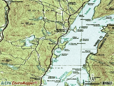
Bolton, New York
Submit your own pictures of this town and show them to the world
- OSM Map
- General Map
- Google Map
- MSN Map
Population change since 2000: +9.9%
 |
| Males: 1,190 | |
| Females: 1,136 |
| Median resident age: | 52.2 years |
| New York median age: | 40.7 years |
Zip codes: 12814.
| Bolton: | $83,655 |
| NY: | $79,557 |
Estimated per capita income in 2022: $51,747 (it was $26,492 in 2000)
Bolton town income, earnings, and wages data
Estimated median house or condo value in 2022: $387,450 (it was $141,900 in 2000)
| Bolton: | $387,450 |
| NY: | $400,400 |
Mean prices in 2022: all housing units: $374,544; detached houses: $390,646; townhouses or other attached units: $238,465; in 2-unit structures: $319,237; in 3-to-4-unit structures: $251,286; in 5-or-more-unit structures: over $1,000,000; mobile homes: $114,441; occupied boats, rvs, vans, etc.: $382,857
Detailed information about poverty and poor residents in Bolton, NY


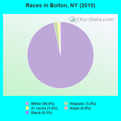
- 2,24696.6%White alone
- 431.8%Hispanic
- 241.0%Two or more races
- 90.4%Asian alone
- 30.1%Black alone
- 10.04%Native Hawaiian and Other
Pacific Islander alone
Races in Bolton detailed stats: ancestries, foreign born residents, place of birth
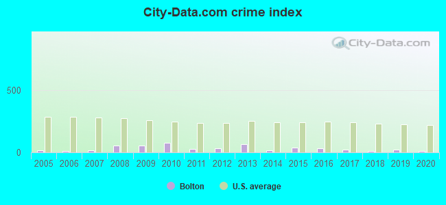
Type |
2009 |
2010 |
2011 |
2012 |
2013 |
2014 |
2015 |
2016 |
2017 |
2018 |
2019 |
2020 |
|---|---|---|---|---|---|---|---|---|---|---|---|---|
| Murders (per 100,000) | 0 (0.0) | 0 (0.0) | 0 (0.0) | 0 (0.0) | 0 (0.0) | 0 (0.0) | 0 (0.0) | 0 (0.0) | 0 (0.0) | 0 (0.0) | 0 (0.0) | 0 (0.0) |
| Rapes (per 100,000) | 0 (0.0) | 0 (0.0) | 0 (0.0) | 0 (0.0) | 0 (0.0) | 0 (0.0) | 0 (0.0) | 0 (0.0) | 0 (0.0) | 0 (0.0) | 0 (0.0) | 0 (0.0) |
| Robberies (per 100,000) | 0 (0.0) | 0 (0.0) | 0 (0.0) | 0 (0.0) | 0 (0.0) | 0 (0.0) | 0 (0.0) | 0 (0.0) | 0 (0.0) | 0 (0.0) | 0 (0.0) | 0 (0.0) |
| Assaults (per 100,000) | 2 (92.7) | 3 (129.0) | 0 (0.0) | 2 (85.3) | 2 (86.0) | 0 (0.0) | 1 (43.4) | 1 (43.8) | 1 (44.1) | 0 (0.0) | 0 (0.0) | 0 (0.0) |
| Burglaries (per 100,000) | 3 (139.0) | 10 (429.9) | 1 (42.8) | 2 (85.3) | 4 (172.0) | 3 (129.3) | 2 (86.9) | 4 (175.1) | 1 (44.1) | 3 (132.9) | 1 (44.4) | 0 (0.0) |
| Thefts (per 100,000) | 13 (602.4) | 13 (558.9) | 14 (599.3) | 6 (256.0) | 20 (860.2) | 6 (258.5) | 13 (564.7) | 5 (218.9) | 5 (220.3) | 2 (88.6) | 8 (355.4) | 6 (268.0) |
| Auto thefts (per 100,000) | 0 (0.0) | 0 (0.0) | 0 (0.0) | 0 (0.0) | 0 (0.0) | 0 (0.0) | 1 (43.4) | 1 (43.8) | 0 (0.0) | 0 (0.0) | 1 (44.4) | 0 (0.0) |
| Arson (per 100,000) | 0 (0.0) | 0 (0.0) | 0 (0.0) | 0 (0.0) | 0 (0.0) | 0 (0.0) | 0 (0.0) | 0 (0.0) | 0 (0.0) | 0 (0.0) | 0 (0.0) | 0 (0.0) |
| City-Data.com crime index | 52.4 | 78.2 | 27.0 | 33.3 | 63.7 | 19.4 | 40.8 | 33.3 | 20.7 | 12.8 | 20.9 | 10.7 |
The City-Data.com crime index weighs serious crimes and violent crimes more heavily. Higher means more crime, U.S. average is 246.1. It adjusts for the number of visitors and daily workers commuting into cities.
Crime rate in Bolton detailed stats: murders, rapes, robberies, assaults, burglaries, thefts, arson
 Recent articles from our blog. Our writers, many of them Ph.D. graduates or candidates, create easy-to-read articles on a wide variety of topics.


 | More disappearing stores: Bolton/Strawberry (35 replies) |
| Graduation videos… (38 replies) |
| Glens Falls development... (117 replies) |
| Downstate counties have highest rates of students in private schools. Check your district (3 replies) |
| BLM protesters scream ‘we don’t want you here’ at diners outside NYC restaurant (46 replies) |
| Cuomo says the APEX is near - really???? (122 replies) |
Latest news from Bolton, NY collected exclusively by city-data.com from local newspapers, TV, and radio stations
Ancestries: Irish (21.4%), English (17.3%), German (16.3%), Italian (12.0%), United States (9.7%), French (5.7%).
Current Local Time: EST time zone
Elevation: 360 feet
Land area: 63.4 square miles.
Population density: 37 people per square mile (very low).
77 residents are foreign born (2.5% Europe, 0.6% Asia).
| This town: | 3.6% |
| New York: | 20.4% |
| Bolton town: | 1.0% ($1,363) |
| New York: | 1.9% ($2,847) |
Nearest city with pop. 50,000+: Schenectady, NY  (53.9 miles , pop. 61,821).
Nearest city with pop. 200,000+: Boston, MA (156.1 miles , pop. 589,141).
Nearest city with pop. 1,000,000+: Bronx, NY (187.9 miles , pop. 1,332,650).
Nearest cities:
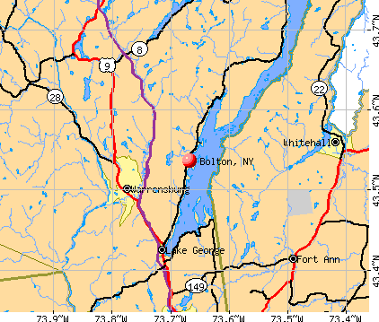
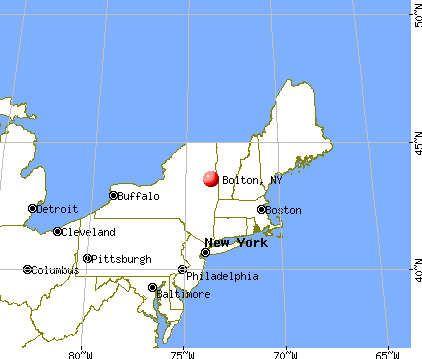
), ), ), Latitude: 43.56 N, Longitude: 73.67 W
Area code commonly used in this area: 518

Bolton tourist attractions:
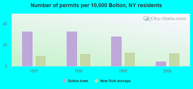
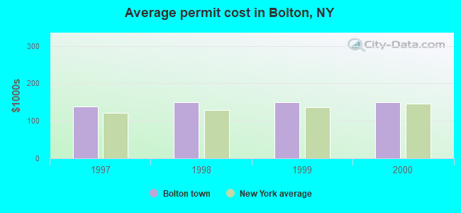
Single-family new house construction building permits:
- 2000: 1 building, cost: $149,900
- 1999: 6 buildings, average cost: $149,900
- 1998: 7 buildings, average cost: $149,900
- 1997: 7 buildings, average cost: $138,100
| Here: | 4.6% |
| New York: | 4.4% |
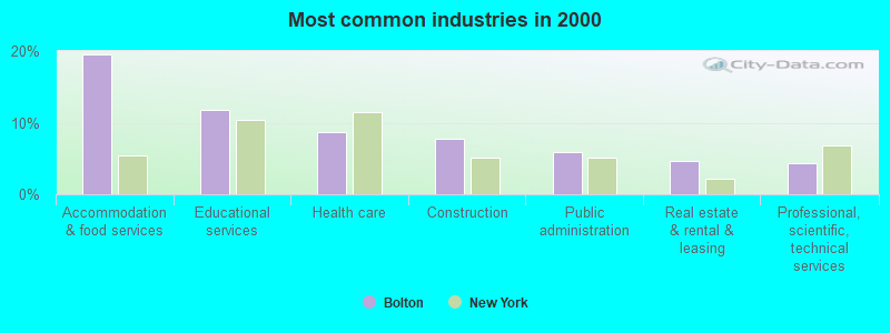
- Accommodation & food services (19.5%)
- Educational services (11.7%)
- Health care (8.6%)
- Construction (7.8%)
- Public administration (5.9%)
- Real estate & rental & leasing (4.6%)
- Professional, scientific, technical services (4.3%)
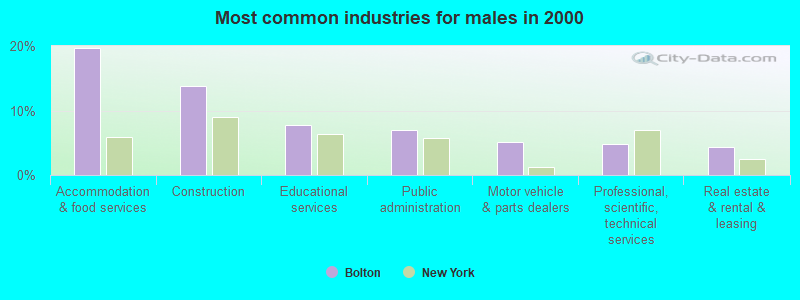
- Accommodation & food services (19.7%)
- Construction (13.8%)
- Educational services (7.8%)
- Public administration (7.0%)
- Motor vehicle & parts dealers (5.1%)
- Professional, scientific, technical services (4.7%)
- Real estate & rental & leasing (4.4%)
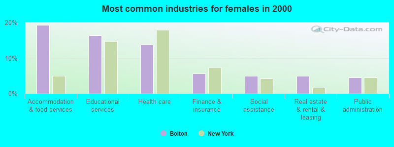
- Accommodation & food services (19.4%)
- Educational services (16.4%)
- Health care (13.7%)
- Finance & insurance (5.6%)
- Social assistance (5.0%)
- Real estate & rental & leasing (5.0%)
- Public administration (4.5%)

- Other sales and related occupations, including supervisors (8.7%)
- Other management occupations, except farmers and farm managers (6.8%)
- Preschool, kindergarten, elementary, and middle school teachers (5.1%)
- Building and grounds cleaning and maintenance occupations (4.5%)
- Other food preparation and serving workers, including supervisors (3.3%)
- Information and record clerks, except customer service representatives (2.6%)
- Registered nurses (2.5%)
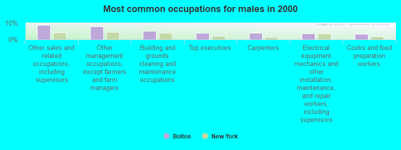
- Other sales and related occupations, including supervisors (8.7%)
- Other management occupations, except farmers and farm managers (7.8%)
- Building and grounds cleaning and maintenance occupations (5.3%)
- Top executives (4.0%)
- Carpenters (3.8%)
- Electrical equipment mechanics and other installation, maintenance, and repair workers, including supervisors (3.6%)
- Cooks and food preparation workers (3.4%)
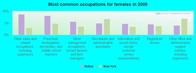
- Other sales and related occupations, including supervisors (8.8%)
- Preschool, kindergarten, elementary, and middle school teachers (8.1%)
- Other management occupations, except farmers and farm managers (5.6%)
- Secretaries and administrative assistants (5.0%)
- Information and record clerks, except customer service representatives (4.7%)
- Registered nurses (4.5%)
- Other office and administrative support workers, including supervisors (4.1%)
Average climate in Bolton, New York
Based on data reported by over 4,000 weather stations


Tornado activity:
Bolton-area historical tornado activity is below New York state average. It is 76% smaller than the overall U.S. average.
On 6/11/1976, a category F2 (max. wind speeds 113-157 mph) tornado 16.7 miles away from the Bolton town center caused between $50,000 and $500,000 in damages.
On 6/24/1960, a category F3 (max. wind speeds 158-206 mph) tornado 44.3 miles away from the town center injured 9 people and caused between $5,000,000 and $50,000,000 in damages.
Earthquake activity:
Bolton-area historical earthquake activity is significantly above New York state average. It is 69% smaller than the overall U.S. average.On 10/7/1983 at 10:18:46, a magnitude 5.3 (5.1 MB, 5.3 LG, 5.1 ML, Class: Moderate, Intensity: VI - VII) earthquake occurred 43.3 miles away from the city center
On 4/20/2002 at 10:50:47, a magnitude 5.3 (5.3 ML, Depth: 3.0 mi) earthquake occurred 65.9 miles away from the city center
On 4/20/2002 at 10:50:47, a magnitude 5.2 (5.2 MB, 4.2 MS, 5.2 MW, 5.0 MW) earthquake occurred 64.2 miles away from the city center
On 1/19/1982 at 00:14:42, a magnitude 4.7 (4.5 MB, 4.7 MD, 4.5 LG, Class: Light, Intensity: IV - V) earthquake occurred 103.8 miles away from the city center
On 10/16/2012 at 23:12:25, a magnitude 4.7 (4.7 ML, Depth: 10.0 mi) earthquake occurred 150.9 miles away from Bolton center
On 6/17/1991 at 08:53:16, a magnitude 4.1 (4.0 MB, 4.0 LG, Depth: 3.1 mi) earthquake occurred 82.0 miles away from the city center
Magnitude types: regional Lg-wave magnitude (LG), body-wave magnitude (MB), duration magnitude (MD), local magnitude (ML), surface-wave magnitude (MS), moment magnitude (MW)
Natural disasters:
The number of natural disasters in Warren County (16) is near the US average (15).Major Disasters (Presidential) Declared: 10
Emergencies Declared: 5
Causes of natural disasters: Floods: 7, Storms: 7, Hurricanes: 4, Winds: 2, Blizzard: 1, Earthquake: 1, Power Outage: 1, Tornado: 1, Other: 2 (Note: some incidents may be assigned to more than one category).
Colleges/universities with over 2000 students nearest to Bolton:
- Adirondack Community College (about 15 miles; Queensbury, NY; Full-time enrollment: 2,826)
- Castleton State College (about 25 miles; Castleton, VT; FT enrollment: 2,079)
- Skidmore College (about 33 miles; Saratoga Springs, NY; FT enrollment: 2,753)
- SUNY Empire State College (about 34 miles; Saratoga Springs, NY; FT enrollment: 9,473)
- Middlebury College (about 40 miles; Middlebury, VT; FT enrollment: 3,077)
- Fulton-Montgomery Community College (about 51 miles; Johnstown, NY; FT enrollment: 2,043)
- Union College (about 53 miles; Schenectady, NY; FT enrollment: 2,075)
Points of interest:
Notable locations in Bolton: The Sagamore Resort and Golf Club (A), Lake George Schroon Valley Resort (B), Bolton Free Library (C), Bolton Historical Museum (D), Bolton Landing Volunteer Fire Company (E), Bolton Landing Volunteer Fire Company Station 2 (F). Display/hide their locations on the map
Cemeteries: Beswick Cemetery (1), Bolton Rural Cemetery (2), Herrick Cemetery (3), Warren County Home Cemetery (4), Federal Hill Cemetery (5), Lamb Hill Cemetery (6), New Vermont Cemetery (7). Display/hide their locations on the map
Lakes: Indian Pond (A), Pole Hill Pond (B), Trout Lake (C), Lake George (D), Wing Pond (E), Edgecomb Pond (F). Display/hide their locations on the map
Streams, rivers, and creeks: Finkle Brook (A), Edmunds Brook (B), Alder Brook (C), Round Pond Brook (D), Northwest Bay Brook (E), Indian Brook (F), Huddle Brook (G). Display/hide their locations on the map
| This town: | 2.2 people |
| New York: | 2.6 people |
| This town: | 63.3% |
| Whole state: | 63.5% |
| This town: | 8.3% |
| Whole state: | 6.8% |
Likely homosexual households (counted as self-reported same-sex unmarried-partner households)
- Lesbian couples: 0.2% of all households
- Gay men: 0.6% of all households
| This town: | 5.6% |
| Whole state: | 14.6% |
| This town: | 3.1% |
| Whole state: | 7.4% |
For population 15 years and over in Bolton:
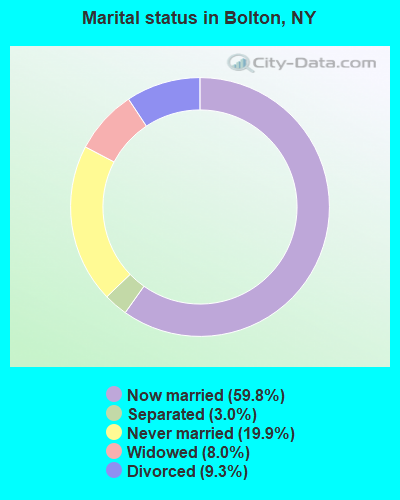
- Never married: 19.9%
- Now married: 59.8%
- Separated: 3.0%
- Widowed: 8.0%
- Divorced: 9.3%
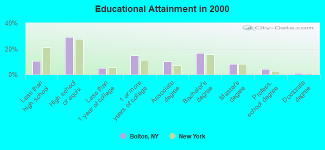
For population 25 years and over in Bolton:
- High school or higher: 89.4%
- Bachelor's degree or higher: 30.3%
- Graduate or professional degree: 13.5%
- Unemployed: 6.8%
- Mean travel time to work (commute): 21.7 minutes
| Here: | 10.7 |
| New York average: | 14.2 |
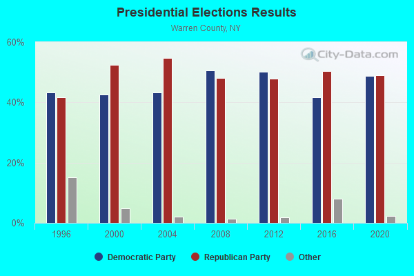
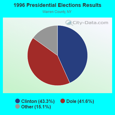
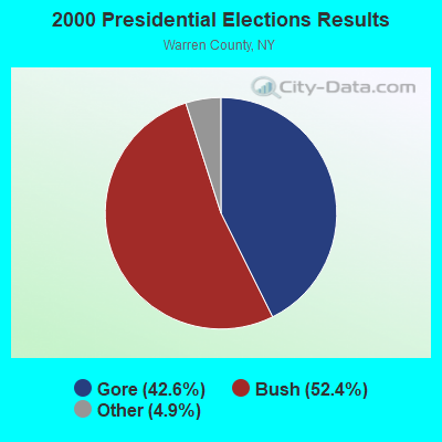
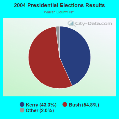
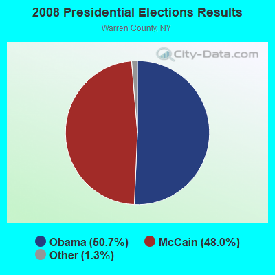

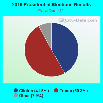
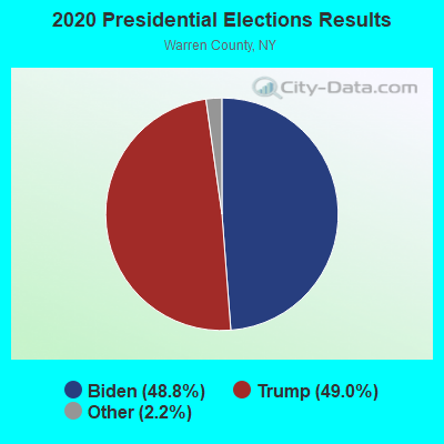
Graphs represent county-level data. Detailed 2008 Election Results
Religion statistics for Bolton, NY (based on Warren County data)
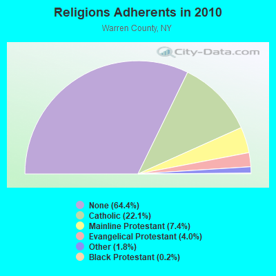
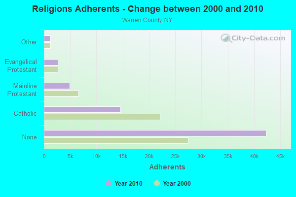
| Religion | Adherents | Congregations |
|---|---|---|
| Catholic | 14,546 | 10 |
| Mainline Protestant | 4,878 | 30 |
| Evangelical Protestant | 2,646 | 22 |
| Other | 1,209 | 7 |
| Black Protestant | 113 | 1 |
| None | 42,315 | - |
Food Environment Statistics:
| Warren County: | 4.70 / 10,000 pop. |
| New York: | 4.13 / 10,000 pop. |
| This county: | 0.15 / 10,000 pop. |
| New York: | 0.06 / 10,000 pop. |
| Here: | 0.46 / 10,000 pop. |
| State: | 0.92 / 10,000 pop. |
| This county: | 5.92 / 10,000 pop. |
| New York: | 1.68 / 10,000 pop. |
| Here: | 20.64 / 10,000 pop. |
| State: | 8.82 / 10,000 pop. |
| This county: | 8.8% |
| New York: | 8.2% |
| Warren County: | 24.4% |
| New York: | 23.8% |
| Warren County: | 13.2% |
| State: | 15.6% |
Strongest AM radio stations in Bolton:
- WGY (810 AM; 50 kW; SCHENECTADY, NY; Owner: CLEAR CHANNEL BROADCASTING LICENSES, INC.)
- WPTR (1540 AM; 50 kW; ALBANY, NY; Owner: KIMTRON, INC.)
- WNNZ (640 AM; 50 kW; WESTFIELD, MA; Owner: CLEAR CHANNEL BROADCASTING LICENSES, INC.)
- WCHP (760 AM; 35 kW; CHAMPLAIN, NY; Owner: CHAMPLAIN RADIO, INC.)
- WICY (1490 AM; 50 kW; MALONE, NY; Owner: CARTIER COMMUNICATIONS INC.)
- WCRN (830 AM; 50 kW; WORCESTER, MA; Owner: CARTER BROADCASTING CORPORATION)
- WRKO (680 AM; 50 kW; BOSTON, MA; Owner: ENTERCOM BOSTON LICENSE, LLC)
- WMML (1230 AM; 1 kW; GLENS FALLS, NY; Owner: VOX NEW YORK, L.L.C.)
- WSYB (1380 AM; 5 kW; RUTLAND, VT; Owner: CAPSTAR TX LIMITED PARTNERSHIP)
- WTIC (1080 AM; 50 kW; HARTFORD, CT; Owner: INFINITY RADIO OPERATIONS INC.)
- WEEI (850 AM; 50 kW; BOSTON, MA; Owner: ENTERCOM BOSTON LICENSE, LLC)
- WWSC (1450 AM; 1 kW; GLENS FALLS, NY; Owner: ENTERTRONICS, INC.)
- WABY (1160 AM; 5 kW; MECHANICVILLE, NY; Owner: ANASTOS MEDIA GROUP, INC.)
Strongest FM radio stations in Bolton:
- WKBE (100.3 FM; WARRENSBURG, NY; Owner: 6 JOHNSON ROAD LICENSES, INC.)
- WCKM-FM (99.1 FM; LAKE GEORGE, NY; Owner: ENTERTRONICS, INC.)
- WNYQ (105.7 FM; QUEENSBURY, NY; Owner: VOX NEW YORK, L.L.C.)
- WXLG (89.9 FM; NORTH CREEK, NY; Owner: THE ST. LAWRENCE UNIVERSITY)
- WBAR-FM (94.7 FM; LAKE LUZERNE, NY; Owner: CAPITAL MEDIA CORPORATION)
- WEQX (102.7 FM; MANCHESTER, VT; Owner: NORTHSHIRE COMMUNICATIONS, INC.)
- WJAN (95.1 FM; SUNDERLAND, VT; Owner: 6 JOHNSON ROAD LICENSES, INC.)
- WCQL (95.9 FM; GLENS FALLS, NY; Owner: ENTERTRONICS, INC.)
- WEBK (105.3 FM; KILLINGTON, VT; Owner: 6 JOHNSON ROAD LICENSES, INC.)
- WJJR (98.1 FM; RUTLAND, VT; Owner: 6 JOHNSON ROAD LICENSES, INC.)
- WZRT (97.1 FM; RUTLAND, VT; Owner: CAPSTAR TX LIMITED PARTNERSHIP)
- WNGN (91.9 FM; ARGYLE, NY; Owner: NORTHEAST GOSPEL BROADCASTING INC)
- WGLV (91.7 FM; WOODSTOCK, VT; Owner: CHRISTIAN MINISTRIES INC)
- WHDQ-FM1 (106.1 FM; RUTLAND, VT; Owner: GREAT NORTHERN RADIO, L.L.C.)
- WFFG-FM (107.1 FM; CORINTH, NY; Owner: VOX NEW YORK, L.L.C.)
- WEXP (101.5 FM; BRANDON, VT; Owner: VOX VERMONT, L.L.C.)
- WKRD (93.7 FM; SCOTIA, NY; Owner: DOT COMMUNICATIONS, INC.)
- WXLH (91.3 FM; BLUE MOUNTAIN LAKE, NY; Owner: THE ST. LAWRENCE UNIVERSITY)
- WNYV (94.1 FM; WHITEHALL, NY; Owner: PINE TREE BROADCASTING COMPANY)
- WDEV-FM (96.1 FM; WARREN, VT; Owner: RADIO VERMONT, INC.)
TV broadcast stations around Bolton:
- W47CM (Channel 47; GLENS FALLS, NY; Owner: TRINITY BROADCASTING NETWORK)
- WNCE-CA (Channel 8; GLENS FALLS, NY; Owner: NORTHERN BROADCASTING COMPANY, INC.)
Medal of Honor Recipients
Medal of Honor Recipient born in Bolton: Lester G. Hack.
- National Bridge Inventory (NBI) Statistics
- 13Number of bridges
- 167ft / 51.4mTotal length
- $21,799,000Total costs
- 34,517Total average daily traffic
- 6,487Total average daily truck traffic

- New bridges - historical statistics
- 21920-1929
- 41960-1969
- 22000-2009
- 42010-2019
- 12020-2022
FCC Registered Antenna Towers:
1- Todd C Scaccia, 236 Wall Street (Lat: 43.512694 Lon: -73.739139), Type: 29.6, Overall height: 27.4 m, Registrant: Wireless Applications Corporation, Fcc@wacorp.Net, , Belle-vue, Phone: (425) 643-5000
FCC Registered Broadcast Land Mobile Towers:
2- RS4_NBolton, 10 Mi. N From Bolton, Via Sr 9n-Cr11-Church Hill Rd-N Bolton Rd On Padanarum Rd. (Lat: 43.634167 Lon: -73.642500), Type: Tower, Structure height: 45.7 m, Call Sign: WPVA640,
Assigned Frequencies: 860.762 MHz, 855.212 MHz, 855.237 MHz, 855.712 MHz, 855.737 MHz, 856.712 MHz, 856.737 MHz, 856.762 MHz, 856.987 MHz, 857.712 MHz... (+12 more), Grant Date: 06/07/2002, Expiration Date: 06/07/2012, Cancellation Date: 11/17/2010, Certifier: Thomas J Cowper, Registrant: Nys Dhses Office Of Interoperable And Emergency Communications, State Office Campus Building 22, 1220 Washington Ave, Albany, NY 12226, Phone: (518) 322-4912, Fax: (518) 322-4975, Email:
- SP_BLKMTN, 8 Mi. N From Bolton, Ny On Sr 9n (Lat: 43.606667 Lon: -73.581667), Type: Tower, Structure height: 50 m, Call Sign: WPVA641,
Assigned Frequencies: 855.212 MHz, 855.237 MHz, 855.462 MHz, 855.712 MHz, 855.737 MHz, 860.762 MHz, 860.987 MHz, 858.762 MHz, 858.987 MHz, 859.737 MHz... (+17 more), Grant Date: 06/07/2002, Expiration Date: 06/07/2012, Cancellation Date: 11/17/2010, Certifier: Thomas J Cowper, Registrant: Nys Dhses Office Of Interoperable And Emergency Communications, State Office Campus Building 22, 1220 Washington Ave, Albany, NY 12226, Phone: (518) 322-4912, Fax: (518) 322-4975, Email:
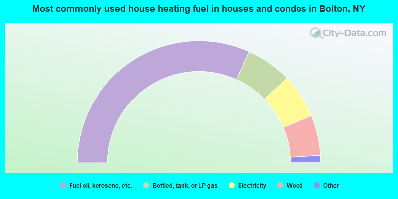
- 63.6%Fuel oil, kerosene, etc.
- 12.0%Bottled, tank, or LP gas
- 11.9%Electricity
- 10.7%Wood
- 0.7%Coal or coke
- 0.7%Other fuel
- 0.5%Utility gas
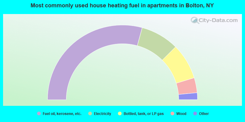
- 58.5%Fuel oil, kerosene, etc.
- 16.5%Electricity
- 15.5%Bottled, tank, or LP gas
- 6.5%Wood
- 2.5%Utility gas
- 0.5%Other fuel
Bolton compared to New York state average:
- Unemployed percentage below state average.
- Black race population percentage significantly below state average.
- Hispanic race population percentage significantly below state average.
- Median age significantly above state average.
- Foreign-born population percentage significantly below state average.
- Renting percentage significantly below state average.
- Length of stay since moving in significantly above state average.
- Number of rooms per house significantly below state average.
- House age significantly below state average.