Broad Fields, Kentucky
Submit your own pictures of this city and show them to the world
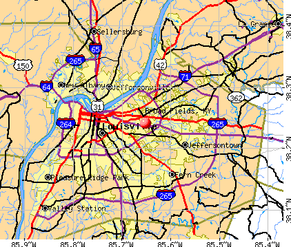
- OSM Map
- General Map
- Google Map
- MSN Map
| Males: 113 | |
| Females: 143 |
| Median resident age: | 55.5 years |
| Kentucky median age: | 35.9 years |
Zip codes: 40207.
| Broad Fields: | $89,050 |
| KY: | $59,341 |
Estimated per capita income in 2022: $50,340 (it was $27,530 in 2000)
Broad Fields city income, earnings, and wages data
Estimated median house or condo value in 2022: $367,724 (it was $152,600 in 2000)
| Broad Fields: | $367,724 |
| KY: | $196,300 |
Mean prices in 2022: all housing units: $289,784; detached houses: $296,246; townhouses or other attached units: $324,768; in 2-unit structures: $229,571; in 3-to-4-unit structures: $142,806; in 5-or-more-unit structures: $199,353; mobile homes: $137,257; occupied boats, rvs, vans, etc.: $80,553


- 24899.2%White alone
- 10.4%Asian alone
- 10.4%Two or more races
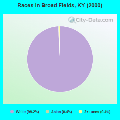
Races in Broad Fields detailed stats: ancestries, foreign born residents, place of birth
 Recent articles from our blog. Our writers, many of them Ph.D. graduates or candidates, create easy-to-read articles on a wide variety of topics.


Ancestries: German (42.4%), Irish (18.8%), English (16.0%), United States (8.0%), Scotch-Irish (6.8%), Italian (4.0%).
Current Local Time: EST time zone
Elevation: 542 feet
Land area: 0.06 square miles.
Population density: 4,237 people per square mile (average).
3 residents are foreign born
| This city: | 1.2% |
| Kentucky: | 2.0% |
| Broad Fields city: | 0.8% ($1,223) |
| Kentucky: | 0.8% ($610) |
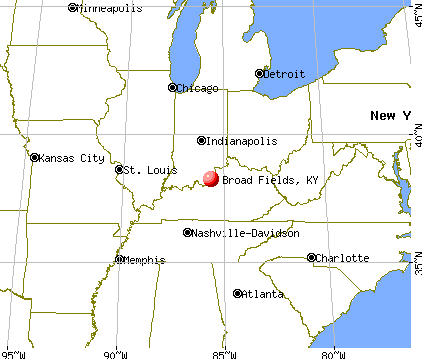
Nearest city with pop. 50,000+: Louisville, KY  (5.4 miles , pop. 256,231).
Nearest city with pop. 1,000,000+: Chicago, IL (271.1 miles , pop. 2,896,016).
Nearest cities:
), ), ), ), ), ), )Latitude: 38.24 N, Longitude: 85.65 W
| Here: | 3.6% |
| Kentucky: | 3.8% |
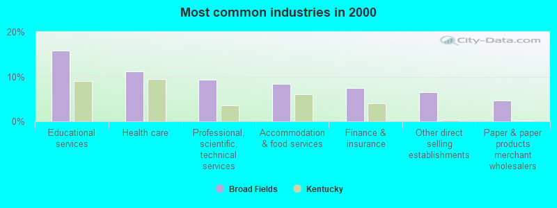
- Educational services (15.9%)
- Health care (11.2%)
- Professional, scientific, technical services (9.3%)
- Accommodation & food services (8.4%)
- Finance & insurance (7.5%)
- Other direct selling establishments (6.5%)
- Paper & paper products merchant wholesalers (4.7%)
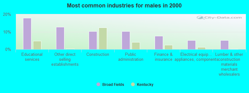
- Educational services (17.9%)
- Other direct selling establishments (12.8%)
- Construction (10.3%)
- Public administration (10.3%)
- Finance & insurance (7.7%)
- Electrical equipment, appliances, components (5.1%)
- Lumber & other construction materials merchant wholesalers (5.1%)
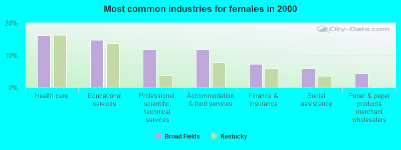
- Health care (16.2%)
- Educational services (14.7%)
- Professional, scientific, technical services (11.8%)
- Accommodation & food services (11.8%)
- Finance & insurance (7.4%)
- Social assistance (5.9%)
- Paper & paper products merchant wholesalers (4.4%)
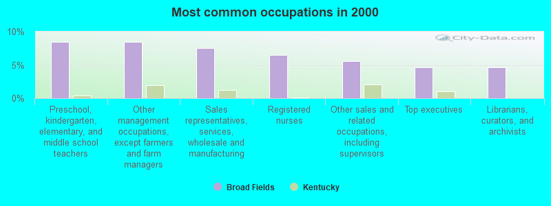
- Preschool, kindergarten, elementary, and middle school teachers (8.4%)
- Other management occupations, except farmers and farm managers (8.4%)
- Sales representatives, services, wholesale and manufacturing (7.5%)
- Registered nurses (6.5%)
- Other sales and related occupations, including supervisors (5.6%)
- Top executives (4.7%)
- Librarians, curators, and archivists (4.7%)
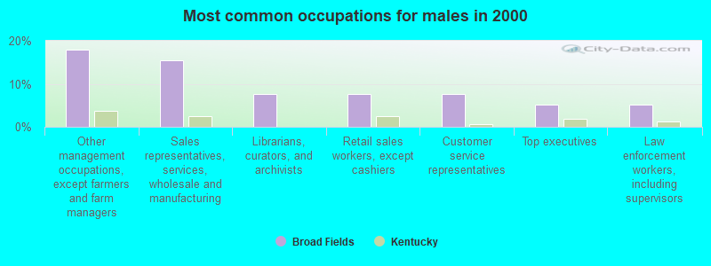
- Other management occupations, except farmers and farm managers (17.9%)
- Sales representatives, services, wholesale and manufacturing (15.4%)
- Librarians, curators, and archivists (7.7%)
- Retail sales workers, except cashiers (7.7%)
- Customer service representatives (7.7%)
- Top executives (5.1%)
- Law enforcement workers, including supervisors (5.1%)
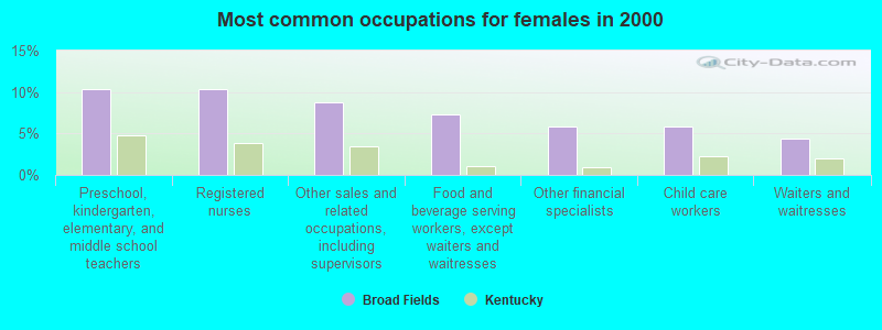
- Preschool, kindergarten, elementary, and middle school teachers (10.3%)
- Registered nurses (10.3%)
- Other sales and related occupations, including supervisors (8.8%)
- Food and beverage serving workers, except waiters and waitresses (7.4%)
- Other financial specialists (5.9%)
- Child care workers (5.9%)
- Waiters and waitresses (4.4%)
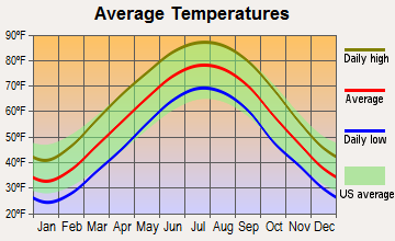
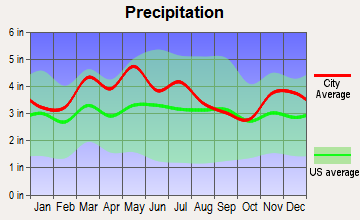
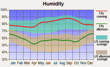
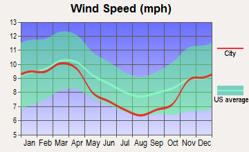
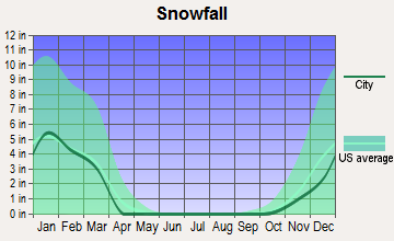
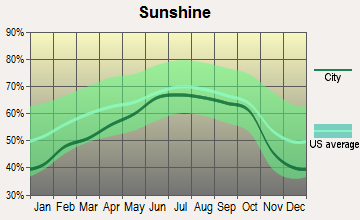
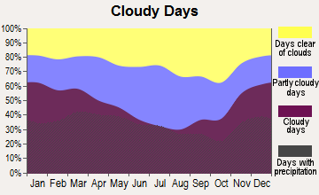
Average climate in Broad Fields, Kentucky
Based on data reported by over 4,000 weather stations
(lower is better)
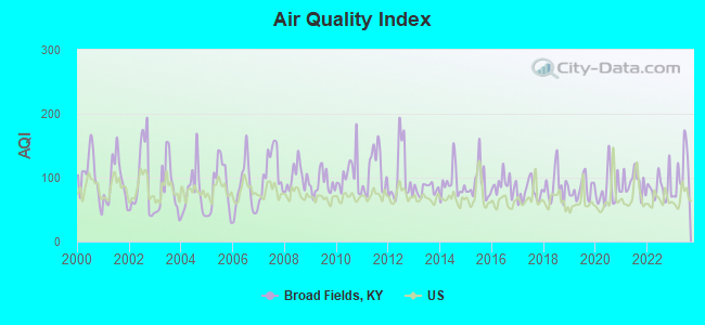
Air Quality Index (AQI) level in 2023 was 109. This is significantly worse than average.
| City: | 109 |
| U.S.: | 73 |
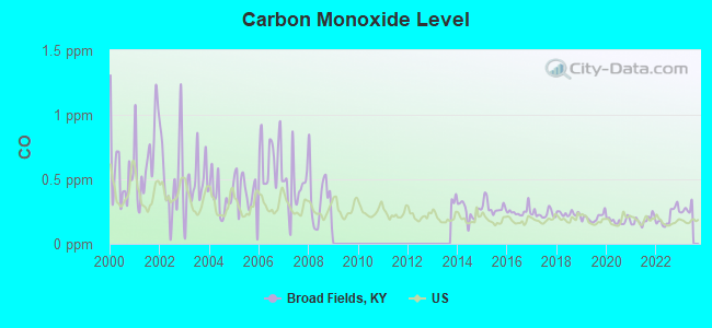
Carbon Monoxide (CO) [ppm] level in 2022 was 0.208. This is better than average. Closest monitor was 0.9 miles away from the city center.
| City: | 0.208 |
| U.S.: | 0.251 |
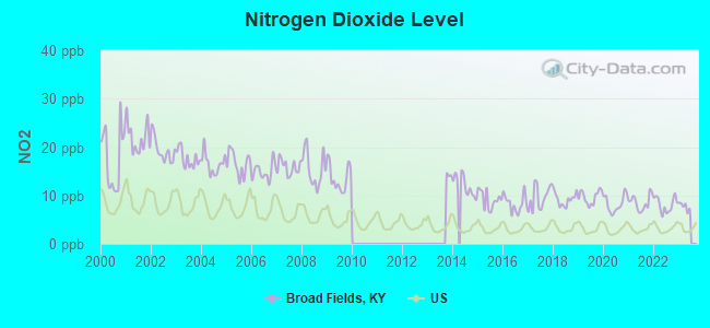
Nitrogen Dioxide (NO2) [ppb] level in 2022 was 8.10. This is significantly worse than average. Closest monitor was 0.9 miles away from the city center.
| City: | 8.10 |
| U.S.: | 5.11 |
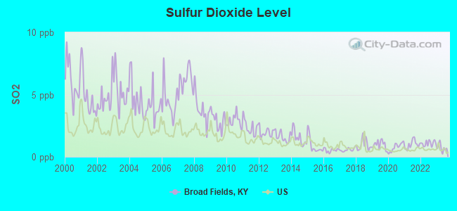
Sulfur Dioxide (SO2) [ppb] level in 2023 was 0.730. This is significantly better than average. Closest monitor was 0.9 miles away from the city center.
| City: | 0.730 |
| U.S.: | 1.515 |
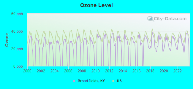
Ozone [ppb] level in 2023 was 32.3. This is about average. Closest monitor was 3.2 miles away from the city center.
| City: | 32.3 |
| U.S.: | 33.3 |
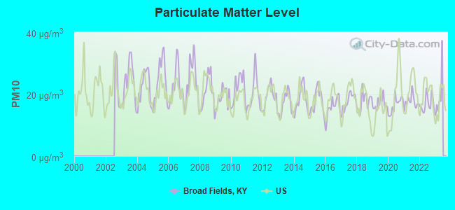
Particulate Matter (PM10) [µg/m3] level in 2022 was 16.9. This is about average. Closest monitor was 0.9 miles away from the city center.
| City: | 16.9 |
| U.S.: | 19.2 |
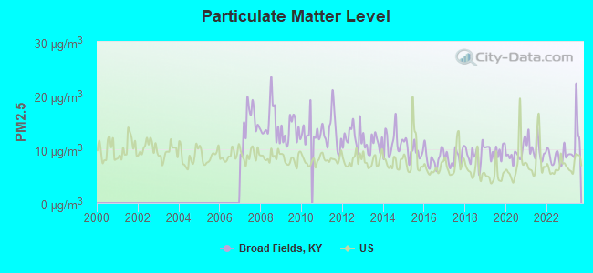
Particulate Matter (PM2.5) [µg/m3] level in 2023 was 11.4. This is significantly worse than average. Closest monitor was 0.9 miles away from the city center.
| City: | 11.4 |
| U.S.: | 8.1 |
Tornado activity:
Broad Fields-area historical tornado activity is slightly above Kentucky state average. It is 65% greater than the overall U.S. average.
On 4/3/1974, a category F4 (max. wind speeds 207-260 mph) tornado 6.0 miles away from the Broad Fields city center killed 3 people and injured 225 people.
On 4/3/1974, a category F5 (max. wind speeds 261-318 mph) tornado 27.0 miles away from the city center killed 6 people and injured 86 people and caused between $50,000,000 and $500,000,000 in damages.
Earthquake activity:
Broad Fields-area historical earthquake activity is significantly above Kentucky state average. It is 109% greater than the overall U.S. average.On 4/18/2008 at 09:36:59, a magnitude 5.4 (5.1 MB, 4.8 MS, 5.4 MW, 5.2 MW, Class: Moderate, Intensity: VI - VII) earthquake occurred 122.1 miles away from the city center
On 7/27/1980 at 18:52:21, a magnitude 5.2 (5.1 MB, 4.7 MS, 5.0 UK, 5.2 UK) earthquake occurred 92.9 miles away from Broad Fields center
On 4/18/2008 at 09:36:59, a magnitude 5.2 (5.2 MW, Depth: 8.9 mi) earthquake occurred 122.1 miles away from the city center
On 6/10/1987 at 23:48:54, a magnitude 5.1 (4.9 MB, 4.4 MS, 4.6 MS, 5.1 LG) earthquake occurred 127.3 miles away from Broad Fields center
On 6/18/2002 at 17:37:15, a magnitude 5.0 (4.3 MB, 4.6 MW, 5.0 LG) earthquake occurred 117.1 miles away from Broad Fields center
On 4/18/2008 at 15:14:16, a magnitude 4.8 (4.5 MB, 4.8 MW, 4.6 MW, Class: Light, Intensity: IV - V) earthquake occurred 120.2 miles away from Broad Fields center
Magnitude types: regional Lg-wave magnitude (LG), body-wave magnitude (MB), surface-wave magnitude (MS), moment magnitude (MW)
Natural disasters:
The number of natural disasters in Jefferson County (17) is near the US average (15).Major Disasters (Presidential) Declared: 13
Emergencies Declared: 2
Causes of natural disasters: Floods: 10, Storms: 10, Tornadoes: 6, Mudslides: 3, Landslides: 2, Winds: 2, Winter Storms: 2, Blizzard: 1, Explosion: 1, Hurricane: 1, Tropical Depression: 1, Other: 1 (Note: some incidents may be assigned to more than one category).
Hospitals and medical centers near Broad Fields:
- GOLDEN LIVINGCENTER - ST MATTHEWS (Nursing Home, about 1 miles away; LOUISVILLE, KY)
- BAPTIST HEALTH LOUISVILLE Acute Care Hospitals (about 1 miles away; LOUISVILLE, KY)
- MASONIC HOME OF LOUISVILLE (Nursing Home, about 2 miles away; MASONIC HOME, KY)
- FMC - SUBURBAN (Dialysis Facility, about 2 miles away; LOUISVILLE, KY)
- NORTON SUBURBAN HOSPITAL (Hospital, about 2 miles away; LOUISVILLE, KY)
- FMC - KENTUCKIANA HOME THERAPIES (Dialysis Facility, about 2 miles away; LOUISVILLE, KY)
- BAPTIST HOSPITAL EAST HOME HEALTH AGENCY (Home Health Center, about 2 miles away; LOUISVILLE, KY)
Colleges/universities with over 2000 students nearest to Broad Fields:
- The Southern Baptist Theological Seminary (about 3 miles; Louisville, KY; Full-time enrollment: 2,360)
- Sullivan University (about 3 miles; Louisville, KY; FT enrollment: 5,129)
- Bellarmine University (about 4 miles; Louisville, KY; FT enrollment: 3,180)
- Jefferson Community and Technical College (about 6 miles; Louisville, KY; FT enrollment: 7,950)
- University of Louisville (about 7 miles; Louisville, KY; FT enrollment: 16,640)
- Indiana University-Southeast (about 12 miles; New Albany, IN; FT enrollment: 5,050)
- Elizabethtown Community and Technical College (about 39 miles; Elizabethtown, KY; FT enrollment: 3,762)
Points of interest:
| This city: | 2.2 people |
| Kentucky: | 2.5 people |
| This city: | 67.0% |
| Whole state: | 69.8% |
| This city: | 2.6% |
| Whole state: | 4.5% |
Likely homosexual households (counted as self-reported same-sex unmarried-partner households)
- Lesbian couples: 0.0% of all households
- Gay men: 1.7% of all households
| This city: | 0.8% |
| Whole state: | 15.8% |
| This city: | 0.8% |
| Whole state: | 6.6% |
For population 15 years and over in Broad Fields:
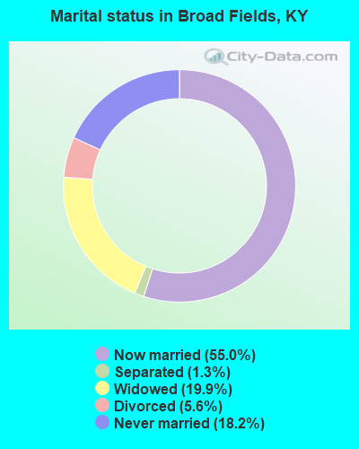
- Never married: 18.2%
- Now married: 55.0%
- Separated: 1.3%
- Widowed: 19.9%
- Divorced: 5.6%
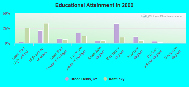
For population 25 years and over in Broad Fields:
- High school or higher: 98.1%
- Bachelor's degree or higher: 47.4%
- Graduate or professional degree: 14.4%
- Mean travel time to work (commute): 17.2 minutes
| Here: | 8.5 |
| Kentucky average: | 13.8 |
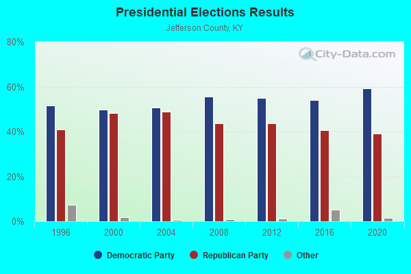
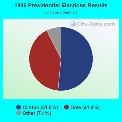
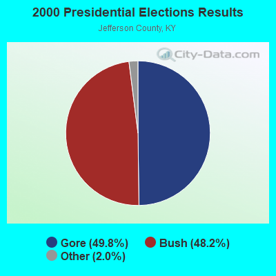
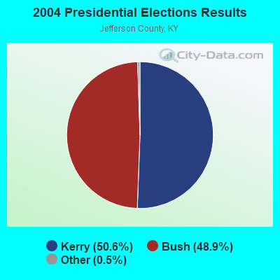

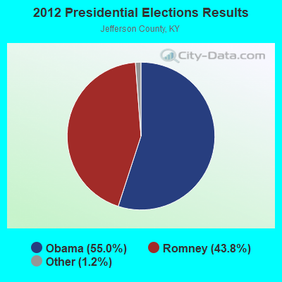
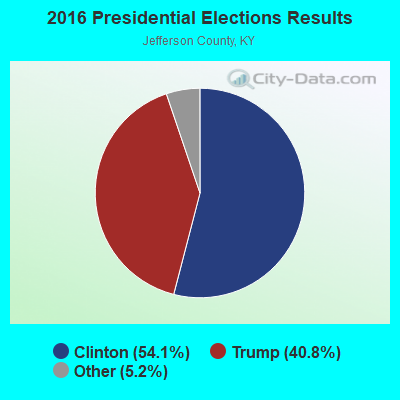

Graphs represent county-level data. Detailed 2008 Election Results
Religion statistics for Broad Fields, KY (based on Jefferson County data)
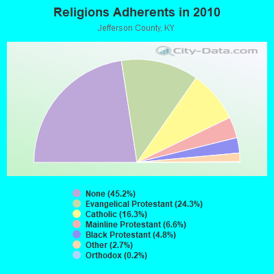
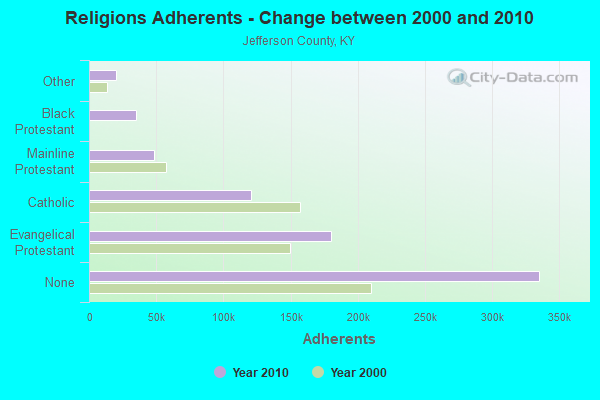
| Religion | Adherents | Congregations |
|---|---|---|
| Evangelical Protestant | 180,149 | 384 |
| Catholic | 120,620 | 60 |
| Mainline Protestant | 48,598 | 129 |
| Black Protestant | 35,305 | 70 |
| Other | 19,947 | 58 |
| Orthodox | 1,180 | 3 |
| None | 335,297 | - |
Food Environment Statistics:
| Jefferson County: | 1.79 / 10,000 pop. |
| State: | 2.19 / 10,000 pop. |
| Jefferson County: | 0.16 / 10,000 pop. |
| Kentucky: | 0.25 / 10,000 pop. |
| Jefferson County: | 0.71 / 10,000 pop. |
| Kentucky: | 0.74 / 10,000 pop. |
| Jefferson County: | 2.75 / 10,000 pop. |
| Kentucky: | 4.36 / 10,000 pop. |
| Jefferson County: | 6.86 / 10,000 pop. |
| Kentucky: | 5.74 / 10,000 pop. |
| Jefferson County: | 10.6% |
| Kentucky: | 11.0% |
| Jefferson County: | 27.6% |
| Kentucky: | 30.0% |
| Jefferson County: | 13.4% |
| State: | 15.9% |
5.00% of this county's 2021 resident taxpayers lived in other counties in 2020 ($58,554 average adjusted gross income)
| Here: | 5.00% |
| Kentucky average: | 7.04% |
0.01% of residents moved from foreign countries ($178 average AGI)
Jefferson County: 0.01% Kentucky average: 0.02%
Top counties from which taxpayers relocated into this county between 2020 and 2021:
| from Bullitt County, KY | |
| from Clark County, IN | |
| from Oldham County, KY |
5.72% of this county's 2020 resident taxpayers moved to other counties in 2021 ($72,642 average adjusted gross income)
| Here: | 5.72% |
| Kentucky average: | 6.89% |
0.01% of residents moved to foreign countries ($55 average AGI)
Jefferson County: 0.01% Kentucky average: 0.01%
Top counties to which taxpayers relocated from this county between 2020 and 2021:
| to Bullitt County, KY | |
| to Clark County, IN | |
| to Oldham County, KY |
Strongest AM radio stations in Broad Fields:
- WHAS (840 AM; 50 kW; LOUISVILLE, KY; Owner: CLEAR CHANNEL BROADCASTING LICENSES, INC.)
- WXXA (790 AM; 5 kW; LOUISVILLE, KY)
- WGTK (970 AM; 5 kW; LOUISVILLE, KY; Owner: SALEM MEDIA OF KENTUCKY, INC.)
- WLLV (1240 AM; 1 kW; LOUISVILLE, KY; Owner: MORTENSON BROADCASTING COMPANY)
- WFIA (900 AM; 1 kW; LOUISVILLE, KY; Owner: SCA LICENSE CORPORATION)
- WKJK (1080 AM; 10 kW; LOUISVILLE, KY; Owner: CLEAR CHANNEL BROADCASTING LICENSES, INC.)
- WTMT (620 AM; 0 kW; LOUISVILLE, KY; Owner: JEFFERSON B/CASTING CMPANY, INC.)
- WLOU (1350 AM; 2 kW; LOUISVILLE, KY; Owner: MORTENSON BROADCASTING CO., INC.)
- WAVG (1450 AM; 1 kW; JEFFERSONVILLE, IN; Owner: SUNNYSIDE COMMUNICATIONS, INC)
- WDRD (680 AM; 1 kW; NEWBURG, KY; Owner: ABC, INC.)
- WXLN (1570 AM; 2 kW; NEW ALBANY, IN; Owner: MORTENSON BROADCASTING COMPANY)
- WLW (700 AM; 50 kW; CINCINNATI, OH; Owner: JACOR BROADCASTING CORPORATION)
- WSAI (1530 AM; 50 kW; CINCINNATI, OH; Owner: JACOR BROADCASTING CORPORATION)
Strongest FM radio stations in Broad Fields:
- WMJM (101.3 FM; JEFFERSONTOWN, KY; Owner: BLUE CHIP BROADCASTING LICENSES II, LTD.)
- WFPL (89.3 FM; LOUISVILLE, KY; Owner: KENTUCKY PUBLIC RADIO, INC.)
- WRKA (103.1 FM; ST. MATTHEWS, KY; Owner: CXR HOLDINGS, INC.)
- WPTI (103.9 FM; LOUISVILLE, KY; Owner: CXR HOLDINGS, INC.)
- WTFX-FM (100.5 FM; LOUISVILLE, KY; Owner: CLEAR CHANNEL BROADCASTING LICENSES, INC.)
- WXMA (102.3 FM; LOUISVILLE, KY; Owner: BLUE CHIP BROADCASTING LICENSES II, LTD.)
- WFPK (91.9 FM; LOUISVILLE, KY; Owner: KENTUCKY PUBLIC RADIO, INC.)
- WUOL-FM (90.5 FM; LOUISVILLE, KY; Owner: KENTUCKY PUBLIC RADIO, INC.)
- WDJX (99.7 FM; LOUISVILLE, KY; Owner: BLUE CHIP BROADCASTING LICENSES II, LTD.)
- WAMZ (97.5 FM; LOUISVILLE, KY; Owner: CLEAR CHANNEL BROADCASTING LICENSES, INC.)
- WVEZ (106.9 FM; LOUISVILLE, KY; Owner: CXR HOLDINGS, INC.)
- WRVI (105.9 FM; VALLEY STATION, KY; Owner: SALEM MEDIA OF KENTUCKY, INC.)
- WJIE-FM (88.5 FM; OKOLONA, KY; Owner: EVANGEL SCHOOLS, INC.)
- WSFR (107.7 FM; CORYDON, IN; Owner: CXR HOLDINGS, INC.)
- WQMF (95.7 FM; JEFFERSONVILLE, IN; Owner: CLEAR CHANNEL BROADCASTING LICENSES, INC.)
- W284AD (104.7 FM; NEW ALBANY, IN; Owner: LIFETALK RADIO, INC.)
- WLRS (105.1 FM; SHEPHERDSVILLE, KY; Owner: BLUE CHIP BROADCASTING LICENSES II, LTD.)
- WFIA-FM (94.7 FM; NEW ALBANY, IN; Owner: SALEM MEDIA OF KENTUCKY, INC.)
- WJZL (93.1 FM; CLARKSVILLE, IN; Owner: CLEAR CHANNEL BROADCASTING LICENSES, INC.)
- WZKF (98.9 FM; SALEM, IN; Owner: CLEAR CHANNEL BROADCASTING LICENSES, INC.)
TV broadcast stations around Broad Fields:
- W24BW (Channel 24; LOUISVILLE, KY; Owner: GREATER LOUISVILLE COMMUNICATIONS)
- WVHF-LP (Channel 5; JEFFERSONVILLE, ETC., IN; Owner: JOHN W. SMITH, JR.)
- WBXV-CA (Channel 13; LOUISVILLE, KY; Owner: THE BOX WORLDWIDE LLC)
- WAVE (Channel 3; LOUISVILLE, KY; Owner: LIBCO, INC.)
- WHAS-TV (Channel 11; LOUISVILLE, KY; Owner: BELO KENTUCKY, INC.)
- WBKI-CA (Channel 28; LOUISVILLE, KY; Owner: LOUISVILLE COMMUNICATIONS, LLC)
- WDRB (Channel 41; LOUISVILLE, KY; Owner: INDEPENDENCE TELEVISION COMPANY)
- WFTE (Channel 58; SALEM, IN; Owner: INDEPENDENCE TELEVISION COMPANY)
- WLKY-TV (Channel 32; LOUISVILLE, KY; Owner: WLKY HEARST-ARGYLE TELEVISION, INC.)
- WJYL-CA (Channel 45; CLARKSVILLE, IN; Owner: JOHN W. SMITH, JR.)
- WKPC-TV (Channel 15; LOUISVILLE, KY; Owner: KENTUCKY AUTHORITY FOR EDUC'L. TV)
- WKMJ-TV (Channel 68; LOUISVILLE, KY; Owner: KENTUCKY AUTHORITY FOR EDUCATIONAL TV)
- WBNA (Channel 21; LOUISVILLE, KY; Owner: WORD BROADCASTING NETWORK, INC.)
- W50CI (Channel 50; LOUISVILLE, KY; Owner: SOUTH CENTRAL COMMUNICATIONS CORP.)
| Home Mortgage Disclosure Act Aggregated Statistics For Year 2009 (Based on 1 partial tract) | ||||||
| A) FHA, FSA/RHS & VA Home Purchase Loans | B) Conventional Home Purchase Loans | C) Refinancings | ||||
|---|---|---|---|---|---|---|
| Number | Average Value | Number | Average Value | Number | Average Value | |
| LOANS ORIGINATED | 1 | $90,270 | 1 | $218,790 | 6 | $175,678 |
| APPLICATIONS APPROVED, NOT ACCEPTED | 0 | $0 | 0 | $0 | 0 | $0 |
| APPLICATIONS DENIED | 0 | $0 | 0 | $0 | 1 | $210,970 |
| APPLICATIONS WITHDRAWN | 0 | $0 | 0 | $0 | 1 | $194,140 |
| FILES CLOSED FOR INCOMPLETENESS | 0 | $0 | 0 | $0 | 1 | $158,610 |
Detailed HMDA statistics for the following Tracts: 0105.00
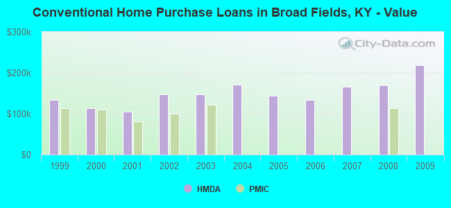
| Private Mortgage Insurance Companies Aggregated Statistics For Year 2008 (Based on 1 partial tract) | ||
| A) Conventional Home Purchase Loans | ||
|---|---|---|
| Number | Average Value | |
| LOANS ORIGINATED | 1 | $113,150 |
| APPLICATIONS APPROVED, NOT ACCEPTED | 0 | $0 |
| APPLICATIONS DENIED | 0 | $0 |
| APPLICATIONS WITHDRAWN | 0 | $0 |
| FILES CLOSED FOR INCOMPLETENESS | 0 | $0 |
Detailed PMIC statistics for the following Tracts: 0105.00
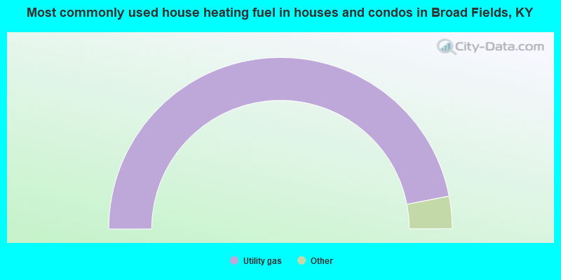
- 93.9%Utility gas
- 3.5%Electricity
- 2.6%Bottled, tank, or LP gas
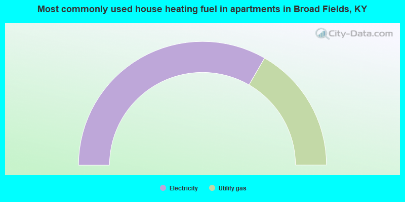
- 66.7%Electricity
- 33.3%Utility gas
Broad Fields compared to Kentucky state average:
- Median household income above state average.
- Median house value above state average.
- Unemployed percentage significantly below state average.
- Black race population percentage significantly below state average.
- Hispanic race population percentage significantly below state average.
- Median age significantly above state average.
- Foreign-born population percentage significantly below state average.
- Renting percentage significantly below state average.
- Length of stay since moving in significantly above state average.
- Number of rooms per house significantly below state average.
- House age significantly below state average.
- Number of college students below state average.
- Percentage of population with a bachelor's degree or higher significantly above state average.