Brookfield, Massachusetts
Submit your own pictures of this town and show them to the world
- OSM Map
- General Map
- Google Map
- MSN Map

Population change since 2000: +11.1%
 |
| Males: 1,679 | |
| Females: 1,711 |
| Median resident age: | 43.6 years |
| Massachusetts median age: | 39.2 years |
Zip codes: 01506.
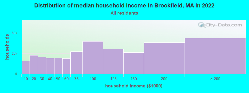
| Brookfield: | $82,260 |
| MA: | $94,488 |
Estimated per capita income in 2022: $39,277 (it was $20,144 in 2000)
Brookfield town income, earnings, and wages data
Estimated median house or condo value in 2022: $327,522 (it was $118,600 in 2000)
| Brookfield: | $327,522 |
| MA: | $534,700 |
Mean prices in 2022: all housing units: $419,164; detached houses: $447,621; townhouses or other attached units: $343,592; in 2-unit structures: $323,295; in 3-to-4-unit structures: $332,295; in 5-or-more-unit structures: $232,758; mobile homes: $113,885
Detailed information about poverty and poor residents in Brookfield, MA
Compare current foreclosures near Brookfield, MA:
| Photo | Address | Area | Beds / Baths | Price | Details |
|---|---|---|---|---|---|

|
#1
Webber Rd
Brookfield, MA 01506
|
960 sq. feet
|
1 baths 3 beds |
show details | |

|
#2
Lake View Ave
Brookfield, MA 01506
|
1,200 sq. feet
|
1 baths 3 beds |
show details | |

|
#3
Oak Ave
Brookfield, MA 01506
|
1,200 sq. feet
|
1 baths 2 beds |
show details | |

|
#4
Lake View Ave
Brookfield, MA 01506
|
1,200 sq. feet
|
1 baths 3 beds |
show details | |

|
#5
Webber Rd
Brookfield, MA 01506
|
960 sq. feet
|
1 baths 3 beds |
show details | |

|
#6
Fiskdale Rd
Brookfield, MA 01506
|
1,664 sq. feet
|
2 baths 3 beds |
show details | |

|
#7
Molasses Hill Rd
Brookfield, MA 01506
|
- sq. feet
|
- baths - beds |
show details | |

|
#8
N Brookfield Rd
Oakham, MA 01068
|
1,078 sq. feet
|
1 baths 2 beds |
$459,900
|
show details |

|
#9
State St
Bondsville, MA 01009
|
1,381 sq. feet
|
1 baths 3 beds |
$135,000
|
show details |

|
#10
Hardwick Road
Hardwick, MA 01037
|
- sq. feet
|
1 baths 3 beds |
$244,900
|
show details |
| Photo | Address | Area | Beds / Baths | Price | Details |
|---|---|---|---|---|---|

|
#11
Main St # 3144
Palmer, MA 01069
|
875 sq. feet
|
1 baths 2 beds |
show details | |

|
#12
Paine District Rd
Woodstock, CT 06281
|
1,092 sq. feet
|
1 baths 2 beds |
show details | |

|
#13
Colburn Rd
Stafford Springs, CT 06076
|
1,114 sq. feet
|
1 baths 2 beds |
show details | |

|
#14
Chestnut St
Spencer, MA 01562
|
1,078 sq. feet
|
1 baths 3 beds |
show details | |

|
#15
Amber Rd
Holland, MA 01521
|
1,363 sq. feet
|
1 baths 3 beds |
show details | |

|
#16
South Street
Ware, MA 01082
|
2,145 sq. feet
|
2 baths 4 beds |
show details | |

|
#17
Lakeview Dr
Charlton, MA 01507
|
1,235 sq. feet
|
1 baths 3 beds |
show details | |

|
#18
W Lake St
Worcester, MA 01603
|
3,266 sq. feet
|
2 baths 5 beds |
show details | |

|
#19
Brookfield Rd
Brimfield, MA 01010
|
1,482 sq. feet
|
3 baths 3 beds |
show details | |

|
#20
Grizzly Dr
Rutland, MA 01543
|
- sq. feet
|
2 baths 3 beds |
show details |
| Photo | Address | Area | Beds / Baths | Price | Details |
|---|---|---|---|---|---|

|
#21
Marc Ave
Southbridge, MA 01550
|
960 sq. feet
|
1 baths 3 beds |
show details | |

|
#22
Stafford Rd
Monson, MA 01057
|
1,464 sq. feet
|
1 baths 3 beds |
show details | |

|
#23
Treadwell Ter
Spencer, MA 01562
|
960 sq. feet
|
1 baths 3 beds |
show details | |

|
#24
Reed St
Warren, MA 01083
|
1,152 sq. feet
|
2 baths 3 beds |
show details | |

|
#25
Leicester St
Auburn, MA 01501
|
912 sq. feet
|
1 baths 2 beds |
show details | |

|
#26
Main St
Palmer, MA 01069
|
1,114 sq. feet
|
2 baths 3 beds |
show details | |

|
#27
Englewood Ave
Worcester, MA 01603
|
2,730 sq. feet
|
1 baths 6 beds |
show details | |

|
#28
Dudley Rd
Oxford, MA 01540
|
1,050 sq. feet
|
1 baths 2 beds |
show details | |

|
#29
Dawson Rd
Worcester, MA 01602
|
1,178 sq. feet
|
1 baths 2 beds |
show details | |

|
#30
Dudley Rd
Oxford, MA 01540
|
1,050 sq. feet
|
1 baths 2 beds |
show details |
| Photo | Address | Area | Beds / Baths | Price | Details |
|---|---|---|---|---|---|

|
#31
Main St
Oxford, MA 01540
|
3,244 sq. feet
|
2 baths 7 beds |
show details | |

|
#32
Oxford St N
Auburn, MA 01501
|
897 sq. feet
|
1 baths 2 beds |
show details | |

|
#33
Pineview Trl
Auburn, MA 01501
|
791 sq. feet
|
1 baths 4 beds |
show details | |

|
#34
Ravine Dr
Auburn, MA 01501
|
872 sq. feet
|
1 baths 2 beds |
show details | |

|
#35
Federal Hill Rd
Oxford, MA 01540
|
1,800 sq. feet
|
1 baths 3 beds |
show details | |

|
#36
Pinewood Ln
Worcester, MA 01609
|
1,208 sq. feet
|
2 baths 3 beds |
show details | |

|
#37
Old Millbury Rd
Oxford, MA 01540
|
1,736 sq. feet
|
2 baths 3 beds |
show details | |

|
#38
Ashmore Rd
Worcester, MA 01602
|
2,046 sq. feet
|
1 baths 3 beds |
show details | |

|
#39
Beaconsfield Rd
Worcester, MA 01602
|
1,668 sq. feet
|
1 baths 3 beds |
show details | |

|
#40
Fenton Dr
Worcester, MA 01602
|
1,540 sq. feet
|
1 baths 3 beds |
show details |
| Photo | Address | Area | Beds / Baths | Price | Details |
|---|---|---|---|---|---|

|
#41
Faneuf St
Auburn, MA 01501
|
1,116 sq. feet
|
1 baths 3 beds |
show details | |

|
#42
Healy Rd
Worcester, MA 01603
|
971 sq. feet
|
1 baths 2 beds |
show details | |

|
#43
Baker St
Worcester, MA 01603
|
1,879 sq. feet
|
2 baths 4 beds |
show details | |

|
#44
Westwood Dr
Auburn, MA 01501
|
1,078 sq. feet
|
1 baths 3 beds |
show details | |

|
#45
Rawson Rd
Woodstock, CT 06281
|
2,556 sq. feet
|
2 baths 3 beds |
show details | |

|
#46
Main St # 1
Oxford, MA 01540
|
1,199 sq. feet
|
2 baths 3 beds |
show details | |

|
#47
Minthorne St
Worcester, MA 01603
|
2,345 sq. feet
|
1 baths 4 beds |
show details | |

|
#48
Vesper St
Worcester, MA 01602
|
2,128 sq. feet
|
2 baths 6 beds |
show details | |

|
#49
Lovett Rd
Oxford, MA 01540
|
1,696 sq. feet
|
2 baths 3 beds |
show details | |

|
Check over 1 million property listings on Foreclosure.com!
|
browse all offers | |||


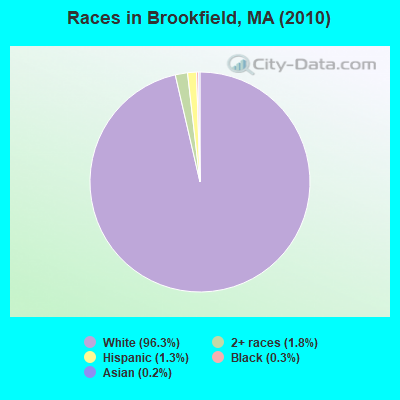
- 3,26596.3%White alone
- 611.8%Two or more races
- 441.3%Hispanic
- 100.3%Black alone
- 70.2%Asian alone
- 30.09%American Indian alone
Races in Brookfield detailed stats: ancestries, foreign born residents, place of birth
According to our research of Massachusetts and other state lists, there were 4 registered sex offenders living in Brookfield, Massachusetts as of April 25, 2024.
The ratio of all residents to sex offenders in Brookfield is 848 to 1.
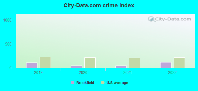
Type |
2019 |
2020 |
2021 |
2022 |
|---|---|---|---|---|
| Murders (per 100,000) | 0 (0.0) | 0 (0.0) | 0 (0.0) | 0 (0.0) |
| Rapes (per 100,000) | 2 (58.1) | 1 (29.1) | 0 (0.0) | 3 (87.1) |
| Robberies (per 100,000) | 1 (29.1) | 0 (0.0) | 0 (0.0) | 0 (0.0) |
| Assaults (per 100,000) | 3 (87.2) | 1 (29.1) | 5 (144.0) | 3 (87.1) |
| Burglaries (per 100,000) | 4 (116.3) | 5 (145.3) | 0 (0.0) | 2 (58.1) |
| Thefts (per 100,000) | 20 (581.4) | 3 (87.2) | 9 (259.1) | 8 (232.4) |
| Auto thefts (per 100,000) | 2 (58.1) | 2 (58.1) | 2 (57.6) | 5 (145.2) |
| Arson (per 100,000) | 0 (0.0) | 0 (0.0) | 1 (28.8) | 0 (0.0) |
| City-Data.com crime index | 108.7 | 47.4 | 43.8 | 112.1 |
The City-Data.com crime index weighs serious crimes and violent crimes more heavily. Higher means more crime, U.S. average is 246.1. It adjusts for the number of visitors and daily workers commuting into cities.
Crime rate in Brookfield detailed stats: murders, rapes, robberies, assaults, burglaries, thefts, arson
Full-time law enforcement employees in 2021, including police officers: 5 (5 officers - 4 male; 1 female).
| Officers per 1,000 residents here: | 1.44 |
| Massachusetts average: | 2.53 |
 Recent articles from our blog. Our writers, many of them Ph.D. graduates or candidates, create easy-to-read articles on a wide variety of topics.


 | What is living in North Brookfield like? (6 replies) |
| 2023 Real Estate Observations (5278 replies) |
| Population slightly down in MA 2022 (362 replies) |
| Big MA Ancestry Data Thread by Town (31 replies) |
| Central or Western MA towns for Seniors (16 replies) |
| Massachusetts has many "best small cities in America" (25 replies) |
Latest news from Brookfield, MA collected exclusively by city-data.com from local newspapers, TV, and radio stations
Ancestries: French (23.4%), English (17.2%), Irish (16.8%), French Canadian (14.4%), Polish (8.4%), Italian (7.6%).
Current Local Time: EST time zone
Incorporated in 1718
Elevation: 714 feet
Land area: 15.5 square miles.
Population density: 218 people per square mile (very low).
43 residents are foreign born
| This town: | 1.4% |
| Massachusetts: | 12.2% |
| Brookfield town: | 1.5% ($1,803) |
| Massachusetts: | 1.3% ($2,336) |
Nearest city with pop. 50,000+: Worcester, MA  (15.8 miles , pop. 172,648).
Nearest city with pop. 200,000+: Boston, MA (52.3 miles , pop. 589,141).
Nearest city with pop. 1,000,000+: Bronx, NY (131.2 miles , pop. 1,332,650).
Nearest cities:
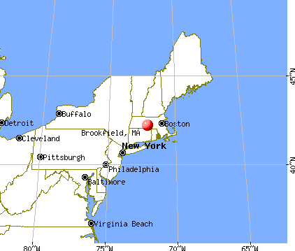
), ), Latitude: 42.20 N, Longitude: 72.10 W

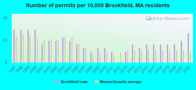
Single-family new house construction building permits:
- 2022: 8 buildings, average cost: $46,700
- 2021: 6 buildings, average cost: $46,700
- 2020: 5 buildings, average cost: $265,300
- 2019: 5 buildings, average cost: $115,300
- 2018: 5 buildings, average cost: $115,300
- 2017: 5 buildings, average cost: $115,300
- 2016: 5 buildings, average cost: $115,300
- 2015: 4 buildings, average cost: $115,300
- 2014: 5 buildings, average cost: $115,300
- 2013: 3 buildings, average cost: $52,500
- 2011: 3 buildings, average cost: $128,900
- 2010: 4 buildings, average cost: $128,900
- 2009: 4 buildings, average cost: $128,900
- 2008: 3 buildings, average cost: $128,900
- 2007: 4 buildings, average cost: $128,900
- 2006: 5 buildings, average cost: $128,900
- 2005: 6 buildings, average cost: $128,900
- 2004: 7 buildings, average cost: $128,900
- 2003: 6 buildings, average cost: $128,900
- 2002: 6 buildings, average cost: $128,900
- 2001: 5 buildings, average cost: $128,900
- 2000: 9 buildings, average cost: $128,900
- 1999: 9 buildings, average cost: $128,900
- 1998: 9 buildings, average cost: $129,000
- 1997: 9 buildings, average cost: $128,200

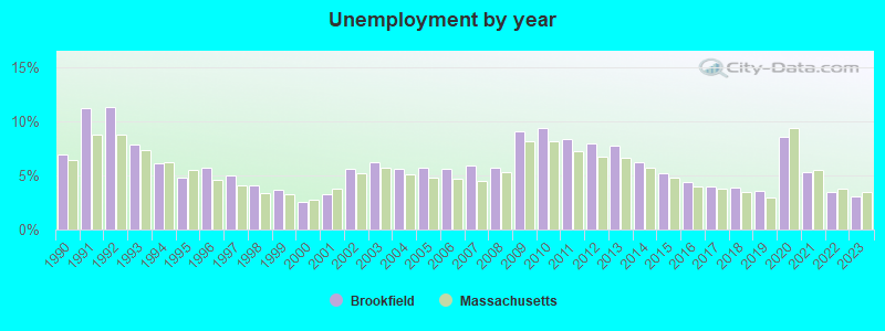
| Here: | 3.1% |
| Massachusetts: | 3.5% |


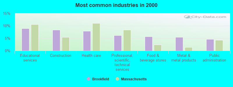
- Educational services (9.0%)
- Construction (8.4%)
- Health care (8.0%)
- Professional, scientific, technical services (6.1%)
- Food & beverage stores (5.7%)
- Metal & metal products (5.5%)
- Public administration (4.6%)
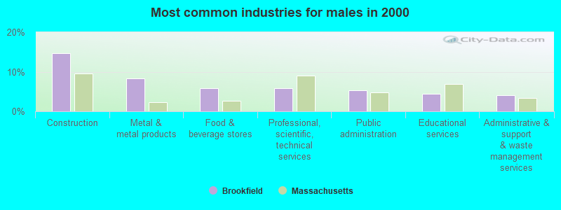
- Construction (14.8%)
- Metal & metal products (8.4%)
- Food & beverage stores (5.9%)
- Professional, scientific, technical services (5.8%)
- Public administration (5.3%)
- Educational services (4.4%)
- Administrative & support & waste management services (4.1%)
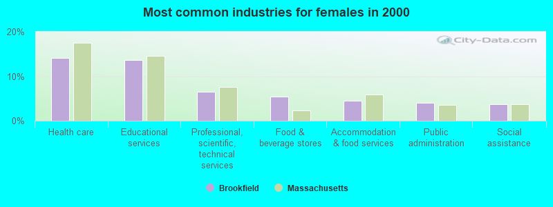
- Health care (14.0%)
- Educational services (13.7%)
- Professional, scientific, technical services (6.5%)
- Food & beverage stores (5.5%)
- Accommodation & food services (4.5%)
- Public administration (4.0%)
- Social assistance (3.7%)
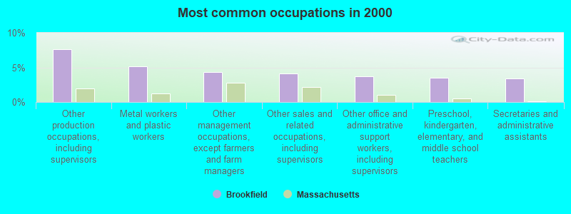
- Other production occupations, including supervisors (7.6%)
- Metal workers and plastic workers (5.2%)
- Other management occupations, except farmers and farm managers (4.3%)
- Other sales and related occupations, including supervisors (4.1%)
- Other office and administrative support workers, including supervisors (3.7%)
- Preschool, kindergarten, elementary, and middle school teachers (3.5%)
- Secretaries and administrative assistants (3.4%)

- Other production occupations, including supervisors (10.7%)
- Metal workers and plastic workers (8.6%)
- Driver/sales workers and truck drivers (5.3%)
- Building and grounds cleaning and maintenance occupations (4.6%)
- Electrical equipment mechanics and other installation, maintenance, and repair workers, including supervisors (4.4%)
- Other sales and related occupations, including supervisors (3.8%)
- Material recording, scheduling, dispatching, and distributing workers (3.7%)
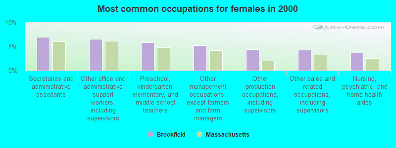
- Secretaries and administrative assistants (7.0%)
- Other office and administrative support workers, including supervisors (6.6%)
- Preschool, kindergarten, elementary, and middle school teachers (5.9%)
- Other management occupations, except farmers and farm managers (5.2%)
- Other production occupations, including supervisors (4.5%)
- Other sales and related occupations, including supervisors (4.3%)
- Nursing, psychiatric, and home health aides (3.7%)
Average climate in Brookfield, Massachusetts
Based on data reported by over 4,000 weather stations


(lower is better)
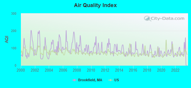
Air Quality Index (AQI) level in 2022 was 71.6. This is about average.
| City: | 71.6 |
| U.S.: | 72.6 |

Carbon Monoxide (CO) [ppm] level in 2022 was 0.259. This is about average. Closest monitor was 15.8 miles away from the city center.
| City: | 0.259 |
| U.S.: | 0.251 |
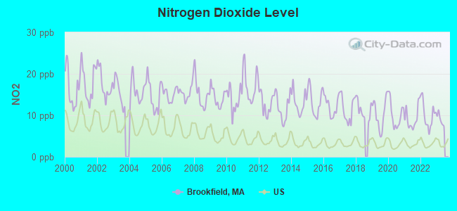
Nitrogen Dioxide (NO2) [ppb] level in 2022 was 10.1. This is significantly worse than average. Closest monitor was 14.4 miles away from the city center.
| City: | 10.1 |
| U.S.: | 5.1 |
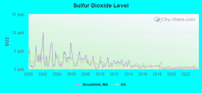
Sulfur Dioxide (SO2) [ppb] level in 2022 was 0.282. This is significantly better than average. Closest monitor was 13.9 miles away from the city center.
| City: | 0.282 |
| U.S.: | 1.515 |
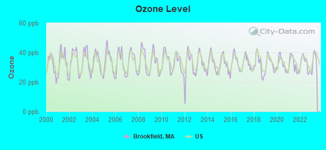
Ozone [ppb] level in 2022 was 32.3. This is about average. Closest monitor was 9.9 miles away from the city center.
| City: | 32.3 |
| U.S.: | 33.3 |
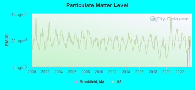
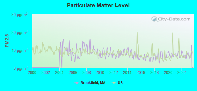
Particulate Matter (PM2.5) [µg/m3] level in 2022 was 7.27. This is about average. Closest monitor was 13.9 miles away from the city center.
| City: | 7.27 |
| U.S.: | 8.11 |
Tornado activity:
Brookfield-area historical tornado activity is above Massachusetts state average. It is 14% smaller than the overall U.S. average.
On 6/9/1953, a category F4 (max. wind speeds 207-260 mph) tornado 19.0 miles away from the Brookfield town center killed 90 people and injured 1228 people and caused between $50,000,000 and $500,000,000 in damages.
On 10/3/1979, a category F4 tornado 32.6 miles away from the town center killed 3 people and injured 500 people and caused between $50,000,000 and $500,000,000 in damages.
Earthquake activity:
Brookfield-area historical earthquake activity is significantly above Massachusetts state average. It is 71% smaller than the overall U.S. average.On 10/7/1983 at 10:18:46, a magnitude 5.3 (5.1 MB, 5.3 LG, 5.1 ML, Class: Moderate, Intensity: VI - VII) earthquake occurred 166.0 miles away from the city center
On 4/20/2002 at 10:50:47, a magnitude 5.3 (5.3 ML, Depth: 3.0 mi) earthquake occurred 179.0 miles away from Brookfield center
On 4/20/2002 at 10:50:47, a magnitude 5.2 (5.2 MB, 4.2 MS, 5.2 MW, 5.0 MW) earthquake occurred 177.9 miles away from the city center
On 1/19/1982 at 00:14:42, a magnitude 4.7 (4.5 MB, 4.7 MD, 4.5 LG, Class: Light, Intensity: IV - V) earthquake occurred 93.4 miles away from the city center
On 10/16/2012 at 23:12:25, a magnitude 4.7 (4.7 ML, Depth: 10.0 mi) earthquake occurred 121.1 miles away from Brookfield center
On 10/2/1994 at 11:27:22, a magnitude 3.7 (3.5 LG, 3.7 LG, Depth: 6.2 mi, Class: Light, Intensity: II - III) earthquake occurred 13.7 miles away from Brookfield center
Magnitude types: regional Lg-wave magnitude (LG), body-wave magnitude (MB), duration magnitude (MD), local magnitude (ML), surface-wave magnitude (MS), moment magnitude (MW)
Natural disasters:
The number of natural disasters in Worcester County (27) is a lot greater than the US average (15).Major Disasters (Presidential) Declared: 15
Emergencies Declared: 12
Causes of natural disasters: Floods: 9, Storms: 8, Hurricanes: 6, Snowstorms: 5, Winter Storms: 4, Blizzards: 2, Snows: 2, Fire: 1, Heavy Rain: 1, Snowfall: 1, Tornado: 1, Wind: 1 (Note: some incidents may be assigned to more than one category).
Hospitals and medical centers near Brookfield:
- GUARDIAN HOSPICE OF MASSACHUSETTS, INC (Hospital, about 4 miles away; WEST BROOKFIELD, MA)
- QUABOAG REHABILITATION AND SKILLED CARE CENTER (Nursing Home, about 4 miles away; WEST BROOKFIELD, MA)
- FAMILY HOME CARE, INC (Home Health Center, about 7 miles away; SPENCER, MA)
- OVERLOOK VNA AND HOSPICE SERVICES (Hospital, about 8 miles away; CHARLTON, MA)
- BAYSTATE MARY LANE HOSPITAL Acute Care Hospitals (about 9 miles away; WARE, MA)
- HARRINGTON MEMORIAL HOSPITAL Acute Care Hospitals (about 9 miles away; SOUTHBRIDGE, MA)
- LIBERTY HOUSE (Nursing Home, about 10 miles away; SOUTHBRIDGE, MA)
Amtrak station near Brookfield:
Colleges/universities with over 2000 students nearest to Brookfield:
- Worcester State University (about 14 miles; Worcester, MA; Full-time enrollment: 5,426)
- Clark University (about 15 miles; Worcester, MA; FT enrollment: 3,687)
- College of the Holy Cross (about 16 miles; Worcester, MA; FT enrollment: 3,125)
- Assumption College (about 16 miles; Worcester, MA; FT enrollment: 2,580)
- Worcester Polytechnic Institute (about 16 miles; Worcester, MA; FT enrollment: 3,930)
- Quinsigamond Community College (about 18 miles; Worcester, MA; FT enrollment: 5,877)
- Western New England University (about 23 miles; Springfield, MA; FT enrollment: 3,477)
Public elementary/middle school in Brookfield:
- BROOKFIELD ELEMENTARY (Students: 277, Location: 37 CENTRAL STREET, Grades: PK-6)
Points of interest:
Notable locations in Brookfield: Brookfield Fire Department (A), Brookfield Town Hall (B). Display/hide their locations on the map
Churches in Brookfield include: Saint Marys Church (A), Brookfield Congregational Church (B). Display/hide their locations on the map
Cemetery: Brookfield Cemetery (1). Display/hide its location on the map
Parks in Brookfield include: Brookfield Common Historic District (1), Mall Common (2). Display/hide their locations on the map
Court: Massachusetts Commonwealth - Trial Court- East Brookfield District Court- Judges L (544 East Main).
Birthplace of: Theodore Foster - Politician, Dwight Foster (1757–1823) - Politician, William Appleton (politician) - Politician, Edward Gardiner Howe - Educator, James Reed (soldier) - General, Philip Henry Savage - Poet, Tom Niland - Baseball player.
Drinking water stations with addresses in Brookfield and their reported violations in the past:
BROOKFIELD WATER DEPARTMENT (Population served: 1,138, Groundwater):Past health violations:WAGON WHEEL COMMUNITY, INC. (Population served: 228, Groundwater):Past monitoring violations:
- MCL, Monthly (TCR) - In MAY-2005, Contaminant: Coliform. Follow-up actions: St Compliance achieved (JUN-16-2005), St AO (w/o penalty) issued (JUN-16-2005)
- One minor monitoring violation
Past health violations:NANATOMQUA MOBILE HOME PARK (Population served: 123, Groundwater):Past monitoring violations:
- MCL, Monthly (TCR) - In DEC-2010, Contaminant: Coliform. Follow-up actions: St AO (w/o penalty) issued (FEB-04-2011), St Compliance achieved (AUG-10-2011)
- MCL, Monthly (TCR) - In NOV-2010, Contaminant: Coliform. Follow-up actions: St AO (w/o penalty) issued (FEB-04-2011), St Compliance achieved (AUG-10-2011)
- MCL, Monthly (TCR) - In AUG-2010, Contaminant: Coliform. Follow-up actions: St AO (w/o penalty) issued (SEP-08-2010), St Compliance achieved (SEP-08-2010)
- MCL, Monthly (TCR) - In JUL-2010, Contaminant: Coliform. Follow-up actions: St AO (w/o penalty) issued (SEP-20-2010), St Compliance achieved (SEP-20-2010)
- 5 routine major monitoring violations
- 3 minor monitoring violations
Past health violations:BROOKFIELD MEADOWS MHP (Population served: 120, Groundwater):Past monitoring violations:
- MCL, Monthly (TCR) - In FEB-2013, Contaminant: Coliform. Follow-up actions: St AO (w/o penalty) issued (APR-01-2013)
- 6 minor monitoring violations
- 54 regular monitoring violations
Past health violations:Past monitoring violations:
- MCL, Monthly (TCR) - In DEC-2012, Contaminant: Coliform. Follow-up actions: St AO (w/o penalty) issued (MAR-05-2013)
- Follow-up Or Routine LCR Tap M/R - In JUL-01-2009, Contaminant: Lead and Copper Rule. Follow-up actions: St AO (w/o penalty) issued (DEC-14-2009), St Compliance achieved (AUG-09-2010)
- Follow-up Or Routine LCR Tap M/R - In OCT-01-2005, Contaminant: Lead and Copper Rule. Follow-up actions: St AO (w/o penalty) issued (FEB-17-2006), St Compliance achieved (AUG-25-2006)
- 2 minor monitoring violations
- 26 regular monitoring violations
| This town: | 2.5 people |
| Massachusetts: | 2.5 people |
| This town: | 68.4% |
| Whole state: | 63.0% |
| This town: | 7.1% |
| Whole state: | 7.0% |
Likely homosexual households (counted as self-reported same-sex unmarried-partner households)
- Lesbian couples: 0.4% of all households
- Gay men: 0.7% of all households
| This town: | 6.1% |
| Whole state: | 9.3% |
| This town: | 1.7% |
| Whole state: | 4.4% |
For population 15 years and over in Brookfield:

- Never married: 21.3%
- Now married: 61.3%
- Separated: 1.5%
- Widowed: 6.7%
- Divorced: 9.1%
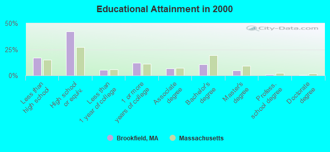
For population 25 years and over in Brookfield:
- High school or higher: 83.2%
- Bachelor's degree or higher: 16.8%
- Graduate or professional degree: 6.1%
- Unemployed: 4.1%
- Mean travel time to work (commute): 32.4 minutes

| Here: | 10.0 |
| Massachusetts average: | 13.1 |


Graphs represent county-level data. Detailed 2008 Election Results
Religion statistics for Brookfield, MA (based on Worcester County data)


| Religion | Adherents | Congregations |
|---|---|---|
| Catholic | 306,925 | 118 |
| Mainline Protestant | 43,326 | 171 |
| Evangelical Protestant | 37,511 | 203 |
| Other | 18,931 | 69 |
| Orthodox | 7,935 | 15 |
| Black Protestant | 497 | 6 |
| None | 383,427 | - |
Food Environment Statistics:
| Worcester County: | 1.73 / 10,000 pop. |
| Massachusetts: | 1.98 / 10,000 pop. |
| Here: | 0.05 / 10,000 pop. |
| Massachusetts: | 0.05 / 10,000 pop. |
| Worcester County: | 1.79 / 10,000 pop. |
| Massachusetts: | 2.22 / 10,000 pop. |
| Worcester County: | 2.22 / 10,000 pop. |
| Massachusetts: | 1.77 / 10,000 pop. |
| Worcester County: | 7.27 / 10,000 pop. |
| Massachusetts: | 8.76 / 10,000 pop. |
| Worcester County: | 8.0% |
| Massachusetts: | 8.1% |
| Worcester County: | 24.0% |
| Massachusetts: | 22.5% |
| Worcester County: | 16.6% |
| Massachusetts: | 16.5% |
4.71% of this county's 2021 resident taxpayers lived in other counties in 2020 ($76,229 average adjusted gross income)
| Here: | 4.71% |
| Massachusetts average: | 6.35% |
0.02% of residents moved from foreign countries ($100 average AGI)
Worcester County: 0.02% Massachusetts average: 0.01%
Top counties from which taxpayers relocated into this county between 2020 and 2021:
| from Middlesex County, MA | |
| from Norfolk County, MA | |
| from Suffolk County, MA |
4.84% of this county's 2020 resident taxpayers moved to other counties in 2021 ($87,252 average adjusted gross income)
| Here: | 4.84% |
| Massachusetts average: | 7.18% |
0.03% of residents moved to foreign countries ($199 average AGI)
Worcester County: 0.03% Massachusetts average: 0.02%
Top counties to which taxpayers relocated from this county between 2020 and 2021:
| to Middlesex County, MA | |
| to Norfolk County, MA | |
| to Suffolk County, MA |
Businesses in Brookfield, MA
- U-Haul: 1
Strongest AM radio stations in Brookfield:
- WVNE (760 AM; daytime; 25 kW; LEICESTER, MA; Owner: BLOUNT MASSCOM, INC.)
- WCRN (830 AM; 50 kW; WORCESTER, MA; Owner: CARTER BROADCASTING CORPORATION)
- WARE (1250 AM; 5 kW; WARE, MA; Owner: SUCCESS SIGNAL BROADCASTING, INC.)
- WNNZ (640 AM; 50 kW; WESTFIELD, MA; Owner: CLEAR CHANNEL BROADCASTING LICENSES, INC.)
- WALE (990 AM; 50 kW; GREENVILLE, RI; Owner: NORTH AMERICAN BROADCASTING CO., INC.)
- WKOX (1200 AM; 50 kW; FRAMINGHAM, MA; Owner: CAPSTAR TX LIMITED PARTNERSHIP)
- WBIX (1060 AM; 40 kW; NATICK, MA; Owner: LANGER BROADCASTING CORPORATION)
- WEEI (850 AM; 50 kW; BOSTON, MA; Owner: ENTERCOM BOSTON LICENSE, LLC)
- WRKO (680 AM; 50 kW; BOSTON, MA; Owner: ENTERCOM BOSTON LICENSE, LLC)
- WTAG (580 AM; 5 kW; WORCESTER, MA; Owner: CAPSTAR TX LIMITED PARTNERSHIP)
- WAMG (890 AM; 25 kW; DEDHAM, MA; Owner: MEGA COMMUNICATIONS OF DEDHAM LICENSEE, LLC)
- WTIC (1080 AM; 50 kW; HARTFORD, CT; Owner: INFINITY RADIO OPERATIONS INC.)
- WORC (1310 AM; 5 kW; WORCESTER, MA; Owner: CHOWDER BROADCAST GROUP LLC)
Strongest FM radio stations in Brookfield:
- WAAF (107.3 FM; WORCESTER, MA; Owner: ENTERCOM BOSTON LICENSE, LLC)
- WSRS (96.1 FM; WORCESTER, MA; Owner: CAPSTAR TX LIMITED PARTNERSHIP)
- WYCM (90.1 FM; CHARLTON, MA; Owner: BAY PATH VOCATIONAL HIGH SCHOOL)
- WBPR (91.9 FM; WORCESTER, MA; Owner: UNIVERSITY OF MASSACHUSETTS)
- WFCR (88.5 FM; AMHERST, MA; Owner: UNIVERSITY OF MASSACHUSETTS)
- WWFX (100.1 FM; SOUTHBRIDGE, MA; Owner: CITADEL BROADCASTING COMPANY)
- WORC-FM (98.9 FM; WEBSTER, MA; Owner: CITADEL BROADCASTING COMPANY)
- WAMH (89.3 FM; AMHERST, MA; Owner: TRUSTEES OF AMHERST COLLEGE)
- WHYN-FM (93.1 FM; SPRINGFIELD, MA; Owner: CLEAR CHANNEL BROADCASTING LICENSES, INC.)
- WRNX (100.9 FM; AMHERST, MA; Owner: WESTERN MASSACHUSETTS RADIO COMPANY)
- W246AM (97.1 FM; AMHERST, MA; Owner: GREAT NORTHERN RADIO, LLC)
- WXLO (104.5 FM; FITCHBURG, MA; Owner: CITADEL BROADCASTING COMPANY)
- WFEX (92.1 FM; PETERBOROUGH, NH; Owner: FNX BROADCASTING OF NEW HAMPSHIRE LLC)
- WICN (90.5 FM; WORCESTER, MA; Owner: WICN PUBLIC RADIO, INC)
- WAMC-FM (90.3 FM; ALBANY, NY; Owner: WAMC)
- WAQY (102.1 FM; SPRINGFIELD, MA; Owner: SAGA COMMUNICATIONS OF NEW ENGLAND, LLC)
- WBMX (98.5 FM; BOSTON, MA; Owner: INFINITY RADIO OPERATIONS INC.)
- WJMN (94.5 FM; BOSTON, MA; Owner: AMFM RADIO LICENSES, L.L.C.)
- WCRB (102.5 FM; WALTHAM, MA; Owner: CHARLES RIVER BROADCASTING WCRB LICE)
- WTKK (96.9 FM; BOSTON, MA; Owner: GREATER BOSTON RADIO, INC.)
TV broadcast stations around Brookfield:
- WYDN (Channel 48; WORCESTER, MA; Owner: EDUCATIONAL PUBLIC TV CORPORATION)
- WUNI (Channel 27; WORCESTER, MA; Owner: ENTRAVISION HOLDINGS, LLC)
- WCRN-LP (Channel 34; LEICESTER, MA; Owner: CARTER BROADCASTING CORPORATION)
- WUTF (Channel 66; MARLBOROUGH, MA; Owner: TELEFUTURA BOSTON LLC)
- WCVB-TV (Channel 5; BOSTON, MA; Owner: WCVB HEARST-ARGYLE TV, INC.)
- WGBH-TV (Channel 2; BOSTON, MA; Owner: WGBH EDUCATIONAL FOUNDATION)
- WTIC-TV (Channel 61; HARTFORD, CT; Owner: TRIBUNE TELEVISION COMPANY)
- WPXQ (Channel 69; BLOCK ISLAND, RI; Owner: OCEAN STATE TELEVISION, L.L.C.)
- WMFP (Channel 62; LAWRENCE, MA; Owner: WSAH LICENSE, INC.)
- WBZ-TV (Channel 4; BOSTON, MA; Owner: VIACOM INC.)
- WGBX-TV (Channel 44; BOSTON, MA; Owner: WGBH EDUCATIONAL FOUNDATION)
- WSBK-TV (Channel 38; BOSTON, MA; Owner: VIACOM INC.)
- WLVI-TV (Channel 56; CAMBRIDGE, MA; Owner: WLVI, INC.)
- WFXT (Channel 25; BOSTON, MA; Owner: FOX TELEVISION STATIONS INC.)
- WUVN (Channel 18; HARTFORD, CT; Owner: ENTRAVISION HOLDINGS, LLC)
- National Bridge Inventory (NBI) Statistics
- 7Number of bridges
- 36ft / 11.2mTotal length
- $3,627,000Total costs
- 33,970Total average daily traffic
- 1,798Total average daily truck traffic
- 42,499Total future (year 21) average daily traffic
FCC Registered Antenna Towers:
13 (See the full list of FCC Registered Antenna Towers in Brookfield)FCC Registered Broadcast Land Mobile Towers:
2- High St (Lat: 42.211389 Lon: -72.093056), Type: Bant, Structure height: 9 m, Overall height: 12 m, Call Sign: WPUN399,
Assigned Frequencies: 42.4000 MHz, Grant Date: 02/02/2022, Expiration Date: 04/01/2032, Certifier: Richard P Hanlon, Registrant: Massachusetts, Commonwealth Of Department Of State Police, 470 Worcester Rd, Framingham, MA 01702, Phone: (774) 462-3767, Email:
- PUMP STATION, 1 Herbert Road (Lat: 42.201889 Lon: -72.052500), Type: Bant, Structure height: 3 m, Overall height: 4.5 m, Call Sign: WQFZ565,
Assigned Frequencies: 458.250 MHz, Grant Date: 08/20/2016, Expiration Date: 11/16/2026, Certifier: Bruce Clarke, Registrant: Business Radio Licensing, 30251 Golden Lantern, Suite E #501, Laguna Niguel, CA 92677, Phone: (949) 348-8510, Fax: (949) 348-8510, Email:
FCC Registered Microwave Towers:
2- STATION, Lat: 42.166750 Lon: -72.082833, Call Sign: WNTR392,
Assigned Frequencies: 952.618 MHz, Grant Date: 02/09/2018, Expiration Date: 03/31/2028, Registrant: Utilities Technology Council, 1129 20th St Nw, Suite 350, Washington, DC 20036, Phone: (202) 872-0030, Fax: (202) 872-1331, Email:
- RAGGED HILL, Off Ragged Hill Rd (Lat: 42.288361 Lon: -72.182750), Type: Ltower, Structure height: 55.8 m, Call Sign: WPOR399,
Assigned Frequencies: 6715.62 MHz, 11623.7 MHz, 11305.0 MHz, 6315.84 MHz, 6286.19 MHz, 11623.1 MHz, Grant Date: 10/30/2018, Expiration Date: 12/31/2028, Registrant: Massachusetts, Commonwealth Of, 470 Worcester Rd, Framingham, MA 01702, Phone: (508) 820-2264, Email:
FCC Registered Amateur Radio Licenses:
27 (See the full list of FCC Registered Amateur Radio Licenses in Brookfield)FAA Registered Aircraft:
4- Aircraft: CESSNA 172N (Category: Land, Seats: 4, Weight: Up to 12,499 Pounds, Speed: 105 mph), Engine: LYCOMING 0-320 SERIES (180 HP) (Reciprocating)
N-Number: 102AC, N102AC, N-102AC, Serial Number: 17271882, Airworthiness Date: 05/26/1988, Certificate Issue Date: 02/23/2019
Registrant (Individual): Douglas A Lord, 29 Town Farm Rd, Brookfield, MA 01506 - Aircraft: CESSNA 172D (Category: Land, Seats: 4, Weight: Up to 12,499 Pounds, Speed: 105 mph), Engine: CONT MOTOR 0-300 SER (145 HP) (Reciprocating)
N-Number: 2445Y, N2445Y, N-2445Y, Serial Number: 17249745, Year manufactured: 1962, Airworthiness Date: 10/25/1962, Certificate Issue Date: 06/02/2016
Registrant (Individual): Frank N Mosher, 70 Quaboag St, Brookfield, MA 01506 - Aircraft: PIPER PA-28-235 (Category: Land, Seats: 4, Weight: Up to 12,499 Pounds, Speed: 107 mph), Engine: LYCOMING 0-540 SERIES (250 HP) (Reciprocating)
N-Number: 8548N, N8548N, N-8548N, Serial Number: 28-11347, Year manufactured: 1969, Airworthiness Date: 10/01/1969, Certificate Issue Date: 11/12/2019
Registrant (Corporation): Sagendorph Paul Reymann Ii, 43 Fiskdale Rd, Brookfield, MA 01506 - Aircraft: AEROSTAR INTERNATIONAL INC RX 8 (Category: Land, Weight: Up to 12,499 Pounds), Engine: None
N-Number: 6359E, N6359E, N-6359E, Serial Number: RX8-3130, Year manufactured: 1991, Airworthiness Date: 11/04/1991, Certificate Issue Date: 12/12/1991
Registrant (Corporation): Worcester County Hot Air Ballooning, 57 Shore Rd, N Brookfield, MA 01535
Deregistered: Cancel Date: 09/06/2019
2002 - 2018 National Fire Incident Reporting System (NFIRS) incidents
- Fire incident types reported to NFIRS in Brookfield, MA
- 10471.7%Structure Fires
- 2215.2%Outside Fires
- 1510.3%Other
- 42.8%Mobile Property/Vehicle Fires
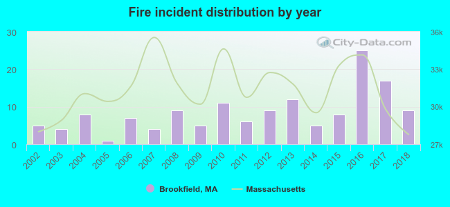 Based on the data from the years 2002 - 2018 the average number of fire incidents per year is 9. The highest number of reported fire incidents - 25 took place in 2016, and the least - 1 in 2005. The data has a rising trend.
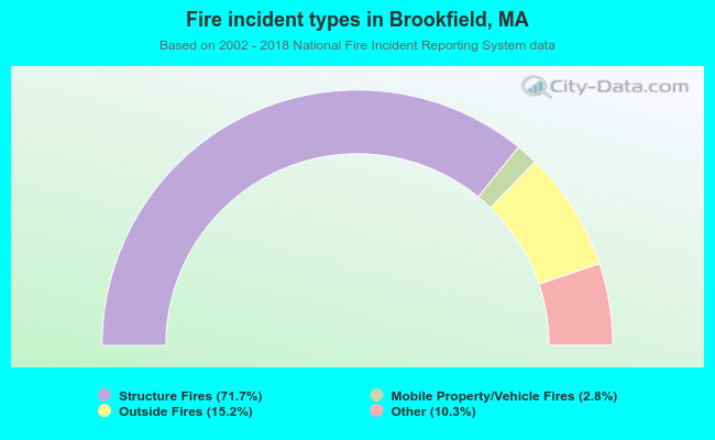 When looking into fire subcategories, the most reports belonged to: Structure Fires (71.7%), and Outside Fires (15.2%).
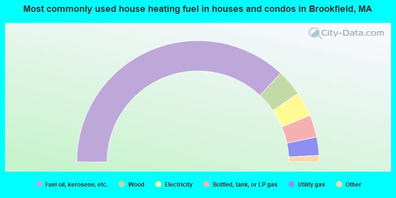
- 73.9%Fuel oil, kerosene, etc.
- 7.0%Wood
- 6.6%Electricity
- 5.9%Bottled, tank, or LP gas
- 4.9%Utility gas
- 1.4%Other fuel
- 0.3%Coal or coke
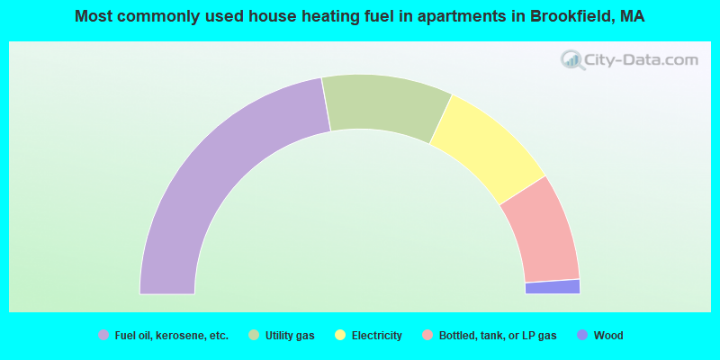
- 44.4%Fuel oil, kerosene, etc.
- 19.4%Utility gas
- 18.1%Electricity
- 15.9%Bottled, tank, or LP gas
- 2.2%Wood
Brookfield compared to Massachusetts state average:
- Median house value below state average.
- Unemployed percentage significantly below state average.
- Black race population percentage significantly below state average.
- Hispanic race population percentage significantly below state average.
- Median age above state average.
- Foreign-born population percentage significantly below state average.
- Renting percentage below state average.
- Length of stay since moving in significantly above state average.
- Number of rooms per house significantly below state average.
- House age significantly below state average.
- Percentage of population with a bachelor's degree or higher below state average.

|
|
Total of 25 patent applications in 2008-2024.