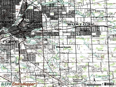
Burton, Michigan
Submit your own pictures of this city and show them to the world
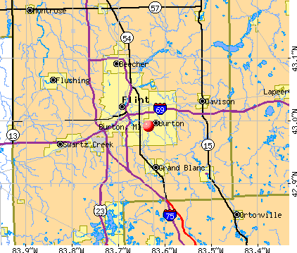
- OSM Map
- General Map
- Google Map
- MSN Map
Population change since 2000: -2.8%
 |
| Males: 13,547 | |
| Females: 15,902 |
| Median resident age: | 43.0 years |
| Michigan median age: | 40.3 years |
Zip codes: 48439, 48506, 48509, 48519, 48529.
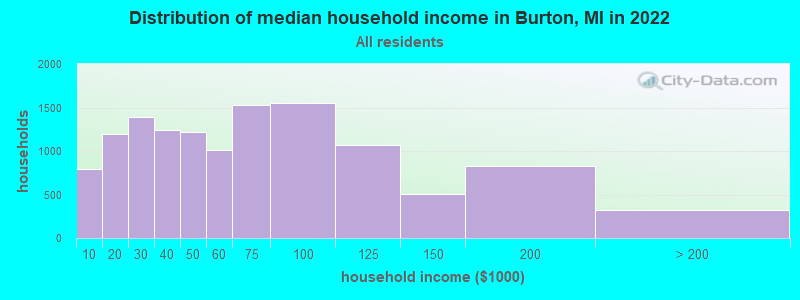
Burton Zip Code Map| Burton: | $54,186 |
| MI: | $66,986 |
Estimated per capita income in 2022: $30,489 (it was $20,548 in 2000)
Burton city income, earnings, and wages data
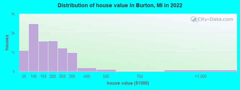
Estimated median house or condo value in 2022: $133,839 (it was $81,100 in 2000)
| Burton: | $133,839 |
| MI: | $224,400 |
Mean prices in 2022: all housing units: $181,792; detached houses: $188,085; townhouses or other attached units: $189,501; in 2-unit structures: $138,838; in 3-to-4-unit structures: $149,011; in 5-or-more-unit structures: $92,797; mobile homes: $47,804
Median gross rent in 2022: $874.
(15.5% for White Non-Hispanic residents, 28.4% for Black residents, 3.4% for Hispanic or Latino residents, 10.0% for American Indian residents, 19.1% for two or more races residents)
Detailed information about poverty and poor residents in Burton, MI

Compare current foreclosures in Burton, MI:
| Photo | Address | Area | Beds / Baths | Price | Details |
|---|---|---|---|---|---|

|
#1
Alcott St
Burton, MI 48509
|
2,184 sq. feet
|
2 baths 5 beds |
show details | |

|
#2
Dahlia Dr
Burton, MI 48519
|
- sq. feet
|
2 baths 3 beds |
show details | |

|
#3
Dublin Rd
Burton, MI 48529
|
- sq. feet
|
2 baths 4 beds |
show details | |

|
#4
Harbor Crk
Burton, MI 48519
|
- sq. feet
|
- baths - beds |
show details | |

|
#5
Springfield St
Burton, MI 48509
|
- sq. feet
|
- baths - beds |
show details | |

|
#6
E Parkwood Ave
Burton, MI 48529
|
- sq. feet
|
- baths - beds |
show details | |

|
#7
Sparrow
Burton, MI 48519
|
- sq. feet
|
- baths - beds |
show details | |

|
#8
E Boltfiled
Burton, MI 48529
|
- sq. feet
|
- baths - beds |
show details | |

|
#9
Royal Oak
Burton, MI 48519
|
- sq. feet
|
- baths - beds |
show details | |

|
#10
Creekside Blvd
Burton, MI 48519
|
- sq. feet
|
- baths - beds |
show details |
| Photo | Address | Area | Beds / Baths | Price | Details |
|---|---|---|---|---|---|

|
#11
Yorkbrook
Burton, MI 48519
|
- sq. feet
|
- baths - beds |
show details | |

|
#12
E Whittemore Ave
Burton, MI 48529
|
- sq. feet
|
- baths - beds |
show details | |

|
#13
Blackberry Crk
Burton, MI 48519
|
- sq. feet
|
- baths - beds |
show details | |

|
#14
Rustic # 42
Burton, MI 48519
|
- sq. feet
|
- baths - beds |
show details | |

|
#15
S Saginaw St
Burton, MI 48529
|
- sq. feet
|
- baths - beds |
show details | |

|
#16
Hunter Ln
Burton, MI 48519
|
- sq. feet
|
- baths - beds |
show details | |

|
#17
Blackberry Crk
Burton, MI 48519
|
- sq. feet
|
- baths - beds |
show details | |

|
#18
E Schumacher St
Burton, MI 48529
|
- sq. feet
|
- baths - beds |
show details | |

|
#19
Creekside Blvd
Burton, MI 48519
|
- sq. feet
|
- baths - beds |
show details | |

|
#20
S Center Rd Apt 101
Burton, MI 48519
|
- sq. feet
|
- baths - beds |
show details |
| Photo | Address | Area | Beds / Baths | Price | Details |
|---|---|---|---|---|---|

|
#21
Ludwig St
Burton, MI 48529
|
- sq. feet
|
- baths - beds |
show details | |

|
#22
Heritage Ln
Burton, MI 48509
|
- sq. feet
|
- baths - beds |
show details | |

|
#23
Ryanbrook
Burton, MI 48519
|
- sq. feet
|
- baths - beds |
show details | |

|
#24
E Bristol Rd
Burton, MI 48529
|
- sq. feet
|
- baths - beds |
show details | |

|
#25
E Atherton Rd Apt 5
Burton, MI 48519
|
- sq. feet
|
- baths - beds |
show details | |

|
#26
E Schumacher St
Burton, MI 48529
|
- sq. feet
|
- baths - beds |
show details | |

|
#27
Chicory Ln
Burton, MI 48519
|
- sq. feet
|
- baths - beds |
show details | |

|
#28
Raspberry Ln
Burton, MI 48529
|
- sq. feet
|
- baths - beds |
show details | |

|
#29
Boulder Dr
Burton, MI 48529
|
- sq. feet
|
- baths - beds |
show details | |

|
#30
Woodrow Ave
Burton, MI 48509
|
- sq. feet
|
- baths - beds |
show details |
| Photo | Address | Area | Beds / Baths | Price | Details |
|---|---|---|---|---|---|

|
#31
Briar Downs Ln
Burton, MI 48529
|
- sq. feet
|
- baths - beds |
show details | |

|
#32
Pine Drive, Apt 2
Burton, MI 48519
|
- sq. feet
|
- baths - beds |
show details | |

|
#33
1/2 Davison Rd, Lot 37
Burton, MI 48509
|
- sq. feet
|
- baths - beds |
show details | |

|
#34
E Atherton Rd
Burton, MI 48519
|
- sq. feet
|
- baths - beds |
show details | |

|
#35
Hunter Ln
Burton, MI 48519
|
- sq. feet
|
- baths - beds |
show details | |

|
#36
Shubert Ave
Burton, MI 48529
|
- sq. feet
|
- baths - beds |
show details | |

|
#37
Lippincott Blvd
Burton, MI 48519
|
- sq. feet
|
- baths - beds |
show details | |

|
#38
Fenton Rd
Burton, MI 48529
|
- sq. feet
|
- baths - beds |
show details | |

|
#39
Hillary Crk
Burton, MI 48519
|
- sq. feet
|
- baths - beds |
show details | |

|
#40
Briar Downs Ln
Burton, MI 48529
|
- sq. feet
|
- baths - beds |
show details |
| Photo | Address | Area | Beds / Baths | Price | Details |
|---|---|---|---|---|---|

|
#41
E Bristol Rd
Burton, MI 48529
|
- sq. feet
|
- baths - beds |
show details | |

|
#42
E Schumacher St
Burton, MI 48529
|
- sq. feet
|
- baths - beds |
show details | |

|
#43
Alcott St
Burton, MI 48509
|
- sq. feet
|
- baths - beds |
show details | |

|
#44
Mcewen St
Burton, MI 48509
|
- sq. feet
|
- baths - beds |
show details | |

|
#45
E Boatfield Ave
Burton, MI 48529
|
- sq. feet
|
- baths - beds |
show details | |

|
#46
E Decamp St
Burton, MI 48529
|
- sq. feet
|
- baths - beds |
show details | |

|
#47
Munson St
Burton, MI 48509
|
- sq. feet
|
- baths - beds |
show details | |

|
#48
Pine Creek Dr
Burton, MI 48519
|
- sq. feet
|
- baths - beds |
show details | |

|
#49
E Whittemore Ave
Burton, MI 48529
|
- sq. feet
|
- baths - beds |
show details | |

|
Check over 1 million property listings on Foreclosure.com!
|
browse all offers | |||


- 23,22079.2%White alone
- 2,8619.8%Black alone
- 1,4044.8%Hispanic
- 1,3434.6%Two or more races
- 3621.2%Asian alone
- 450.2%American Indian alone
- 470.2%Other race alone
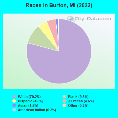
Races in Burton detailed stats: ancestries, foreign born residents, place of birth
According to our research of Michigan and other state lists, there were 139 registered sex offenders living in Burton, Michigan as of April 19, 2024.
The ratio of all residents to sex offenders in Burton is 206 to 1.
Type |
2009 |
2010 |
2011 |
2012 |
2013 |
2014 |
2015 |
2016 |
2017 |
2018 |
2019 |
2020 |
2021 |
2022 |
|---|---|---|---|---|---|---|---|---|---|---|---|---|---|---|
| Murders (per 100,000) | 2 (6.7) | 2 (6.7) | 0 (0.0) | 1 (3.4) | 2 (6.8) | 0 (0.0) | 0 (0.0) | 2 (7.0) | 2 (7.0) | 1 (3.5) | 2 (7.0) | 2 (7.0) | 1 (3.5) | 4 (13.6) |
| Rapes (per 100,000) | 18 (60.4) | 3 (10.0) | 24 (80.1) | 14 (47.0) | 21 (71.8) | 25 (86.2) | 23 (80.0) | 23 (80.5) | 22 (77.4) | 27 (94.9) | 20 (70.2) | 27 (95.0) | 20 (70.6) | 23 (78.3) |
| Robberies (per 100,000) | 51 (171.2) | 18 (60.0) | 59 (196.8) | 55 (184.8) | 34 (116.2) | 35 (120.7) | 32 (111.3) | 20 (70.0) | 21 (73.8) | 17 (59.7) | 18 (63.2) | 11 (38.7) | 14 (49.4) | 11 (37.4) |
| Assaults (per 100,000) | 72 (241.7) | 54 (180.0) | 88 (293.6) | 74 (248.7) | 62 (211.9) | 78 (269.0) | 65 (226.2) | 64 (224.1) | 87 (305.9) | 85 (298.6) | 96 (336.9) | 158 (555.8) | 175 (618.0) | 204 (694.5) |
| Burglaries (per 100,000) | 389 (1,306) | 204 (680.0) | 430 (1,434) | 446 (1,499) | 346 (1,182) | 272 (938.1) | 183 (636.8) | 120 (420.1) | 111 (390.3) | 135 (474.3) | 120 (421.1) | 104 (365.8) | 111 (392.0) | 99 (337.0) |
| Thefts (per 100,000) | 1,132 (3,800) | 598 (1,993) | 906 (3,022) | 1,090 (3,663) | 888 (3,035) | 911 (3,142) | 759 (2,641) | 607 (2,125) | 494 (1,737) | 484 (1,700) | 526 (1,846) | 491 (1,727) | 537 (1,896) | 559 (1,903) |
| Auto thefts (per 100,000) | 86 (288.7) | 34 (113.3) | 67 (223.5) | 58 (194.9) | 45 (153.8) | 39 (134.5) | 47 (163.5) | 35 (122.5) | 51 (179.3) | 69 (242.4) | 88 (308.8) | 58 (204.0) | 83 (293.1) | 83 (282.6) |
| Arson (per 100,000) | 5 (16.8) | 4 (13.3) | 18 (60.0) | 25 (84.0) | 4 (13.7) | 5 (17.2) | 10 (34.8) | 5 (17.5) | 2 (7.0) | 5 (17.6) | 0 (0.0) | 2 (7.0) | 5 (17.7) | 1 (3.4) |
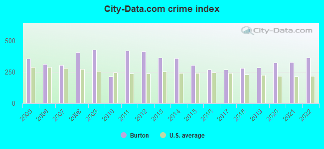
| City-Data.com crime index | 428.0 | 211.7 | 421.0 | 416.6 | 364.8 | 361.1 | 306.0 | 268.5 | 270.4 | 281.2 | 284.5 | 323.8 | 328.7 | 362.3 |
The City-Data.com crime index weighs serious crimes and violent crimes more heavily. Higher means more crime, U.S. average is 246.1. It adjusts for the number of visitors and daily workers commuting into cities.
Crime rate in Burton detailed stats: murders, rapes, robberies, assaults, burglaries, thefts, arson
Full-time law enforcement employees in 2021, including police officers: 34 (32 officers - 26 male; 6 female).
| Officers per 1,000 residents here: | 1.13 |
| Michigan average: | 1.86 |
 Recent articles from our blog. Our writers, many of them Ph.D. graduates or candidates, create easy-to-read articles on a wide variety of topics.


 | Likes and Dislikes about Metro Detroit (131 replies) |
| Flint Water Crisis (400 replies) |
| Considering Farmington Hills.... (92 replies) |
| burton flooding (0 replies) |
| Taking bus to downtown from Algier Heights (46 replies) |
| Things that GR is missing or would like to see there. (66 replies) |
Latest news from Burton, MI collected exclusively by city-data.com from local newspapers, TV, and radio stations
Ancestries: American (17.6%), English (10.3%), Irish (7.8%), German (6.7%), Polish (3.0%), European (2.6%).
Current Local Time: EST time zone
Elevation: 774 feet
Land area: 23.5 square miles.
Population density: 1,255 people per square mile (low).
535 residents are foreign born
| This city: | 1.8% |
| Michigan: | 6.9% |
Median real estate property taxes paid for housing units with mortgages in 2022: $2,363 (1.5%)
Median real estate property taxes paid for housing units with no mortgage in 2022: $1,794 (1.6%)
Nearest city with pop. 50,000+: Flint, MI  (3.9 miles , pop. 124,943).
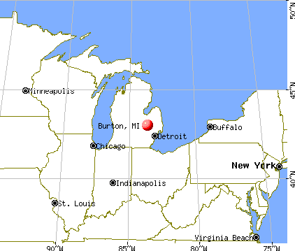
Nearest city with pop. 200,000+: Detroit, MI (49.8 miles , pop. 951,270).
Nearest city with pop. 1,000,000+: Chicago, IL (221.3 miles , pop. 2,896,016).
Nearest cities:
), ), ), ), Latitude: 42.99 N, Longitude: 83.64 W
Daytime population change due to commuting: -3,941 (-13.4%)
Workers who live and work in this city: 3,274 (23.8%)
Area code commonly used in this area: 810

Burton tourist attractions:
Burton, Michigan accommodation & food services, waste management - Economy and Business Data
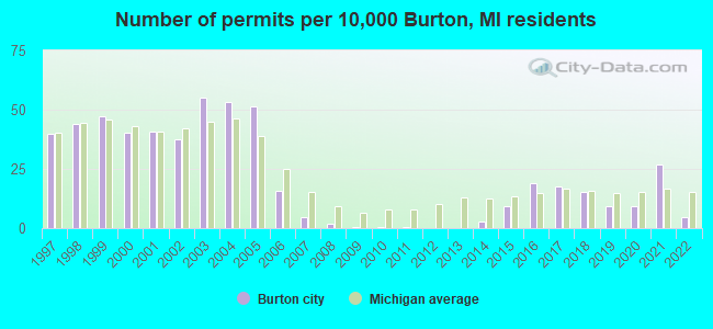
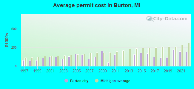
Single-family new house construction building permits:
- 2022: 14 buildings, average cost: $190,800
- 2021: 81 buildings, average cost: $196,300
- 2020: 28 buildings, average cost: $219,800
- 2019: 28 buildings, average cost: $117,600
- 2018: 46 buildings, average cost: $113,600
- 2017: 53 buildings, average cost: $124,600
- 2016: 58 buildings, average cost: $168,700
- 2015: 28 buildings, average cost: $177,700
- 2014: 8 buildings, average cost: $157,000
- 2011: 2 buildings, average cost: $157,000
- 2010: 2 buildings, average cost: $51,800
- 2009: 1 building, cost: $200,000
- 2008: 6 buildings, average cost: $124,500
- 2007: 14 buildings, average cost: $100,300
- 2006: 47 buildings, average cost: $156,300
- 2005: 156 buildings, average cost: $168,100
- 2004: 162 buildings, average cost: $129,700
- 2003: 167 buildings, average cost: $100,100
- 2002: 113 buildings, average cost: $128,400
- 2001: 124 buildings, average cost: $122,000
- 2000: 122 buildings, average cost: $110,200
- 1999: 143 buildings, average cost: $81,000
- 1998: 134 buildings, average cost: $81,100
- 1997: 120 buildings, average cost: $80,900
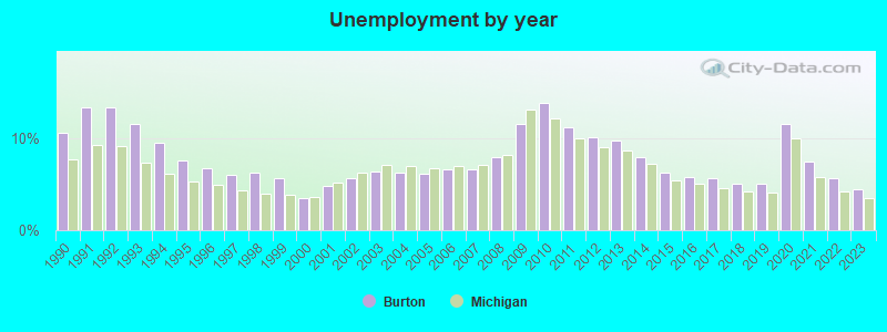
| Here: | 4.4% |
| Michigan: | 3.5% |
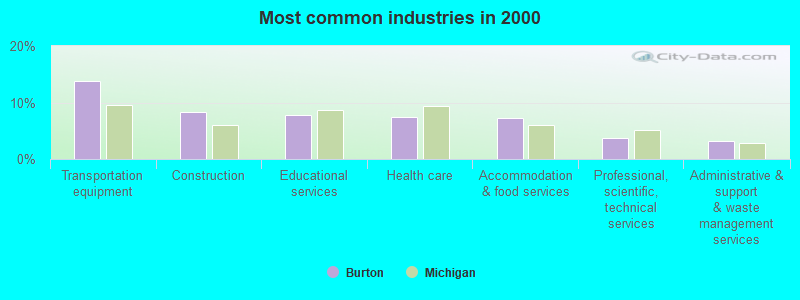
- Transportation equipment (13.7%)
- Construction (8.4%)
- Educational services (7.8%)
- Health care (7.5%)
- Accommodation & food services (7.2%)
- Professional, scientific, technical services (3.7%)
- Administrative & support & waste management services (3.3%)
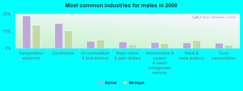
- Transportation equipment (19.0%)
- Construction (14.4%)
- Accommodation & food services (4.1%)
- Motor vehicle & parts dealers (3.7%)
- Administrative & support & waste management services (3.4%)
- Metal & metal products (3.2%)
- Truck transportation (3.0%)
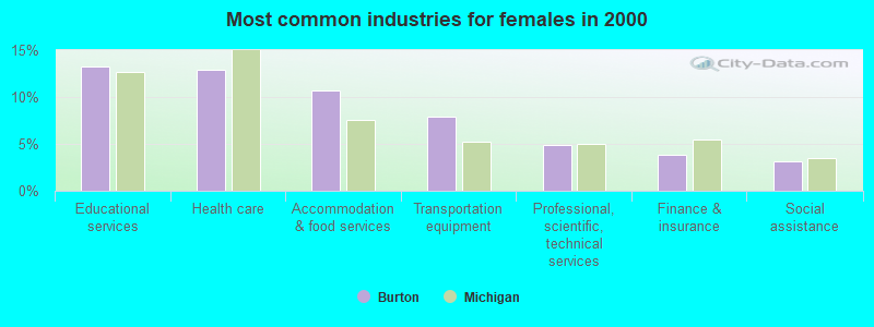
- Educational services (13.2%)
- Health care (13.0%)
- Accommodation & food services (10.7%)
- Transportation equipment (7.8%)
- Professional, scientific, technical services (4.9%)
- Finance & insurance (3.8%)
- Social assistance (3.2%)
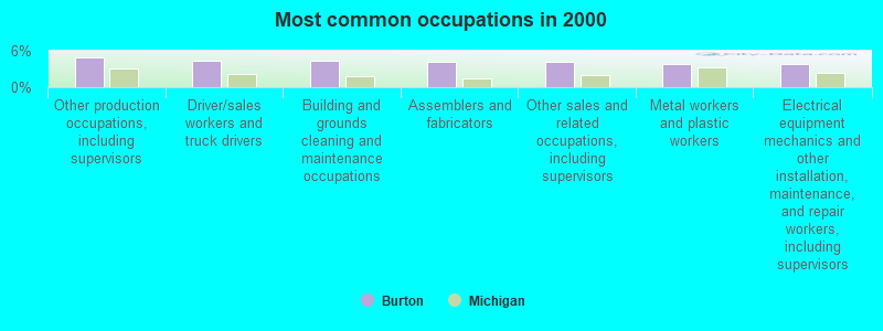
- Other production occupations, including supervisors (4.9%)
- Driver/sales workers and truck drivers (4.3%)
- Building and grounds cleaning and maintenance occupations (4.3%)
- Assemblers and fabricators (4.2%)
- Other sales and related occupations, including supervisors (4.2%)
- Metal workers and plastic workers (3.9%)
- Electrical equipment mechanics and other installation, maintenance, and repair workers, including supervisors (3.8%)
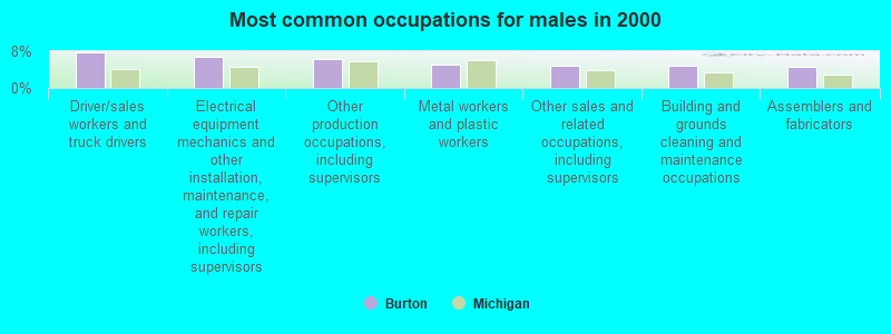
- Driver/sales workers and truck drivers (7.8%)
- Electrical equipment mechanics and other installation, maintenance, and repair workers, including supervisors (6.8%)
- Other production occupations, including supervisors (6.3%)
- Metal workers and plastic workers (5.2%)
- Other sales and related occupations, including supervisors (4.9%)
- Building and grounds cleaning and maintenance occupations (4.9%)
- Assemblers and fabricators (4.5%)
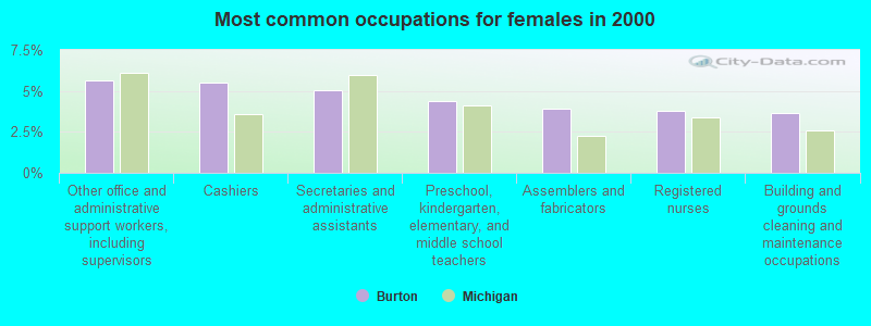
- Other office and administrative support workers, including supervisors (5.6%)
- Cashiers (5.5%)
- Secretaries and administrative assistants (5.0%)
- Preschool, kindergarten, elementary, and middle school teachers (4.4%)
- Assemblers and fabricators (3.9%)
- Registered nurses (3.8%)
- Building and grounds cleaning and maintenance occupations (3.6%)
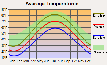
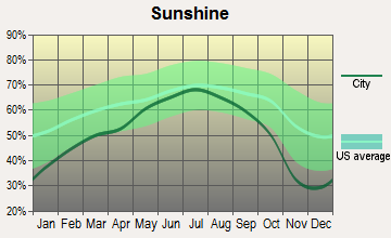
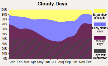
Average climate in Burton, Michigan
Based on data reported by over 4,000 weather stations
|
|

(lower is better)
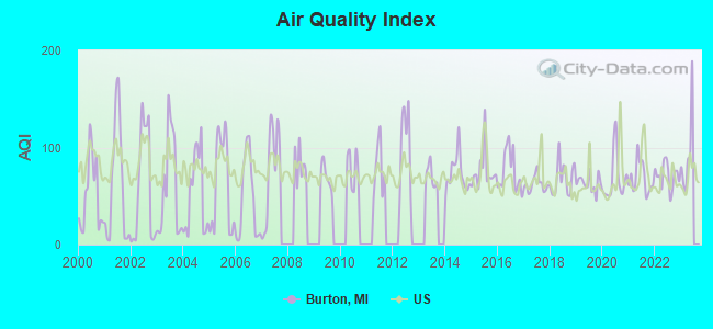
Air Quality Index (AQI) level in 2022 was 70.9. This is about average.
| City: | 70.9 |
| U.S.: | 72.6 |
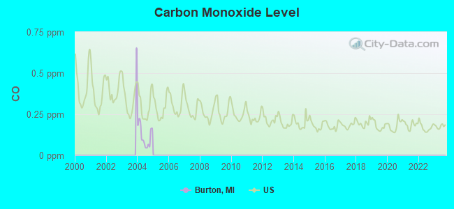
Carbon Monoxide (CO) [ppm] level in 2004 was 0.117. This is significantly better than average. Closest monitor was 3.5 miles away from the city center.
| City: | 0.117 |
| U.S.: | 0.251 |
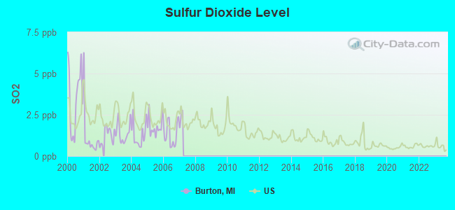
Sulfur Dioxide (SO2) [ppb] level in 2006 was 1.34. This is about average. Closest monitor was 3.0 miles away from the city center.
| City: | 1.34 |
| U.S.: | 1.51 |
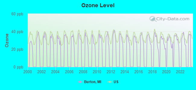
Ozone [ppb] level in 2022 was 31.7. This is about average. Closest monitor was 3.5 miles away from the city center.
| City: | 31.7 |
| U.S.: | 33.3 |
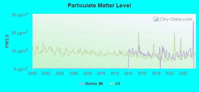
Particulate Matter (PM2.5) [µg/m3] level in 2022 was 8.25. This is about average. Closest monitor was 4.3 miles away from the city center.
| City: | 8.25 |
| U.S.: | 8.11 |
Tornado activity:
Burton-area historical tornado activity is above Michigan state average. It is 48% greater than the overall U.S. average.
On 6/8/1953, a category F5 (max. wind speeds 261-318 mph) tornado 13.2 miles away from the Burton city center killed 116 people and injured 844 people and caused between $5,000,000 and $50,000,000 in damages.
On 5/12/1956, a category F4 (max. wind speeds 207-260 mph) tornado 2.3 miles away from the city center killed 3 people and injured 116 people and caused between $500,000 and $5,000,000 in damages.
Earthquake activity:
Burton-area historical earthquake activity is significantly above Michigan state average. It is 49% smaller than the overall U.S. average.On 9/25/1998 at 19:52:52, a magnitude 5.2 (4.8 MB, 4.3 MS, 5.2 LG, 4.5 MW, Depth: 3.1 mi, Class: Moderate, Intensity: VI - VII) earthquake occurred 195.6 miles away from the city center
On 1/31/1986 at 16:46:43, a magnitude 5.0 (5.0 MB) earthquake occurred 159.0 miles away from the city center
On 5/2/2015 at 16:23:07, a magnitude 4.2 (4.2 MW, Depth: 2.8 mi, Class: Light, Intensity: IV - V) earthquake occurred 105.2 miles away from the city center
On 7/12/1986 at 08:19:37, a magnitude 4.5 (4.5 MB) earthquake occurred 173.9 miles away from Burton center
On 7/27/1980 at 18:52:21, a magnitude 5.2 (5.1 MB, 4.7 MS, 5.0 UK, 5.2 UK) earthquake occurred 331.4 miles away from Burton center
On 4/18/2008 at 09:36:59, a magnitude 5.4 (5.1 MB, 4.8 MS, 5.4 MW, 5.2 MW) earthquake occurred 384.9 miles away from the city center
Magnitude types: regional Lg-wave magnitude (LG), body-wave magnitude (MB), surface-wave magnitude (MS), moment magnitude (MW)
Natural disasters:
The number of natural disasters in Genesee County (13) is near the US average (15).Major Disasters (Presidential) Declared: 7
Emergencies Declared: 5
Causes of natural disasters: Storms: 7, Floods: 6, Tornadoes: 3, Winds: 2, Blizzard: 1, Hurricane: 1, Power Outage: 1, Snowstorm: 1, Winter Storm: 1, Other: 2 (Note: some incidents may be assigned to more than one category).
Hospitals and medical centers in Burton:
Amtrak stations near Burton:
- 2 miles: FLINT (1407 S. DORT HWY.) . Services: ticket office, partially wheelchair accessible, enclosed waiting area, public restrooms, public payphones, vending machines, free short-term parking, free long-term parking, call for car rental service, call for taxi service, public transit connection.
- 18 miles: LAPEER (73 HOWARD ST.) . Services: fully wheelchair accessible, enclosed waiting area, public restrooms, public payphones, free short-term parking, free long-term parking, call for taxi service.
- 19 miles: DURAND (200 RAILROAD ST.) . Services: enclosed waiting area, public restrooms, public payphones, free short-term parking, free long-term parking, taxi stand.
Colleges/universities with over 2000 students nearest to Burton:
- Mott Community College (about 3 miles; Flint, MI; Full-time enrollment: 7,394)
- Baker College Center for Graduate Studies (about 4 miles; Flint, MI; FT enrollment: 3,405)
- Baker College of Flint (about 4 miles; Flint, MI; FT enrollment: 3,877)
- University of Michigan-Flint (about 4 miles; Flint, MI; FT enrollment: 6,284)
- Kettering University (about 5 miles; Flint, MI; FT enrollment: 2,044)
- Baker College of Owosso (about 28 miles; Owosso, MI; FT enrollment: 2,081)
- Oakland Community College (about 28 miles; Bloomfield Hills, MI; FT enrollment: 18,956)
Public high schools in Burton:
- BENTLEY SENIOR HIGH SCHOOL (Students: 371, Location: 1150 NORTH BELSAY RD, Grades: 9-12)
- VERN VAN Y. SCHOOL (Students: 295, Location: 2400 CLARICE AVE, Grades: 9-12)
- BENDLE HIGH SCHOOL (Students: 274, Location: 2283 EAST SCOTTWOOD AVE, Grades: 9-12)
- MADISON ACADEMY - HIGH SCHOOL (Students: 272, Location: 3266 SOUTH GENESEE ROAD, Grades: 9-12, Charter school)
- ATHERTON JR. / SR. HIGH SCHOOL (Location: 3354 SOUTH GENESEE RD, Grades: 7-12)
- BENTLEY HIGH SCHOOL FUSION ACADEMY (Location: 1150 N BELSAY RD, Grades: 9-12)
Private high schools in Burton:
Public elementary/middle schools in Burton:
- BURTON GLEN CHARTER ACADEMY (Students: 689, Location: 4171 EAST ATHERTON RD, Grades: KG-8, Charter school)
- WESTON ELEMENTARY SCHOOL (Students: 454, Location: 2499 CASHIN ST, Grades: PK-1)
- ATHERTON ELEMENTARY SCHOOL (Students: 372, Location: 3444 SOUTH GENESEE RD, Grades: KG-6)
- GLADYS DILLON ELEMENTARY SCHOOL (Students: 357, Location: 1197 EAST SCHUMACHER ST, Grades: KG-3)
- BARHITTE ELEMENTARY SCHOOL (Students: 309, Location: 6080 ROBERTA ST, Grades: PK-5)
- BENTLEY JUNIOR HIGH SCHOOL (Students: 294, Location: 1180 N BELSAY RD, Grades: 6-8)
- SOUTH BENDLE ELEMENTARY SCHOOL (Students: 290, Location: 4341 LARKIN DR, Grades: PK-2)
- WEST BENDLE ELEMENTARY SCHOOL (Students: 264, Location: 4020 CERDAN DR, Grades: 3-5)
- BENDLE MIDDLE SCHOOL (Location: 2294 EAST BRISTOL RD, Grades: 6-8)
Private elementary/middle school in Burton:
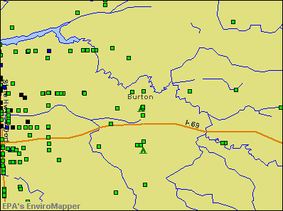
Points of interest:
Notable locations in Burton: Brookwood Golf Course (A), Belsay Station (B), Southmoor Golf Course (C), Universal Emergency Medical Services (D), Patriot Ambulance Service (E), Burton Library (F), Burton Fire Department Headquarters (G), Burton City Fire Station 2 (H), Burton City Fire Station 3 (I), Burton City Fire Station 1 (J). Display/hide their locations on the map
Shopping Centers: Eastland Mall Shopping Center (1), South Flint Plaza Shopping Center (2). Display/hide their locations on the map
Churches in Burton include: Eastgate Church (A), Hilltop Church (B), Saint Nicholas Church (C), Harmony Free Will Baptist Church (D), Valley Church of Christ (E), Southeast Christian Church (F), Our Risen Lord Lutheran Church (G), Atherton United Methodist Church (H), New Testament General Baptist Church (I). Display/hide their locations on the map
Cemetery: Peace Memory Gardens (1). Display/hide its location on the map
Streams, rivers, and creeks: Pierson Branch (A). Display/hide its location on the map
Parks in Burton include: Water Tower Park (1), Davison Roadside County Park (2), For-mar Nature Preserve (3). Display/hide their locations on the map
Tourist attractions: For-Mar Nature Preserve & Arboretum (Nature Centers; 2142 North Genesee Road) (1), Carlson Wagonlit Travel (Tours & Charters; 1235 South Center Road) (2). Display/hide their approximate locations on the map
Hotel: Crank's Motel (3030 East Hemphill Road) (1). Display/hide its approximate location on the map
Drinking water stations with addresses in Burton and their reported violations in the past:
BURTON, CITY OF (Population served: 20,900, Purch surface water):Past monitoring violations:NEW HAVEN BAPTIST CHURCH (Population served: 200, Groundwater):
- Monitoring and Reporting (DBP) - Between MAY-2013 and JUL-2013, Contaminant: TTHM. Follow-up actions: St Compliance achieved (OCT-30-2013), St Public Notif requested (DEC-11-2013), St Violation/Reminder Notice (DEC-11-2013)
- Monitoring and Reporting (DBP) - Between MAY-2013 and JUL-2013, Contaminant: Total Haloacetic Acids (HAA5). Follow-up actions: St Compliance achieved (OCT-30-2013), St Public Notif requested (DEC-11-2013), St Violation/Reminder Notice (DEC-11-2013)
- Monitoring and Reporting (DBP) - In APR-2013, Contaminant: TTHM. Follow-up actions: St Compliance achieved (OCT-30-2013), St Public Notif requested (DEC-11-2013), St Violation/Reminder Notice (DEC-11-2013)
- Monitoring and Reporting (DBP) - In APR-2013, Contaminant: Total Haloacetic Acids (HAA5). Follow-up actions: St Compliance achieved (OCT-30-2013), St Public Notif requested (DEC-11-2013), St Violation/Reminder Notice (DEC-11-2013)
- One minor monitoring violation
- 3 regular monitoring violations
Past monitoring violations:OLDE AUTUMN LOUNGE (Population served: 200, Groundwater):
- 4 routine major monitoring violations
- 3 regular monitoring violations
Past health violations:MEL'S DINER (Population served: 100, Groundwater):Past monitoring violations:
- MCL, Monthly (TCR) - In OCT-2011, Contaminant: Coliform. Follow-up actions: St Violation/Reminder Notice (NOV-01-2011), St Compliance achieved (NOV-10-2011)
- 5 routine major monitoring violations
- One regular monitoring violation
Past monitoring violations:SOUTHEAST CHRISTIAN CHURCH (Population served: 90, Groundwater):
- 3 regular monitoring violations
Past monitoring violations:RIVER OF LIFE MINISTRIES (Population served: 75, Groundwater):
- One regular monitoring violation
Past monitoring violations:NORTHPOINTE CHURCH (Population served: 25, Groundwater):
- One regular monitoring violation
Past monitoring violations:LITTLE CAESARS (Population served: 25, Groundwater):
- One routine major monitoring violation
- 2 regular monitoring violations
Past monitoring violations:
- 4 routine major monitoring violations
- 3 regular monitoring violations
Drinking water stations with addresses in Burton that have no violations reported:
- JUDSON BAPTIST CHURCH (Population served: 200, Primary Water Source Type: Groundwater)
- PILGRIM LUTHERAN CHURCH (Population served: 200, Primary Water Source Type: Groundwater)
- NEW TESTAMENT CHURCH (Population served: 110, Primary Water Source Type: Groundwater)
- PUZZLER'S PUB (Population served: 100, Primary Water Source Type: Groundwater)
- HUNGRY HOWIES (Population served: 100, Primary Water Source Type: Groundwater)
- MARTIN HARDWARE (Population served: 50, Primary Water Source Type: Groundwater)
- HARMONY BAPTIST CHURCH (Population served: 40, Primary Water Source Type: Groundwater)
- THE FLATS CONDO. ASSOC. (Population served: 25, Primary Water Source Type: Groundwater)
- M.B. CONOVER DENTAL OFFICE (Population served: 25, Primary Water Source Type: Groundwater)
| This city: | 2.5 people |
| Michigan: | 2.5 people |
| This city: | 67.2% |
| Whole state: | 66.0% |
| This city: | 8.4% |
| Whole state: | 6.4% |
Likely homosexual households (counted as self-reported same-sex unmarried-partner households)
- Lesbian couples: 0.4% of all households
- Gay men: 0.2% of all households
People in group quarters in Burton in 2010:
- 85 people in group homes intended for adults
- 17 people in college/university student housing
- 6 people in residential treatment centers for adults
- 2 people in workers' group living quarters and job corps centers
People in group quarters in Burton in 2000:
- 42 people in homes for the mentally retarded
- 34 people in other group homes
- 18 people in other noninstitutional group quarters
- 12 people in homes for the mentally ill
- 4 people in religious group quarters
Banks with branches in Burton (2011 data):
- JPMorgan Chase Bank, National Association: Davison Donegal Branch, Bentley Branch, Burton Heights Branch. Info updated 2011/11/10: Bank assets: $1,811,678.0 mil, Deposits: $1,190,738.0 mil, headquarters in Columbus, OH, positive income, International Specialization, 5577 total offices, Holding Company: Jpmorgan Chase & Co.
- Bank of America, National Association: Burton at 4280 East Court Street, branch established on 1999/04/26; I-475 Branch at 1318 East Bristol Road, branch established on 1979/12/10. Info updated 2009/11/18: Bank assets: $1,451,969.3 mil, Deposits: $1,077,176.8 mil, headquarters in Charlotte, NC, positive income, 5782 total offices, Holding Company: Bank Of America Corporation
- Fifth Third Bank: Maple Road Branch at 4512 Saginaw, branch established on 1976/02/02; Center Road Banking Center Branch at 2315 S. Center Road, branch established on 2006/01/17. Info updated 2009/10/05: Bank assets: $114,540.4 mil, Deposits: $89,689.1 mil, headquarters in Cincinnati, OH, positive income, Commercial Lending Specialization, 1378 total offices, Holding Company: Fifth Third Bancorp
For population 15 years and over in Burton:
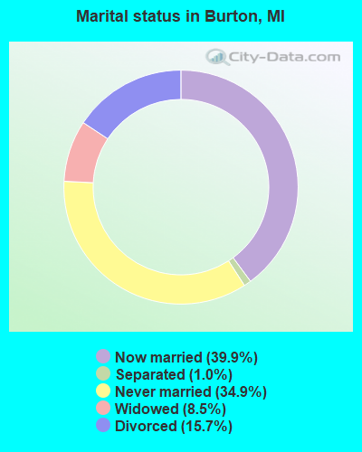
- Never married: 34.9%
- Now married: 39.9%
- Separated: 1.0%
- Widowed: 8.5%
- Divorced: 15.7%
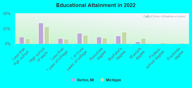
For population 25 years and over in Burton:
- High school or higher: 89.7%
- Bachelor's degree or higher: 16.2%
- Graduate or professional degree: 4.2%
- Unemployed: 5.5%
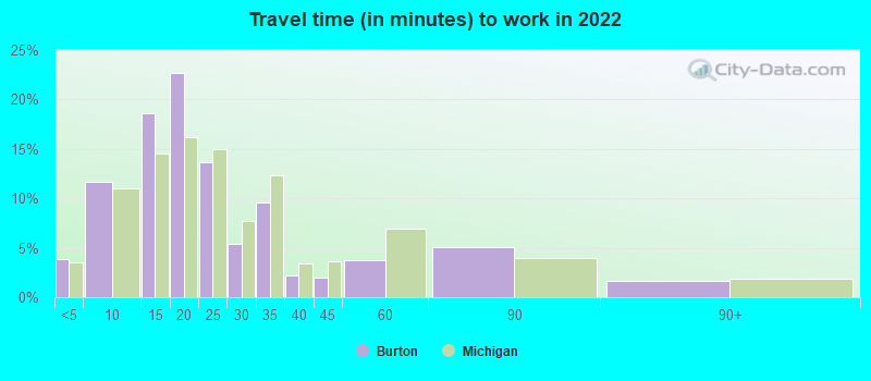
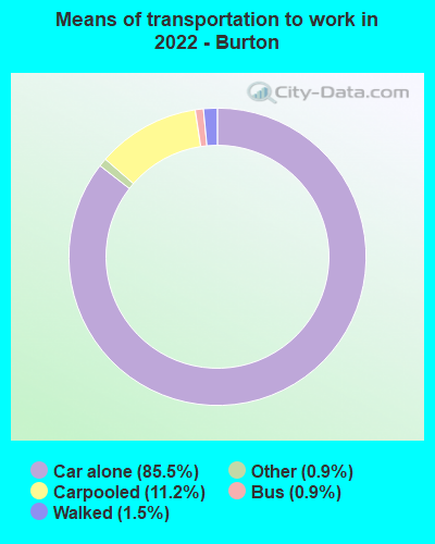
- Mean travel time to work (commute): 23.1 minutes
| Here: | 9.1 |
| Michigan average: | 11.0 |
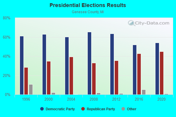
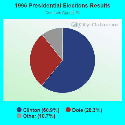
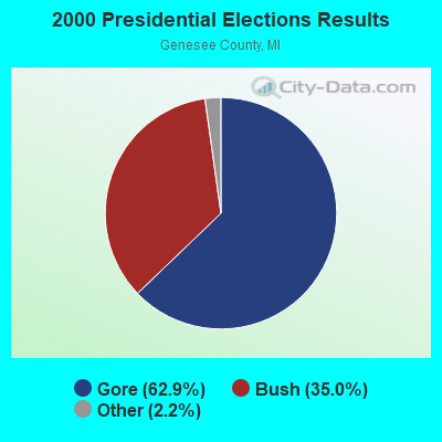
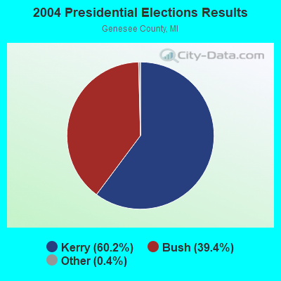
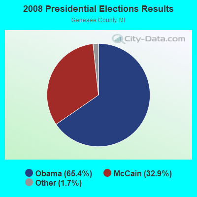

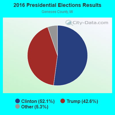
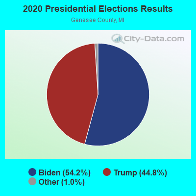
Graphs represent county-level data. Detailed 2008 Election Results
Religion statistics for Burton, MI (based on Genesee County data)

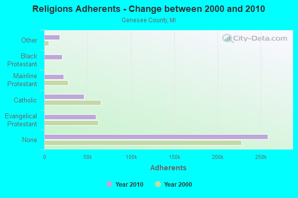
| Religion | Adherents | Congregations |
|---|---|---|
| Evangelical Protestant | 59,625 | 248 |
| Catholic | 45,566 | 25 |
| Mainline Protestant | 22,575 | 82 |
| Black Protestant | 20,768 | 60 |
| Other | 17,837 | 37 |
| Orthodox | 1,392 | 4 |
| None | 258,027 | - |
Food Environment Statistics:
| Genesee County: | 2.51 / 10,000 pop. |
| Michigan: | 2.34 / 10,000 pop. |
| This county: | 0.12 / 10,000 pop. |
| Michigan: | 0.18 / 10,000 pop. |
| Here: | 1.98 / 10,000 pop. |
| Michigan: | 1.52 / 10,000 pop. |
| Genesee County: | 3.04 / 10,000 pop. |
| Michigan: | 2.99 / 10,000 pop. |
| This county: | 5.67 / 10,000 pop. |
| State: | 6.80 / 10,000 pop. |
| Genesee County: | 11.3% |
| State: | 9.7% |
| Here: | 33.6% |
| Michigan: | 29.7% |
| This county: | 12.5% |
| Michigan: | 13.4% |
Health and Nutrition:
| Burton: | 50.0% |
| Michigan: | 50.3% |
| Burton: | 48.0% |
| Michigan: | 47.9% |
| Burton: | 28.8 |
| State: | 28.7 |
| Burton: | 20.3% |
| Michigan: | 20.6% |
| Burton: | 9.2% |
| Michigan: | 10.4% |
| Burton: | 6.8 |
| State: | 6.8 |
| Here: | 35.1% |
| State: | 34.1% |
| Burton: | 57.6% |
| Michigan: | 57.0% |
| This city: | 79.6% |
| State: | 79.6% |
More about Health and Nutrition of Burton, MI Residents
| Local government employment and payroll (March 2022) | |||||
| Function | Full-time employees | Monthly full-time payroll | Average yearly full-time wage | Part-time employees | Monthly part-time payroll |
|---|---|---|---|---|---|
| Police Protection - Officers | 35 | $193,991 | $66,511 | 0 | $0 |
| Financial Administration | 13 | $56,411 | $52,072 | 0 | $0 |
| Streets and Highways | 12 | $52,913 | $52,913 | 0 | $0 |
| Other Government Administration | 8 | $44,423 | $66,635 | 20 | $940 |
| Water Supply | 5 | $25,901 | $62,162 | 0 | $0 |
| Other and Unallocable | 4 | $18,892 | $56,676 | 0 | $0 |
| Sewerage | 3 | $13,915 | $55,660 | 0 | $0 |
| Fire - Other | 3 | $15,314 | $61,256 | 0 | $0 |
| Police - Other | 2 | $7,400 | $44,400 | 0 | $0 |
| Welfare | 2 | $9,794 | $58,764 | 1 | $669 |
| Parks and Recreation | 0 | $0 | 6 | $360 | |
| Firefighters | 0 | $0 | 33 | $13,720 | |
| Totals for Government | 87 | $438,953 | $60,545 | 60 | $15,689 |
Burton government finances - Expenditure in 2018 (per resident):
- Construction - Water Utilities: $5,099,000 ($173.15)
Sewerage: $661,000 ($22.45)
- Current Operations - Police Protection: $5,062,000 ($171.89)
Water Utilities: $4,917,000 ($166.97)
Sewerage: $4,266,000 ($144.86)
General - Other: $1,860,000 ($63.16)
Regular Highways: $1,654,000 ($56.16)
Solid Waste Management: $1,382,000 ($46.93)
General Public Buildings: $1,227,000 ($41.67)
Local Fire Protection: $978,000 ($33.21)
Central Staff Services: $890,000 ($30.22)
Financial Administration: $480,000 ($16.30)
Health - Other: $321,000 ($10.90)
Protective Inspection and Regulation - Other: $249,000 ($8.46)
Parks and Recreation: $174,000 ($5.91)
- General - Interest on Debt: $273,000 ($9.27)
- Intergovernmental to Local - Other - General - Other: $3,618,000 ($122.86)
Other - Sewerage: $3,385,000 ($114.94)
- Other Capital Outlay - Regular Highways: $684,000 ($23.23)
General - Other: $644,000 ($21.87)
Police Protection: $100,000 ($3.40)
Local Fire Protection: $32,000 ($1.09)
- Total Salaries and Wages: $5,180,000 ($175.90)
- Water Utilities - Interest on Debt: $543,000 ($18.44)
Burton government finances - Revenue in 2018 (per resident):
- Charges - Sewerage: $6,374,000 ($216.44)
Solid Waste Management: $1,382,000 ($46.93)
Other: $586,000 ($19.90)
- Federal Intergovernmental - Other: $1,656,000 ($56.23)
- Local Intergovernmental - Other: $264,000 ($8.96)
- Miscellaneous - Special Assessments: $1,577,000 ($53.55)
Donations From Private Sources: $1,119,000 ($38.00)
General Revenue - Other: $484,000 ($16.44)
Interest Earnings: $379,000 ($12.87)
Fines and Forfeits: $101,000 ($3.43)
Sale of Property: $50,000 ($1.70)
- Revenue - Water Utilities: $6,104,000 ($207.27)
- State Intergovernmental - Highways: $4,076,000 ($138.41)
General Local Government Support: $2,700,000 ($91.68)
Other: $100,000 ($3.40)
- Tax - Property: $7,487,000 ($254.24)
Occupation and Business License - Other: $432,000 ($14.67)
Other License: $148,000 ($5.03)
Burton government finances - Debt in 2018 (per resident):
- Long Term Debt - Outstanding Unspecified Public Purpose: $31,400,000 ($1066.25)
Beginning Outstanding - Unspecified Public Purpose: $30,232,000 ($1026.59)
Issue, Unspecified Public Purpose: $6,555,000 ($222.59)
Retired Unspecified Public Purpose: $5,387,000 ($182.93)
Burton government finances - Cash and Securities in 2018 (per resident):
- Other Funds - Cash and Securities: $22,805,000 ($774.39)
| Businesses in Burton, MI | ||||
| Name | Count | Name | Count | |
|---|---|---|---|---|
| 7-Eleven | 2 | MasterBrand Cabinets | 2 | |
| ALDI | 1 | McDonald's | 3 | |
| Advance Auto Parts | 1 | Meijer | 1 | |
| Applebee's | 1 | New Balance | 1 | |
| Bath & Body Works | 1 | Nike | 1 | |
| Burger King | 1 | OfficeMax | 1 | |
| Church's Chicken | 1 | Old Country Buffet | 1 | |
| Curves | 1 | Payless | 1 | |
| Dairy Queen | 2 | Penske | 1 | |
| Deb | 1 | RadioShack | 1 | |
| Discount Tire | 1 | Rite Aid | 5 | |
| Famous Footwear | 1 | SAS Shoes | 1 | |
| Fashion Bug | 1 | Sears | 1 | |
| FedEx | 3 | Sephora | 1 | |
| Finish Line | 1 | Sprint Nextel | 2 | |
| GNC | 3 | Staples | 1 | |
| GameStop | 1 | Subway | 5 | |
| H&R Block | 1 | T-Mobile | 1 | |
| Home Depot | 1 | Taco Bell | 2 | |
| JCPenney | 1 | Tim Hortons | 2 | |
| Kmart | 1 | U-Haul | 2 | |
| Kroger | 2 | UPS | 7 | |
| La-Z-Boy | 1 | Vans | 1 | |
| Lane Furniture | 1 | Verizon Wireless | 2 | |
| Little Caesars Pizza | 3 | Walmart | 1 | |
| Lowe's | 1 | Wendy's | 2 | |
Strongest AM radio stations in Burton:
- WFNT (1470 AM; 5 kW; FLINT, MI)
- WTRX (1330 AM; 5 kW; FLINT, MI; Owner: CITADEL BROADCASTING COMPANY)
- WWCK (1570 AM; 1 kW; FLINT, MI; Owner: CUMULUS LICENSING CORP.)
- WSNL (600 AM; 1 kW; FLINT, MI)
- WFLT (1420 AM; 0 kW; FLINT, MI; Owner: CHRISTIAN EVANGELICAL B/CASTING ASSO)
- WOAP (1080 AM; 50 kW; OWOSSO, MI)
- WWJ (950 AM; 50 kW; DETROIT, MI; Owner: INFINITY BROADCASTING OPERATIONS, INC.)
- WXYT (1270 AM; 50 kW; DETROIT, MI; Owner: INFINITY BROADCASTING CORP. OF DETROIT)
- WJR (760 AM; 50 kW; DETROIT, MI; Owner: ABC, INC.)
- WFDF (910 AM; 50 kW; FLINT, MI; Owner: ABC, INC.)
- WCHB (1200 AM; 50 kW; TAYLOR, MI; Owner: RADIO ONE OF DETROIT, LLC)
- WLSP (1530 AM; daytime; 5 kW; LAPEER, MI; Owner: REGENT BROADCASTING OF FLINT INC.)
- WDFN (1130 AM; 50 kW; DETROIT, MI; Owner: AMFM RADIO LICENSES, L.L.C.)
Strongest FM radio stations in Burton:
- WWCK-FM (105.5 FM; FLINT, MI; Owner: CUMULUS LICENSING CORP.)
- WDZZ-FM (92.7 FM; FLINT, MI; Owner: CUMULUS LICENSING CORP.)
- WFBE (95.1 FM; FLINT, MI; Owner: CITADEL BROADCASTING COMPANY)
- WCRZ (107.9 FM; FLINT, MI; Owner: REGENT BROADCASTING OF FLINT, INC.)
- WAKL (88.9 FM; FLINT, MI; Owner: EDUCATIONAL MEDIA FOUNDATION)
- WFUM-FM (91.1 FM; FLINT, MI; Owner: THE REGENTS OF THE UNIV. OF MICHIGAN)
- WTAC (89.7 FM; BURTON, MI; Owner: SUPERIOR COMMUNICATIONS)
- WHNN (96.1 FM; BAY CITY, MI; Owner: CITADEL BROADCASTING COMPANY)
- WWBN (101.5 FM; TUSCOLA, MI; Owner: REGENT BROADCASTING OF FLINT, INC.)
- WIOG (102.5 FM; BAY CITY, MI; Owner: CITADEL BROADCASTING COMPANY)
- WRIF (101.1 FM; DETROIT, MI; Owner: GREATER BOSTON RADIO, INC.)
- WRCL (93.7 FM; FRANKENMUTH, MI; Owner: REGENT BROADCASTING OF FLINT, INC.)
- WKRK-FM (97.1 FM; DETROIT, MI; Owner: INFINITY BROADCASTING OPERATIONS, INC.)
- WRSR (103.9 FM; OWOSSO, MI; Owner: CUMULUS LICENSING CORP.)
- WOWE (98.9 FM; VASSAR, MI; Owner: PRAESTANTIA BROADCASTING, INC.)
- WQUS (103.1 FM; LAPEER, MI; Owner: REGENT BROADCASTING OF FLINT INC.)
TV broadcast stations around Burton:
- WFUM (Channel 28; FLINT, MI; Owner: UNIVERSITY OF MICHIGAN)
- W09CK (Channel 9; FLINT, MI; Owner: P & P CABLE HOLDINGS, L.L.C.)
- WEYI-TV (Channel 25; SAGINAW, MI; Owner: WEYI BROADCASTING, LLC)
- W52CU (Channel 52; PINCONNING, MI; Owner: NTN/SAGINAW, INC.)
- WXON-LP (Channel 54; FLINT, MI; Owner: P & P CABLE HOLDINGS, L.L.C.)
- WSMH (Channel 66; FLINT, MI; Owner: WSMH LICENSEE, LLC)
- WAQP (Channel 49; SAGINAW, MI; Owner: TCT OF MICHIGAN, INC.)
- WJRT-TV (Channel 12; FLINT, MI; Owner: FLINT LICENSE SUBSIDIARY CORP.)
- WNEM-TV (Channel 5; BAY CITY, MI; Owner: MEREDITH CORPORATION)
- WXYZ-TV (Channel 7; DETROIT, MI; Owner: CHANNEL 7 OF DETROIT, INC.)
- WJBK (Channel 2; DETROIT, MI; Owner: FOX TELEVISION STATIONS, INC.)
- WKBD (Channel 50; DETROIT, MI; Owner: VIACOM STATIONS GROUP OF DETROIT INC.)
- WDIV-TV (Channel 4; DETROIT, MI; Owner: POST-NEWSWEEK STATIONS, MICHIGAN, INC.)
- WWJ-TV (Channel 62; DETROIT, MI; Owner: CBS BROADCASTING INC.)
- WDWB (Channel 20; DETROIT, MI; Owner: WXON LICENSE, INC.)
- WLNS-TV (Channel 6; LANSING, MI; Owner: YOUNG BROADCASTING OF LANSING, INC.)
- WTVS (Channel 56; DETROIT, MI; Owner: DETROIT EDUC. TV FOUNDATION)
- WKAR-TV (Channel 23; EAST LANSING, MI; Owner: BOARD OF TRUSTEES, MICH. STATE UNIV.)
- W22CC (Channel 22; PINCONNING, MI; Owner: P & P CABLE HOLDINGS, L.L.C.)
- W69DW (Channel 69; PINCONNING, MI; Owner: NTN/SAGINAW, INC.)
- National Bridge Inventory (NBI) Statistics
- 38Number of bridges
- 259ft / 78.9mTotal length
- $1,241,000Total costs
- 791,353Total average daily traffic
- 50,211Total average daily truck traffic
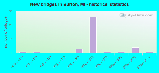
- New bridges - historical statistics
- 11920-1929
- 11930-1939
- 31960-1969
- 261970-1979
- 11980-1989
- 11990-1999
- 42000-2009
- 12010-2019
FCC Registered Commercial Land Mobile Towers: 1 (See the full list of FCC Registered Commercial Land Mobile Towers in Burton, MI)
FCC Registered Private Land Mobile Towers: 2 (See the full list of FCC Registered Private Land Mobile Towers)
FCC Registered Broadcast Land Mobile Towers: 19 (See the full list of FCC Registered Broadcast Land Mobile Towers)
FCC Registered Microwave Towers: 9 (See the full list of FCC Registered Microwave Towers in this town)
FCC Registered Paging Towers: 1 (See the full list of FCC Registered Paging Towers)
FCC Registered Amateur Radio Licenses: 117 (See the full list of FCC Registered Amateur Radio Licenses in Burton)
FAA Registered Aircraft Manufacturers and Dealers: 3 (See the full list of FAA Registered Manufacturers and Dealers in Burton)
FAA Registered Aircraft: 7 (See the full list of FAA Registered Aircraft)
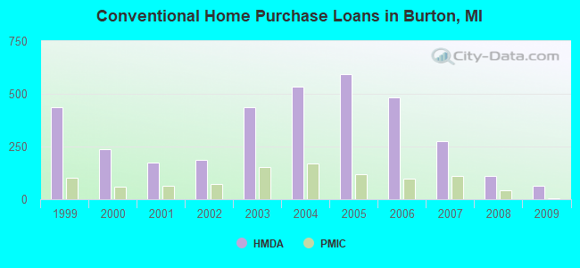
| Home Mortgage Disclosure Act Aggregated Statistics For Year 2009 (Based on 8 full tracts) | ||||||||||||
| A) FHA, FSA/RHS & VA Home Purchase Loans | B) Conventional Home Purchase Loans | C) Refinancings | D) Home Improvement Loans | F) Non-occupant Loans on < 5 Family Dwellings (A B C & D) | G) Loans On Manufactured Home Dwelling (A B C & D) | |||||||
|---|---|---|---|---|---|---|---|---|---|---|---|---|
| Number | Average Value | Number | Average Value | Number | Average Value | Number | Average Value | Number | Average Value | Number | Average Value | |
| LOANS ORIGINATED | 164 | $79,555 | 62 | $55,726 | 247 | $97,648 | 28 | $15,857 | 15 | $55,000 | 13 | $32,308 |
| APPLICATIONS APPROVED, NOT ACCEPTED | 14 | $95,929 | 8 | $50,875 | 36 | $108,250 | 7 | $8,143 | 3 | $31,333 | 3 | $35,667 |
| APPLICATIONS DENIED | 38 | $76,395 | 22 | $47,318 | 155 | $101,529 | 29 | $42,000 | 12 | $48,250 | 9 | $53,778 |
| APPLICATIONS WITHDRAWN | 22 | $74,727 | 9 | $322,667 | 78 | $107,833 | 3 | $35,333 | 7 | $385,857 | 3 | $886,000 |
| FILES CLOSED FOR INCOMPLETENESS | 7 | $75,143 | 1 | $44,000 | 7 | $85,857 | 1 | $6,000 | 0 | $0 | 0 | $0 |
Detailed HMDA statistics for the following Tracts: 0113.01 , 0113.02, 0114.01, 0114.02, 0115.02, 0115.03, 0115.05, 0115.08
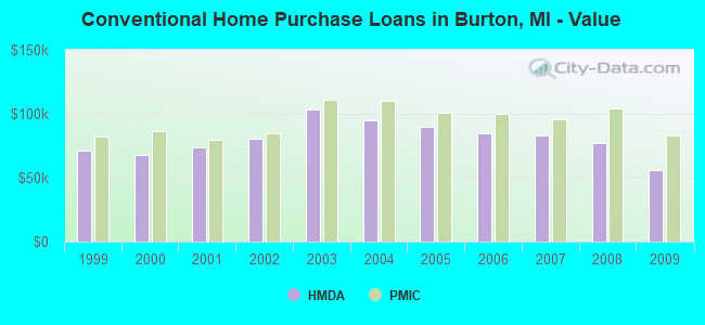
| Private Mortgage Insurance Companies Aggregated Statistics For Year 2009 (Based on 6 full tracts) | ||||
| A) Conventional Home Purchase Loans | B) Refinancings | |||
|---|---|---|---|---|
| Number | Average Value | Number | Average Value | |
| LOANS ORIGINATED | 6 | $83,167 | 2 | $99,500 |
| APPLICATIONS APPROVED, NOT ACCEPTED | 4 | $109,750 | 4 | $118,500 |
| APPLICATIONS DENIED | 2 | $92,500 | 4 | $112,500 |
| APPLICATIONS WITHDRAWN | 0 | $0 | 0 | $0 |
| FILES CLOSED FOR INCOMPLETENESS | 2 | $156,500 | 1 | $181,000 |
Detailed PMIC statistics for the following Tracts: 0113.01 , 0113.02, 0114.01, 0114.02, 0115.02, 0115.03, 0115.05, 0115.08
2002 - 2018 National Fire Incident Reporting System (NFIRS) incidents
- Fire incident types reported to NFIRS in Burton, MI
- 80954.5%Structure Fires
- 32021.6%Mobile Property/Vehicle Fires
- 30820.8%Outside Fires
- 473.2%Other
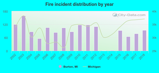 Based on the data from the years 2002 - 2018 the average number of fires per year is 87. The highest number of fires - 160 took place in 2003, and the least - 1 in 2013. The data has a decreasing trend.
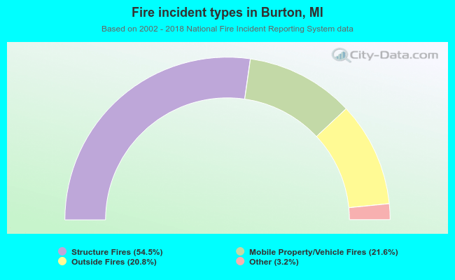 When looking into fire subcategories, the most incidents belonged to: Structure Fires (54.5%), and Mobile Property/Vehicle Fires (21.6%).
| Most common first names in Burton, MI among deceased individuals | ||
| Name | Count | Lived (average) |
|---|---|---|
| Mary | 163 | 78.6 years |
| Robert | 142 | 68.7 years |
| William | 141 | 74.3 years |
| James | 135 | 70.5 years |
| John | 115 | 73.9 years |
| Charles | 90 | 70.9 years |
| George | 74 | 73.2 years |
| Helen | 59 | 78.4 years |
| Joseph | 57 | 75.7 years |
| Dorothy | 53 | 77.4 years |
| Most common last names in Burton, MI among deceased individuals | ||
| Last name | Count | Lived (average) |
|---|---|---|
| Smith | 61 | 72.4 years |
| Johnson | 51 | 74.9 years |
| Jones | 36 | 76.1 years |
| Miller | 35 | 75.6 years |
| Williams | 33 | 73.9 years |
| Brown | 29 | 71.5 years |
| Thompson | 28 | 74.3 years |
| Allen | 23 | 75.2 years |
| Clark | 23 | 66.3 years |
| Thomas | 21 | 75.4 years |
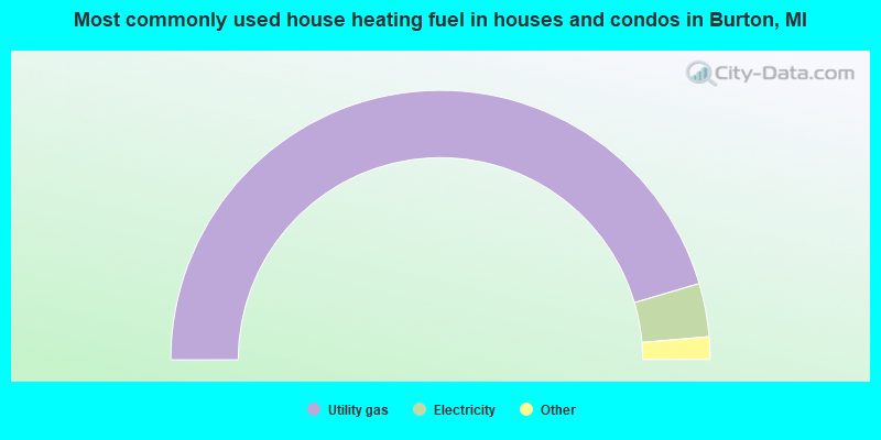
- 90.9%Utility gas
- 6.4%Electricity
- 1.3%Other fuel
- 0.9%Bottled, tank, or LP gas
- 0.5%Wood
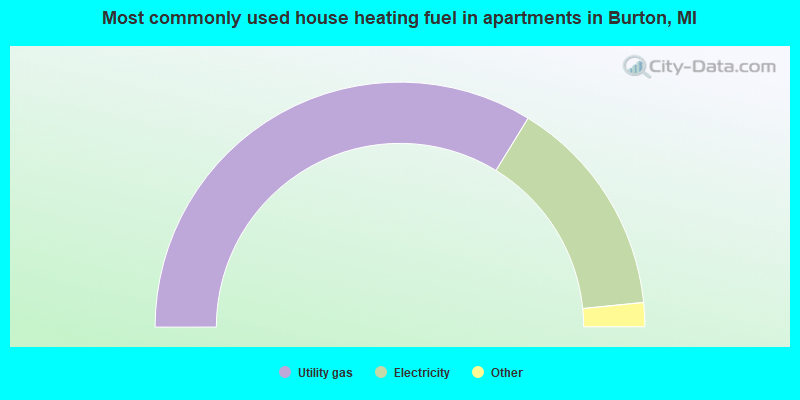
- 67.6%Utility gas
- 29.3%Electricity
- 1.3%No fuel used
- 1.1%Other fuel
- 0.7%Bottled, tank, or LP gas
Burton compared to Michigan state average:
- Median house value below state average.
- Unemployed percentage below state average.
- Foreign-born population percentage significantly below state average.
- Length of stay since moving in significantly above state average.
Burton on our top lists:
- #55 on the list of "Top 100 cities with lowest ratio of median house value to median household income (pop. 5,000+)"
- #69 on the list of "Top 101 cities with the highest number of arson incidents per 100,000 residents, excludes tourist destinations and others with a lot of outsiders visiting based on city industries data (population 5,000+)"
- #77 on the list of "Top 101 cities with the largest city-data.com crime index per police officer (population 5,000+)"
- #6 on the list of "Top 101 counties with the largest number of people moving out compared to moving in (pop. 50,000+)"
- #30 on the list of "Top 101 counties with the largest decrease in the number of infant deaths per 1000 residents 2000-2006 to 2007-2013 (pop. 50,000+)"
- #33 on the list of "Top 101 counties with the highest number of infant deaths per 1000 residents 2007-2013 (pop. 50,000+)"
- #34 on the list of "Top 101 counties with the lowest percentage of residents relocating from other counties between 2010 and 2011 (pop. 50,000+)"
- #40 on the list of "Top 101 counties with the lowest percentage of residents relocating from foreign countries between 2010 and 2011 (pop. 50,000+)"

|
|
Total of 36 patent applications in 2008-2024.