Calpet, Wyoming
Submit your own pictures of this place and show them to the world
- OSM Map
- General Map
- Google Map
- MSN Map

| Males: 6 | |
| Females: 3 |
| Median resident age: | 49.5 years |
| Wyoming median age: | 36.2 years |
| Calpet: | $114,333 |
| WY: | $70,042 |
Estimated per capita income in 2022: $44,865 (it was $17,067 in 2000)
Mean prices in 2022: all housing units: $576,940; detached houses: $606,052; mobile homes: $182,351


 Recent articles from our blog. Our writers, many of them Ph.D. graduates or candidates, create easy-to-read articles on a wide variety of topics.


Latest news from Calpet, WY collected exclusively by city-data.com from local newspapers, TV, and radio stations
Ancestries: Norwegian (100.0%), German (85.7%).
Current Local Time: MST time zone
Land area: 4.62 square miles.
Population density: 1.9 people per square mile (very low).

Nearest city with pop. 50,000+: Ogden, UT  (113.6 miles , pop. 77,226).
Nearest city with pop. 200,000+: Northeast Jefferson, CO (321.6 miles , pop. 450,166).
Nearest city with pop. 1,000,000+: Phoenix, AZ (613.5 miles , pop. 1,321,045).
Nearest cities:
), ), ), )Latitude: 42.28 N, Longitude: 110.27 W
Area code commonly used in this area: 307

| Here: | 3.0% |
| Wyoming: | 2.5% |
Average climate in Calpet, Wyoming
Based on data reported by over 4,000 weather stations


(lower is better)

Air Quality Index (AQI) level in 2022 was 44.8. This is significantly better than average.
| City: | 44.8 |
| U.S.: | 72.6 |

Nitrogen Dioxide (NO2) [ppb] level in 2022 was 0.922. This is significantly better than average. Closest monitor was 16.6 miles away from the city center.
| City: | 0.922 |
| U.S.: | 5.109 |

Ozone [ppb] level in 2022 was 35.7. This is about average. Closest monitor was 16.6 miles away from the city center.
| City: | 35.7 |
| U.S.: | 33.3 |

Particulate Matter (PM10) [µg/m3] level in 2013 was 8.70. This is significantly better than average. Closest monitor was 16.6 miles away from the city center.
| City: | 8.70 |
| U.S.: | 19.21 |

Particulate Matter (PM2.5) [µg/m3] level in 2013 was 4.05. This is significantly better than average. Closest monitor was 16.6 miles away from the city center.
| City: | 4.05 |
| U.S.: | 8.11 |
Earthquake activity:
Calpet-area historical earthquake activity is significantly above Wyoming state average. It is 1559% greater than the overall U.S. average.On 8/18/1959 at 06:37:13, a magnitude 7.7 (7.7 UK, Class: Major, Intensity: VIII - XII) earthquake occurred 159.0 miles away from the city center, causing $26,000,000 total damage
On 10/28/1983 at 14:06:06, a magnitude 7.3 (6.2 MB, 7.3 MS, 7.0 MW) earthquake occurred 216.9 miles away from the city center, causing 2 deaths (2 shaking deaths) and 3 injuries, causing $15,000,000 total damage
On 10/3/1915 at 06:52:48, a magnitude 7.6 (7.6 UK) earthquake occurred 394.6 miles away from the city center
On 3/28/1975 at 02:31:05, a magnitude 6.2 (6.1 MB, 6.0 MS, 6.2 ML, Class: Strong, Intensity: VII - IX) earthquake occurred 114.5 miles away from the city center
On 2/3/1994 at 09:05:04, a magnitude 5.8 (5.4 MB, 5.5 MS, 5.8 MW, 5.8 ML, Depth: 4.9 mi, Class: Moderate, Intensity: VI - VII) earthquake occurred 49.1 miles away from Calpet center
On 6/30/1975 at 18:54:13, a magnitude 6.1 (5.6 MB, 5.9 MS, 6.1 UK, 6.1 ML) earthquake occurred 166.9 miles away from Calpet center
Magnitude types: body-wave magnitude (MB), local magnitude (ML), surface-wave magnitude (MS), moment magnitude (MW)
Natural disasters:
The number of natural disasters in Sublette County (2) is a lot smaller than the US average (15).Emergencies Declared: 1
Causes of natural disasters: Drought: 1, Other: 1 (Note: some incidents may be assigned to more than one category).

Colleges/universities with over 2000 students nearest to Calpet:
- Western Wyoming Community College (about 72 miles; Rock Springs, WY; Full-time enrollment: 2,086)
- Utah State University (about 88 miles; Logan, UT; FT enrollment: 21,131)
- Weber State University (about 115 miles; Ogden, UT; FT enrollment: 17,655)
- Idaho State University (about 117 miles; Pocatello, ID; FT enrollment: 10,350)
- Brigham Young University-Idaho (about 131 miles; Rexburg, ID; FT enrollment: 30,522)
- University of Utah (about 134 miles; Salt Lake City, UT; FT enrollment: 28,454)
- Latter-day Saints Business College (about 135 miles; Salt Lake City, UT; FT enrollment: 2,059)
Points of interest:
Creek: Cedar Creek (A). Display/hide its location on the map
| This place: | 2.3 people |
| Wyoming: | 2.5 people |
| This place: | 66.7% |
| Whole state: | 67.9% |
| This place: | 0.0% |
| Whole state: | 5.4% |
No gay or lesbian households reported
For population 15 years and over in Calpet:

- Never married: 44.4%
- Now married: 55.6%
- Separated: 0.0%
- Widowed: 0.0%
- Divorced: 0.0%
For population 25 years and over in Calpet:
- High school or higher: 100.0%
- Bachelor's degree or higher: 0.0%
- Graduate or professional degree: 0.0%
- Mean travel time to work (commute): 10.0 minutes


| Here: | 3.6 |
| Wyoming average: | 10.0 |
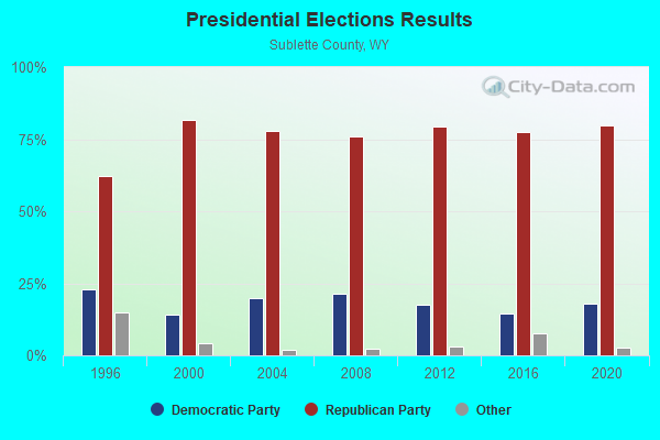
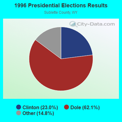
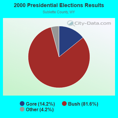
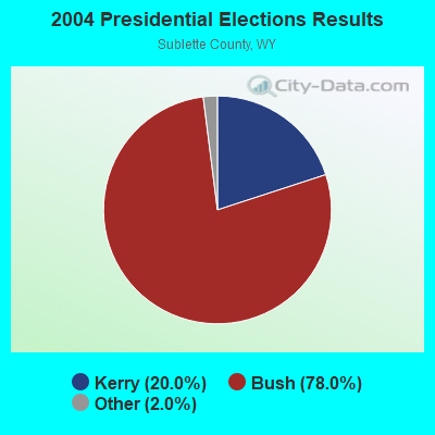
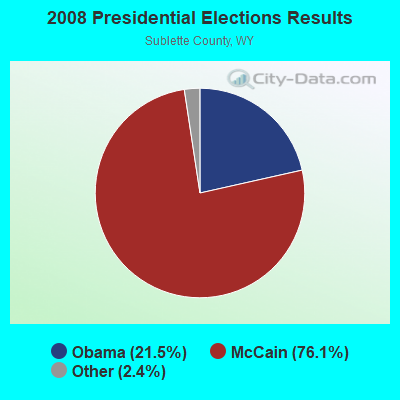
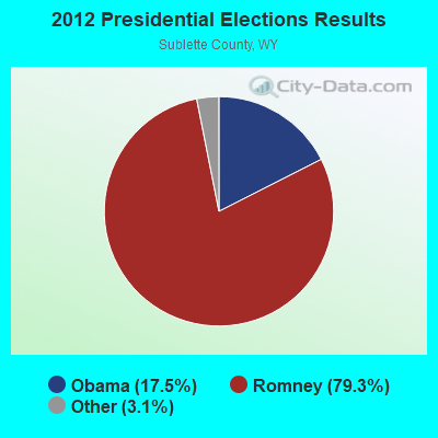
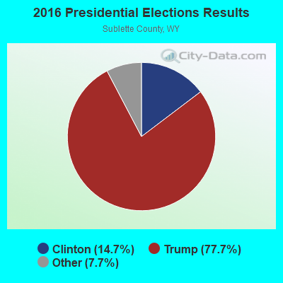
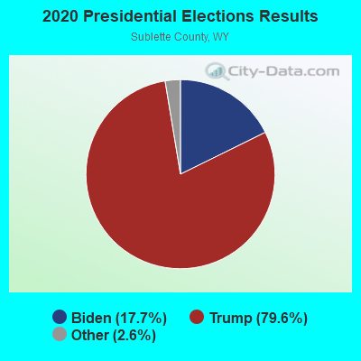
Graphs represent county-level data. Detailed 2008 Election Results
Religion statistics for Calpet, WY (based on Sublette County data)
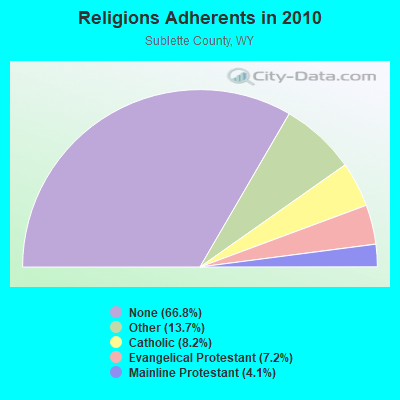
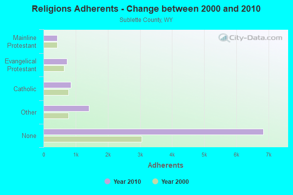
| Religion | Adherents | Congregations |
|---|---|---|
| Other | 1,408 | 3 |
| Catholic | 844 | 2 |
| Evangelical Protestant | 734 | 9 |
| Mainline Protestant | 420 | 4 |
| None | 6,841 | - |
Food Environment Statistics:
| This county: | 2.52 / 10,000 pop. |
| Wyoming: | 2.10 / 10,000 pop. |
| Sublette County: | 1.26 / 10,000 pop. |
| State: | 0.65 / 10,000 pop. |
| Sublette County: | 8.81 / 10,000 pop. |
| Wyoming: | 5.36 / 10,000 pop. |
| Sublette County: | 16.36 / 10,000 pop. |
| Wyoming: | 10.08 / 10,000 pop. |
| Sublette County: | 5.6% |
| Wyoming: | 7.1% |
| This county: | 23.7% |
| State: | 24.4% |
Strongest AM radio stations in Calpet:
- KALL (700 AM; 50 kW; NORTH SALT LAKE CITY, UT; Owner: CITICASTERS LICENSES, L.P.)
- KMER (950 AM; 5 kW; KEMMERER, WY; Owner: CHAPARRAL BROADCASTING, INC.)
- KIQN (1010 AM; 50 kW; TOOELE, UT)
- KSL (1160 AM; 50 kW; SALT LAKE CITY, UT; Owner: BONNEVILLE HOLDING COMPANY)
- KRSV (1210 AM; 5 kW; AFTON, WY; Owner: WESTERN WYOMING RADIO, INC.)
- KBRV (790 AM; 5 kW; SODA SPRINGS, ID; Owner: CARIBOU BROADCASTING INC.)
- KSOS (800 AM; 10 kW; BRIGHAM CITY, UT; Owner: SIMMONS-SLC, LS, LLC)
- KTWO (1030 AM; 50 kW; CASPER, WY; Owner: CITICASTERS LICENSES, L.P.)
- KZNR (690 AM; 10 kW; BLACKFOOT, ID; Owner: WESTERN COMMUNICATIONS, INC.)
- KVNU (610 AM; 5 kW; LOGAN, UT; Owner: SUN VALLEY RADIO,INC.)
- KTKK (630 AM; 10 kW; SANDY, UT; Owner: UNITED BROADCASTING COMPANY)
- KRKK (1360 AM; 5 kW; ROCK SPRINGS, WY; Owner: BIG THICKET B/CING CO. OF WY, INC.)
- KNZZ (1100 AM; 50 kW; GRAND JUNCTION, CO; Owner: M B C GRAND BROADCASTING, INC.)
Strongest FM radio stations in Calpet:
- K296AT (107.1 FM; LA BARGE, WY; Owner: WESTERN INSPIRATIONAL BROADCASTERS, INC)
- KDWY (105.3 FM; DIAMONDVILLE, WY; Owner: JERROLD T. LUNDQUIST)
- KAOX (107.3 FM; KEMMERER, WY; Owner: JERROLD T. LUNDQUIST)
TV broadcast stations around Calpet:
- K59BV (Channel 59; LAVA HOT SPRINGS, ID; Owner: STATE BOARD OF EDUCATION (IEPBS))
- K02GE (Channel 2; LA BARGE, WY; Owner: TULSA T. V. ASSOCIATION)
- K09IJ (Channel 9; LA BARGE, WY; Owner: TULSA T. V. ASSOCIATION)
- K62CS (Channel 62; LA BARGE, WY; Owner: HICKEY MOUNTAIN TV ASSOCIATION)
Calpet fatal accident list:
FCC Registered Cell Phone Towers:
1- Hogsback Ridge, 6.7 Km Nw Of (Lat: 42.325250 Lon: -110.319639), Type: Tower, Structure height: 24 m, Call Sign: KNKN259
Assigned Frequencies: 880.020 MHz, 880.020 MHz, 835.020 MHz, 835.020 MHz, 891.510 MHz, 891.510 MHz, 846.510 MHz, 846.510 MHz, 880.020 MHz, 835.020 MHz, 891.510 MHz, 846.510 MHzGrant Date: 09/04/2019, Expiration Date: 10/05/2029Registrant: Lukas, Lafuria, Gutierrez & Sachs, LLP, 8300 Greensboro Drive, Suite 1200, Tysons, VA 22102, Phone: (703) 584-8673, Fax: (703) 584-8696, Email:
FCC Registered Microwave Towers:
11 (See the full list of FCC Registered Microwave Towers in this town)Calpet compared to Wyoming state average:
- Median household income above state average.
- Median house value significantly below state average.
- Unemployed percentage significantly below state average.
- Black race population percentage significantly below state average.
- Hispanic race population percentage significantly below state average.
- Median age above state average.
- Foreign-born population percentage significantly below state average.
- Renting percentage significantly below state average.
- Length of stay since moving in significantly above state average.
- Number of rooms per house significantly below state average.
- House age significantly below state average.
- Number of college students significantly below state average.
- Percentage of population with a bachelor's degree or higher significantly below state average.