Campaign, Tennessee
Submit your own pictures of this place and show them to the world
- OSM Map
- General Map
- Google Map
- MSN Map

| Males: 1,924 | |
| Females: 1,864 |
| Median resident age: | 36.2 years |
| Tennessee median age: | 35.9 years |
Zip code: 38581
| Campaign: | $61,227 |
| TN: | $65,254 |
Estimated per capita income in 2022: $25,721 (it was $14,709 in 2000)
Campaign CCD income, earnings, and wages data
Estimated median house or condo value in 2022: $172,619 (it was $68,600 in 2000)
| Campaign: | $172,619 |
| TN: | $284,800 |
Mean prices in 2022: all housing units: $225,904; detached houses: $243,679; townhouses or other attached units: $185,780; in 2-unit structures: $68,491; mobile homes: $72,535
Detailed information about poverty and poor residents in Campaign, TN


- 3,33791.5%White alone
- 1865.1%Hispanic
- 952.6%Black alone
- 190.5%Two or more races
- 70.2%American Indian alone
- 20.05%Asian alone
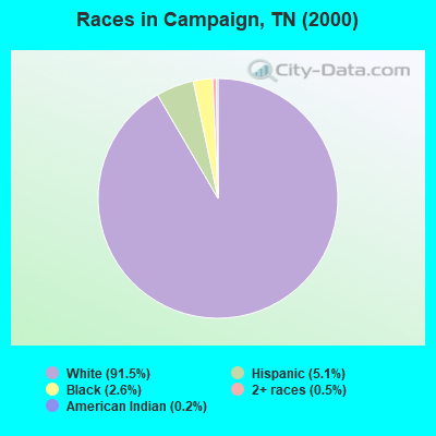
Races in Campaign detailed stats: ancestries, foreign born residents, place of birth
 Recent articles from our blog. Our writers, many of them Ph.D. graduates or candidates, create easy-to-read articles on a wide variety of topics.

Current Local Time: CST time zone
Elevation: 965 feet
Land area: 61.7 square miles.
Population density: 61 people per square mile (very low).

| Campaign CCD: | 0.5% ($338) |
| Tennessee: | 0.8% ($715) |
Nearest city with pop. 50,000+: Murfreesboro, TN  (42.0 miles , pop. 68,816).
Nearest city with pop. 200,000+: Nashville-Davidson, TN (68.0 miles , pop. 545,524).
Nearest city with pop. 1,000,000+: Chicago, IL (435.6 miles , pop. 2,896,016).
Nearest cities:
), ), ), ), )Latitude: 35.74 N, Longitude: 85.66 W
Area code commonly used in this area: 931

| Here: | 3.3% |
| Tennessee: | 3.0% |
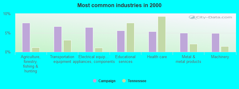
- Agriculture, forestry, fishing & hunting (7.6%)
- Transportation equipment (6.6%)
- Electrical equipment, appliances, components (6.4%)
- Educational services (5.6%)
- Health care (5.3%)
- Metal & metal products (5.0%)
- Machinery (4.9%)
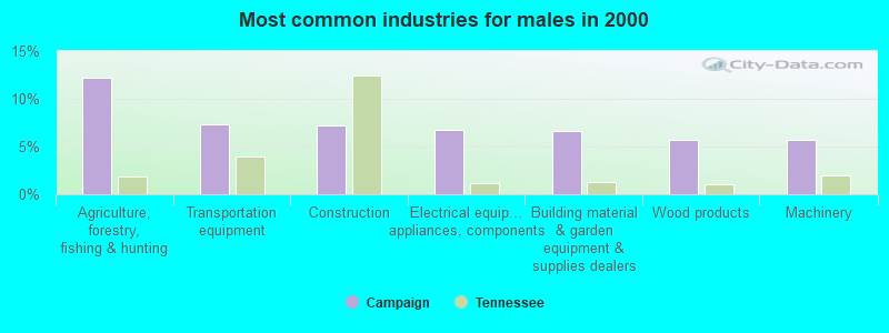
- Agriculture, forestry, fishing & hunting (12.2%)
- Transportation equipment (7.3%)
- Construction (7.2%)
- Electrical equipment, appliances, components (6.7%)
- Building material & garden equipment & supplies dealers (6.6%)
- Wood products (5.7%)
- Machinery (5.7%)
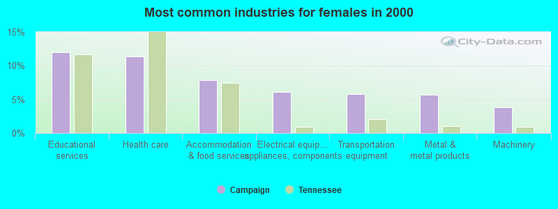
- Educational services (12.0%)
- Health care (11.4%)
- Accommodation & food services (7.9%)
- Electrical equipment, appliances, components (6.1%)
- Transportation equipment (5.8%)
- Metal & metal products (5.7%)
- Machinery (3.8%)
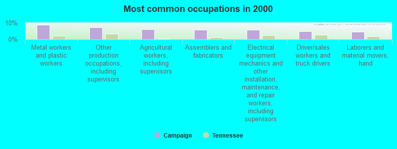
- Metal workers and plastic workers (8.9%)
- Other production occupations, including supervisors (7.1%)
- Agricultural workers, including supervisors (6.0%)
- Assemblers and fabricators (5.8%)
- Electrical equipment mechanics and other installation, maintenance, and repair workers, including supervisors (5.7%)
- Driver/sales workers and truck drivers (4.9%)
- Laborers and material movers, hand (4.5%)
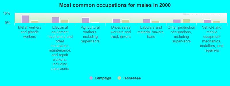
- Metal workers and plastic workers (12.5%)
- Electrical equipment mechanics and other installation, maintenance, and repair workers, including supervisors (9.5%)
- Agricultural workers, including supervisors (8.9%)
- Driver/sales workers and truck drivers (6.9%)
- Laborers and material movers, hand (6.2%)
- Other production occupations, including supervisors (5.6%)
- Vehicle and mobile equipment mechanics, installers, and repairers (5.4%)
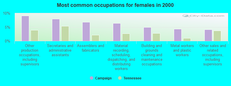
- Other production occupations, including supervisors (9.0%)
- Secretaries and administrative assistants (7.9%)
- Assemblers and fabricators (6.8%)
- Material recording, scheduling, dispatching, and distributing workers (6.4%)
- Building and grounds cleaning and maintenance occupations (4.9%)
- Metal workers and plastic workers (4.3%)
- Other sales and related occupations, including supervisors (4.1%)
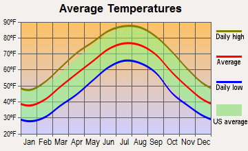
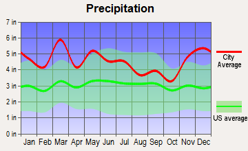
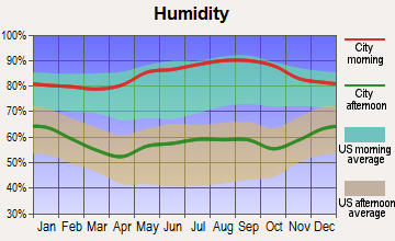
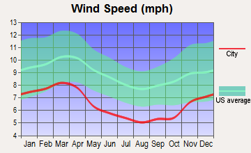
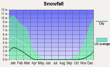
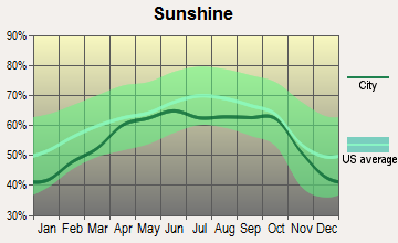
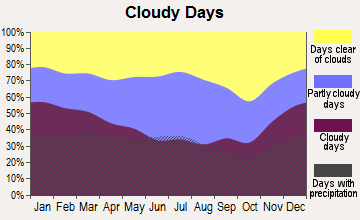
Average climate in Campaign, Tennessee
Based on data reported by over 4,000 weather stations
(lower is better)
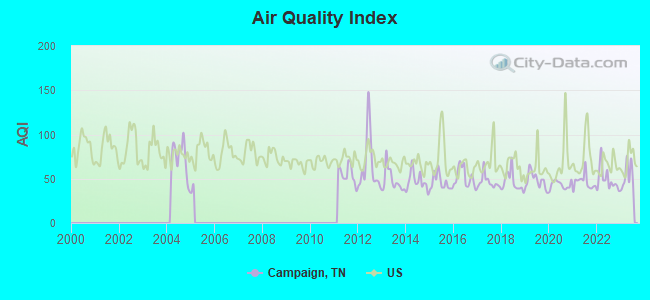
Air Quality Index (AQI) level in 2023 was 52.8. This is better than average.
| City: | 52.8 |
| U.S.: | 72.6 |
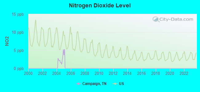
Nitrogen Dioxide (NO2) [ppb] level in 2004 was 2.46. This is significantly better than average. Closest monitor was 22.8 miles away from the city center.
| City: | 2.46 |
| U.S.: | 5.11 |
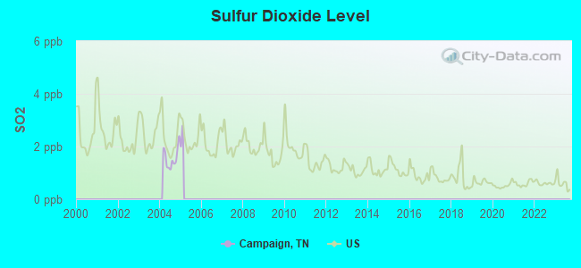
Sulfur Dioxide (SO2) [ppb] level in 2004 was 1.58. This is about average. Closest monitor was 22.8 miles away from the city center.
| City: | 1.58 |
| U.S.: | 1.51 |
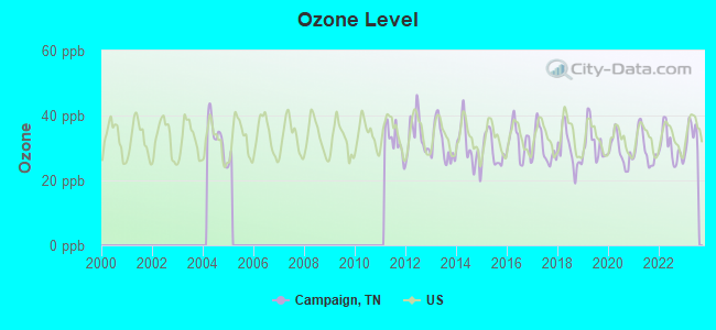
Ozone [ppb] level in 2023 was 33.7. This is about average. Closest monitor was 21.0 miles away from the city center.
| City: | 33.7 |
| U.S.: | 33.3 |
Tornado activity:
Campaign-area historical tornado activity is near Tennessee state average. It is 52% greater than the overall U.S. average.
On 4/3/1974, a category F5 (max. wind speeds 261-318 mph) tornado 25.4 miles away from the Campaign place center killed 16 people and injured 190 people.
On 4/3/1974, a category F4 (max. wind speeds 207-260 mph) tornado 20.6 miles away from the place center killed 10 people and injured 51 people and caused between $500,000 and $5,000,000 in damages.
Earthquake activity:
Campaign-area historical earthquake activity is significantly above Tennessee state average. It is 140% greater than the overall U.S. average.On 4/29/2003 at 08:59:39, a magnitude 4.9 (4.4 MB, 4.6 MW, 4.9 LG, Class: Light, Intensity: IV - V) earthquake occurred 86.3 miles away from the city center
On 4/18/2008 at 09:36:59, a magnitude 5.4 (5.1 MB, 4.8 MS, 5.4 MW, 5.2 MW, Class: Moderate, Intensity: VI - VII) earthquake occurred 224.1 miles away from Campaign center
On 7/27/1980 at 18:52:21, a magnitude 5.2 (5.1 MB, 4.7 MS, 5.0 UK, 5.2 UK) earthquake occurred 195.0 miles away from Campaign center
On 11/30/1973 at 07:48:41, a magnitude 4.7 (4.7 MB, 4.6 ML) earthquake occurred 95.4 miles away from Campaign center
On 4/29/2003 at 08:59:39, a magnitude 4.6 (4.6 MW, Depth: 12.3 mi) earthquake occurred 86.3 miles away from the city center
On 12/12/2018 at 09:14:43, a magnitude 4.4 (4.4 MW, Depth: 4.9 mi) earthquake occurred 52.9 miles away from the city center
Magnitude types: regional Lg-wave magnitude (LG), body-wave magnitude (MB), local magnitude (ML), surface-wave magnitude (MS), moment magnitude (MW)
Natural disasters:
The number of natural disasters in Warren County (17) is near the US average (15).Major Disasters (Presidential) Declared: 13
Emergencies Declared: 2
Causes of natural disasters: Floods: 9, Storms: 9, Tornadoes: 5, Winter Storms: 4, Flash Flood: 1, Heavy Rain: 1, Hurricane: 1, Ice Storm: 1, Landslide: 1, Mudslide: 1, Snowfall: 1, Wind: 1, Other: 1 (Note: some incidents may be assigned to more than one category).
Hospitals and medical centers near Campaign:
- RIVER PARK HOSPITAL Acute Care Hospitals (about 6 miles away; MC MINNVILLE, TN)
- MCMINNVILLE DIALYSIS CLINIC (Dialysis Facility, about 6 miles away; MCMINNVILLE, TN)
- WARREN REGIONAL HOSPITAL (Hospital, about 6 miles away; MC MINNVILLE, TN)
- RCG MCMINNVILLE (Dialysis Facility, about 6 miles away; MCMINNVILLE, TN)
- RAINTREE MANOR (Nursing Home, about 6 miles away; MC MINNVILLE, TN)
- INTREPID USA HEALTHCARE SERVICES (Home Health Center, about 7 miles away; MC MINNVILLE, TN)
- CAREALL HOME CARE SERVICES (Home Health Center, about 8 miles away; MC MINNVILLE, TN)
Colleges/universities with over 2000 students nearest to Campaign:
- Tennessee Technological University (about 32 miles; Cookeville, TN; Full-time enrollment: 9,761)
- Middle Tennessee State University (about 41 miles; Murfreesboro, TN; FT enrollment: 21,628)
- Motlow State Community College (about 45 miles; Tullahoma, TN; FT enrollment: 2,915)
- Chattanooga State Community College (about 51 miles; Chattanooga, TN; FT enrollment: 6,827)
- The University of Tennessee-Chattanooga (about 53 miles; Chattanooga, TN; FT enrollment: 10,158)
- Cleveland State Community College (about 58 miles; Cleveland, TN; FT enrollment: 2,500)
- Southern Adventist University (about 59 miles; Collegedale, TN; FT enrollment: 2,898)
Points of interest:
Notable locations in Campaign: Rock Station (A), Camp Overton (B), Campaign - Rock Island Volunteer Fire Department (C). Display/hide their locations on the map
Churches in Campaign include: Eureka Church (A), Mount View Church (B), Mount Vernon Church (C), Shiloh Church (D), Jericho Church (E), Friendship Church (F), Pleasant Cove Church (G), Bethlehem Church (H), Pine Bluff Church (I). Display/hide their locations on the map
Cemeteries: Mount Vernon Cemetery (1), New Rocky Cemetery (2), O'Neal Cemetery (3), Rock Island Cemetery (4), Friendship Cemetery (5). Display/hide their locations on the map
Lake: Lake Karen (A). Display/hide its location on the map
Streams, rivers, and creeks: Dry Branch (A), Dark Hollow Branch (B), Collins River (C), Cane Hollow Branch (D), Mud Creek (E), Rocky River (F), Rams Creek (G), Powder Mill Branch (H). Display/hide their locations on the map
| This place: | 2.6 people |
| Tennessee: | 2.5 people |
| This place: | 65.8% |
| Whole state: | 69.8% |
| This place: | 4.3% |
| Whole state: | 4.2% |
Likely homosexual households (counted as self-reported same-sex unmarried-partner households)
- Lesbian couples: 0.1% of all households
- Gay men: 0.1% of all households
| This place: | 9.4% |
| Whole state: | 13.5% |
| This place: | 3.9% |
| Whole state: | 5.8% |
People in group quarters in Campaign in 2000:
- 43 people in agriculture workers' dormitories on farms
- 15 people in homes for the mentally ill
- 5 people in other noninstitutional group quarters
For population 15 years and over in Campaign:
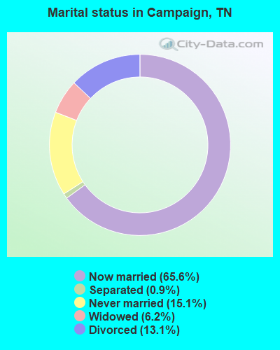
- Never married: 15.1%
- Now married: 65.6%
- Separated: 0.9%
- Widowed: 6.2%
- Divorced: 13.1%
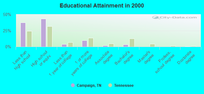
For population 25 years and over in Campaign:
- High school or higher: 62.7%
- Bachelor's degree or higher: 4.0%
- Graduate or professional degree: 0.8%
- Unemployed: 5.2%
- Mean travel time to work (commute): 22.0 minutes
| Here: | 12.9 |
| Tennessee average: | 13.3 |
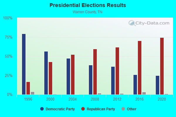
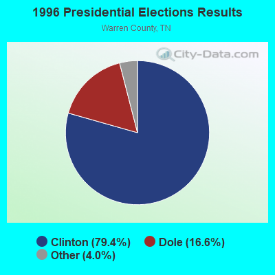
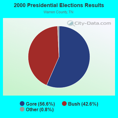
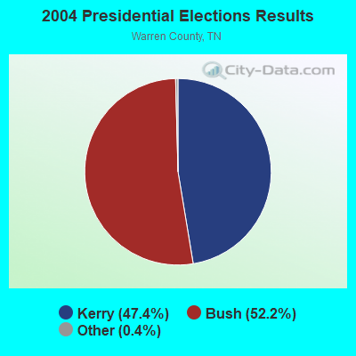
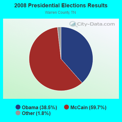
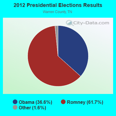
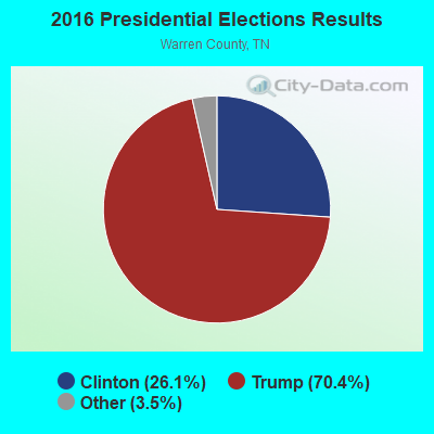
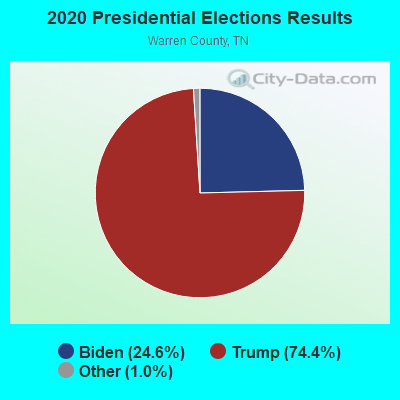
Graphs represent county-level data. Detailed 2008 Election Results
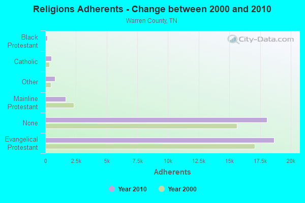
Religion statistics for Campaign, TN (based on Warren County data)
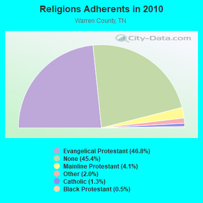
| Religion | Adherents | Congregations |
|---|---|---|
| Evangelical Protestant | 18,657 | 107 |
| Mainline Protestant | 1,638 | 12 |
| Other | 784 | 4 |
| Catholic | 500 | 1 |
| Black Protestant | 185 | 1 |
| None | 18,075 | - |
Food Environment Statistics:
| This county: | 3.28 / 10,000 pop. |
| Tennessee: | 1.99 / 10,000 pop. |
| Warren County: | 0.25 / 10,000 pop. |
| State: | 0.17 / 10,000 pop. |
| Warren County: | 0.76 / 10,000 pop. |
| Tennessee: | 0.65 / 10,000 pop. |
| Warren County: | 5.30 / 10,000 pop. |
| State: | 5.16 / 10,000 pop. |
| Warren County: | 5.80 / 10,000 pop. |
| Tennessee: | 6.56 / 10,000 pop. |
| Here: | 10.7% |
| Tennessee: | 11.4% |
| Warren County: | 31.7% |
| State: | 30.2% |
| Warren County: | 9.3% |
| Tennessee: | 13.5% |
Strongest AM radio stations in Campaign:
- WWAM (820 AM; daytime; 50 kW; JASPER, TN; Owner: SHELTON BROADCASTING SYSTEM)
- WFLI (1070 AM; 50 kW; LOOKOUT MOUNTAIN, TN; Owner: WFLI, INC.)
- WSM (650 AM; 50 kW; NASHVILLE, TN; Owner: GAYLORD ENTERTAINMENT COMPANY)
- WAKI (1230 AM; 1 kW; MCMINNVILLE, TN; Owner: CITICASTERS LICENSES, L.P.)
- WAMB (1160 AM; 50 kW; DONELSON, TN; Owner: GREAT SOUTHERN BROADCASTING COMPANY, INC.)
- WBMC (960 AM; 0 kW; MCMINNVILLE, TN; Owner: CITICASTERS LICENSES, L.P.)
- WKDA (1200 AM; 50 kW; NASHVILLE, TN; Owner: RADIO NASHVILLE, INC.)
- WNQM (1300 AM; 50 kW; NASHVILLE, TN; Owner: WNQM. INC.)
- WLAC (1510 AM; 50 kW; NASHVILLE, TN; Owner: CAPSTAR TX LIMITED PARTNERSHIP)
- WKVL (850 AM; daytime; 50 kW; KNOXVILLE, TN; Owner: HORNE RADIO, LLC)
- WSDQ (1190 AM; daytime; 5 kW; DUNLAP, TN; Owner: RODGSON, INC.)
- WLOR (1550 AM; 50 kW; HUNTSVILLE, AL; Owner: BCA RADIO, LLC)
- WMSR (1320 AM; 5 kW; MANCHESTER, TN; Owner: COFFEE COUNTY BROADCASTING, INC.)
Strongest FM radio stations in Campaign:
- WKZP (107.3 FM; SPENCER, TN; Owner: CITICASTERS LICENSES, L.P.)
- WZYZ (90.1 FM; SPENCER, TN; Owner: CHURCH FAITH TRINITY ASSEMBLIES)
- W211AS (90.1 FM; SPENCER, TN; Owner: AMERICAN FAMILY ASSOCIATION)
- WTRZ-FM (103.9 FM; MCMINNVILLE, TN; Owner: CITICASTERS LICENSES, L.P.)
- WRKK-FM (105.5 FM; SPARTA, TN; Owner: CLEAR CHANNEL BROADCASTING LICENSES, INC.)
- WGSQ (94.7 FM; COOKEVILLE, TN; Owner: CLEAR CHANNEL BROADCASTING LICENSES, INC.)
- WMKW (89.3 FM; CROSSVILLE, TN; Owner: THE MOODY BIBLE INSTITUTE OF CHICAGO)
- WUSY (100.7 FM; CLEVELAND, TN; Owner: CAPSTAR TX LIMITED PARTNERSHIP)
- WWTN (99.7 FM; MANCHESTER, TN; Owner: CUMULUS LICENSING CORP.)
- W219AD (91.7 FM; SPARTA, ETC., TN; Owner: HICKORY NUT MTN RADIO FELLOWSHIP)
- WDEF-FM (92.3 FM; CHATTANOOGA, TN; Owner: JACKSON TELECASTERS, INC.)
- WSMC-FM (90.5 FM; COLLEGEDALE, TN; Owner: SOUTHERN COLLEGE OF SEVENTH-DAY ADVT)
- WDOD-FM (96.5 FM; CHATTANOOGA, TN; Owner: WDOD OF CHATTANOOGA, INC.)
- WSKZ (106.5 FM; CHATTANOOGA, TN; Owner: CITADEL BROADCASTING COMPANY)
- WKXD-FM (106.9 FM; MONTEREY, TN; Owner: JWC BROADCASTING)
- WOWF (102.5 FM; CROSSVILLE, TN; Owner: PEG BROADCASTING, INC.)
- WSGM (104.7 FM; COALMONT, TN; Owner: CUMBERLAND COMMUNICATION CORPORATION)
- W299AE (107.7 FM; MCMINNVILLE, TN; Owner: CITICASTERS LICENSES, L.P.)
- WWOG (90.9 FM; COOKEVILLE, TN; Owner: SOMERSET EDUCATIONAL BROADCASTING FOUNDATION)
- WGIC (98.5 FM; COOKEVILLE, TN; Owner: CLEAR CHANNEL BROADCASTING LICENSES, INC.)
TV broadcast stations around Campaign:
- WFLI-TV (Channel 53; CLEVELAND, TN; Owner: CHATTANOOGA MEDIA HOLDINGS, L.L.C.)
- WCTE (Channel 22; COOKEVILLE, TN; Owner: UPPER CUMBERLAND BROADCAST COUNCIL)
- WBXX-TV (Channel 20; CROSSVILLE, TN; Owner: ACME TV LICENSES OF TENNESSEE, LLC)
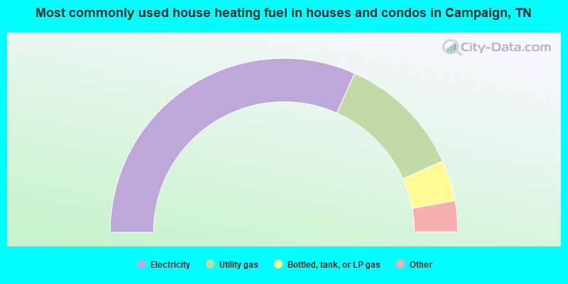
- 63.4%Electricity
- 23.3%Utility gas
- 7.6%Bottled, tank, or LP gas
- 3.3%Fuel oil, kerosene, etc.
- 2.5%Wood
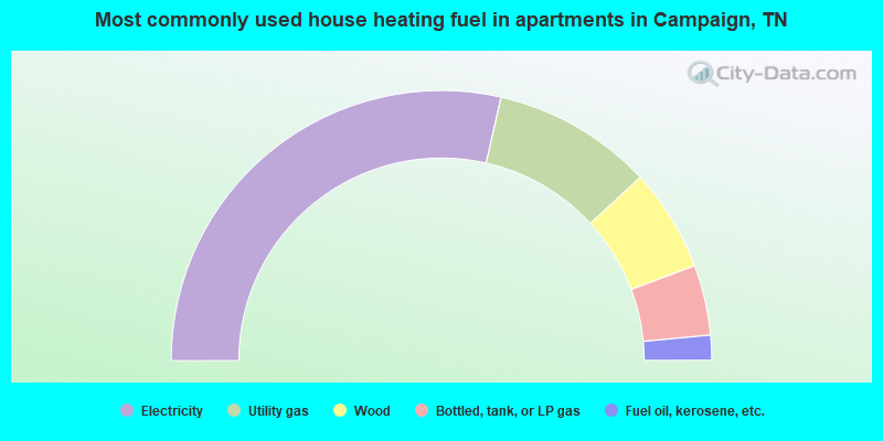
- 57.1%Electricity
- 19.2%Utility gas
- 12.3%Wood
- 8.4%Bottled, tank, or LP gas
- 3.0%Fuel oil, kerosene, etc.
Campaign compared to Tennessee state average:
- Median house value below state average.
- Unemployed percentage below state average.
- Black race population percentage significantly below state average.
- Foreign-born population percentage significantly below state average.
- Renting percentage significantly below state average.
- Length of stay since moving in significantly above state average.
- Number of rooms per house significantly below state average.
- House age significantly below state average.
- Number of college students below state average.
- Percentage of population with a bachelor's degree or higher significantly below state average.
Campaign on our top lists:
- #79 on the list of "Top 101 cities with the largest percentage of people in agriculture workers' dormitories on farms (population 1,000+)"