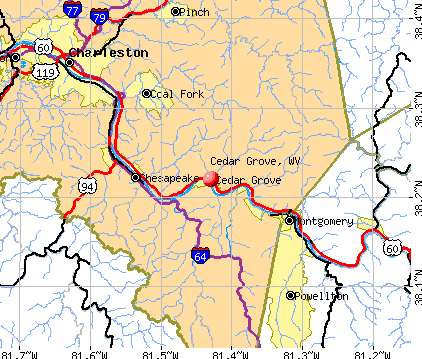
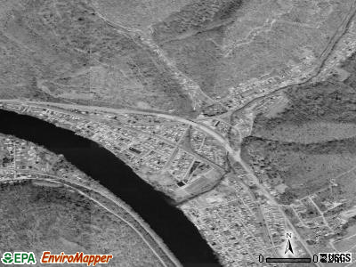
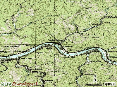
Cedar Grove, West Virginia
Submit your own pictures of this town and show them to the world
- OSM Map
- General Map
- Google Map
- MSN Map
Population change since 2000: -19.6%
| Males: 382 | |
| Females: 311 |
| Median resident age: | 44.4 years |
| West Virginia median age: | 42.9 years |
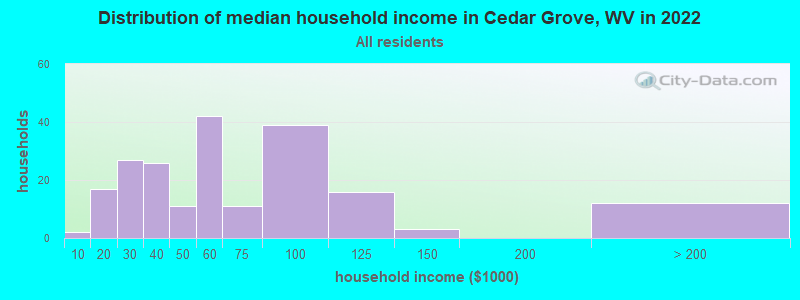
| Cedar Grove: | $55,589 |
| WV: | $54,329 |
Estimated per capita income in 2022: $27,692 (it was $12,911 in 2000)
Cedar Grove town income, earnings, and wages data
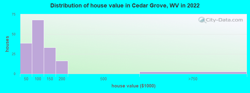
Estimated median house or condo value in 2022: $65,065 (it was $48,300 in 2000)
| Cedar Grove: | $65,065 |
| WV: | $155,100 |
Mean prices in 2022: all housing units: $91,200; detached houses: $102,149; mobile homes: $56,143
Median gross rent in 2022: $827.
(13.2% for White Non-Hispanic residents, 100.0% for two or more races residents)
Detailed information about poverty and poor residents in Cedar Grove, WV
Compare current foreclosures near Cedar Grove, WV:
| Photo | Address | Area | Beds / Baths | Price | Details |
|---|---|---|---|---|---|

|
#1
Echo Rd
Charleston, WV 25303
|
1,770 sq. feet
|
2 baths 3 beds |
$239,900
|
show details |

|
#2
Cabin Creek Rd
Eskdale, WV 25075
|
1,034 sq. feet
|
2 baths 3 beds |
$75,000
|
show details |

|
#3
Frame St
Charleston, WV 25302
|
1,150 sq. feet
|
1 baths 2 beds |
$24,900
|
show details |

|
#4
Armstrong Creed Rd
Powellton, WV 25161
|
1,281 sq. feet
|
1 baths 3 beds |
show details | |

|
#5
Midland Trl
Boomer, WV 25031
|
749 sq. feet
|
1 baths 2 beds |
show details | |

|
#6
Springfield Dr
Charleston, WV 25306
|
1,116 sq. feet
|
1 baths 3 beds |
show details | |

|
#7
Summit Dr
Charleston, WV 25302
|
- sq. feet
|
- baths - beds |
$24,900
|
show details |

|
#8
Virginia St E
Charleston, WV 25311
|
- sq. feet
|
2 baths 5 beds |
show details | |

|
#9
Hillcrest Dr
Montgomery, WV 25136
|
- sq. feet
|
- baths - beds |
$11,900
|
show details |

|
#10
Capitol St # 1000
Charleston, WV 25301
|
- sq. feet
|
- baths - beds |
show details |
| Photo | Address | Area | Beds / Baths | Price | Details |
|---|---|---|---|---|---|

|
#11
Oakwood Ln
Elkview, WV 25071
|
- sq. feet
|
- baths - beds |
show details | |

|
#12
Roselane Dr # C
Charleston, WV 25302
|
- sq. feet
|
- baths - beds |
show details | |

|
#13
Ravinia Rd
Charleston, WV 25314
|
- sq. feet
|
- baths - beds |
show details | |

|
#14
Colony Dr
Charleston, WV 25314
|
- sq. feet
|
- baths - beds |
show details | |

|
#15
Armstrong Creek Rd
Powellton, WV 25161
|
- sq. feet
|
- baths - beds |
show details | |

|
#16
Venable Ave
Charleston, WV 25304
|
- sq. feet
|
- baths - beds |
show details | |

|
#17
136th St
Charleston, WV 25315
|
- sq. feet
|
- baths - beds |
show details | |

|
#18
Wise Dr
Charleston, WV 25306
|
- sq. feet
|
- baths - beds |
show details | |

|
#19
Greenwood Ave
Charleston, WV 25302
|
- sq. feet
|
- baths - beds |
show details | |

|
#20
Campbells Creek Dr
Charleston, WV 25306
|
- sq. feet
|
- baths - beds |
show details |
| Photo | Address | Area | Beds / Baths | Price | Details |
|---|---|---|---|---|---|

|
#21
W 5th Ave
Belle, WV 25015
|
- sq. feet
|
- baths - beds |
show details | |

|
#22
Campbells Creek Dr
Blount, WV 25025
|
- sq. feet
|
- baths - beds |
show details | |

|
#23
W Gardner Ave
Belle, WV 25015
|
- sq. feet
|
- baths - beds |
show details | |

|
#24
E 8th St
Belle, WV 25015
|
- sq. feet
|
- baths - beds |
show details | |

|
#25
Ginger Dr
Peytona, WV 25154
|
- sq. feet
|
- baths - beds |
show details | |

|
#26
Grant St
Charleston, WV 25302
|
- sq. feet
|
- baths - beds |
show details | |

|
#27
Fort Hill Dr
Charleston, WV 25314
|
- sq. feet
|
- baths - beds |
show details | |

|
#28
Saint Charles Pl
Charleston, WV 25314
|
- sq. feet
|
- baths - beds |
show details | |

|
#29
Ashby Ave
Charleston, WV 25314
|
- sq. feet
|
- baths - beds |
show details | |

|
#30
Vogel Dr
Charleston, WV 25302
|
- sq. feet
|
- baths - beds |
show details |
| Photo | Address | Area | Beds / Baths | Price | Details |
|---|---|---|---|---|---|

|
#31
Skyline Dr
Charleston, WV 25302
|
- sq. feet
|
- baths - beds |
show details | |

|
#32
Park Dr
Elkview, WV 25071
|
- sq. feet
|
- baths - beds |
show details | |

|
#33
E Dundon St
Hansford, WV 25103
|
- sq. feet
|
- baths - beds |
show details | |

|
#34
Ehman Dr
Charleston, WV 25302
|
- sq. feet
|
- baths - beds |
show details | |

|
#35
Evergreen Dr
Charleston, WV 25302
|
- sq. feet
|
- baths - beds |
show details | |

|
#36
Westmoreland Dr
Charleston, WV 25302
|
- sq. feet
|
- baths - beds |
show details | |

|
#37
Odell Ave
Charleston, WV 25302
|
- sq. feet
|
- baths - beds |
show details | |

|
#38
Azalea Dr
Elkview, WV 25071
|
- sq. feet
|
- baths - beds |
show details | |

|
#39
Brittany Woods
Charleston, WV 25314
|
- sq. feet
|
- baths - beds |
show details | |

|
#40
Toneys Branch Rd
Bloomingrose, WV 25024
|
- sq. feet
|
- baths - beds |
show details |
| Photo | Address | Area | Beds / Baths | Price | Details |
|---|---|---|---|---|---|

|
#41
Elaine Dr
Charleston, WV 25306
|
- sq. feet
|
- baths - beds |
show details | |

|
#42
Maryland Ave
Charleston, WV 25315
|
- sq. feet
|
- baths - beds |
show details | |

|
#43
E 6th St
Belle, WV 25015
|
- sq. feet
|
- baths - beds |
show details | |

|
#44
E 4th St
Belle, WV 25015
|
- sq. feet
|
- baths - beds |
show details | |

|
#45
Maccorkle Ave
Charleston, WV 25315
|
- sq. feet
|
- baths - beds |
show details | |

|
#46
3rd Ave W
Montgomery, WV 25136
|
- sq. feet
|
- baths - beds |
show details | |

|
#47
Rosemont Ave
Charleston, WV 25303
|
- sq. feet
|
- baths - beds |
show details | |

|
Check over 1 million property listings on Foreclosure.com!
|
browse all offers | |||


- 48696.4%White alone
- 91.8%Two or more races

Races in Cedar Grove detailed stats: ancestries, foreign born residents, place of birth
According to our research of West Virginia and other state lists, there were 3 registered sex offenders living in Cedar Grove, West Virginia as of April 23, 2024.
The ratio of all residents to sex offenders in Cedar Grove is 267 to 1.
Full-time law enforcement employees in 2021, including police officers: 1 (1 officers - 1 male; 0 female).
| Officers per 1,000 residents here: | 1.13 |
| West Virginia average: | 1.95 |
 Recent articles from our blog. Our writers, many of them Ph.D. graduates or candidates, create easy-to-read articles on a wide variety of topics.


 | Can Charleston become the next Asheville? (47 replies) |
| Let's be the Mayor. (19 replies) |
| Starting Over in Charleston - pretty specific on what I prefer!! (50 replies) |
| Restaurants and Stores in Charleston are going up!!! (962 replies) |
| Census Burea Plans to Combine Charleston and Huntington Urbanized Areas (55 replies) |
| Manchin Vetoes Charleston's "Metro" Scheme on Technicality (36 replies) |
Latest news from Cedar Grove, WV collected exclusively by city-data.com from local newspapers, TV, and radio stations
Ancestries: English (31.9%), Irish (24.0%), American (10.5%), German (10.0%), Russian (7.4%), European (2.2%).
Current Local Time: EST time zone
Incorporated in 1902
Land area: 0.75 square miles.
Population density: 920 people per square mile (low).

3 residents are foreign born
| This town: | 0.6% |
| West Virginia: | 1.6% |
| Cedar Grove town: | 0.6% ($309) |
| West Virginia: | 0.6% ($378) |
Nearest city with pop. 50,000+: Charleston, WV  (14.2 miles , pop. 53,421).
Nearest city with pop. 200,000+: Columbus, OH (148.4 miles , pop. 711,470).
Nearest city with pop. 1,000,000+: Philadelphia, PA (358.9 miles , pop. 1,517,550).
Nearest cities:
), ), ), ), Latitude: 38.22 N, Longitude: 81.43 W
Area code commonly used in this area: 304
Property values in Cedar Grove, WV
Single-family new house construction building permits:
- 2004: 1 building, cost: $30,000
- 1999: 2 buildings, average cost: $100,000


| Here: | 3.7% |
| West Virginia: | 4.0% |

- Construction (8.7%)
- Public administration (8.1%)
- Mining, quarrying, oil & gas extraction (7.4%)
- Health care (7.4%)
- Educational services (6.8%)
- Finance & insurance (6.1%)
- Truck transportation (5.2%)

- Construction (15.3%)
- Mining, quarrying, oil & gas extraction (13.0%)
- Truck transportation (9.0%)
- Motor vehicle & parts dealers (5.6%)
- Accommodation & food services (5.6%)
- Public administration (5.1%)
- Repair & maintenance (5.1%)

- Health care (14.3%)
- Educational services (13.5%)
- Public administration (12.0%)
- Finance & insurance (9.8%)
- Personal & laundry services (6.8%)
- Administrative & support & waste management services (6.0%)
- Other direct selling establishments (3.8%)

- Other office and administrative support workers, including supervisors (8.7%)
- Vehicle and mobile equipment mechanics, installers, and repairers (6.8%)
- Driver/sales workers and truck drivers (5.5%)
- Retail sales workers, except cashiers (4.2%)
- Cashiers (3.9%)
- Laborers and material movers, hand (3.5%)
- Other production occupations, including supervisors (3.5%)

- Vehicle and mobile equipment mechanics, installers, and repairers (11.9%)
- Driver/sales workers and truck drivers (9.6%)
- Other production occupations, including supervisors (6.2%)
- Laborers and material movers, hand (6.2%)
- Building and grounds cleaning and maintenance occupations (5.1%)
- Construction traders workers except carpenters, electricians, painters, plumbers, and construction laborers (5.1%)
- Other office and administrative support workers, including supervisors (4.5%)

- Other office and administrative support workers, including supervisors (14.3%)
- Cooks and food preparation workers (6.0%)
- Cashiers (6.0%)
- Bookkeeping, accounting, and auditing clerks (6.0%)
- Secretaries and administrative assistants (6.0%)
- Retail sales workers, except cashiers (5.3%)
- Other teachers, instructors, education, training, and library occupations (4.5%)
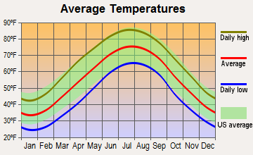
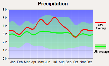
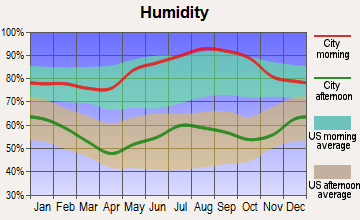
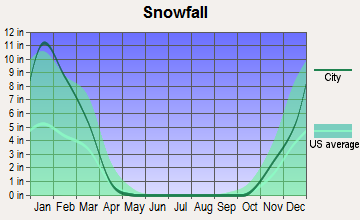
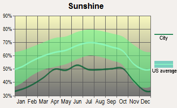
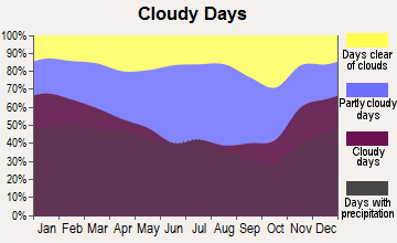
Average climate in Cedar Grove, West Virginia
Based on data reported by over 4,000 weather stations

(lower is better)

Air Quality Index (AQI) level in 2022 was 54.5. This is better than average.
| City: | 54.5 |
| U.S.: | 72.6 |

Carbon Monoxide (CO) [ppm] level in 2022 was 0.193. This is better than average. Closest monitor was 13.4 miles away from the city center.
| City: | 0.193 |
| U.S.: | 0.251 |

Sulfur Dioxide (SO2) [ppb] level in 2022 was 0.596. This is significantly better than average. Closest monitor was 12.6 miles away from the city center.
| City: | 0.596 |
| U.S.: | 1.515 |

Ozone [ppb] level in 2022 was 21.7. This is significantly better than average. Closest monitor was 13.4 miles away from the city center.
| City: | 21.7 |
| U.S.: | 33.3 |

Particulate Matter (PM10) [µg/m3] level in 2015 was 11.1. This is significantly better than average. Closest monitor was 6.2 miles away from the city center.
| City: | 11.1 |
| U.S.: | 19.2 |

Particulate Matter (PM2.5) [µg/m3] level in 2022 was 7.21. This is about average. Closest monitor was 13.6 miles away from the city center.
| City: | 7.21 |
| U.S.: | 8.11 |

Lead (Pb) [µg/m3] level in 2022 was 0.00387. This is significantly better than average. Closest monitor was 7.7 miles away from the city center.
| City: | 0.00387 |
| U.S.: | 0.00931 |
Tornado activity:
Cedar Grove-area historical tornado activity is below West Virginia state average. It is 79% smaller than the overall U.S. average.
On 4/23/1968, a category F5 (max. wind speeds 261-318 mph) tornado 58.8 miles away from the Cedar Grove town center killed 7 people and injured 93 people and caused between $500,000 and $5,000,000 in damages.
On 4/4/1974, a category F3 (max. wind speeds 158-206 mph) tornado 36.6 miles away from the town center killed one person and injured 11 people and caused between $500,000 and $5,000,000 in damages.
Earthquake activity:
Cedar Grove-area historical earthquake activity is significantly above West Virginia state average. It is 10% smaller than the overall U.S. average.On 8/23/2011 at 17:51:04, a magnitude 5.8 (5.8 MW, Depth: 3.7 mi, Class: Moderate, Intensity: VI - VII) earthquake occurred 191.4 miles away from the city center
On 7/27/1980 at 18:52:21, a magnitude 5.2 (5.1 MB, 4.7 MS, 5.0 UK, 5.2 UK) earthquake occurred 136.6 miles away from Cedar Grove center
On 8/9/2020 at 12:07:37, a magnitude 5.1 (5.1 MW, Depth: 4.7 mi) earthquake occurred 122.1 miles away from the city center
On 9/25/1998 at 19:52:52, a magnitude 5.2 (4.8 MB, 4.3 MS, 5.2 LG, 4.5 MW, Depth: 3.1 mi) earthquake occurred 232.8 miles away from Cedar Grove center
On 9/7/1988 at 02:28:09, a magnitude 4.6 (4.5 MB, 4.6 LG, Class: Light, Intensity: IV - V) earthquake occurred 133.2 miles away from Cedar Grove center
On 11/2/2006 at 17:53:02, a magnitude 4.3 (4.3 MB, Depth: 0.6 mi) earthquake occurred 75.5 miles away from the city center
Magnitude types: regional Lg-wave magnitude (LG), body-wave magnitude (MB), surface-wave magnitude (MS), moment magnitude (MW)
Natural disasters:
The number of natural disasters in Kanawha County (28) is a lot greater than the US average (15).Major Disasters (Presidential) Declared: 22
Emergencies Declared: 5
Causes of natural disasters: Floods: 15, Storms: 14, Landslides: 8, Winter Storms: 5, Hurricanes: 3, Mudslides: 3, Blizzard: 1, Fire: 1, Heavy Rain: 1, Snowfall: 1, Snowstorm: 1, Tornado: 1, Wind: 1, Other: 2 (Note: some incidents may be assigned to more than one category).
Hospitals and medical centers near Cedar Grove:
- MONTGOMERY GEN. ELDERLY CARE (Nursing Home, about 7 miles away; MONTGOMERY, WV)
- HIGHLAND HOSPITAL (Hospital, about 11 miles away; CHARLESTON, WV)
- HEARTLAND OF CHARLESTON (Nursing Home, about 12 miles away; CHARLESTON, WV)
- FMS - CHARLESTON (Dialysis Facility, about 13 miles away; CHARLESTON, WV)
- AMEDISYS HOME HEALTH OF WEST VIRGINIA (Home Health Center, about 13 miles away; CHARLESTON, WV)
- MEADOWBROOK ACRES (Nursing Home, about 14 miles away; CHARLESTON, WV)
- OAK RIDGE CENTER (Nursing Home, about 14 miles away; CHARLESTON, WV)
Amtrak stations near Cedar Grove:
- 7 miles: MONTGOMERY (WASHINGTON ST. & 3RD AVE.) . Services: public payphones, free short-term parking, free long-term parking, call for taxi service, public transit connection.
- 15 miles: CHARLESTON (350 MCCORKLE AVE. SE) . Services: ticket office, fully wheelchair accessible, enclosed waiting area, public restrooms, public payphones, vending machines, free short-term parking, free long-term parking, call for taxi service, public transit connection.
Colleges/universities with over 2000 students nearest to Cedar Grove:
- West Virginia State University (about 22 miles; Institute, WV; Full-time enrollment: 2,133)
- New River Community and Technical College (about 32 miles; Beckley, WV; FT enrollment: 2,234)
- Marshall University (about 57 miles; Huntington, WV; FT enrollment: 11,450)
- Concord University (about 60 miles; Athens, WV; FT enrollment: 2,698)
- Ashland Community and Technical College (about 69 miles; Ashland, KY; FT enrollment: 2,482)
- West Virginia University at Parkersburg (about 70 miles; Parkersburg, WV; FT enrollment: 2,619)
- Big Sandy Community and Technical College (about 83 miles; Prestonsburg, KY; FT enrollment: 2,660)
Points of interest:
Notable locations in Cedar Grove: Kanawha County Emergency Ambulance Authority Station 68 (A), Cedar Grove Volunteer Fire Department (B). Display/hide their locations on the map
Church in Cedar Grove: Little Brick Church (A). Display/hide its location on the map
Cemeteries: Virginias Chapel Slave Cemetery (1), Woodland Cemetery (2). Display/hide their locations on the map
Streams, rivers, and creeks: Mile Branch (A), Kellys Creek (B), Horsemill Branch (C), Frozen Branch (D). Display/hide their locations on the map
Drinking water stations with addresses in Cedar Grove and their reported violations in the past:
CEDAR GROVE, COMMUNITY OF (Population served: 1,090, Surface water):Past health violations:Past monitoring violations:
- MCL, Average - Between APR-2012 and JUN-2012, Contaminant: Total Haloacetic Acids (HAA5). Follow-up actions: St Public Notif requested (AUG-01-2012), St Formal NOV issued (AUG-01-2012), St Public Notif received (AUG-09-2012), St Compliance achieved (MAR-21-2013)
- MCL, Average - Between JAN-2012 and MAR-2012, Contaminant: Total Haloacetic Acids (HAA5). Follow-up actions: St Public Notif requested (MAY-14-2012), St Formal NOV issued (MAY-14-2012), St Compliance achieved (MAR-21-2013)
- MCL, Average - Between OCT-2011 and DEC-2011, Contaminant: Total Haloacetic Acids (HAA5). Follow-up actions: St Formal NOV issued (JAN-21-2012), St Public Notif requested (JAN-21-2012), St Public Notif received (FEB-17-2012), Fed Formal NOV issued (NOV-16-2012), St Compliance achieved (MAR-21-2013), Fed Compliance achieved (AUG-01-2013)
- MCL, Average - Between JUL-2011 and SEP-2011, Contaminant: Total Haloacetic Acids (HAA5). Follow-up actions: St Formal NOV issued (NOV-02-2011), St Public Notif requested (NOV-02-2011), St Public Notif received (DEC-09-2011), Fed Formal NOV issued (NOV-16-2012), St Compliance achieved (MAR-21-2013), Fed Compliance achieved (AUG-01-2013)
- MCL, Average - Between APR-2011 and JUN-2011, Contaminant: Total Haloacetic Acids (HAA5). Follow-up actions: St Formal NOV issued (AUG-03-2011), St Public Notif requested (AUG-03-2011), St Public Notif received (JUN-14-2012), Fed Formal NOV issued (NOV-16-2012), St Compliance achieved (MAR-21-2013), Fed Compliance achieved (AUG-01-2013)
- MCL, Average - Between OCT-2010 and DEC-2010, Contaminant: Total Haloacetic Acids (HAA5). Follow-up actions: St Formal NOV issued (FEB-03-2011), St Public Notif requested (FEB-03-2011), St Public Notif received (MAR-28-2011), Fed Formal NOV issued (NOV-16-2012), St Compliance achieved (MAR-21-2013), Fed Compliance achieved (AUG-01-2013)
- 4 other older health violations
- Single Turbidity Exceed (Enhanced SWTR) - In APR-2012, Contaminant: IESWTR. Follow-up actions: St Compliance achieved (MAY-31-2012), St Public Notif requested (JUN-08-2012), St Formal NOV issued (JUN-08-2012), St Public Notif received (AUG-09-2012)
- One minor monitoring violation
| This town: | 2.5 people |
| West Virginia: | 2.4 people |
| This town: | 69.8% |
| Whole state: | 65.8% |
| This town: | 6.5% |
| Whole state: | 6.6% |
No gay or lesbian households reported
2 people in workers' group living quarters and job corps centers in 2010
6 people in other noninstitutional group quarters in 2000
For population 15 years and over in Cedar Grove:

- Never married: 28.7%
- Now married: 48.9%
- Separated: 2.3%
- Widowed: 9.2%
- Divorced: 10.9%
For population 25 years and over in Cedar Grove:
- High school or higher: 81.9%
- Bachelor's degree or higher: 4.5%
- Graduate or professional degree: 3.1%
- Unemployed: 10.1%
- Mean travel time to work (commute): 36.0 minutes


| Here: | 8.9 |
| West Virginia average: | 11.1 |
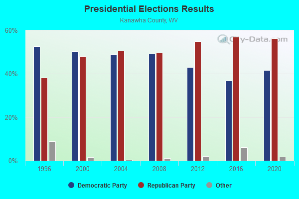
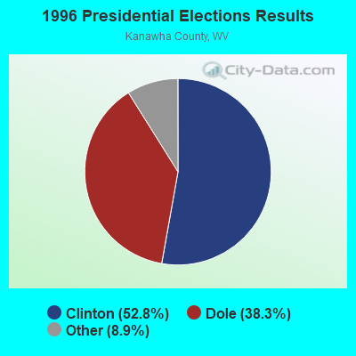
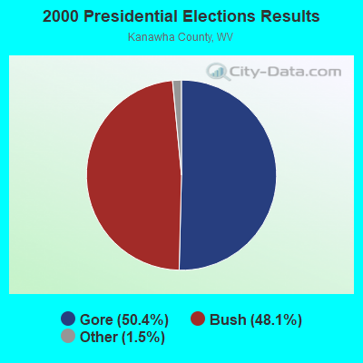
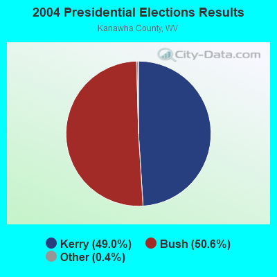
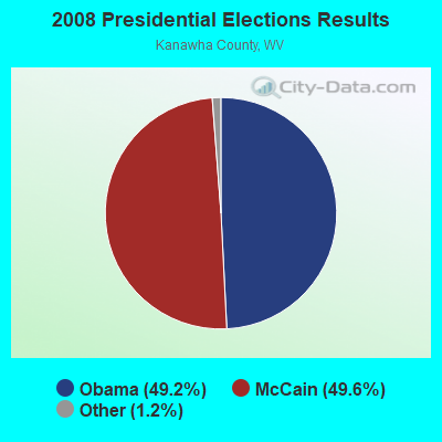
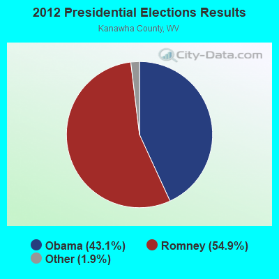
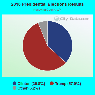
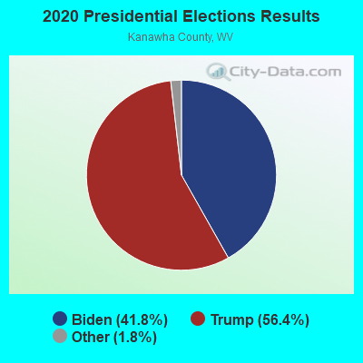
Graphs represent county-level data. Detailed 2008 Election Results
Religion statistics for Cedar Grove, WV (based on Kanawha County data)
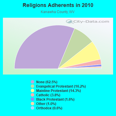
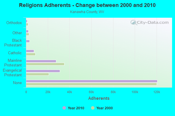
| Religion | Adherents | Congregations |
|---|---|---|
| Evangelical Protestant | 31,202 | 219 |
| Mainline Protestant | 27,583 | 114 |
| Catholic | 7,331 | 11 |
| Black Protestant | 3,114 | 12 |
| Other | 2,020 | 10 |
| Orthodox | 1,136 | 2 |
| None | 120,677 | - |
Food Environment Statistics:
| This county: | 2.46 / 10,000 pop. |
| West Virginia: | 2.41 / 10,000 pop. |
| Kanawha County: | 0.16 / 10,000 pop. |
| West Virginia: | 0.28 / 10,000 pop. |
| Kanawha County: | 0.52 / 10,000 pop. |
| West Virginia: | 1.09 / 10,000 pop. |
| This county: | 5.13 / 10,000 pop. |
| West Virginia: | 5.38 / 10,000 pop. |
| This county: | 6.90 / 10,000 pop. |
| State: | 6.22 / 10,000 pop. |
| Kanawha County: | 12.1% |
| West Virginia: | 12.2% |
| This county: | 29.6% |
| West Virginia: | 31.1% |
| This county: | 12.0% |
| West Virginia: | 13.1% |
Health and Nutrition:
| Here: | 63.3% |
| State: | 51.8% |
| Cedar Grove: | 67.2% |
| State: | 49.7% |
| Cedar Grove: | 26.8 |
| West Virginia: | 28.6 |
| This city: | 17.9% |
| West Virginia: | 20.4% |
| Here: | 9.1% |
| State: | 9.7% |
| Here: | 7.4 |
| West Virginia: | 6.9 |
| Cedar Grove: | 35.2% |
| West Virginia: | 34.8% |
| This city: | 68.6% |
| West Virginia: | 58.4% |
| Cedar Grove: | 84.2% |
| West Virginia: | 78.6% |
More about Health and Nutrition of Cedar Grove, WV Residents
| Local government employment and payroll (March 2022) | |||||
| Function | Full-time employees | Monthly full-time payroll | Average yearly full-time wage | Part-time employees | Monthly part-time payroll |
|---|---|---|---|---|---|
| Water Supply | 2 | $7,312 | $43,872 | 1 | $1,950 |
| Streets and Highways | 2 | $3,236 | $19,416 | 0 | $0 |
| Financial Administration | 0 | $0 | 1 | $367 | |
| Other Government Administration | 0 | $0 | 8 | $1,096 | |
| Police Protection - Officers | 0 | $0 | 1 | $4,411 | |
| Sewerage | 0 | $0 | 2 | $2,363 | |
| Solid Waste Management | 0 | $0 | 1 | $1,618 | |
| Totals for Government | 4 | $10,548 | $31,644 | 14 | $11,805 |
Cedar Grove government finances - Expenditure in 2017 (per resident):
- Current Operations - Water Utilities: $311,000 ($448.77)
Sewerage: $162,000 ($233.77)
Police Protection: $95,000 ($137.09)
Solid Waste Management: $67,000 ($96.68)
Central Staff Services: $6,000 ($8.66)
Financial Administration: $3,000 ($4.33)
Judicial and Legal Services: $3,000 ($4.33)
- Total Salaries and Wages: $236,000 ($340.55)
Cedar Grove government finances - Revenue in 2017 (per resident):
- Charges - Sewerage: $266,000 ($383.84)
Solid Waste Management: $67,000 ($96.68)
- Miscellaneous - Fines and Forfeits: $8,000 ($11.54)
- Revenue - Water Utilities: $342,000 ($493.51)
- Tax - Property: $73,000 ($105.34)
Alcoholic Beverage Sales: $2,000 ($2.89)
Businesses in Cedar Grove, WV
- Advance Auto Parts: 1
- Kincaid: 1
Strongest AM radio stations in Cedar Grove:
- WCAW (680 AM; 10 kW; CHARLESTON, WV; Owner: WEST VIRGINIA RADIO CORPORATION OF CHARLESTON)
- WOAY (860 AM; 10 kW; OAK HILL, WV; Owner: COMMISSIONED COMMUNICATIONS, INC.)
- WCHS (580 AM; 5 kW; CHARLESTON, WV; Owner: WEST VIRGINIA RADIO CORPORATION OF CHARLESTON)
- WMON (1340 AM; 1 kW; MONTGOMERY, WV; Owner: L.M. COMMUNICATIONS OF KENTUCKY, LLC)
- WVTS (950 AM; 5 kW; CHARLESTON, WV; Owner: BRISTOL BROADCASTING COMPANY, INC.)
- WSCW (1410 AM; daytime; 5 kW; SOUTH CHARLESTON, WV; Owner: L.M. COMMUNICATIONS OF KENTUCKY, LLC)
- WIWS (1070 AM; daytime; 10 kW; BECKLEY, WV; Owner: SOUTHERN COMMUNICATIONS CORPORATION)
- WJLS (560 AM; 5 kW; BECKLEY, WV; Owner: FIRST MEDIA RADIO, LLC)
- WWNR (620 AM; 5 kW; BECKLEY, WV; Owner: DYNASTAR COMMUNICATIONS, INC.)
- WTVN (610 AM; 50 kW; COLUMBUS, OH; Owner: CITICASTERS LICENSES, L.P.)
- WSWW (1490 AM; 1 kW; CHARLESTON, WV; Owner: WEST VIRGINIA RADIO CORPORATION OF CHARLESTON)
- WBGS (1030 AM; daytime; 10 kW; POINT PLEASANT, WV; Owner: BIG RIVER RADIO, INC.)
- WVOW (1290 AM; 5 kW; LOGAN, WV; Owner: LOGAN BROADCASTING CORPORATION)
Strongest FM radio stations in Cedar Grove:
- WKVW (93.3 FM; MONTGOMERY, WV; Owner: EDUCATIONAL MEDIA FOUNDATION)
- WKAZ (107.3 FM; MIAMI, WV; Owner: WEST VIRGINIA RADIO CORPORATION OF CHARLESTON)
- WXAF (90.9 FM; CHARLESTON, WV; Owner: MARANATHA BROADCASTING, INC.)
- WCIR-FM (103.7 FM; BECKLEY, WV; Owner: SOUTHERN COMMUNICATIONS CORPORATION)
- WKLC-FM (105.1 FM; ST. ALBANS, WV; Owner: WKLC, INC.)
- WKWS (96.1 FM; CHARLESTON, WV; Owner: WEST VIRGINIA RADIO CORPORATION OF CHARLESTON)
- WVAF (99.9 FM; CHARLESTON, WV; Owner: WEST VIRGINIA RADIO CORPORATION OF CHARLESTON)
- WVPN (88.5 FM; CHARLESTON, WV; Owner: WEST VIRGINIA EDUCATIONAL BROADCASTING AUTHORITY)
- WDBS (97.1 FM; SUTTON, WV; Owner: SUMMIT MEDIA BROADCASTING, L.L.C.)
- WRVZ (98.7 FM; POCATALICO, WV; Owner: WEST VIRGINIA RADIO CORPORATION OF CHARLESTON)
- WZAC-FM (92.5 FM; DANVILLE, WV; Owner: PRICE BROADCASTING COMPANY)
- WVSR-FM (102.7 FM; CHARLESTON, WV; Owner: BRISTOL BROADCASTING COMPANY, INC.)
- WAXS (94.1 FM; OAK HILL, WV; Owner: PLATEAU BROADCASTING, INC.)
- WZJO (94.5 FM; DUNBAR, WV; Owner: BRISTOL BROADCASTING COMPANY, INC)
- WQBE-FM (97.5 FM; CHARLESTON, WV; Owner: BRISTOL BROADCASTING COMPANY)
- WVPB (91.7 FM; BECKLEY, WV; Owner: WEST VIRGINIA EDUCATIONAL BROADCASTING AUTHORITY)
- WMTD-FM (102.3 FM; HINTON, WV; Owner: SOUTHERN COMMUNICATIONS CORPORATION)
- WVWV (89.9 FM; HUNTINGTON, WV; Owner: WEST VIRGINIA EDUCATIONAL BROADCASTING AUTHORITY)
- WAMX (106.3 FM; MILTON, WV; Owner: CAPSTAR TX LIMITED PARTNERSHIP)
- W208AK (89.5 FM; CHARLESTON, WV; Owner: LOWER OHIO VALLEY EDUCATIONAL CORP.)
TV broadcast stations around Cedar Grove:
- WVAH-TV (Channel 11; CHARLESTON, WV; Owner: WVAH LICENSEE, LLC)
- WCHS-TV (Channel 8; CHARLESTON, WV; Owner: WCHS LICENSEE, LLC)
- WLPX-TV (Channel 29; CHARLESTON, WV; Owner: PAXSON CHARLESTON LICENSE, INC.)
- WOAY-TV (Channel 4; OAK HILL, WV; Owner: THOMAS BROADCASTING CO.)
- WPBY-TV (Channel 33; HUNTINGTON, WV; Owner: WEST VIRGINIA EDUCATIONAL BROADCASTING AUTHORITY)
- WOWK-TV (Channel 13; HUNTINGTON, WV; Owner: WEST VIRGINIA MEDIA HOLDINGS, LLC)
- W16CE (Channel 16; CHARLESTON, WV; Owner: EMMIS TELEVISION LICENSE CORPORATION)
- Cedar Grove, West Virginia
- Fatal accident count8
- Vehicles involved in fatal accidents14
- Fatal accidents involving drunk persons:1
- Fatalities8
- Persons involved in fatal accidents22
- Pedestrians involved in fatal accidents0
- West Virginia average
- Fatal accident count2959
- Vehicles involved in fatal accidents4296
- Fatal accidents involving drunk persons962
- Fatalities3324
- Persons involved in fatal accidents7336
- Pedestrians involved in fatal accidents109
- National Bridge Inventory (NBI) Statistics
- 5Number of bridges
- 43ft / 12.8mTotal length
- $550,000Total costs
- 11,020Total average daily traffic
- 550Total average daily truck traffic
- 11,916Total future (year 2038) average daily traffic
FCC Registered Cell Phone Towers:
1 (See the full list of FCC Registered Cell Phone Towers in Cedar Grove)FCC Registered Antenna Towers:
18 (See the full list of FCC Registered Antenna Towers)FCC Registered Broadcast Land Mobile Towers:
1- Int Of Cr 81 & Sr 81 (Lat: 38.239000 Lon: -81.434000), Call Sign: WYG240,
Assigned Frequencies: 155.145 MHz, 155.745 MHz, Grant Date: 09/12/2023, Expiration Date: 11/14/2033, Registrant: Metro 911 Kanawha County Emergency Operations Center, 200 Peyton Way, Charleston, WV 25309-8627, Phone: (304) 746-7911, Fax: (304) 746-7914, Email:
FCC Registered Microwave Towers:
1- CEDAR GROVE, Big Mountain Road Route 61 Po Box 369 (Lat: 38.220750 Lon: -81.414333), Type: Ltower, Structure height: 69.2 m, Overall height: 100.6 m, Call Sign: WMV924,
Assigned Frequencies: 10835.0 MHz, 5974.85 MHz, 6034.15 MHz, 5945.20 MHz, 6004.50 MHz, 5974.85 MHz, 6034.15 MHz, 6063.80 MHz, 6093.45 MHz, 6093.45 MHz, Grant Date: 01/12/2021, Expiration Date: 02/01/2031, Certifier: Carol L Tacker, Registrant: At&t Services, Inc., 208 S Akard St, 20f, Dallas, TX 75202, Phone: (855) 699-7073, Email:
FCC Registered Amateur Radio Licenses:
3- Call Sign: KB8OMZ, Licensee ID: L00877387, Grant Date: 06/17/2004, Expiration Date: 06/17/2014, Cancellation Date: 06/18/2016, Registrant: Richard H Buckley, Hc 66 409 Rubes Hollow, Cedar Grove, WV 25039
- Call Sign: KB8WKT, Grant Date: 01/18/1995, Expiration Date: 01/18/2005, Cancellation Date: 01/19/2007, Registrant: David A Coffey, Cedar Grove, WV 25039
- Call Sign: KB8YZS, Grant Date: 04/20/1995, Expiration Date: 04/20/2005, Cancellation Date: 04/21/2007, Registrant: Chistopher S Wood, Cedar Grove, WV 25039
2003 - 2018 National Fire Incident Reporting System (NFIRS) incidents
- Fire incident types reported to NFIRS in Cedar Grove, WV
- 10355.4%Structure Fires
- 5228.0%Outside Fires
- 179.1%Other
- 147.5%Mobile Property/Vehicle Fires
 Based on the data from the years 2003 - 2018 the average number of fire incidents per year is 12. The highest number of fire incidents - 32 took place in 2007, and the least - 0 in 2004. The data has a rising trend.
 When looking into fire subcategories, the most incidents belonged to: Structure Fires (55.4%), and Outside Fires (28.0%).
| Most common first names in Cedar Grove, WV among deceased individuals | ||
| Name | Count | Lived (average) |
|---|---|---|
| William | 22 | 70.1 years |
| James | 20 | 69.2 years |
| Charles | 19 | 65.2 years |
| John | 14 | 77.0 years |
| Robert | 14 | 70.4 years |
| George | 12 | 73.2 years |
| Henry | 9 | 74.7 years |
| Mary | 8 | 73.5 years |
| Anna | 8 | 74.4 years |
| Harry | 8 | 68.5 years |
| Most common last names in Cedar Grove, WV among deceased individuals | ||
| Last name | Count | Lived (average) |
|---|---|---|
| Hudnall | 25 | 73.2 years |
| Martin | 12 | 77.3 years |
| Mullins | 11 | 71.2 years |
| Johnson | 11 | 75.8 years |
| Young | 9 | 78.4 years |
| Smith | 8 | 69.7 years |
| Craigo | 8 | 64.2 years |
| Richards | 8 | 69.0 years |
| Knight | 8 | 73.8 years |
| Adkins | 7 | 70.6 years |
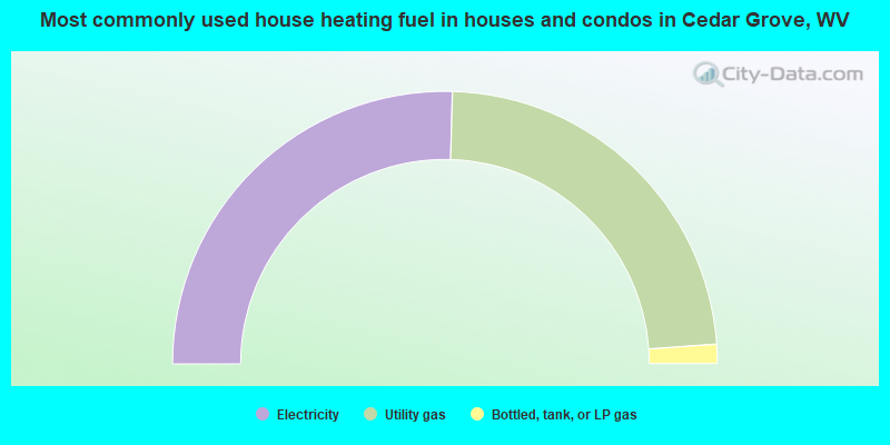
- 50.9%Electricity
- 46.8%Utility gas
- 2.3%Bottled, tank, or LP gas
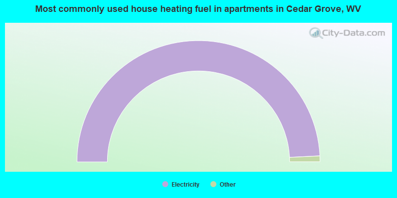
- 100.0%Electricity
Cedar Grove compared to West Virginia state average:
- Median house value significantly below state average.
- Black race population percentage significantly below state average.
- Hispanic race population percentage significantly below state average.
- Foreign-born population percentage significantly below state average.
- Length of stay since moving in significantly above state average.
- Percentage of population with a bachelor's degree or higher significantly below state average.