Chilmark, Massachusetts
Submit your own pictures of this town and show them to the world
- OSM Map
- General Map
- Google Map
- MSN Map

Population change since 2000: +2.7%
 |
| Males: 439 | |
| Females: 427 |
| Median resident age: | 50.7 years |
| Massachusetts median age: | 39.2 years |
Zip codes: 02535.
| Chilmark: | $83,980 |
| MA: | $94,488 |
Estimated per capita income in 2022: $69,681 (it was $30,029 in 2000)
Chilmark town income, earnings, and wages data
Estimated median house or condo value in 2022: over $1,000,000 (it was $732,700 in 2000)
| Chilmark: | over $1,000,000 |
| MA: | $534,700 |
Mean prices in 2022: all housing units: over $1,000,000; detached houses: over $1,000,000; townhouses or other attached units: over $1,000,000; in 2-unit structures: $912,859; in 3-to-4-unit structures: $934,263
Detailed information about poverty and poor residents in Chilmark, MA


- 83095.8%White alone
- 151.7%Black alone
- 91.0%Two or more races
- 70.8%Hispanic
- 20.2%American Indian alone
- 20.2%Asian alone
- 10.1%Other race alone

Races in Chilmark detailed stats: ancestries, foreign born residents, place of birth
Type |
2009 |
2010 |
2011 |
2012 |
2013 |
2015 |
2016 |
2017 |
2018 |
2019 |
2020 |
2021 |
2022 |
|---|---|---|---|---|---|---|---|---|---|---|---|---|---|
| Murders (per 100,000) | 0 (0.0) | 0 (0.0) | 0 (0.0) | 0 (0.0) | 0 (0.0) | 0 (0.0) | 0 (0.0) | 0 (0.0) | 0 (0.0) | 0 (0.0) | 0 (0.0) | 0 (0.0) | 0 (0.0) |
| Rapes (per 100,000) | 0 (0.0) | 0 (0.0) | 0 (0.0) | 0 (0.0) | 0 (0.0) | 0 (0.0) | 0 (0.0) | 0 (0.0) | 0 (0.0) | 0 (0.0) | 0 (0.0) | 1 (105.5) | 0 (0.0) |
| Robberies (per 100,000) | 0 (0.0) | 0 (0.0) | 0 (0.0) | 0 (0.0) | 0 (0.0) | 0 (0.0) | 0 (0.0) | 0 (0.0) | 0 (0.0) | 0 (0.0) | 0 (0.0) | 0 (0.0) | 0 (0.0) |
| Assaults (per 100,000) | 0 (0.0) | 0 (0.0) | 1 (114.8) | 0 (0.0) | 1 (109.8) | 0 (0.0) | 4 (432.0) | 2 (216.2) | 0 (0.0) | 3 (326.1) | 1 (107.9) | 2 (211.0) | 0 (0.0) |
| Burglaries (per 100,000) | 5 (507.1) | 6 (692.8) | 4 (459.2) | 2 (225.7) | 1 (109.8) | 1 (107.0) | 2 (216.0) | 1 (108.1) | 0 (0.0) | 0 (0.0) | 2 (215.7) | 0 (0.0) | 0 (0.0) |
| Thefts (per 100,000) | 10 (1,014) | 21 (2,425) | 16 (1,837) | 8 (902.9) | 7 (768.4) | 11 (1,176) | 5 (540.0) | 13 (1,405) | 9 (975.1) | 6 (652.2) | 7 (755.1) | 4 (421.9) | 2 (154.8) |
| Auto thefts (per 100,000) | 0 (0.0) | 1 (115.5) | 0 (0.0) | 0 (0.0) | 0 (0.0) | 1 (107.0) | 0 (0.0) | 0 (0.0) | 0 (0.0) | 0 (0.0) | 0 (0.0) | 0 (0.0) | 0 (0.0) |
| Arson (per 100,000) | 0 (0.0) | 0 (0.0) | 0 (0.0) | 0 (0.0) | 0 (0.0) | 1 (107.0) | 0 (0.0) | 0 (0.0) | 0 (0.0) | 0 (0.0) | 0 (0.0) | 0 (0.0) | 0 (0.0) |
| City-Data.com crime index | 76.1 | 154.7 | 128.6 | 51.9 | 60.4 | 63.1 | 123.1 | 107.0 | 39.0 | 91.3 | 66.9 | 143.5 | 6.2 |
The City-Data.com crime index weighs serious crimes and violent crimes more heavily. Higher means more crime, U.S. average is 246.1. It adjusts for the number of visitors and daily workers commuting into cities.

Crime rate in Chilmark detailed stats: murders, rapes, robberies, assaults, burglaries, thefts, arson
Full-time law enforcement employees in 2016, including police officers: 5 (5 officers - 5 male; 0 female).
| Officers per 1,000 residents here: | 5.40 |
| Massachusetts average: | 2.63 |
 Recent articles from our blog. Our writers, many of them Ph.D. graduates or candidates, create easy-to-read articles on a wide variety of topics.


 | MA is Snobby (321 replies) |
| Big MA Ancestry Data Thread by Town (31 replies) |
| Could my young family be happy in MA? (152 replies) |
| Martha’s Vinyard or Nantucket for vacation? (26 replies) |
| How Much Massachusetts Households Make Per Year: Census Data (37 replies) |
| Barnstable Town, MA Happiest Place to live in Massachusetts And in New England (13 replies) |
Latest news from Chilmark, MA collected exclusively by city-data.com from local newspapers, TV, and radio stations
Chilmark, MA City Guides:
Ancestries: English (31.2%), German (15.9%), Irish (15.4%), French (8.1%), United States (7.7%), Scottish (7.5%).
Current Local Time: EST time zone
Incorporated in 1714
Elevation: 91 feet
Land area: 19.1 square miles.
Population density: 45 people per square mile (very low).

45 residents are foreign born (3.7% Europe, 0.8% North America, 0.6% Asia).
| This town: | 5.3% |
| Massachusetts: | 12.2% |
| Chilmark town: | 0.2% ($1,152) |
| Massachusetts: | 1.3% ($2,336) |
Nearest city with pop. 50,000+: New Bedford, MA  (23.2 miles , pop. 93,768).
Nearest city with pop. 200,000+: Boston, MA (69.6 miles , pop. 589,141).
Nearest city with pop. 1,000,000+: Queens, NY (166.7 miles , pop. 2,229,379).
Nearest cities:
), Latitude: 41.35 N, Longitude: 70.74 W
Area code: 508


Single-family new house construction building permits:
- 2022: 16 buildings, average cost: $1,786,900
- 2021: 17 buildings, average cost: $124,000
- 2020: 14 buildings, average cost: $124,000
- 2019: 12 buildings, average cost: $124,000
- 2018: 12 buildings, average cost: $124,000
- 2017: 12 buildings, average cost: $124,000
- 2016: 12 buildings, average cost: $124,000
- 2015: 12 buildings, average cost: $124,000
- 2014: 12 buildings, average cost: $124,000
- 2013: 13 buildings, average cost: $124,000
- 2012: 12 buildings, average cost: $124,000
- 2011: 12 buildings, average cost: $124,000
- 2010: 17 buildings, average cost: $124,000
- 2009: 17 buildings, average cost: $124,000
- 2008: 21 buildings, average cost: $124,000
- 2007: 30 buildings, average cost: $124,000
- 2006: 39 buildings, average cost: $124,000
- 2005: 46 buildings, average cost: $124,000
- 2004: 51 buildings, average cost: $124,000
- 2003: 48 buildings, average cost: $124,000
- 2002: 44 buildings, average cost: $124,000
- 2001: 40 buildings, average cost: $124,000
- 2000: 36 buildings, average cost: $124,000
- 1999: 34 buildings, average cost: $124,000
- 1998: 33 buildings, average cost: $124,000
- 1997: 28 buildings, average cost: $124,000


| Here: | 4.4% |
| Massachusetts: | 3.5% |


- Construction (14.6%)
- Arts, entertainment, recreation (7.5%)
- Educational services (7.3%)
- Real estate & rental & leasing (7.3%)
- Agriculture, forestry, fishing & hunting (6.6%)
- Public administration (5.9%)
- Finance & insurance (5.9%)

- Construction (26.3%)
- Arts, entertainment, recreation (8.0%)
- Agriculture, forestry, fishing & hunting (7.1%)
- Administrative & support & waste management services (7.1%)
- Finance & insurance (5.4%)
- Real estate & rental & leasing (5.4%)
- Professional, scientific, technical services (5.4%)

- Educational services (12.1%)
- Real estate & rental & leasing (9.3%)
- Health care (8.9%)
- Public administration (7.0%)
- Arts, entertainment, recreation (7.0%)
- Finance & insurance (6.5%)
- Agriculture, forestry, fishing & hunting (6.1%)

- Other sales and related occupations, including supervisors (9.6%)
- Building and grounds cleaning and maintenance occupations (8.2%)
- Carpenters (6.4%)
- Other management occupations, except farmers and farm managers (5.0%)
- Other financial specialists (4.8%)
- Farmers and farm managers (3.7%)
- Supervisors, construction and extraction workers (3.7%)

- Carpenters (12.5%)
- Building and grounds cleaning and maintenance occupations (8.9%)
- Other sales and related occupations, including supervisors (7.6%)
- Supervisors, construction and extraction workers (7.1%)
- Fishing, hunting, and forestry occupations (6.2%)
- Other management occupations, except farmers and farm managers (5.8%)
- Top executives (5.4%)

- Other sales and related occupations, including supervisors (11.7%)
- Building and grounds cleaning and maintenance occupations (7.5%)
- Other financial specialists (6.5%)
- Preschool, kindergarten, elementary, and middle school teachers (6.1%)
- Farmers and farm managers (5.6%)
- Information and record clerks, except customer service representatives (4.7%)
- Supervisors and other personal care and service workers, except child care workers (4.7%)
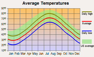
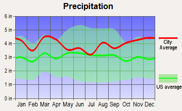
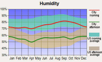
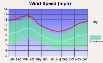
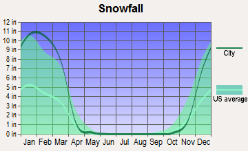
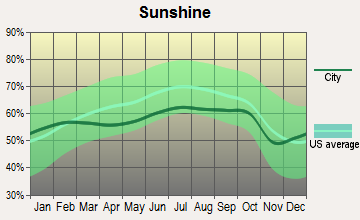
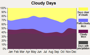
Average climate in Chilmark, Massachusetts
Based on data reported by over 4,000 weather stations
(lower is better)

Air Quality Index (AQI) level in 2022 was 51.5. This is significantly better than average.
| City: | 51.5 |
| U.S.: | 72.6 |


Ozone [ppb] level in 2022 was 35.5. This is about average. Closest monitor was 2.8 miles away from the city center.
| City: | 35.5 |
| U.S.: | 33.3 |
Earthquake activity:
Chilmark-area historical earthquake activity is significantly above Massachusetts state average. It is 77% smaller than the overall U.S. average.On 8/22/1992 at 12:20:32, a magnitude 4.8 (4.8 MB, 3.8 MS, 4.7 LG, Depth: 6.2 mi, Class: Light, Intensity: IV - V) earthquake occurred 156.8 miles away from the city center
On 10/7/1983 at 10:18:46, a magnitude 5.3 (5.1 MB, 5.3 LG, 5.1 ML, Class: Moderate, Intensity: VI - VII) earthquake occurred 256.9 miles away from the city center
On 4/20/2002 at 10:50:47, a magnitude 5.3 (5.3 ML, Depth: 3.0 mi) earthquake occurred 265.1 miles away from the city center
On 1/19/1982 at 00:14:42, a magnitude 4.7 (4.5 MB, 4.7 MD, 4.5 LG) earthquake occurred 155.1 miles away from Chilmark center
On 10/16/2012 at 23:12:25, a magnitude 4.7 (4.7 ML, Depth: 10.0 mi) earthquake occurred 155.5 miles away from the city center
On 4/20/2002 at 10:50:47, a magnitude 5.2 (5.2 MB, 4.2 MS, 5.2 MW, 5.0 MW) earthquake occurred 264.3 miles away from the city center
Magnitude types: regional Lg-wave magnitude (LG), body-wave magnitude (MB), duration magnitude (MD), local magnitude (ML), surface-wave magnitude (MS), moment magnitude (MW)
Natural disasters:
The number of natural disasters in Dukes County (19) is greater than the US average (15).Major Disasters (Presidential) Declared: 11
Emergencies Declared: 7
Causes of natural disasters: Hurricanes: 7, Floods: 4, Storms: 4, Snowstorms: 3, Blizzards: 2, Snows: 2, Winter Storms: 2, Snowfall: 1, Tropical Storm: 1, Wind: 1, Other: 1 (Note: some incidents may be assigned to more than one category).
Hospitals and medical centers near Chilmark:
- BARNSTABLE COUNTY HOSPITAL (Hospital, about 10 miles away; POCASSET, MA)
- CAPE COD AND ISLANDS MENTAL HEALTH CENTER (Hospital, about 10 miles away; POCASSET, MA)
- COLONIAL CARE CERTIFIED, INC (Home Health Center, about 16 miles away; FALMOUTH, MA)
- FALMOUTH NURSING HOME (Nursing Home, about 16 miles away; FALMOUTH, MA)
- ROYAL NURSING CENTER, LLC (Nursing Home, about 16 miles away; FALMOUTH, MA)
- VNA OF UPPER CAPE COD INC (Home Health Center, about 16 miles away; FALMOUTH, MA)
- JML CARE CENTER INC (Nursing Home, about 16 miles away; FALMOUTH, MA)
Colleges/universities with over 2000 students nearest to Chilmark:
- University of Massachusetts-Dartmouth (about 24 miles; North Dartmouth, MA; Full-time enrollment: 7,545)
- Salve Regina University (about 31 miles; Newport, RI; FT enrollment: 2,349)
- Cape Cod Community College (about 32 miles; West Barnstable, MA; FT enrollment: 2,491)
- Bristol Community College (about 33 miles; Fall River, MA; FT enrollment: 5,707)
- Roger Williams University (about 35 miles; Bristol, RI; FT enrollment: 4,375)
- University of Rhode Island (about 43 miles; Kingston, RI; FT enrollment: 14,656)
- New England Institute of Technology (about 46 miles; East Greenwich, RI; FT enrollment: 3,183)
Public elementary/middle school in Chilmark:
- CHILMARK ELEMENTARY (Students: 52, Location: 8 STATE ROAD, Grades: KG-5)
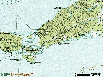
Points of interest:
Notable locations in Chilmark: Dutcher Dock (A), Beetlebung Corner (B), Tri - Town Ambulance (C), Chilmark Fire Department Station 1 Headquarters (D), Chilmark Fire Department Station 2 (E), Chilmark Community Center (F), Chilmark Public Library (G), Chilmark Town Hall (H). Display/hide their locations on the map
Church in Chilmark: Chilmark Community Church (A). Display/hide its location on the map
Cemetery: Chilmark Cemetery (1). Display/hide its location on the map
Lakes, reservoirs, and swamps: Nashaquitsa Pond (A), Menemsha Pond (B), Harlock Pond (C), Black Point Pond (D), Quenames Cove (E), Chilmark Pond (F), Stonewall Pond (G), Bliss Pond (H). Display/hide their locations on the map
Streams, rivers, and creeks: Mill Brook (A). Display/hide its location on the map
Park in Chilmark: Menemsha Hills Reservation (1). Display/hide its location on the map
Beaches: Lucy Vincent Beach (A), Menemsha Beach (B), Squibnocket Beach (C). Display/hide their locations on the map
Birthplace of: John W. Mayhew - College football coach.
| This town: | 2.2 people |
| Massachusetts: | 2.5 people |
| This town: | 60.8% |
| Whole state: | 63.0% |
| This town: | 6.3% |
| Whole state: | 7.0% |
Likely homosexual households (counted as self-reported same-sex unmarried-partner households)
- Lesbian couples: 0.0% of all households
- Gay men: 0.5% of all households
| This town: | 7.6% |
| Whole state: | 9.3% |
| This town: | 3.6% |
| Whole state: | 4.4% |
Banks with branches in Chilmark (2011 data):
- Sovereign Bank, National Association: Chilmark Branch at 517 South Road, branch established on 1965/07/01. Info updated 2012/01/31: Bank assets: $78,146.9 mil, Deposits: $48,042.9 mil, headquarters in Wilmington, DE, positive income, Commercial Lending Specialization, 718 total offices, Holding Company: Banco Santander, S.A.
- Martha's Vineyard Savings Bank: Chilmark Branch at 9 State Road, branch established on 2004/05/03. Info updated 2007/11/16: Bank assets: $526.2 mil, Deposits: $431.2 mil, headquarters in Edgartown, MA, positive income, Mortgage Lending Specialization, 8 total offices
For population 15 years and over in Chilmark:

- Never married: 23.1%
- Now married: 55.5%
- Separated: 2.3%
- Widowed: 5.6%
- Divorced: 13.5%
For population 25 years and over in Chilmark:
- High school or higher: 97.7%
- Bachelor's degree or higher: 57.2%
- Graduate or professional degree: 21.2%
- Unemployed: 2.4%
- Mean travel time to work (commute): 16.3 minutes


| Here: | 9.3 |
| Massachusetts average: | 13.1 |
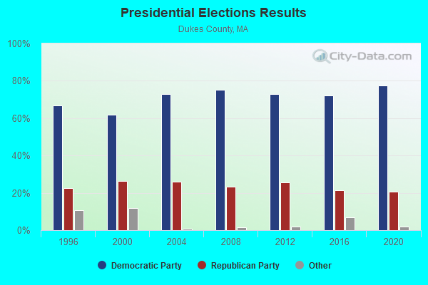
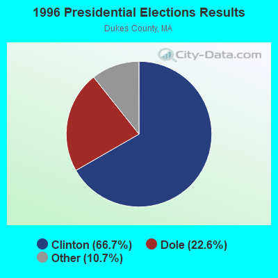
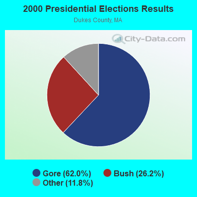
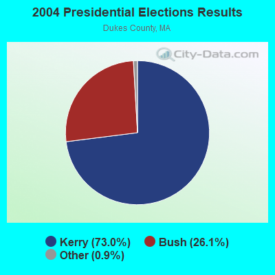
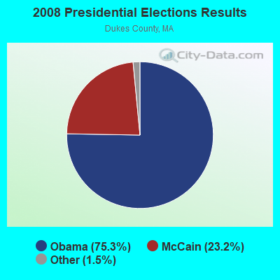
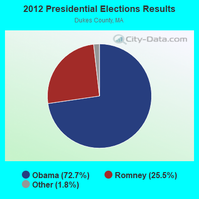
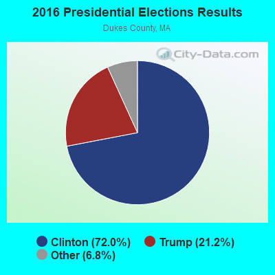
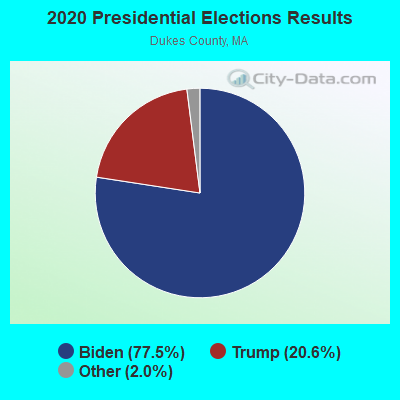
Graphs represent county-level data. Detailed 2008 Election Results
Religion statistics for Chilmark, MA (based on Dukes County data)
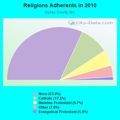
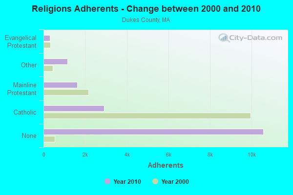
| Religion | Adherents | Congregations |
|---|---|---|
| Catholic | 2,896 | 1 |
| Mainline Protestant | 1,610 | 12 |
| Other | 1,157 | 6 |
| Evangelical Protestant | 310 | 3 |
| None | 10,562 | - |
Food Environment Statistics:
| Dukes County: | 8.41 / 10,000 pop. |
| Massachusetts: | 1.98 / 10,000 pop. |
| This county: | 1.94 / 10,000 pop. |
| Massachusetts: | 2.22 / 10,000 pop. |
| This county: | 1.94 / 10,000 pop. |
| Massachusetts: | 1.77 / 10,000 pop. |
| Dukes County: | 35.59 / 10,000 pop. |
| Massachusetts: | 8.76 / 10,000 pop. |
| Dukes County: | 8.1% |
| Massachusetts: | 8.1% |
| Dukes County: | 19.1% |
| Massachusetts: | 22.5% |
| Dukes County: | 14.6% |
| Massachusetts: | 16.5% |
Strongest AM radio stations in Chilmark:
- WALE (990 AM; 50 kW; GREENVILLE, RI; Owner: NORTH AMERICAN BROADCASTING CO., INC.)
- WEEI (850 AM; 50 kW; BOSTON, MA; Owner: ENTERCOM BOSTON LICENSE, LLC)
- WBZ (1030 AM; 50 kW; BOSTON, MA; Owner: INFINITY BROADCASTING OPERATIONS, INC.)
- WRKO (680 AM; 50 kW; BOSTON, MA; Owner: ENTERCOM BOSTON LICENSE, LLC)
- WCRN (830 AM; 50 kW; WORCESTER, MA; Owner: CARTER BROADCASTING CORPORATION)
- WKOX (1200 AM; 50 kW; FRAMINGHAM, MA; Owner: CAPSTAR TX LIMITED PARTNERSHIP)
- WBSM (1420 AM; 5 kW; NEW BEDFORD, MA; Owner: CITADEL BROADCASTING COMPANY)
- WBIX (1060 AM; 40 kW; NATICK, MA; Owner: LANGER BROADCASTING CORPORATION)
- WWZN (1510 AM; 50 kW; BOSTON, MA; Owner: ROSE CITY RADIO CORPORATION)
- WAMG (890 AM; 25 kW; DEDHAM, MA; Owner: MEGA COMMUNICATIONS OF DEDHAM LICENSEE, LLC)
- WNNZ (640 AM; 50 kW; WESTFIELD, MA; Owner: CLEAR CHANNEL BROADCASTING LICENSES, INC.)
- WPRO (630 AM; 5 kW; PROVIDENCE, RI; Owner: CITADEL BROADCASTING COMPANY)
- WTIC (1080 AM; 50 kW; HARTFORD, CT; Owner: INFINITY RADIO OPERATIONS INC.)
Strongest FM radio stations in Chilmark:
- WCAI (90.1 FM; WOODS HOLE, MA; Owner: WGBH EDUCATIONAL FOUNDATION)
- WMVY (92.7 FM; TISBURY, MA; Owner: ARITAUR COMMUNICATIONS, INC.)
- WCIB (101.9 FM; FALMOUTH, MA; Owner: QANTUM OF CAPE COD LICENSE COMPANY, LLC)
- WCTK (98.1 FM; NEW BEDFORD, MA; Owner: HALL COMMUNICATIONS, INC.)
- WJFD-FM (97.3 FM; NEW BEDFORD, MA; Owner: EDMUND DINIS, TRUSTEE)
- WKKB (100.3 FM; MIDDLETOWN, RI; Owner: CITADEL BROADCASTING COMPANY)
- WFHN (107.1 FM; FAIRHAVEN, MA; Owner: CITADEL BROADCASTING COMPANY)
- WTWV (101.1 FM; MASHPEE, MA; Owner: BOCH BROADCASTING, L.P.)
- WFPB-FM (91.9 FM; FALMOUTH, MA; Owner: UNIVERSITY OF MASSACHUSETTS)
- WSMU-FM (91.1 FM; NORTH DARTMOUTH, MA; Owner: UNIVERSITY OF MASSACHUSETTS)
TV broadcast stations around Chilmark:
- WLWC (Channel 28; NEW BEDFORD, MA; Owner: C-28 FCC LICENSEE SUBSIDIARY, LLC)
- WLNE-TV (Channel 6; NEW BEDFORD, MA; Owner: FREEDOM BROADCASTING OF SOUTHERN NEW ENGLAND, INC.)
Chilmark fatal accident list:
Jan 12, 2018 07:54 AM, Middle Rd, Tea Ln, Lat: 41.368364, Lon: -70.710894, Vehicles: 1, Persons: 3, Fatalities: 1, Drunk persons involved: 1
Apr 24, 2018 07:00 PM, North Rd, Brickyard Rd, Lat: 41.375797, Lon: -70.731617, Vehicles: 1, Persons: 1, Fatalities: 1, Drunk persons involved: 1
Jul 2, 2014 12:30 AM, South Road, Lat: 41.346517, Lon: -70.716650, Vehicles: 2, Persons: 4, Fatalities: 1
Jun 5, 1981 08:45 PM, Vehicles: 1, Persons: 1, Fatalities: 1, Drunk persons involved: 1
- National Bridge Inventory (NBI) Statistics
- 1Number of bridges
- 7ft / 1.6mTotal length
- $982,000Total costs
- 6,400Total average daily traffic
- 1,152Total average daily truck traffic
- 13,424Total future (year 2031) average daily traffic
FCC Registered Cell Phone Towers:
1 (See the full list of FCC Registered Cell Phone Towers in Chilmark)FCC Registered Antenna Towers:
23 (See the full list of FCC Registered Antenna Towers)FCC Registered Broadcast Land Mobile Towers:
3- Cross Rd (Lat: 41.344000 Lon: -70.905028), Structure height: 12 m, Call Sign: WNSZ366,
Assigned Frequencies: 158.940 MHz, Grant Date: 08/14/2015, Expiration Date: 08/13/2025, Registrant: Bardwell Elect, Tisbury, MA 02568, Phone: (508) 693-1486, Email:
- Off Middle Road (Lat: 41.354833 Lon: -70.735028), Type: Tower, Structure height: 9.1 m, Overall height: 12.1 m, Call Sign: WQAS838,
Assigned Frequencies: 154.325 MHz, Grant Date: 06/03/2014, Expiration Date: 07/30/2024, Certifier: Mike Mccormack, Registrant: V-Comm Telecommunications Engineering, 2540 Us Highway 130, Suite 101, Cranbury, NJ 08512, Phone: (609) 655-1200, Fax: (609) 409-1927, Email:
- 34 Black Smith Valley Road (Lat: 41.319389 Lon: -70.769917), Type: Bant, Structure height: 8 m, Overall height: 10 m, Call Sign: WQGX574,
Assigned Frequencies: 153.350 MHz, Grant Date: 05/16/2017, Expiration Date: 05/15/2027, Certifier: Doug Liman, Registrant: Cara Enterprises Inc, Las Vegas, NV 89140-0124, Phone: (702) 838-9728, Fax: (702) 363-4607, Email:
FCC Registered Microwave Towers:
1- PEEKED HILL, 30 Peaked Hill Rd (Lat: 41.355417 Lon: -70.735222), Type: Mtower, Structure height: 33.5 m, Call Sign: WRFA388, Licensee ID: L00040423,
Assigned Frequencies: 6271.36 MHz, 6271.36 MHz, 6271.36 MHz, 6271.36 MHz, 6271.36 MHz, 6271.36 MHz, 6271.36 MHz, 6271.36 MHz, 6212.06 MHz, 6212.06 MHz... (+6 more), Grant Date: 01/14/2020, Expiration Date: 01/14/2030, Certifier: Anthony Gould, Registrant: Dukes County Sheriffs Office, 9 Flight Path, Vineyard Haven, MA 02568, Phone: (508) 627-1212, Fax: (508) 693-7671, Email:
FCC Registered Amateur Radio Licenses:
8 (See the full list of FCC Registered Amateur Radio Licenses in Chilmark)FAA Registered Aircraft:
8 (See the full list of FAA Registered Aircraft in Chilmark)
- 52.0%Fuel oil, kerosene, etc.
- 26.0%Bottled, tank, or LP gas
- 10.1%Wood
- 9.7%Electricity
- 0.7%Utility gas
- 0.7%Coal or coke
- 0.7%Other fuel

- 43.7%Fuel oil, kerosene, etc.
- 30.1%Bottled, tank, or LP gas
- 14.6%Wood
- 11.7%Electricity
Chilmark compared to Massachusetts state average:
- Median house value above state average.
- Unemployed percentage significantly below state average.
- Black race population percentage significantly below state average.
- Hispanic race population percentage significantly below state average.
- Median age significantly above state average.
- Foreign-born population percentage significantly below state average.
- Length of stay since moving in significantly above state average.
- Number of rooms per house significantly below state average.
- House age significantly below state average.
- Number of college students below state average.
- Percentage of population with a bachelor's degree or higher above state average.
Chilmark on our top lists:
- #9 on the list of "Top 101 larger cities with the lowest real estate taxes percentage (population 50,000+)"
- #30 on the list of "Top 100 cities with highest ratio of median house value to median household income"
- #89 on the list of "Top 100 cities with highest median house value"
- #12 (02535) on the list of "Top 101 zip codes with the largest percentage of taxpayers reporting profit/loss from business in 2012 (pop 1,000+)"
- #71 on the list of "Top 101 counties with the highest Ozone (1-hour) air pollution readings in 2012 (ppm)"
- #73 on the list of "Top 101 counties with highest percentage of residents voting for Obama (Democrat) in the 2012 Presidential Election"

|
Total of 4 patent applications in 2008-2024.