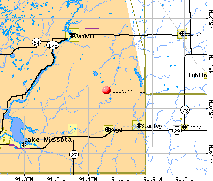
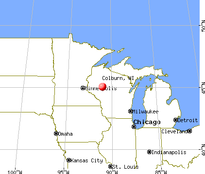
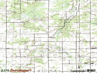
Colburn, Wisconsin
Submit your own pictures of this town and show them to the world
- OSM Map
- General Map
- Google Map
- MSN Map
Population change since 2000: +17.7%
| Males: 443 | |
| Females: 413 |
| Median resident age: | 43.8 years |
| Wisconsin median age: | 42.6 years |
Zip codes: 54726.
| Colburn: | $67,594 |
| WI: | $70,996 |
Estimated per capita income in 2022: $33,868 (it was $17,068 in 2000)
Colburn town income, earnings, and wages data
Estimated median house or condo value in 2022: $220,329 (it was $83,200 in 2000)
| Colburn: | $220,329 |
| WI: | $252,800 |
Detailed information about poverty and poor residents in Colburn, WI


- 83697.7%White alone
- 101.2%Two or more races
- 40.5%Hispanic
- 30.4%American Indian alone
- 30.4%Asian alone

Races in Colburn detailed stats: ancestries, foreign born residents, place of birth
 Recent articles from our blog. Our writers, many of them Ph.D. graduates or candidates, create easy-to-read articles on a wide variety of topics.


Latest news from Colburn, WI collected exclusively by city-data.com from local newspapers, TV, and radio stations
Ancestries: German (42.2%), Polish (21.2%), Norwegian (16.5%), Czech (8.3%), Irish (6.9%), French (5.8%).
Current Local Time: CST time zone
Elevation: 1128 feet
Land area: 65.0 square miles.
Population density: 13 people per square mile (very low).
5 residents are foreign born
| This town: | 0.7% |
| Wisconsin: | 3.6% |
| Colburn town: | 1.2% ($1,021) |
| Wisconsin: | 2.0% ($2,245) |
Nearest city with pop. 50,000+: Eau Claire, WI  (31.4 miles , pop. 61,704).
Nearest city with pop. 200,000+: St. Paul, MN (104.2 miles , pop. 287,151).
Nearest city with pop. 1,000,000+: Chicago, IL (280.0 miles , pop. 2,896,016).
Nearest cities:
), ), ), ), )Latitude: 45.10 N, Longitude: 90.99 W
Area code commonly used in this area: 715


| Here: | 3.5% |
| Wisconsin: | 2.7% |

- Agriculture, forestry, fishing & hunting (26.2%)
- Health care (8.6%)
- Construction (8.3%)
- Educational services (8.0%)
- Accommodation & food services (6.5%)
- Public administration (4.2%)
- Food (3.6%)

- Agriculture, forestry, fishing & hunting (29.6%)
- Construction (13.1%)
- Accommodation & food services (6.6%)
- Public administration (5.2%)
- Administrative & support & waste management services (3.8%)
- Motor vehicle & parts dealers (3.3%)
- Food (3.3%)

- Agriculture, forestry, fishing & hunting (20.3%)
- Educational services (18.7%)
- Health care (18.7%)
- Computer & electronic products (6.5%)
- Accommodation & food services (6.5%)
- Social assistance (4.9%)
- Food (4.1%)

- Farmers and farm managers (21.7%)
- Nursing, psychiatric, and home health aides (4.2%)
- Vehicle and mobile equipment mechanics, installers, and repairers (3.9%)
- Driver/sales workers and truck drivers (3.6%)
- Metal workers and plastic workers (3.6%)
- Construction traders workers except carpenters, electricians, painters, plumbers, and construction laborers (3.3%)
- Agricultural workers, including supervisors (3.3%)

- Farmers and farm managers (24.9%)
- Vehicle and mobile equipment mechanics, installers, and repairers (6.1%)
- Driver/sales workers and truck drivers (5.6%)
- Construction traders workers except carpenters, electricians, painters, plumbers, and construction laborers (5.2%)
- Laborers and material movers, hand (4.2%)
- Metal workers and plastic workers (3.8%)
- Other production occupations, including supervisors (2.8%)

- Farmers and farm managers (16.3%)
- Nursing, psychiatric, and home health aides (11.4%)
- Preschool, kindergarten, elementary, and middle school teachers (7.3%)
- Cooks and food preparation workers (4.9%)
- Cashiers (4.9%)
- Agricultural workers, including supervisors (4.1%)
- Other teachers, instructors, education, training, and library occupations (3.3%)
Average climate in Colburn, Wisconsin
Based on data reported by over 4,000 weather stations


(lower is better)

Air Quality Index (AQI) level in 2023 was 82.8. This is about average.
| City: | 82.8 |
| U.S.: | 72.6 |

Ozone [ppb] level in 2023 was 39.2. This is about average. Closest monitor was 18.9 miles away from the city center.
| City: | 39.2 |
| U.S.: | 33.3 |

Particulate Matter (PM2.5) [µg/m3] level in 2022 was 6.03. This is better than average. Closest monitor was 20.7 miles away from the city center.
| City: | 6.03 |
| U.S.: | 8.11 |
Tornado activity:
Colburn-area historical tornado activity is slightly below Wisconsin state average. It is 1% smaller than the overall U.S. average.
On 6/4/1958, a category F4 (max. wind speeds 207-260 mph) tornado 14.3 miles away from the Colburn town center killed 3 people and injured 50 people and caused between $50,000 and $500,000 in damages.
On 6/4/1958, a category F5 (max. wind speeds 261-318 mph) tornado 33.3 miles away from the town center killed 21 people and injured 74 people and caused between $5,000,000 and $50,000,000 in damages.
Earthquake activity:
Colburn-area historical earthquake activity is significantly above Wisconsin state average. It is 72% smaller than the overall U.S. average.On 7/9/1975 at 14:54:15, a magnitude 4.6 (4.6 MB, Class: Light, Intensity: IV - V) earthquake occurred 248.4 miles away from Colburn center
On 6/28/2004 at 06:10:52, a magnitude 4.2 (4.2 MW, Depth: 6.2 mi) earthquake occurred 272.8 miles away from Colburn center
On 6/5/1993 at 01:24:53, a magnitude 4.1 (4.1 LG, Depth: 6.2 mi) earthquake occurred 260.5 miles away from Colburn center
On 2/10/2010 at 09:59:35, a magnitude 3.8 (3.8 MW, Depth: 6.2 mi, Class: Light, Intensity: II - III) earthquake occurred 250.0 miles away from the city center
On 2/7/2020 at 18:30:28, a magnitude 3.3 (3.3 ML) earthquake occurred 184.3 miles away from the city center
On 1/9/2020 at 18:16:48, a magnitude 3.3 (3.3 MB) earthquake occurred 187.6 miles away from the city center
Magnitude types: regional Lg-wave magnitude (LG), body-wave magnitude (MB), local magnitude (ML), moment magnitude (MW)
Natural disasters:
The number of natural disasters in Chippewa County (10) is smaller than the US average (15).Major Disasters (Presidential) Declared: 8
Emergencies Declared: 2
Causes of natural disasters: Floods: 7, Storms: 6, Tornadoes: 2, Drought: 1, Hurricane: 1, Mudslide: 1, Other: 1 (Note: some incidents may be assigned to more than one category).
Hospitals and medical centers near Colburn:
- CORNELL AREA CARE CTR (Nursing Home, about 9 miles away; CORNELL, WI)
- GILMAN CARE CENTER, LLC (Nursing Home, about 10 miles away; GILMAN, WI)
- DAVITA - MEADOW LANE DIALYSIS (Dialysis Facility, about 11 miles away; STANLEY, WI)
- OUR LADY OF VICTORY HSPTL Critical Access Hospitals (about 11 miles away; STANLEY, WI)
- OAKBROOK HLTH AND REHAB (Nursing Home, about 14 miles away; THORP, WI)
Colleges/universities with over 2000 students nearest to Colburn:
- University of Wisconsin-Eau Claire (about 33 miles; Eau Claire, WI; Full-time enrollment: 10,143)
- Chippewa Valley Technical College (about 33 miles; Eau Claire, WI; FT enrollment: 4,038)
- University of Wisconsin-Stout (about 49 miles; Menomonie, WI; FT enrollment: 8,120)
- Wisconsin Indianhead Technical College (about 64 miles; Shell Lake, WI; FT enrollment: 2,414)
- Northcentral Technical College (about 67 miles; Wausau, WI; FT enrollment: 3,356)
- Mid-State Technical College (about 77 miles; Wisconsin Rapids, WI; FT enrollment: 2,128)
- Winona State University (about 80 miles; Winona, MN; FT enrollment: 8,397)
Points of interest:
Notable location: Shakal Farm (A). Display/hide its location on the map
Cemetery: Yellow River Cemetery (1). Display/hide its location on the map
Lakes and reservoirs: Pike Lake (A), Withrow Lake (B), Otter Lake 27 (C), Otter Lake (D). Display/hide their locations on the map
Creeks: Otter Creek (A), Hay Creek (B), Elder Creek (C), Christmas Creek (D), Pike Creek (E). Display/hide their locations on the map
| This town: | 2.6 people |
| Wisconsin: | 2.4 people |
| This town: | 69.0% |
| Whole state: | 64.4% |
| This town: | 6.7% |
| Whole state: | 7.3% |
Likely homosexual households (counted as self-reported same-sex unmarried-partner households)
- Lesbian couples: 0.3% of all households
- Gay men: 0.0% of all households
| This town: | 10.2% |
| Whole state: | 8.7% |
| This town: | 4.3% |
| Whole state: | 3.7% |
For population 15 years and over in Colburn:

- Never married: 21.9%
- Now married: 65.7%
- Separated: 0.0%
- Widowed: 4.1%
- Divorced: 8.3%
For population 25 years and over in Colburn:
- High school or higher: 83.7%
- Bachelor's degree or higher: 9.0%
- Graduate or professional degree: 3.2%
- Unemployed: 4.0%
- Mean travel time to work (commute): 29.1 minutes


| Here: | 9.4 |
| Wisconsin average: | 11.0 |
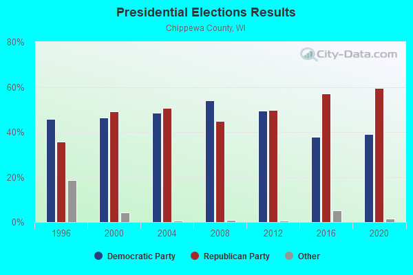
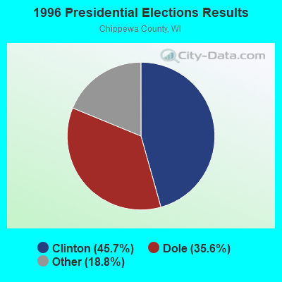
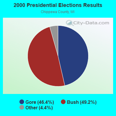
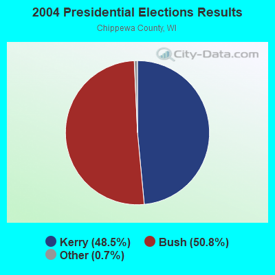
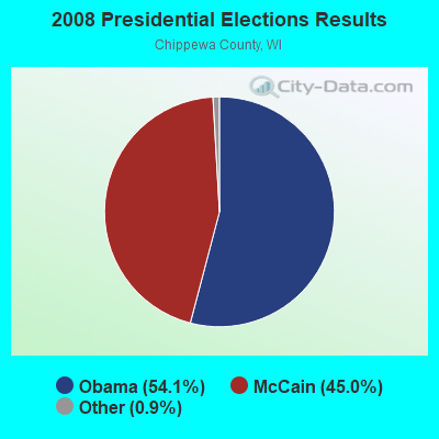
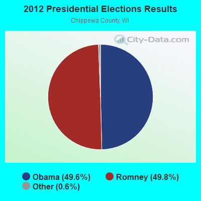
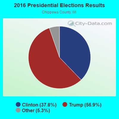
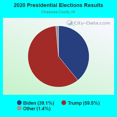
Graphs represent county-level data. Detailed 2008 Election Results
Religion statistics for Colburn, WI (based on Chippewa County data)
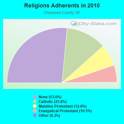
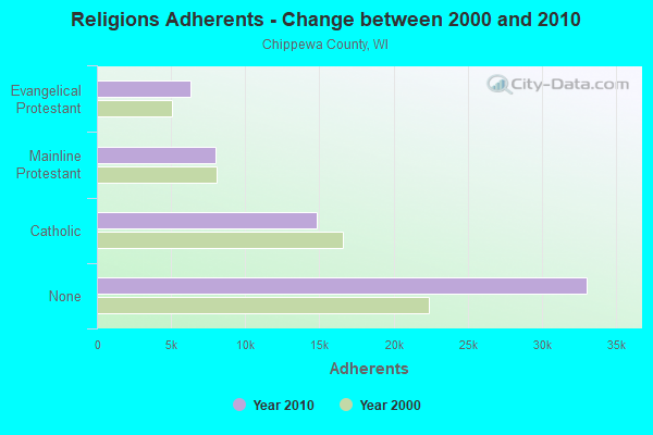
| Religion | Adherents | Congregations |
|---|---|---|
| Catholic | 14,850 | 12 |
| Mainline Protestant | 7,989 | 28 |
| Evangelical Protestant | 6,296 | 42 |
| Other | 201 | 4 |
| Orthodox | 25 | 1 |
| None | 33,054 | - |
Food Environment Statistics:
| Chippewa County: | 2.00 / 10,000 pop. |
| Wisconsin: | 1.86 / 10,000 pop. |
| Chippewa County: | 0.17 / 10,000 pop. |
| Wisconsin: | 0.11 / 10,000 pop. |
| Chippewa County: | 0.50 / 10,000 pop. |
| Wisconsin: | 0.38 / 10,000 pop. |
| This county: | 4.83 / 10,000 pop. |
| Wisconsin: | 4.12 / 10,000 pop. |
| Chippewa County: | 8.67 / 10,000 pop. |
| Wisconsin: | 8.64 / 10,000 pop. |
| Chippewa County: | 7.5% |
| Wisconsin: | 7.6% |
| Chippewa County: | 28.4% |
| State: | 27.5% |
| Here: | 11.5% |
| Wisconsin: | 13.0% |
Strongest AM radio stations in Colburn:
- WSPT (1010 AM; 50 kW; STEVENS POINT, WI)
- WEAQ (1150 AM; 5 kW; CHIPPEWA FALLS, WI; Owner: MAVERICK MEDIA OF EAU CLAIRE LICENSE LLC)
- WAYY (790 AM; 5 kW; EAU CLAIRE, WI; Owner: MAVERICK MEDIA OF EAU CLAIRE LICENSE LLC)
- WSAU (550 AM; 20 kW; WAUSAU, WI; Owner: WRIG, INC.)
- WOGO (680 AM; 2 kW; HALLIE, WI; Owner: STEWARDS OF SOUND, INC.)
- WEBC (560 AM; 50 kW; DULUTH, MN)
- WMEQ (880 AM; 10 kW; MENOMONIE, WI; Owner: CAPSTAR TX LIMITED PARTNERSHIP)
- WCTS (1030 AM; 50 kW; MAPLEWOOD, MN; Owner: CNTL. BAPT. THEO/AL SEMI MINNEAPOLIS)
- WCCO (830 AM; 50 kW; MINNEAPOLIS, MN; Owner: INFINITY MEDIA CORPORATION)
- KSTP (1500 AM; 50 kW; ST. PAUL, MN; Owner: KSTP-AM, LLC (DELAWARE))
- KFAN (1130 AM; 50 kW; MINNEAPOLIS, MN; Owner: AMFM RADIO LICENSES, L.L.C.)
- KTIS (900 AM; 25 kW; MINNEAPOLIS, MN; Owner: NORTHWESTERN COLLEGE)
- WCCN (1370 AM; 5 kW; NEILLSVILLE, WI; Owner: CENTRAL WISCONSIN BROADCASTING, INC.)
Strongest FM radio stations in Colburn:
- WWIB (103.7 FM; HALLIE, WI; Owner: STEWARDS OF SOUND, INC.)
- WAXX (104.5 FM; EAU CLAIRE, WI; Owner: MAVERICK MEDIA OF EAU CLAIRE LICENSE LLC)
- WQRB (95.1 FM; BLOOMER, WI; Owner: CAPSTAR TX LIMITED PARTNERSHIP)
- WHWC (88.3 FM; MENOMONIE, WI; Owner: STATE OF WISCONSIN - EDUCATIONAL COMMUNICATIONS BOARD)
- WMEQ-FM (92.1 FM; MENOMONIE, WI; Owner: CAPSTAR TX LIMITED PARTNERSHIP)
- WUEC (89.7 FM; EAU CLAIRE, WI; Owner: BOARD OF REGENTS, UNIVERSITY OF WISCONSIN SYSTEM)
- WDRK (99.9 FM; CORNELL, WI; Owner: MAVERICK MEDIA OF EAU CLAIRE LICENSE LLC)
- WCFW (105.7 FM; CHIPPEWA FALLS, WI; Owner: BUSHLAND RADIO SPECIALTIES/WCFW)
- WBIZ-FM (100.7 FM; EAU CLAIRE, WI; Owner: CAPSTAR TX LIMITED PARTNERSHIP)
- WJBL (93.1 FM; LADYSMITH, WI; Owner: FLAMBEAU BROADCASTING CO., INC.)
TV broadcast stations around Colburn:
- WEAU-TV (Channel 13; EAU CLAIRE, WI; Owner: WEAU LICENSEE CORP.)
- WQOW-TV (Channel 18; EAU CLAIRE, WI; Owner: WXOW-WQOW TELEVISION, INC.)
- WHWC-TV (Channel 28; MENOMONIE, WI; Owner: STATE OF WISCONSIN - EDUCATIONAL COMMUNICATIONS BOARD)
- National Bridge Inventory (NBI) Statistics
- 14Number of bridges
- 135ft / 40.5mTotal length
- $999,000Total costs
- 24,564Total average daily traffic
- 2,136Total average daily truck traffic
- 27,013Total future (year 2039) average daily traffic

- New bridges - historical statistics
- 11910-1919
- 31930-1939
- 31940-1949
- 11950-1959
- 21960-1969
- 11980-1989
- 11990-1999
- 22000-2009

- 44.1%Bottled, tank, or LP gas
- 34.1%Wood
- 17.9%Fuel oil, kerosene, etc.
- 3.1%Electricity
- 0.9%Other fuel

- 40.0%Bottled, tank, or LP gas
- 31.4%Fuel oil, kerosene, etc.
- 28.6%Wood
Colburn compared to Wisconsin state average:
- Unemployed percentage significantly below state average.
- Black race population percentage significantly below state average.
- Hispanic race population percentage significantly below state average.
- Foreign-born population percentage significantly below state average.
- Renting percentage significantly below state average.
- Length of stay since moving in significantly above state average.
- Number of rooms per house significantly below state average.
- House age significantly below state average.
- Number of college students below state average.
- Percentage of population with a bachelor's degree or higher significantly below state average.