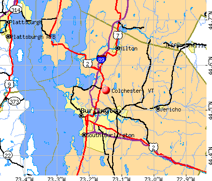
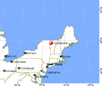
Colchester, Vermont
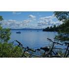
Colchester: Biking: Malletts Bay on The Colchester Causeway
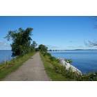
Colchester: Causeway
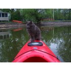
Colchester: My cat Fuego, who loves to Kayak in the waters near the Causeway and Mills Point
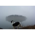
Colchester: Looking at Baxter, looking at Law Island off the Causeway
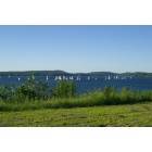
Colchester: Sailing Regatta in Malletts Bay
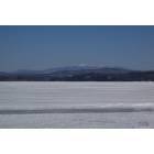
Colchester: Malletts Bay Frozen, looking at the Bay rim.

Colchester: Sunset over Malletts Bay
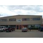
Colchester: Main office for Premier Bus Lines
- add
your


Submit your own pictures of this town and show them to the world
- OSM Map
- General Map
- Google Map
- MSN Map
Population change since 2000: +0.5%
 |
| Males: 8,468 | |
| Females: 8,599 |
| Median resident age: | 35.4 years |
| Vermont median age: | 45.8 years |
Zip codes: 05446.
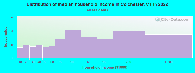
| Colchester: | $94,517 |
| VT: | $73,991 |
Estimated per capita income in 2022: $43,992 (it was $22,472 in 2000)
Colchester town income, earnings, and wages data
Estimated median house or condo value in 2022: $406,693 (it was $131,300 in 2000)
| Colchester: | $406,693 |
| VT: | $304,700 |
Mean prices in 2022: all housing units: $491,172; detached houses: $528,845; townhouses or other attached units: $365,306; in 2-unit structures: $386,479; in 3-to-4-unit structures: over $1,000,000; in 5-or-more-unit structures: $298,866; mobile homes: $83,873
Detailed information about poverty and poor residents in Colchester, VT


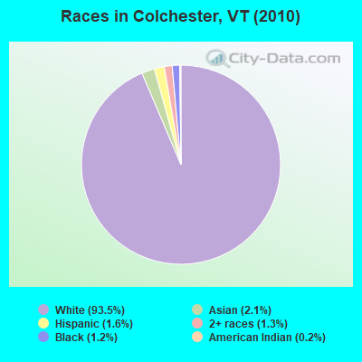
- 15,96093.5%White alone
- 3582.1%Asian alone
- 2701.6%Hispanic
- 2271.3%Two or more races
- 2001.2%Black alone
- 420.2%American Indian alone
- 50.03%Native Hawaiian and Other
Pacific Islander alone - 50.03%Other race alone
Races in Colchester detailed stats: ancestries, foreign born residents, place of birth
According to our research of Vermont and other state lists, there were 23 registered sex offenders living in Colchester, Vermont as of April 25, 2024.
The ratio of all residents to sex offenders in Colchester is 742 to 1.
The ratio of registered sex offenders to all residents in this city is lower than the state average.
Type |
2009 |
2010 |
2011 |
2012 |
2013 |
2014 |
2015 |
2016 |
2017 |
2018 |
2019 |
2020 |
2021 |
2022 |
|---|---|---|---|---|---|---|---|---|---|---|---|---|---|---|
| Murders (per 100,000) | 0 (0.0) | 0 (0.0) | 0 (0.0) | 0 (0.0) | 0 (0.0) | 0 (0.0) | 0 (0.0) | 0 (0.0) | 0 (0.0) | 0 (0.0) | 0 (0.0) | 0 (0.0) | 0 (0.0) | 0 (0.0) |
| Rapes (per 100,000) | 1 (5.8) | 5 (29.3) | 5 (29.3) | 2 (11.7) | 1 (5.8) | 0 (0.0) | 4 (22.9) | 11 (63.1) | 9 (51.9) | 6 (34.7) | 10 (57.0) | 4 (23.4) | 5 (29.2) | 12 (67.8) |
| Robberies (per 100,000) | 5 (28.9) | 3 (17.6) | 6 (35.1) | 3 (17.5) | 2 (11.6) | 1 (5.8) | 2 (11.5) | 2 (11.5) | 5 (28.8) | 1 (5.8) | 3 (17.1) | 2 (11.7) | 0 (0.0) | 2 (11.3) |
| Assaults (per 100,000) | 13 (75.3) | 21 (123.0) | 20 (117.1) | 16 (93.3) | 11 (63.6) | 7 (40.4) | 15 (86.0) | 7 (40.1) | 11 (63.4) | 7 (40.4) | 11 (62.7) | 8 (46.7) | 24 (140.3) | 31 (175.0) |
| Burglaries (per 100,000) | 104 (602.1) | 95 (556.6) | 95 (556.0) | 182 (1,061) | 75 (433.8) | 28 (161.4) | 57 (326.6) | 55 (315.4) | 31 (178.6) | 27 (156.0) | 22 (125.4) | 23 (134.3) | 17 (99.4) | 19 (107.3) |
| Thefts (per 100,000) | 438 (2,536) | 477 (2,795) | 498 (2,915) | 419 (2,443) | 279 (1,614) | 98 (565.0) | 227 (1,301) | 270 (1,548) | 268 (1,544) | 182 (1,051) | 209 (1,191) | 231 (1,349) | 224 (1,310) | 304 (1,717) |
| Auto thefts (per 100,000) | 15 (86.8) | 11 (64.5) | 10 (58.5) | 10 (58.3) | 0 (0.0) | 0 (0.0) | 0 (0.0) | 0 (0.0) | 0 (0.0) | 1 (5.8) | 1 (5.7) | 3 (17.5) | 2 (11.7) | 11 (62.1) |
| Arson (per 100,000) | 2 (11.6) | 4 (23.4) | 0 (0.0) | 0 (0.0) | 0 (0.0) | 0 (0.0) | 0 (0.0) | 2 (11.5) | 0 (0.0) | 1 (5.8) | 1 (5.7) | 1 (5.8) | 2 (11.7) | 0 (0.0) |
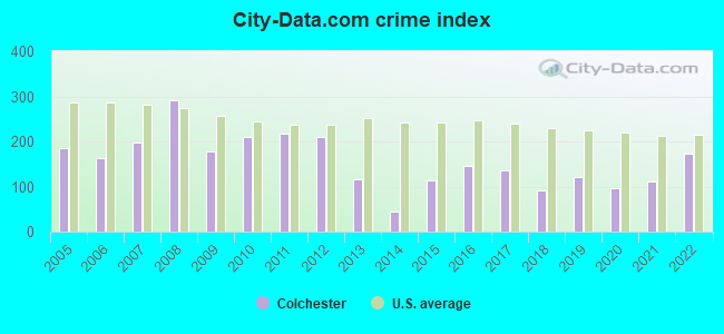
| City-Data.com crime index | 178.9 | 209.2 | 217.5 | 209.9 | 115.7 | 43.7 | 113.9 | 146.0 | 137.1 | 91.0 | 120.1 | 96.3 | 111.7 | 173.7 |
The City-Data.com crime index weighs serious crimes and violent crimes more heavily. Higher means more crime, U.S. average is 246.1. It adjusts for the number of visitors and daily workers commuting into cities.
Crime rate in Colchester detailed stats: murders, rapes, robberies, assaults, burglaries, thefts, arson
Full-time law enforcement employees in 2021, including police officers: 33 (25 officers - 21 male; 4 female).
| Officers per 1,000 residents here: | 1.46 |
| Vermont average: | 1.69 |
 Recent articles from our blog. Our writers, many of them Ph.D. graduates or candidates, create easy-to-read articles on a wide variety of topics.


 | Lunch delivery in Colchester (1 reply) |
| Luxury Apartments in Burlington (4 replies) |
| Need Advice. May move to Burlington for a Job (9 replies) |
| Long Island to Burlington? (2 replies) |
| Colchester Questions (4 replies) |
| Relocation questions for Lesbian mother of adolescent son (2 replies) |
Latest news from Colchester, VT collected exclusively by city-data.com from local newspapers, TV, and radio stations
Ancestries: Irish (19.8%), French (16.2%), French Canadian (15.9%), English (13.9%), German (8.6%), Italian (7.7%).
Current Local Time: EST time zone
Elevation: 180 feet
Land area: 36.9 square miles.
Population density: 463 people per square mile (low).
754 residents are foreign born (1.4% Europe, 1.3% Asia, 1.1% North America).
| This town: | 4.4% |
| Vermont: | 3.8% |
| Colchester town: | 2.0% ($2,598) |
| Vermont: | 2.0% ($2,196) |
Nearest city with pop. 50,000+: Schenectady, NY  (125.7 miles , pop. 61,821).
Nearest city with pop. 200,000+: Boston, MA (186.5 miles , pop. 589,141).
Nearest city with pop. 1,000,000+: Bronx, NY (257.9 miles , pop. 1,332,650).
Nearest cities:
), ), Latitude: 44.54 N, Longitude: 73.20 W
Area code commonly used in this area: 802

Colchester, Vermont accommodation & food services, waste management - Economy and Business Data
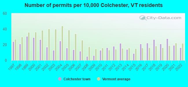
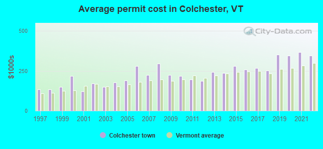
Single-family new house construction building permits:
- 2022: 28 buildings, average cost: $344,700
- 2021: 33 buildings, average cost: $367,300
- 2020: 47 buildings, average cost: $344,800
- 2019: 36 buildings, average cost: $351,800
- 2018: 45 buildings, average cost: $251,600
- 2017: 38 buildings, average cost: $265,700
- 2016: 36 buildings, average cost: $258,400
- 2015: 15 buildings, average cost: $278,900
- 2014: 24 buildings, average cost: $235,500
- 2013: 37 buildings, average cost: $242,900
- 2012: 31 buildings, average cost: $186,100
- 2011: 28 buildings, average cost: $197,000
- 2010: 22 buildings, average cost: $219,200
- 2009: 11 buildings, average cost: $225,100
- 2008: 9 buildings, average cost: $294,600
- 2007: 20 buildings, average cost: $225,200
- 2006: 23 buildings, average cost: $281,300
- 2005: 27 buildings, average cost: $189,700
- 2004: 42 buildings, average cost: $176,300
- 2003: 22 buildings, average cost: $149,800
- 2002: 29 buildings, average cost: $171,000
- 2001: 45 buildings, average cost: $122,100
- 2000: 50 buildings, average cost: $219,400
- 1999: 52 buildings, average cost: $148,200
- 1998: 36 buildings, average cost: $134,200
- 1997: 41 buildings, average cost: $132,800
| Here: | 1.6% |
| Vermont: | 2.0% |
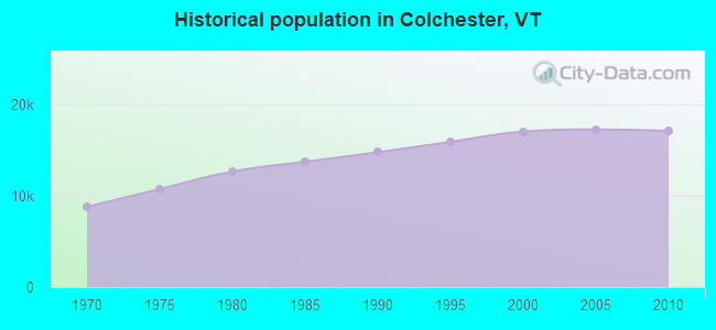
Population change in the 1990s: +2,148 (+14.5%).
- Educational services (12.1%)
- Computer & electronic products (9.8%)
- Health care (8.4%)
- Accommodation & food services (7.0%)
- Construction (5.9%)
- Professional, scientific, technical services (5.8%)
- Finance & insurance (4.0%)

- Computer & electronic products (14.4%)
- Construction (9.6%)
- Educational services (8.0%)
- Accommodation & food services (6.3%)
- Professional, scientific, technical services (5.4%)
- Public administration (3.7%)
- Metal & metal products (2.9%)
- Educational services (16.9%)
- Health care (15.4%)
- Accommodation & food services (7.8%)
- Finance & insurance (6.7%)
- Professional, scientific, technical services (6.3%)
- Computer & electronic products (4.3%)
- Social assistance (3.8%)
- Other management occupations, except farmers and farm managers (4.9%)
- Engineers (3.9%)
- Other office and administrative support workers, including supervisors (3.9%)
- Computer specialists (3.5%)
- Material recording, scheduling, dispatching, and distributing workers (3.5%)
- Retail sales workers, except cashiers (3.4%)
- Secretaries and administrative assistants (3.2%)
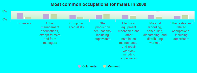
- Engineers (6.4%)
- Other management occupations, except farmers and farm managers (5.7%)
- Computer specialists (4.6%)
- Other production occupations, including supervisors (4.6%)
- Electrical equipment mechanics and other installation, maintenance, and repair workers, including supervisors (4.4%)
- Material recording, scheduling, dispatching, and distributing workers (4.1%)
- Other sales and related occupations, including supervisors (3.7%)
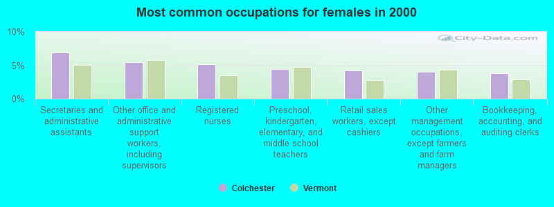
- Secretaries and administrative assistants (6.9%)
- Other office and administrative support workers, including supervisors (5.5%)
- Registered nurses (5.2%)
- Preschool, kindergarten, elementary, and middle school teachers (4.4%)
- Retail sales workers, except cashiers (4.2%)
- Other management occupations, except farmers and farm managers (4.0%)
- Bookkeeping, accounting, and auditing clerks (3.8%)
Average climate in Colchester, Vermont
Based on data reported by over 4,000 weather stations


(lower is better)
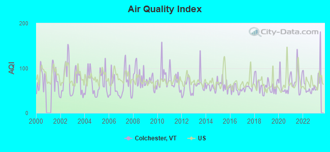
Air Quality Index (AQI) level in 2022 was 56.4. This is better than average.
| City: | 56.4 |
| U.S.: | 72.6 |
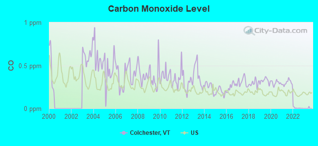
Carbon Monoxide (CO) [ppm] level in 2022 was 0.00585. This is significantly better than average. Closest monitor was 4.4 miles away from the city center.
| City: | 0.00585 |
| U.S.: | 0.25132 |
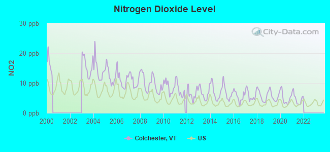
Nitrogen Dioxide (NO2) [ppb] level in 2021 was 4.81. This is about average. Closest monitor was 4.4 miles away from the city center.
| City: | 4.81 |
| U.S.: | 5.11 |
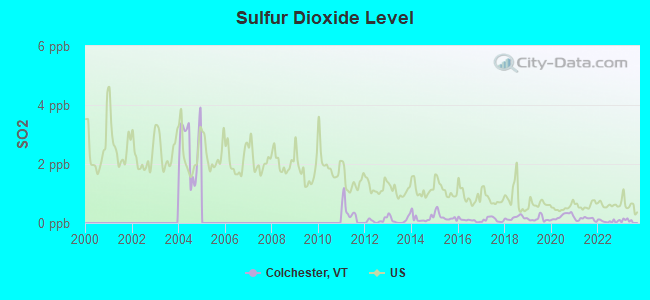
Sulfur Dioxide (SO2) [ppb] level in 2022 was 0.0619. This is significantly better than average. Closest monitor was 4.6 miles away from the city center.
| City: | 0.0619 |
| U.S.: | 1.5147 |
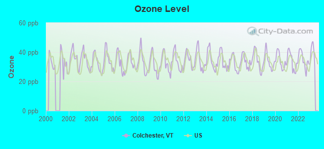
Ozone [ppb] level in 2022 was 34.8. This is about average. Closest monitor was 4.4 miles away from the city center.
| City: | 34.8 |
| U.S.: | 33.3 |
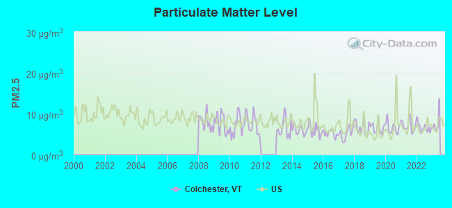
Particulate Matter (PM2.5) [µg/m3] level in 2022 was 6.63. This is better than average. Closest monitor was 4.4 miles away from the city center.
| City: | 6.63 |
| U.S.: | 8.11 |
Earthquake activity:
Colchester-area historical earthquake activity is significantly above Vermont state average. It is 72% smaller than the overall U.S. average.On 4/20/2002 at 10:50:47, a magnitude 5.3 (5.3 ML, Depth: 3.0 mi, Class: Moderate, Intensity: VI - VII) earthquake occurred 24.8 miles away from the city center
On 4/20/2002 at 10:50:47, a magnitude 5.2 (5.2 MB, 4.2 MS, 5.2 MW, 5.0 MW) earthquake occurred 26.0 miles away from the city center
On 10/7/1983 at 10:18:46, a magnitude 5.3 (5.1 MB, 5.3 LG, 5.1 ML) earthquake occurred 69.9 miles away from the city center
On 1/19/1982 at 00:14:42, a magnitude 4.7 (4.5 MB, 4.7 MD, 4.5 LG, Class: Light, Intensity: IV - V) earthquake occurred 107.2 miles away from Colchester center
On 10/16/2012 at 23:12:25, a magnitude 4.7 (4.7 ML, Depth: 10.0 mi) earthquake occurred 142.2 miles away from the city center
On 4/20/2002 at 11:04:42, a magnitude 3.7 (3.7 ML, Depth: 3.1 mi, Class: Light, Intensity: II - III) earthquake occurred 24.6 miles away from the city center
Magnitude types: regional Lg-wave magnitude (LG), body-wave magnitude (MB), duration magnitude (MD), local magnitude (ML), surface-wave magnitude (MS), moment magnitude (MW)
Natural disasters:
The number of natural disasters in Chittenden County (24) is greater than the US average (15).Major Disasters (Presidential) Declared: 18
Emergencies Declared: 2
Causes of natural disasters: Floods: 16, Storms: 14, Heavy Rains: 3, Winter Storms: 2, Hurricane: 1, Ice Storm: 1, Landslide: 1, Snow: 1, Snowstorm: 1, Tropical Storm: 1, Wind: 1, Other: 1 (Note: some incidents may be assigned to more than one category).

Main business address for: GREEN MOUNTAIN POWER CORP (ELECTRIC SERVICES).
Hospitals and medical centers in Colchester:
- VISITING NURSE ASSOCIATION (1110 PRIM ROAD)
- GREEN MOUNTAIN NURSING AND REHABILITATION (475 ETHAN ALLEN AVENUE)
Other hospitals and medical centers near Colchester:
- KINDRED TRANSITIONAL CARE AND REHAB BIRCHWOOD TER (Nursing Home, about 4 miles away; BURLINGTON, VT)
- FANNY ALLEN HOSPITAL (Hospital, about 4 miles away; WINOOSKI, VT)
- STARR FARM NURSING CENTER (Nursing Home, about 4 miles away; BURLINGTON, VT)
- FLETCHER ALLEN HEALTHCARE - MED CTR HOSP OF VT CAMPUS (Dialysis Facility, about 5 miles away; BURLINGTON, VT)
- FLETCHER ALLEN HOSPITAL OF VERMONT Acute Care Hospitals (about 5 miles away; BURLINGTON, VT)
- BURLINGTON HEALTH AND REHAB (Nursing Home, about 5 miles away; BURLINGTON, VT)
- BAYADA NURSES, INC (Home Health Center, about 7 miles away; SO BURLINGTON, VT)
located in Colchester:
See details about located in Colchester, VTAmtrak stations near Colchester:
- 6 miles: BURLINGTON-ESSEX JUNCTION (ESSEX JUNCTION, 29 RAILROAD AVE.) . Services: ticket office, partially wheelchair accessible, enclosed waiting area, public restrooms, public payphones, vending machines, ATM, free short-term parking, free long-term parking, call for car rental service, call for taxi service, public transit connection.
- 13 miles: PORT KENT (RTE. 9 NORTH) - Seasonal Station . Services: free short-term parking, call for taxi service.
- 17 miles: PLATTSBURGH (BRIDGE ST.) . Services: enclosed waiting area, public restrooms, public payphones, free short-term parking, free long-term parking, call for car rental service, call for taxi service.
College/University in Colchester:
Other colleges/universities with over 2000 students near Colchester:
- Community College of Vermont (about 4 miles; Winooski, VT; Full-time enrollment: 3,394)
- University of Vermont (about 5 miles; Burlington, VT; FT enrollment: 11,566)
- Champlain College (about 5 miles; Burlington, VT; FT enrollment: 2,623)
- SUNY College at Plattsburgh (about 17 miles; Plattsburgh, NY; FT enrollment: 5,934)
- Middlebury College (about 37 miles; Middlebury, VT; FT enrollment: 3,077)
- Norwich University (about 39 miles; Northfield, VT; FT enrollment: 4,221)
- Castleton State College (about 65 miles; Castleton, VT; FT enrollment: 2,079)
Public high schools in Colchester:
- COLCHESTER HIGH SCHOOL (Students: 799, Location: 131 LAKER LANE, Grades: 9-12)
- WOODSIDE JUVENILE REHABILITATION CENTER (Students: 18, Location: 26 WOODSIDE DRIVE, Grades: 7-12)
Public elementary/middle schools in Colchester:
- COLCHESTER MIDDLE SCHOOL (Students: 562, Location: 425 BLAKELY ROAD, Grades: 6-8)
- MALLETTS BAY SCHOOL (Students: 496, Location: BLAKELY ROAD, Grades: PK-5)
- PORTERS POINT SCHOOL (Students: 254, Location: 490 PORTERS POINT ROAD, Grades: KG-2)
- UNION MEMORIAL SCHOOL (Students: 247, Location: 253 MAIN STREET, Grades: KG-2)
Points of interest:
Notable locations in Colchester: Winnisquam Orchard (A), Camp Saint Joseph (B), Marble Island Golf and Yacht Club (C), Mallets Bay Yacht Club (D), Malletts Bay Marina (E), Jakes Marina (F), Holy Cross Camp (G), Ponnesoon Knolls Camp (H), Malletts Bay Campground (I), Lone Pine Campsite (J), Camp Norfleet (K), Camp Kiniya (L), Brae Loch (M), The Moorings (N), Town Farm (O), Sunset Drive-In (P), Woodman Hall (Q), Fanny Allen Hospital Library (R), Saint Michael's College Fire And Rescue, Incorporated (S), Colchester Center Volunteer Fire Company - Old Station (T). Display/hide their locations on the map
Shopping Centers: Colchester Shopping Plaza Shopping Center (1), Harbor View Plaza Shopping Center (2). Display/hide their locations on the map
Main business address in Colchester: GREEN MOUNTAIN POWER CORP (A). Display/hide its location on the map
Churches in Colchester include: United Church of Colchester (A), Unification Church (B), Holy Cross Church (C), Our Lady of Grace Church (D), Community Lutheran Church (E), Malletts Bay Congregational Church (F). Display/hide their locations on the map
Cemeteries: Center Cemetery (1), Champlain Cemetery (2), Saint Stephens Cemetery (3), Munson Cemetery (4), Fanny Allen Cemetery (5), Merrill Cemetery (6), Malletts Bay Cemetery (7). Display/hide their locations on the map
Lakes and reservoirs: Lily Pad Pond (A), Colchester Pond (B), Mill Pond (C), Winooski River Reservoir (D). Display/hide their locations on the map
Streams, rivers, and creeks: Pond Brook (A), Winooski River (B), Allen Brook (C), Malletts Creek (D), Indian Brook (E). Display/hide their locations on the map
Park in Colchester: Mallets Bay State Park (1). Display/hide its location on the map
Hotels: Hampton Inn & Conference Center - Burlin (42 Lower Mountain View Drive) (1), Motel 6 (74 South Park Drive) (2), Fairfield Inn Burlington Colchester (84 South Park Drive) (3), Burlington-Days Inn Colchester (23 College Pkwy) (4), Handy's Extended Stay Suites (66 College Parkway) (5). Display/hide their approximate locations on the map
Birthplace of: Ray Collins (baseball) - Baseball player and coach.
Drinking water stations with addresses in Colchester and their reported violations in the past:
COLCHESTER FIRE DISTRICT 2 (Population served: 8,300, Purch surface water):Past health violations:HILLCREST MHP INC (Address: 3880 ROOSEVELT HIGHWAY , Population served: 615, Purch surface water):Past monitoring violations:
- MCL, Average - Between JAN-2012 and MAR-2012, Contaminant: Total Haloacetic Acids (HAA5). Follow-up actions: St Formal NOV issued (MAY-01-2012), St Tech Assistance Visit (MAY-01-2012), St Public Notif requested (MAY-01-2012), St Public Notif received (MAY-21-2012)
- One routine major monitoring violation
Past monitoring violations:SOUTHERN VERMONT ARTS CENTER (Address: 154 BRENTWOOD DR STE 1 , Population served: 400, Groundwater):
- Monitoring and Reporting (DBP) - Between JUL-2013 and SEP-2013, Contaminant: Total Haloacetic Acids (HAA5). Follow-up actions: St Formal NOV issued (NOV-26-2013), St Public Notif requested (NOV-26-2013), St Tech Assistance Visit (NOV-26-2013)
- Monitoring and Reporting (DBP) - Between JUL-2013 and SEP-2013, Contaminant: TTHM. Follow-up actions: St Formal NOV issued (NOV-26-2013), St Public Notif requested (NOV-26-2013), St Tech Assistance Visit (NOV-26-2013)
- Monitoring and Reporting (DBP) - Between JUL-2012 and SEP-2012, Contaminant: Total Haloacetic Acids (HAA5). Follow-up actions: St Formal NOV issued (DEC-13-2012), St Tech Assistance Visit (DEC-13-2012), St Public Notif requested (DEC-13-2012), St Public Notif received (SEP-23-2013)
- Monitoring and Reporting (DBP) - Between JUL-2012 and SEP-2012, Contaminant: TTHM. Follow-up actions: St Formal NOV issued (DEC-13-2012), St Tech Assistance Visit (DEC-13-2012), St Public Notif requested (DEC-13-2012), St Public Notif received (SEP-23-2013)
- Monitoring and Reporting (DBP) - Between APR-2009 and JUN-2009, Contaminant: Total Haloacetic Acids (HAA5). Follow-up actions: St Public Notif requested (SEP-17-2009), St Tech Assistance Visit (SEP-17-2009), St Formal NOV issued (SEP-17-2009), St Compliance achieved (FEB-09-2010), St Public Notif received (AUG-05-2010)
- One other older monitoring violation
Past health violations:NORTH HARBOR (Address: 290 N HARBOR RD , Population served: 220, Groundwater):Past monitoring violations:
- MCL, Monthly (TCR) - In MAR-2013, Contaminant: Coliform. Follow-up actions: St Tech Assistance Visit (MAR-12-2013), St Formal NOV issued (MAR-12-2013), St Boil Water Order (MAR-12-2013), St Public Notif requested (MAR-12-2013), St Public Notif received (MAR-21-2013), St Compliance achieved (APR-05-2013)
- MCL, Monthly (TCR) - In AUG-2012, Contaminant: Coliform. Follow-up actions: St Tech Assistance Visit (AUG-17-2012), St Formal NOV issued (AUG-17-2012), St Public Notif requested (AUG-17-2012), St Boil Water Order (AUG-17-2012), St Compliance achieved (SEP-14-2012)
- MCL, Monthly (TCR) - In OCT-2011, Contaminant: Coliform. Follow-up actions: St Tech Assistance Visit (OCT-25-2011), St Formal NOV issued (OCT-25-2011), St Public Notif requested (OCT-25-2011), St Boil Water Order (OCT-25-2011), St Compliance achieved (DEC-01-2011)
- MCL, Monthly (TCR) - In JUN-2010, Contaminant: Coliform. Follow-up actions: St Tech Assistance Visit (JUL-06-2010), St Formal NOV issued (JUL-06-2010), St Public Notif requested (JUL-06-2010), St Boil Water Order (JUL-06-2010), St Compliance achieved (NOV-04-2010)
- One routine major monitoring violation
- One minor monitoring violation
- 3 regular monitoring violations
Past health violations:CAMP DUDLEY AT KINIYA (Address: 1317 CAMP KINIYA ROAD , Population served: 200, Groundwater):Past monitoring violations:
- MCL, Monthly (TCR) - In AUG-2007, Contaminant: Coliform. Follow-up actions: St Boil Water Order (AUG-08-2007), St Formal NOV issued (AUG-08-2007), St Tech Assistance Visit (AUG-08-2007), St Public Notif requested (AUG-08-2007), St Public Notif received (JUL-01-2008), St Compliance achieved (SEP-25-2009)
- MCL, Monthly (TCR) - In JUL-2006, Contaminant: Coliform. Follow-up actions: St Formal NOV issued (AUG-07-2006), St Boil Water Order (AUG-07-2006), St Tech Assistance Visit (AUG-07-2006), St Public Notif requested (AUG-07-2006), St Compliance achieved (JAN-29-2010)
- Monitoring and Reporting (DBP) - Between JAN-2013 and MAR-2013, Contaminant: Chlorine. Follow-up actions: St Public Notif requested (MAR-20-2013), St Formal NOV issued (MAR-20-2013), St Public Notif received (JUN-26-2013), St Compliance achieved (SEP-30-2013)
- One routine major monitoring violation
- One minor monitoring violation
- One regular monitoring violation
Past monitoring violations:CAMERON PROPERTY (Address: 154 BRENTWOOD DR STE 1 , Population served: 155, Groundwater):
- Monitoring and Reporting (DBP) - Between JUL-2009 and SEP-2009, Contaminant: Chlorine. Follow-up actions: St Public Notif requested (MAR-01-2010), St Formal NOV issued (MAR-01-2010), St Compliance achieved (MAR-16-2011)
- Monitoring of Treatment (SWTR-Filter) - In SEP-2007. Follow-up actions: St Formal NOV issued (OCT-23-2007), St Public Notif requested (OCT-23-2007)
- Monitoring of Treatment (SWTR-Filter) - In JUN-2007. Follow-up actions: St Formal NOV issued (JUL-31-2007), St Public Notif requested (JUL-31-2007)
- 4 routine major monitoring violations
Past monitoring violations:GEORGIA STATION (Address: 336 WATER TOWER CIRCLE SUITE 801 , Population served: 120, Groundwater):
- Initial Tap Sampling for Pb and Cu - In JUL-01-2009, Contaminant: Lead and Copper Rule. Follow-up actions: St Formal NOV issued (NOV-05-2009), St Tech Assistance Visit (NOV-05-2009), St Public Notif requested (NOV-05-2009), St Other (NOV-05-2009), St Compliance achieved (SEP-27-2010)
- 3 routine major monitoring violations
- 84 regular monitoring violations
Past health violations:HOMESTEAD ACRES MHP (Address: 154 BRENTWOOD DR STE 1 , Population served: 81, Groundwater):
- MCL, Monthly (TCR) - In JUN-2012, Contaminant: Coliform. Follow-up actions: St Tech Assistance Visit (JUL-05-2012), St Formal NOV issued (JUL-05-2012), St Boil Water Order (JUL-05-2012), St Public Notif requested (JUL-05-2012), St Public Notif received (JUL-10-2012), St Compliance achieved (JUL-16-2012)
- MCL, Monthly (TCR) - In AUG-2009, Contaminant: Coliform. Follow-up actions: St Boil Water Order (AUG-10-2009), St Formal NOV issued (AUG-10-2009), St Tech Assistance Visit (AUG-10-2009), St Public Notif requested (AUG-10-2009), St Compliance achieved (NOV-08-2010)
- MCL, Monthly (TCR) - In AUG-2006, Contaminant: Coliform. Follow-up actions: St Formal NOV issued (AUG-15-2006), St Public Notif requested (AUG-15-2006), St Public Notif received (SEP-08-2006), St Compliance achieved (NOV-08-2010)
Past health violations:Past monitoring violations:
- MCL, Monthly (TCR) - In SEP-2005, Contaminant: Coliform. Follow-up actions: St Violation/Reminder Notice (SEP-27-2005), St Public Notif requested (SEP-27-2005), St Public Notif received (OCT-10-2005), St Compliance achieved (JAN-29-2010)
- Monitoring and Reporting (DBP) - Between JAN-2012 and MAR-2012, Contaminant: Chlorine. Follow-up actions: St Public Notif requested (MAY-11-2012), St Formal NOV issued (MAY-11-2012), St Public Notif received (MAY-30-2012), St Compliance achieved (DEC-07-2012)
- Monitoring and Reporting (DBP) - Between OCT-2009 and DEC-2009, Contaminant: Chlorine. Follow-up actions: St Public Notif requested (MAR-01-2010), St Formal NOV issued (MAR-01-2010), St Public Notif received (JUN-03-2010), St Compliance achieved (MAR-17-2011)
- Monitoring and Reporting (DBP) - Between JAN-2009 and MAR-2009, Contaminant: Chlorine. Follow-up actions: St Public Notif requested (JUL-15-2009), St Formal NOV issued (JUL-15-2009), St Public Notif received (JUN-03-2010), St Compliance achieved (MAR-17-2011)
- Monitoring and Reporting (DBP) - Between OCT-2008 and DEC-2008, Contaminant: Chlorine. Follow-up actions: St Public Notif requested (APR-07-2009), St Formal NOV issued (APR-07-2009), St Public Notif received (JUN-26-2009), St Compliance achieved (SEP-25-2009)
- Monitoring and Reporting (DBP) - Between JUL-2008 and SEP-2008, Contaminant: Chlorine. Follow-up actions: St Public Notif requested (APR-07-2009), St Formal NOV issued (APR-07-2009), St Public Notif received (JUN-26-2009), St Compliance achieved (SEP-25-2009)
- One routine major monitoring violation
- One minor monitoring violation
| This town: | 2.4 people |
| Vermont: | 2.3 people |
| This town: | 64.9% |
| Whole state: | 62.5% |
| This town: | 9.6% |
| Whole state: | 9.2% |
Likely homosexual households (counted as self-reported same-sex unmarried-partner households)
- Lesbian couples: 0.7% of all households
- Gay men: 0.4% of all households
| This town: | 6.3% |
| Whole state: | 9.4% |
| This town: | 2.6% |
| Whole state: | 3.6% |
82 people in nursing facilities/skilled-nursing facilities in 2010
People in group quarters in Colchester in 2000:
- 1,592 people in college dormitories (includes college quarters off campus)
- 29 people in religious group quarters
- 3 people in homes for the mentally ill
Banks with branches in Colchester (2011 data):
- People's United Bank: Malletts Bay Branch at 794 West Lakeshore Drive, branch established on 1972/08/21; Colchester-Shaws Branch at 66 Mountain View Drive, Suite 2, branch established on 1997/09/22. Info updated 2012/02/16: Bank assets: $27,319.3 mil, Deposits: $20,835.4 mil, headquarters in Bridgeport, CT, positive income, Commercial Lending Specialization, 374 total offices
- Merchants Bank: Malletts Bay Branch at 22 Bissette Drive, branch established on 1978/05/15. Info updated 2011/12/09: Bank assets: $1,615.1 mil, Deposits: $1,179.4 mil, headquarters in Burlington, VT, positive income, Commercial Lending Specialization, 34 total offices, Holding Company: Merchants Bancshares, Inc.
- RBS Citizens, National Association: Colchester Branch at 73 Prim Road; Ste 7, branch established on 1989/06/30. Info updated 2007/09/19: Bank assets: $106,940.6 mil, Deposits: $75,690.2 mil, headquarters in Providence, RI, positive income, 1135 total offices, Holding Company: Uk Financial Investments Limited
For population 15 years and over in Colchester:
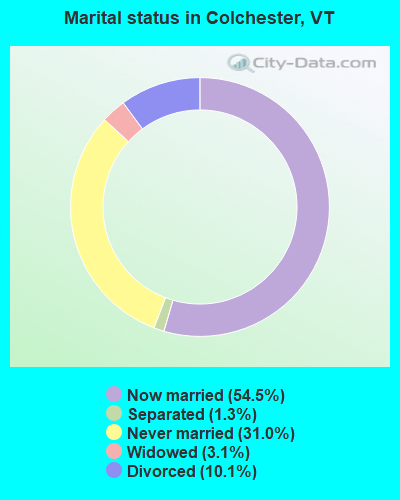
- Never married: 31.0%
- Now married: 54.5%
- Separated: 1.3%
- Widowed: 3.1%
- Divorced: 10.1%
For population 25 years and over in Colchester:
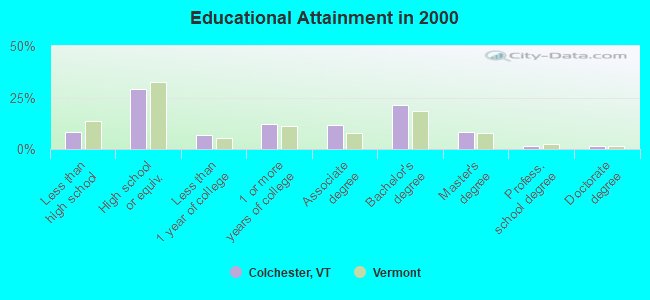
- High school or higher: 91.6%
- Bachelor's degree or higher: 32.5%
- Graduate or professional degree: 11.2%
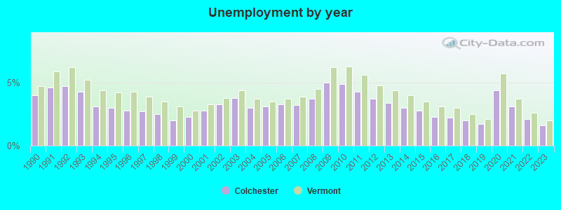
- Unemployed: 6.4%
- Mean travel time to work (commute): 19.7 minutes
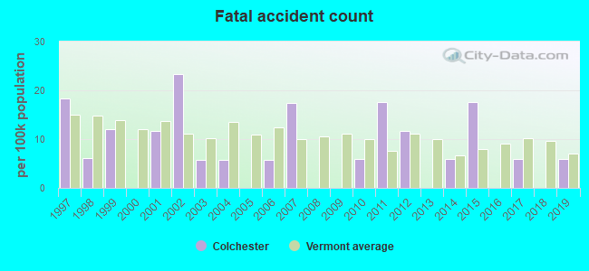
| Here: | 10.2 |
| Vermont average: | 11.7 |
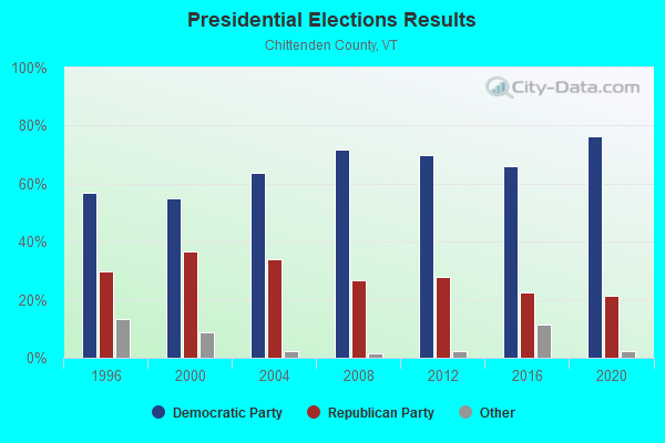
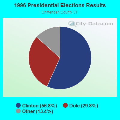
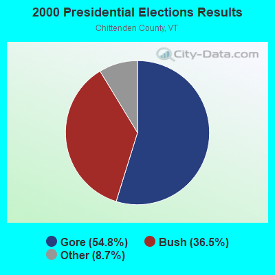
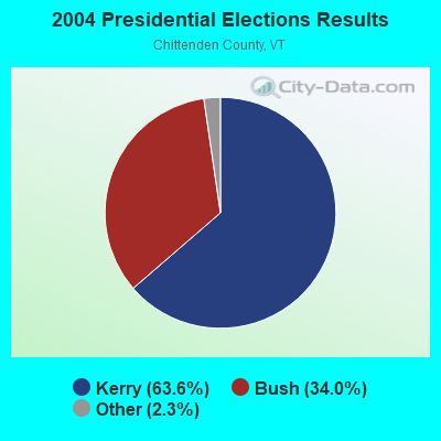

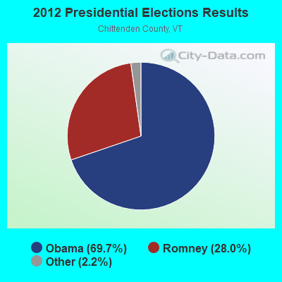
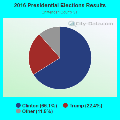
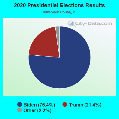
Graphs represent county-level data. Detailed 2008 Election Results
Religion statistics for Colchester, VT (based on Chittenden County data)

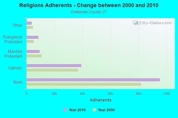
| Religion | Adherents | Congregations |
|---|---|---|
| Catholic | 39,143 | 19 |
| Mainline Protestant | 9,427 | 43 |
| Evangelical Protestant | 8,638 | 43 |
| Other | 3,891 | 20 |
| Orthodox | 100 | 1 |
| None | 95,346 | - |
Food Environment Statistics:
| Chittenden County: | 2.77 / 10,000 pop. |
| Vermont: | 3.84 / 10,000 pop. |
| This county: | 0.07 / 10,000 pop. |
| Vermont: | 0.07 / 10,000 pop. |
| Here: | 1.84 / 10,000 pop. |
| Vermont: | 1.95 / 10,000 pop. |
| Here: | 4.28 / 10,000 pop. |
| State: | 6.40 / 10,000 pop. |
| Chittenden County: | 9.35 / 10,000 pop. |
| Vermont: | 11.52 / 10,000 pop. |
| Chittenden County: | 5.3% |
| State: | 6.8% |
| Here: | 18.7% |
| Vermont: | 22.3% |
| Chittenden County: | 13.8% |
| Vermont: | 13.3% |
| Businesses in Colchester, VT | ||||
| Name | Count | Name | Count | |
|---|---|---|---|---|
| Ace Hardware | 1 | McDonald's | 2 | |
| Burger King | 1 | Motel 6 | 1 | |
| Costco | 1 | New Balance | 2 | |
| Dunkin Donuts | 1 | Quality | 1 | |
| FedEx | 2 | Rite Aid | 1 | |
| GNC | 1 | Shaw's | 1 | |
| Hilton | 1 | UPS | 1 | |
| Lane Furniture | 1 | YMCA | 1 | |
| Marriott | 1 | |||
Strongest AM radio stations in Colchester:
- WVMT (620 AM; 5 kW; BURLINGTON, VT; Owner: SISON BROADCASTING, INC.)
- WVAA (1390 AM; 5 kW; BURLINGTON, VT; Owner: RADIO VERMONT, KDR, LLC)
- WCHP (760 AM; 35 kW; CHAMPLAIN, NY; Owner: CHAMPLAIN RADIO, INC.)
- WEAV (960 AM; 5 kW; PLATTSBURGH, NY; Owner: CLEAR CHANNEL BROADCASTING LICENSES, INC.)
- WTWK (1070 AM; daytime; 5 kW; PLATTSBURGH, NY; Owner: CHAMPLAIN COMMUNICATIONS CORPORATION)
- WJOY (1230 AM; 1 kW; BURLINGTON, VT; Owner: HALL COMMUNICATIONS, INC.)
- WDEV (550 AM; 5 kW; WATERBURY, VT; Owner: RADIO VERMONT, INC.)
- WICY (1490 AM; 50 kW; MALONE, NY; Owner: CARTIER COMMUNICATIONS INC.)
- WGY (810 AM; 50 kW; SCHENECTADY, NY; Owner: CLEAR CHANNEL BROADCASTING LICENSES, INC.)
- WNNZ (640 AM; 50 kW; WESTFIELD, MA; Owner: CLEAR CHANNEL BROADCASTING LICENSES, INC.)
- WIRD (920 AM; 5 kW; LAKE PLACID, NY; Owner: RADIO LAKE PLACID INC)
- WIRY (1340 AM; 1 kW; PLATTSBURGH, NY; Owner: HOMETOWN RADIO INC)
- WRKO (680 AM; 50 kW; BOSTON, MA; Owner: ENTERCOM BOSTON LICENSE, LLC)
Strongest FM radio stations in Colchester:
- WCPV (101.3 FM; ESSEX, NY; Owner: CAPSTAR TX LIMITED PARTNERSHIP)
- WXXX (95.5 FM; SOUTH BURLINGTON, VT; Owner: SISON BROADCASTING, INC.)
- W207AX (89.3 FM; BURLINGTON, VT; Owner: FAMILY STATIONS, INC.)
- WEZF (92.9 FM; BURLINGTON, VT; Owner: CAPSTAR TX LIMITED PARTNERSHIP)
- WVPS (107.9 FM; BURLINGTON, VT; Owner: VERMONT PUBLIC RADIO)
- WCVT (101.7 FM; STOWE, VT; Owner: RADIO VERMONT CLASSICS, L.L.C.)
- WLKC (103.3 FM; WATERBURY, VT; Owner: RADIO BROADCASTING SERVICES, INC.)
- WNCS (104.7 FM; MONTPELIER, VT; Owner: MONTPELIER BROADCASTING, INC.)
- WCEL (91.9 FM; PLATTSBURGH, NY; Owner: WAMC)
- WOKO (98.9 FM; BURLINGTON, VT; Owner: HALL COMMUNICATIONS, INC.)
- WDEV-FM (96.1 FM; WARREN, VT; Owner: RADIO VERMONT, INC.)
- WXZO (96.7 FM; WILLSBORO, NY; Owner: CAPSTAR TX LIMITED PARTNERSHIP)
- WGLY-FM (91.5 FM; BOLTON, VT; Owner: CHRISTIAN MINISTRIES, INC.)
- WIZN (106.7 FM; VERGENNES, VT; Owner: BURLINGTON BROADCASTERS, INC.)
- WRUV (90.1 FM; BURLINGTON, VT; Owner: THE UNIVERSITY OF VERMONT)
- WLFE-FM (102.3 FM; ST. ALBANS, VT; Owner: CHAMPLAIN COMMUNICATIONS CORP.)
- WXLU (88.3 FM; PERU, NY; Owner: THE ST. LAWRENCE UNIVERSITY)
- WWPV-FM (88.7 FM; COLCHESTER, VT; Owner: SAINT MICHAEL'S COLLEGE)
- WBTZ (99.9 FM; PLATTSBURGH, NY; Owner: PLATTSBURGH BROADCASTING CORPORATION)
- WYUL (94.7 FM; CHATEAUGAY, NY; Owner: CARTIER COMMUNICATIONS INC.)
TV broadcast stations around Colchester:
- W51CB (Channel 51; BURLINGTON, VT; Owner: DEEPAK VISWANATH)
- W16AL (Channel 16; BURLINGTON, VT; Owner: TRINITY BROADCASTING NETWORK)
- WPTZ (Channel 5; NORTH POLE, NY; Owner: HEARST-ARGYLE STATIONS, INC.)
- W19BR (Channel 19; MONKTON, VT; Owner: PLATTSBURGH PARTNERS)
- WVNY (Channel 22; BURLINGTON, VT; Owner: C-22 FCC LICENSEE SUBSIDIARY, LLC)
- National Bridge Inventory (NBI) Statistics
- 21Number of bridges
- 571ft / 174mTotal length
- $80,967,000Total costs
- 437,488Total average daily traffic
- 40,119Total average daily truck traffic
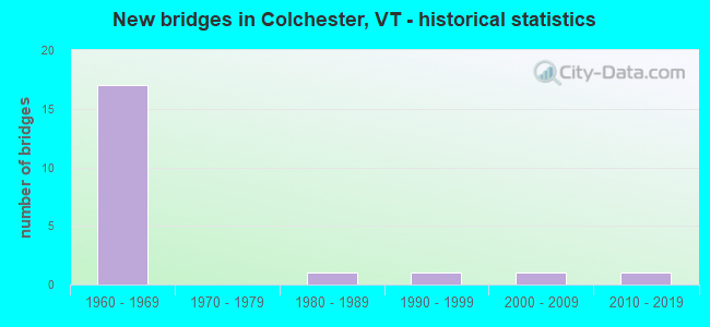
- New bridges - historical statistics
- 171960-1969
- 11980-1989
- 11990-1999
- 12000-2009
- 12010-2019
FCC Registered Antenna Towers: 41 (See the full list of FCC Registered Antenna Towers)
FCC Registered Commercial Land Mobile Towers: 4 (See the full list of FCC Registered Commercial Land Mobile Towers in Colchester, VT)
FCC Registered Broadcast Land Mobile Towers: 16 (See the full list of FCC Registered Broadcast Land Mobile Towers)
FCC Registered Microwave Towers: 24 (See the full list of FCC Registered Microwave Towers in this town)
FCC Registered Paging Towers: 1 (See the full list of FCC Registered Paging Towers)
FCC Registered Amateur Radio Licenses: 108 (See the full list of FCC Registered Amateur Radio Licenses in Colchester)
FAA Registered Aircraft: 23 (See the full list of FAA Registered Aircraft in Colchester)
2002 - 2018 National Fire Incident Reporting System (NFIRS) incidents
- Fire incident types reported to NFIRS in Colchester, VT
- 41444.3%Structure Fires
- 29131.2%Outside Fires
- 14115.1%Mobile Property/Vehicle Fires
- 889.4%Other
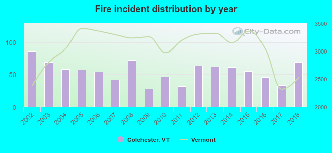 Based on the data from the years 2002 - 2018 the average number of fires per year is 55. The highest number of fires - 86 took place in 2002, and the least - 28 in 2009. The data has a dropping trend.
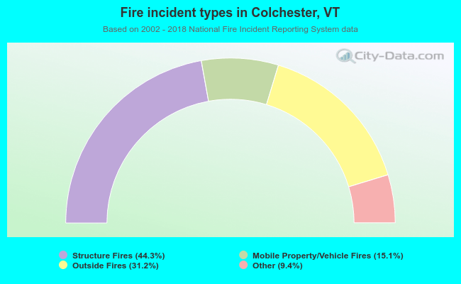 When looking into fire subcategories, the most incidents belonged to: Structure Fires (44.3%), and Outside Fires (31.2%).
Fire-safe hotels and motels in Colchester, Vermont:
- Hampton Inn And Event Center Burlington/Colchester, 42 Lower Mtn View Dr, Colchester, Vermont 05446 , Phone: (802) 655-6177, Fax: (802) 654-7718
- Marriott Residence Inn Burlington Colchester, 71 Rathe Rd, Colchester, Vermont 05446 , Phone: (802) 655-3100, Fax: (802) 655-3160
| Most common first names in Colchester, VT among deceased individuals | ||
| Name | Count | Lived (average) |
|---|---|---|
| Mary | 43 | 84.2 years |
| John | 36 | 74.1 years |
| Robert | 32 | 71.6 years |
| George | 29 | 75.1 years |
| Richard | 26 | 70.8 years |
| William | 23 | 73.8 years |
| Dorothy | 23 | 79.0 years |
| Joseph | 22 | 72.0 years |
| James | 21 | 66.9 years |
| Raymond | 21 | 72.2 years |
| Most common last names in Colchester, VT among deceased individuals | ||
| Last name | Count | Lived (average) |
|---|---|---|
| Brown | 10 | 83.9 years |
| Bessette | 10 | 76.4 years |
| Cross | 10 | 71.0 years |
| Sweeney | 10 | 78.0 years |
| Martin | 10 | 74.4 years |
| Thompson | 9 | 77.2 years |
| Bean | 9 | 71.3 years |
| Charbonneau | 7 | 72.8 years |
| Smith | 7 | 77.5 years |
| Shepard | 7 | 71.9 years |
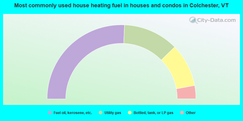
- 51.3%Fuel oil, kerosene, etc.
- 24.0%Utility gas
- 18.9%Bottled, tank, or LP gas
- 3.1%Wood
- 1.9%Electricity
- 0.8%Other fuel
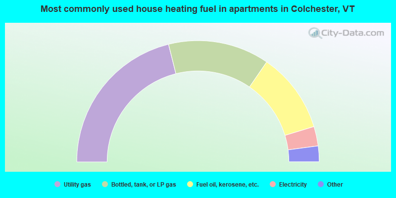
- 42.2%Utility gas
- 27.0%Bottled, tank, or LP gas
- 21.4%Fuel oil, kerosene, etc.
- 5.2%Electricity
- 2.2%Other fuel
- 1.6%Wood
- 0.4%No fuel used
Colchester compared to Vermont state average:
- Unemployed percentage below state average.
- Median age significantly below state average.
- Length of stay since moving in significantly above state average.
- Number of rooms per house significantly below state average.
- House age significantly below state average.
- Number of college students above state average.
Colchester on our top lists:
- #10 on the list of "Top 101 cities with largest percentage of males in industries: computer and electronic products (population 5,000+)"
- #36 on the list of "Top 101 cities with largest percentage of males in occupations: drafters, engineering, and mapping technicians (population 5,000+)"
- #51 on the list of "Top 101 cities with largest percentage of males in industries: book stores and news dealers (population 5,000+)"
- #56 on the list of "Top 101 cities with largest percentage of females in industries: furniture and home furnishings, and household appliance stores (population 5,000+)"
- #59 on the list of "Top 101 cities with largest percentage of males in occupations: other teachers and instructors, education, training, and library occupations (population 5,000+)"
- #59 on the list of "Top 101 cities with largest percentage of males in industries: vending machine operators (population 5,000+)"
- #66 on the list of "Top 101 cities with largest percentage of males in occupations: engineers (population 5,000+)"
- #75 on the list of "Top 101 cities with largest percentage of males in industries: hardware, plumbing and heating equipment, and supplies merchant wholesalers (population 5,000+)"
- #80 on the list of "Top 101 cities with largest percentage of females in industries: computer and electronic products (population 5,000+)"
- #82 on the list of "Top 101 cities with largest percentage of males in occupations: personal appearance workers (population 5,000+)"
- #91 on the list of "Top 101 cities with largest percentage of females in occupations: operations specialties managers except financial managers (population 5,000+)"
- #98 on the list of "Top 101 cities with largest percentage of females in occupations: legal support workers (population 5,000+)"
- #78 (05446) on the list of "Top 101 zip codes with the largest percentage of French Canadian first ancestries (pop 5,000+)"
- #4 on the list of "Top 101 counties with the lowest Particulate Matter (PM10) Annual air pollution readings in 2012 (µg/m3)"
- #8 on the list of "Top 101 counties with the best general health status score of residents (1-5), 3 years of data"
- #10 on the list of "Top 101 counties with the lowest Sulfur Oxides Annual air pollution readings in 2012 (µg/m3)"
- #17 on the list of "Top 101 counties with the highest percentage of residents that visited a dentist within the past year"
- #17 on the list of "Top 101 counties with the highest percentage of residents that exercised in the past month"

|
|
Total of 761 patent applications in 2008-2024.