Colony, Texas
Submit your own pictures of this place and show them to the world
- OSM Map
- General Map
- Google Map
- MSN Map

| Males: 22,129 | |
| Females: 22,292 |
| Median resident age: | 31.5 years |
| Texas median age: | 32.3 years |
Zip code: 75056
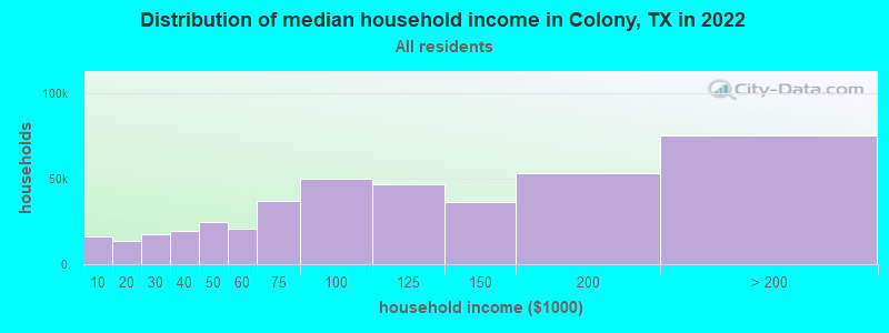
| Colony: | $116,138 |
| TX: | $72,284 |
Estimated per capita income in 2022: $52,874 (it was $27,548 in 2000)
Colony CCD income, earnings, and wages data
Estimated median house or condo value in 2022: $341,033 (it was $101,100 in 2000)
| Colony: | $341,033 |
| TX: | $275,400 |
Mean prices in 2022: all housing units: $486,765; detached houses: $505,331; townhouses or other attached units: $373,634; in 2-unit structures: $286,734; in 3-to-4-unit structures: $285,131; in 5-or-more-unit structures: $357,993; mobile homes: $99,413; occupied boats, rvs, vans, etc.: $214,933
Detailed information about poverty and poor residents in Colony, TX


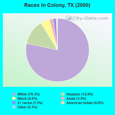
- 24,83678.3%White alone
- 4,10012.9%Hispanic
- 1,4524.6%Black alone
- 5921.9%Asian alone
- 4801.5%Two or more races
- 1970.6%American Indian alone
- 320.1%Other race alone
- 110.03%Native Hawaiian and Other
Pacific Islander alone
Races in Colony detailed stats: ancestries, foreign born residents, place of birth
 Recent articles from our blog. Our writers, many of them Ph.D. graduates or candidates, create easy-to-read articles on a wide variety of topics.

Current Local Time: CST time zone
Land area: 36.6 square miles.
Population density: 1,213 people per square mile (low).

| Colony CCD: | 2.3% ($2,287) |
| Texas: | 1.8% ($1,393) |
Nearest city with pop. 50,000+: Carrollton, TX  (7.7 miles , pop. 109,576).
Nearest city with pop. 200,000+: Plano, TX (8.9 miles , pop. 222,030).
Nearest city with pop. 1,000,000+: Dallas, TX (21.7 miles , pop. 1,188,580).
Nearest cities:
), )Latitude: 33.10 N, Longitude: 96.89 W

| Here: | 3.1% |
| Texas: | 3.5% |
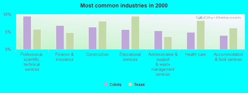
- Professional, scientific, technical services (9.5%)
- Finance & insurance (6.8%)
- Construction (6.4%)
- Educational services (5.7%)
- Administrative & support & waste management services (5.3%)
- Health care (4.9%)
- Accommodation & food services (4.0%)
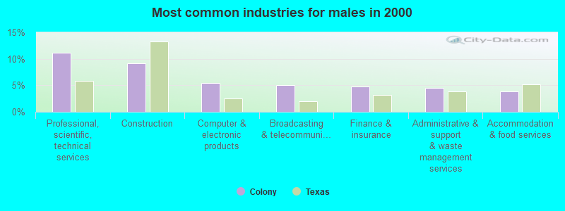
- Professional, scientific, technical services (11.1%)
- Construction (9.1%)
- Computer & electronic products (5.4%)
- Broadcasting & telecommunications (5.1%)
- Finance & insurance (4.7%)
- Administrative & support & waste management services (4.5%)
- Accommodation & food services (3.9%)
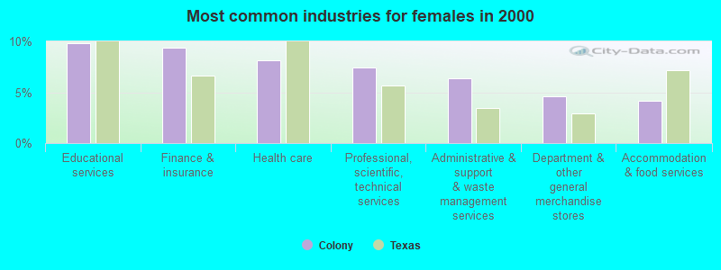
- Educational services (9.8%)
- Finance & insurance (9.4%)
- Health care (8.1%)
- Professional, scientific, technical services (7.5%)
- Administrative & support & waste management services (6.3%)
- Department & other general merchandise stores (4.6%)
- Accommodation & food services (4.2%)
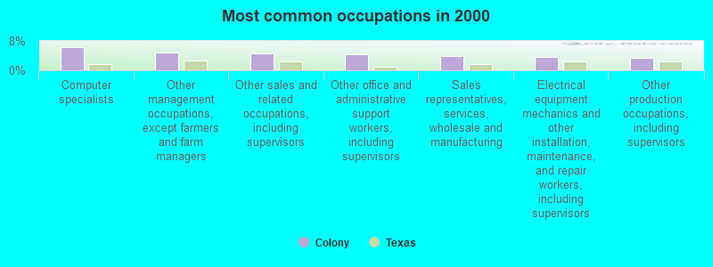
- Computer specialists (6.3%)
- Other management occupations, except farmers and farm managers (4.9%)
- Other sales and related occupations, including supervisors (4.5%)
- Other office and administrative support workers, including supervisors (4.4%)
- Sales representatives, services, wholesale and manufacturing (3.9%)
- Electrical equipment mechanics and other installation, maintenance, and repair workers, including supervisors (3.7%)
- Other production occupations, including supervisors (3.3%)
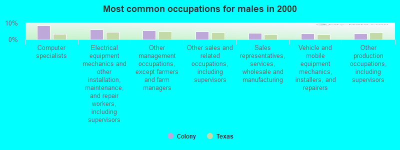
- Computer specialists (8.5%)
- Electrical equipment mechanics and other installation, maintenance, and repair workers, including supervisors (6.1%)
- Other management occupations, except farmers and farm managers (5.6%)
- Other sales and related occupations, including supervisors (5.0%)
- Sales representatives, services, wholesale and manufacturing (4.0%)
- Vehicle and mobile equipment mechanics, installers, and repairers (3.7%)
- Other production occupations, including supervisors (3.6%)
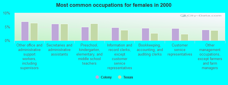
- Other office and administrative support workers, including supervisors (6.9%)
- Secretaries and administrative assistants (6.1%)
- Preschool, kindergarten, elementary, and middle school teachers (4.9%)
- Information and record clerks, except customer service representatives (4.7%)
- Bookkeeping, accounting, and auditing clerks (4.5%)
- Customer service representatives (4.5%)
- Other management occupations, except farmers and farm managers (3.9%)
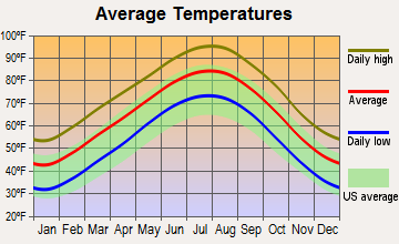
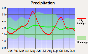
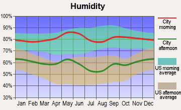
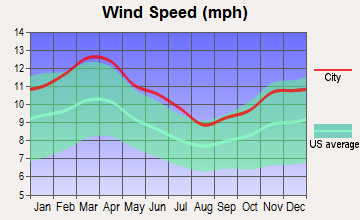
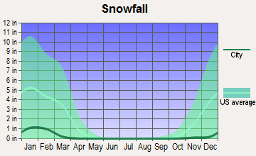
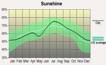
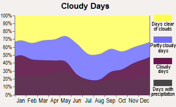
Average climate in Colony, Texas
Based on data reported by over 4,000 weather stations
(lower is better)
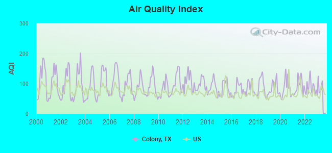
Air Quality Index (AQI) level in 2022 was 87.0. This is about average.
| City: | 87.0 |
| U.S.: | 72.6 |
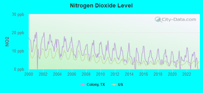
Nitrogen Dioxide (NO2) [ppb] level in 2022 was 6.77. This is worse than average. Closest monitor was 13.4 miles away from the city center.
| City: | 6.77 |
| U.S.: | 5.11 |
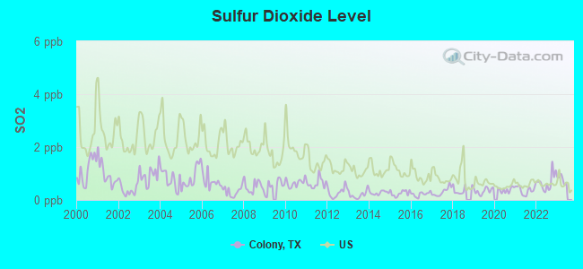
Sulfur Dioxide (SO2) [ppb] level in 2022 was 0.679. This is significantly better than average. Closest monitor was 13.4 miles away from the city center.
| City: | 0.679 |
| U.S.: | 1.515 |
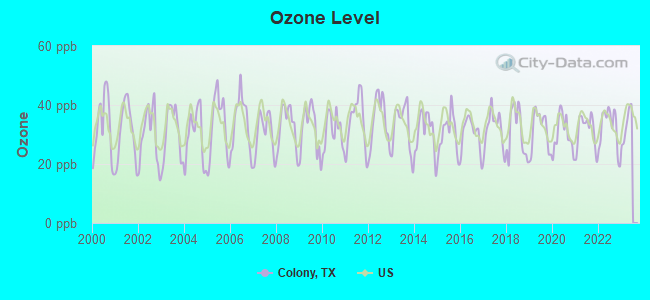
Ozone [ppb] level in 2022 was 32.2. This is about average. Closest monitor was 6.2 miles away from the city center.
| City: | 32.2 |
| U.S.: | 33.3 |
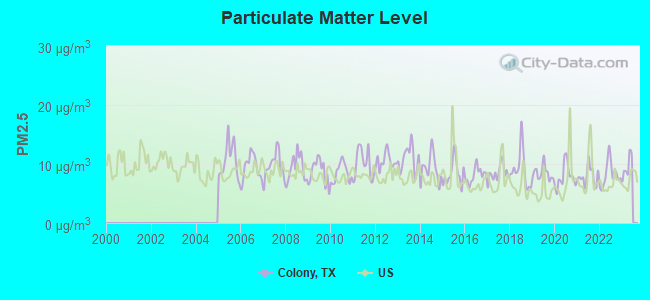
Particulate Matter (PM2.5) [µg/m3] level in 2022 was 8.28. This is about average. Closest monitor was 6.2 miles away from the city center.
| City: | 8.28 |
| U.S.: | 8.11 |
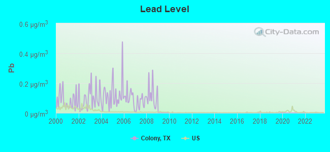
Lead (Pb) [µg/m3] level in 2008 was 0.121. This is significantly worse than average. Closest monitor was 4.2 miles away from the city center.
| City: | 0.121 |
| U.S.: | 0.009 |
Tornado activity:
Colony-area historical tornado activity is above Texas state average. It is 153% greater than the overall U.S. average.
On 4/2/1957, a category F3 (max. wind speeds 158-206 mph) tornado 3.3 miles away from the Colony place center killed 10 people and injured 200 people and caused between $500,000 and $5,000,000 in damages.
On 4/25/1994, a category F4 (max. wind speeds 207-260 mph) tornado 32.4 miles away from the place center killed 3 people and injured 48 people and caused between $50,000,000 and $500,000,000 in damages.
Earthquake activity:
Colony-area historical earthquake activity is significantly above Texas state average. It is 505% greater than the overall U.S. average.On 11/6/2011 at 03:53:10, a magnitude 5.7 (5.7 MW, Depth: 3.2 mi, Class: Moderate, Intensity: VI - VII) earthquake occurred 168.2 miles away from the city center
On 9/3/2016 at 12:02:44, a magnitude 5.8 (5.8 MW, Depth: 3.5 mi) earthquake occurred 229.9 miles away from Colony center
On 6/16/1978 at 11:46:54, a magnitude 5.3 (4.4 MB, 4.6 UK, 5.3 ML) earthquake occurred 224.9 miles away from the city center
On 11/7/2016 at 01:44:24, a magnitude 5.0 (5.0 MW, Depth: 2.8 mi) earthquake occurred 199.9 miles away from the city center
On 5/17/2012 at 08:12:00, a magnitude 4.8 (4.8 MW, Depth: 3.1 mi, Class: Light, Intensity: IV - V) earthquake occurred 167.9 miles away from Colony center
On 11/8/2011 at 02:46:57, a magnitude 4.8 (4.8 MW, Depth: 3.1 mi) earthquake occurred 168.1 miles away from the city center
Magnitude types: body-wave magnitude (MB), local magnitude (ML), moment magnitude (MW)
Natural disasters:
The number of natural disasters in Denton County (18) is near the US average (15).Major Disasters (Presidential) Declared: 7
Emergencies Declared: 9
Causes of natural disasters: Storms: 6, Fires: 5, Floods: 5, Hurricanes: 5, Tornadoes: 5, Wind: 1, Other: 2 (Note: some incidents may be assigned to more than one category).
Hospitals and medical centers near Colony:
- V CARE HOME HEALTH INC (Home Health Center, about 2 miles away; THE COLONY, TX)
- ALLIANCE HOMEHEALTH CARE (Home Health Center, about 2 miles away; THE COLONY, TX)
- SERENITY SERVICES HOME HEALTHCARE LLC (Home Health Center, about 3 miles away; PLANO, TX)
- BAYLOR MEDICAL CENTER AT FRISCO Acute Care Hospitals (about 3 miles away; FRISCO, TX)
- REGENCY HOSPITAL OF NORTH DALLAS II LLLP (Hospital, about 5 miles away; CARROLLTON, TX)
- SKYLIGHT HOME HEALTH CARE INC (Home Health Center, about 5 miles away; CARROLLTON, TX)
- PRAIRIE ESTATES (Nursing Home, about 5 miles away; FRISCO, TX)
Colleges/universities with over 2000 students nearest to Colony:
- The University of Texas at Dallas (about 12 miles; Richardson, TX; Full-time enrollment: 16,777)
- Brookhaven College (about 13 miles; Farmers Branch, TX; FT enrollment: 6,868)
- DeVry University-Texas (about 14 miles; Irving, TX; FT enrollment: 4,098)
- Collin County Community College District (about 15 miles; McKinney, TX; FT enrollment: 18,044)
- Richland College (about 16 miles; Dallas, TX; FT enrollment: 11,617)
- Texas Woman's University (about 17 miles; Denton, TX; FT enrollment: 11,837)
- North Lake College (about 17 miles; Irving, TX; FT enrollment: 6,191)
Points of interest:
Notable locations in Colony: City of Hackberry Wastewater Treatment Plant (A), Pilot Point Waste Water Treatment Plant (B), Stewart Creek Waste Water Treatment Plant (C), Stewart Creek West Water Treament Facility (D), Lewisville Hatchery (E), The Colony Fire Department Central Station (F), Frisco Fire Department Station 4 (G), The Colony Fire Department Station 2 (H), CareFlight - Cotton Gin Road (I). Display/hide their locations on the map
Churches in Colony include: Colony Park Baptist Church (A), Calvary Temple Assembly of God Church (B), African Methodist Episcopal Cornerstone Church (C), First Baptist Church of the Colony (D), Good Shepherd Lutheran Church (E), Saint Peters by the Lake Episcopal Church (F), The Colony Church of Christ (G), Lakeway Baptist Church (H), Trinity Presbyterian Church (I). Display/hide their locations on the map
Cemeteries: Bridges Cemetery (1), Ritter Cemetery (2), Little Elm Cemetery (3). Display/hide their locations on the map
Reservoirs: Phillips Lake (A), Phillips North Lake (B). Display/hide their locations on the map
Creek: Office Creek (A). Display/hide its location on the map
Parks in Colony include: Lake Lewisville Recreation Area (1), Wynnwood Park (2), Stewart Creek Park (3), Eastvale Park (4), East Hill Park (5), Hackberry Park (6), Tommy Briggs Cougar Stadium (7), Griffin Middle School Football Field (8). Display/hide their locations on the map
| This place: | 3.0 people |
| Texas: | 2.7 people |
| This place: | 69.6% |
| Whole state: | 71.5% |
| This place: | 4.3% |
| Whole state: | 4.4% |
Likely homosexual households (counted as self-reported same-sex unmarried-partner households)
- Lesbian couples: 0.3% of all households
- Gay men: 0.1% of all households
| This place: | 3.0% |
| Whole state: | 15.4% |
| This place: | 1.4% |
| Whole state: | 6.7% |
For population 15 years and over in Colony:
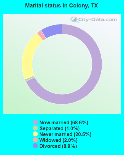
- Never married: 20.5%
- Now married: 68.6%
- Separated: 1.0%
- Widowed: 2.0%
- Divorced: 8.9%
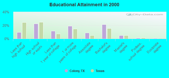
For population 25 years and over in Colony:
- High school or higher: 90.4%
- Bachelor's degree or higher: 28.3%
- Graduate or professional degree: 7.0%
- Unemployed: 3.0%
- Mean travel time to work (commute): 31.1 minutes
| Here: | 9.4 |
| Texas average: | 15.6 |
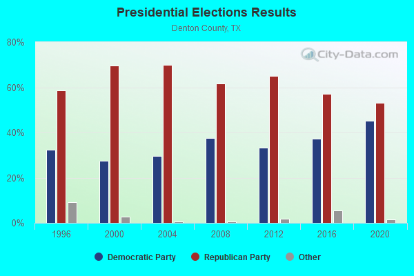
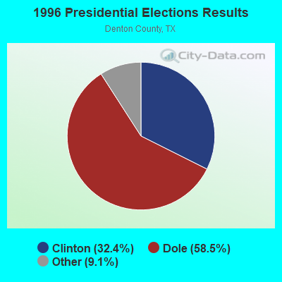

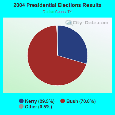

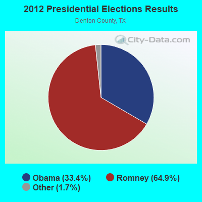
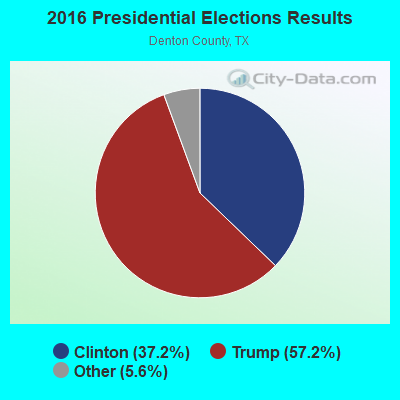
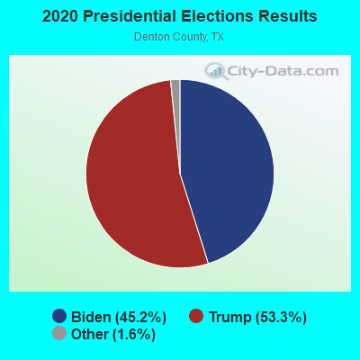
Graphs represent county-level data. Detailed 2008 Election Results
Religion statistics for Colony, TX (based on Denton County data)
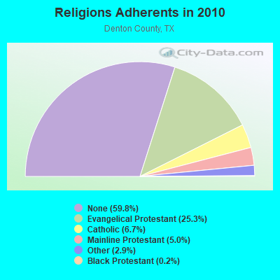
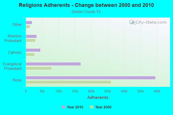
| Religion | Adherents | Congregations |
|---|---|---|
| Evangelical Protestant | 167,945 | 321 |
| Catholic | 44,615 | 8 |
| Mainline Protestant | 33,340 | 56 |
| Other | 18,928 | 42 |
| Black Protestant | 1,354 | 8 |
| Orthodox | 120 | 1 |
| None | 396,312 | - |
Food Environment Statistics:
| Denton County: | 0.85 / 10,000 pop. |
| Texas: | 1.47 / 10,000 pop. |
| Denton County: | 0.16 / 10,000 pop. |
| Texas: | 0.14 / 10,000 pop. |
| This county: | 0.57 / 10,000 pop. |
| Texas: | 1.11 / 10,000 pop. |
| Denton County: | 2.67 / 10,000 pop. |
| State: | 3.95 / 10,000 pop. |
| Denton County: | 4.90 / 10,000 pop. |
| Texas: | 6.13 / 10,000 pop. |
| Here: | 8.5% |
| State: | 8.9% |
| Here: | 28.4% |
| Texas: | 26.6% |
| Here: | 13.8% |
| Texas: | 15.7% |
12.39% of this county's 2021 resident taxpayers lived in other counties in 2020 ($93,158 average adjusted gross income)
| Here: | 12.39% |
| Texas average: | 8.12% |
0.01% of residents moved from foreign countries ($94 average AGI)
Denton County: 0.01% Texas average: 0.04%
Top counties from which taxpayers relocated into this county between 2020 and 2021:
| from Dallas County, TX | |
| from Collin County, TX | |
| from Tarrant County, TX |
10.07% of this county's 2020 resident taxpayers moved to other counties in 2021 ($79,464 average adjusted gross income)
| Here: | 10.07% |
| Texas average: | 7.40% |
0.01% of residents moved to foreign countries ($63 average AGI)
Denton County: 0.01% Texas average: 0.03%
Top counties to which taxpayers relocated from this county between 2020 and 2021:
| to Collin County, TX | |
| to Dallas County, TX | |
| to Tarrant County, TX |
Strongest AM radio stations in Colony:
- KRLD (1080 AM; 50 kW; DALLAS, TX; Owner: TEXAS INFINITY BROADCASTING L.P.)
- KBIS (1150 AM; 25 kW; HIGHLAND PARK, TX; Owner: DALLAS AM RADIO PARTNERS, L.P.)
- KZMP (1540 AM; 50 kW; UNIVERSITY PARK, TX; Owner: ENTRAVISION HOLDINGS, LLC)
- KTCK (1310 AM; 9 kW; DALLAS, TX; Owner: KRBE LICO, INC.)
- KLIF (570 AM; 5 kW; DALLAS, TX; Owner: KLIF LICO, INC.)
- KTNO (1440 AM; 12 kW; DENTON, TX; Owner: MORTENSON BROADCASTING COMPANY)
- KFXR (1190 AM; 50 kW; DALLAS, TX; Owner: CLEAR CHANNEL BROADCASTING LICENSES, INC.)
- WBAP (820 AM; 50 kW; FORT WORTH, TX; Owner: WBAP-KSCS OPERATING, LTD.)
- KESS (1270 AM; 50 kW; FORT WORTH, TX; Owner: KESS-AM LICENSE CORP.)
- KSKY (660 AM; 20 kW; BALCH SPRINGS, TX; Owner: BISON MEDIA, INC.)
- KAAM (770 AM; 10 kW; GARLAND, TX; Owner: DONTRON, INC.)
- KAHZ (1360 AM; 50 kW; HURST, TX)
- KXEB (910 AM; 1 kW; SHERMAN, TX; Owner: AMIGO RADIO, LTD.)
Strongest FM radio stations in Colony:
- KPLX (99.5 FM; FORT WORTH, TX; Owner: KPLX LICO, INC.)
- KLUV-FM (98.7 FM; DALLAS, TX; Owner: INFINITY BROADCASTING CORPORATION OF DALLAS)
- WRR (101.1 FM; DALLAS, TX; Owner: CITY OF DALLAS, TEXAS)
- KESN (103.3 FM; ALLEN, TX; Owner: WBAP-KSCS OPERATING, LTD.)
- KSOC (94.5 FM; GAINESVILLE, TX; Owner: RADIO ONE LICENSES, LLC)
- KTPW (89.7 FM; SANGER, TX; Owner: RESEARCH EDUCATIONAL FOUNDATION, INC)
- KLLI (105.3 FM; DALLAS, TX; Owner: INFINITY BROADCASTING CORPORATION OF DALLAS)
- KNOR (93.7 FM; HEALDTON, OK; Owner: AM & PM BROADCASTERS, LLC)
- KZPS (92.5 FM; DALLAS, TX; Owner: AMFM TEXAS LICENSES LIMITED PARTNERSHIP)
- KHKS (106.1 FM; DENTON, TX; Owner: AMFM TEXAS LICENSES LIMITED PARTNERSHIP)
- KMEO (96.7 FM; FLOWER MOUND, TX; Owner: ABC, INC.)
- KKDL (106.7 FM; MUENSTER, TX; Owner: ENTRAVISION HOLDINGS, LLC)
- KZMP-FM (101.7 FM; AZLE, TX; Owner: ENTRAVISION HOLDINGS, LLC)
- KVIL-FM (103.7 FM; HIGHLAND PARK-DALLAS, TX; Owner: INFINITY BROADCASTING CORPORATION OF TEXAS)
- KKDA-FM (104.5 FM; DALLAS, TX; Owner: SERVICE BROADCASTING I, LTD.)
- KOAI (107.5 FM; FORT WORTH, TX; Owner: INFINITY KOAI-FM, INC.)
- KEGL (97.1 FM; FORT WORTH, TX; Owner: CITICASTERS LICENSES, L.P.)
- KRBV (100.3 FM; DALLAS, TX; Owner: INFINITY BROADCASTING CORP. OF FORT WORTH)
- KBFB (97.9 FM; DALLAS, TX; Owner: RADIO ONE LICENSES, LLC)
- KSCS (96.3 FM; FORT WORTH, TX; Owner: WBAP-KSCS OPERATING, LTD.)
TV broadcast stations around Colony:
- KLDT (Channel 55; LAKE DALLAS, TX; Owner: JOHNSON BROADCASTING OF DALLAS, INC.)
- KLEG-LP (Channel 44; DALLAS, TX; Owner: DILIP VISWANATH)
- KTVT (Channel 11; FORT WORTH, TX; Owner: CBS STATIONS GROUP OF TEXAS L.P.)
- KXAS-TV (Channel 5; FORT WORTH, TX; Owner: STATION VENTURE OPERATIONS, LP)
- KDTN (Channel 2; DENTON, TX; Owner: NORTH TEXAS PUBLIC BROADCASTING, INC.)
- KSTR-TV (Channel 49; IRVING, TX; Owner: TELEFUTURA DALLAS LLC)
- KTXA (Channel 21; FORT WORTH, TX; Owner: VIACOM TELEVISION STATIONS GROUP OF DALLAS/FORT WORTH L.P.)
- KMPX (Channel 29; DECATUR, TX; Owner: WORD OF GOD FELLOWSHIP, INC.)
- KUVN (Channel 23; GARLAND, TX; Owner: KUVN LICENSE PARTNERSHIP, L.P.)
- KPXD (Channel 68; ARLINGTON, TX; Owner: PAXSON DALLAS LICENSE, INC.)
- WFAA-TV (Channel 8; DALLAS, TX; Owner: WFAA-TV, L.P.)
- KERA-TV (Channel 13; DALLAS, TX; Owner: NORTH TEXAS PUBLIC BROADCASTING, INC.)
- KXTX-TV (Channel 39; DALLAS, TX; Owner: TELEMUNDO OF TEXAS PARTNERSHIP, LP)
- KDTX-TV (Channel 58; DALLAS, TX; Owner: TRINITY BROADCASTING OF TEXAS, INC.)
- KDFW (Channel 4; DALLAS, TX; Owner: KDFW LICENSE, INC.)
- KDAF (Channel 33; DALLAS, TX; Owner: TRIBUNE TELEVISION COMPANY)
- KDFI (Channel 27; DALLAS, TX; Owner: NEW DMIC, INC.)
- KJJM-LP (Channel 46; DALLAS/MESQUITE, TX; Owner: JANE McGINNIS)
- KTAQ (Channel 47; GREENVILLE, TX; Owner: MIKE SIMONS)
- K26HF (Channel 26; BRITTON, TX; Owner: MAKO COMMUNICATIONS, LLC)
- KHPK-LP (Channel 28; DE SOTO, TX; Owner: MAKO COMMUNICATIONS, LLC)
- KFWD (Channel 52; FORT WORTH, TX; Owner: HIC BROADCAST, INC.)
- K25FW (Channel 25; CORSICANA, TX; Owner: VENTANA TELEVISION, INC.)
- KATA-LP (Channel 60; MESQUITE, TX; Owner: JANE McGINNIS)
- KVFW-LP (Channel 65; FORT WORTH, TX; Owner: GERALD BENAVIDES)
FCC Registered Antenna Towers:
4- KELLYE E ABERNATHY, 3.1m/50 Dtn From Denton County Line & Hwy 720 (Lat: 33.129444 Lon: -96.872222), Type: 30.4, Overall height: 30.4 m, Registrant: Cingular Wireless LLC, Kellye.E.Abernathy@cingular.Com, , Plano, Phone: (469) 229-7422
- David C Jatlow, 3.1m/50 Dtn From Denton County Line & Hwy 720 (Lat: 33.129444 Lon: -96.872222), Type: 30.4, Overall height: 30.4 m, Registrant: New Cingular Wireless Services, Inc., Esther.Hilliard@attws.Com, , Washi-ngton, Phone: (202) 223-9222
- DAVID C JATLOW, 3.1m/50 Dtn From Denton County Line & Hwy 720 (Lat: 33.129444 Lon: -96.872222), Type: 30.4, Overall height: 30.4 m, Registrant: Cingular Wireless LLC, Kellye.E.Abernathy, , Dalla-s, Phone: (972) 733-2092
- 3.1m/50 Dtn From Denton County Line & Hwy 720 (Lat: 33.129444 Lon: -96.872222), Type: 30.4, Overall height: 30.4 m, Registrant: At&t Wireless Services, Inc., Esther.Hilliard@attws.Com, , Washi-ngton, Phone: (202) 223-9222
FCC Registered Broadcast Land Mobile Towers:
1- GRANDSCAPE, Lat: 33.068778 Lon: -96.865083, Call Sign: WQYV870, Licensee ID: L01502812,
Assigned Frequencies: 451.187 MHz, Grant Date: 02/07/2017, Expiration Date: 02/07/2027, Certifier: Jack Graudenz, Registrant: Cereniti Datasense Networks, 8765 Guion Rd., Suite D, Indianapolis, IN 46268, Phone: (877) 237-3648, Fax: (877) 362-6640, Email:
FCC Registered Microwave Towers:
4- COLONY, 5313 S Colony Blvd (Lat: 33.084833 Lon: -96.874722), Overall height: 30.8 m, Call Sign: WMR717, Licensee ID: L00001129,
Assigned Frequencies: 10553.7 MHz, Grant Date: 03/06/2001, Expiration Date: 02/01/2011, Cancellation Date: 12/13/2001, Registrant: Dallas Smsa Limited Partnership, 17330 Preston Rd Ste 100a, Dallas, TX 75252
- DLS0106, 724 Holfords Prairie Rd. (Lat: 33.037778 Lon: -96.936389), Type: Pole, Structure height: 31.1 m, Call Sign: WPXH434,
Assigned Frequencies: 19380.0 MHz, 19440.0 MHz, Grant Date: 04/04/2003, Expiration Date: 04/04/2013, Cancellation Date: 06/08/2013, Certifier: Joseph M Sandri Jr., Registrant: Willkie Farr & Gallagher LLP, 1875 K Street Nw, Washington, DC 20006, Phone: (202) 303-1111, Fax: (202) 303-2111, Email:
- DLS0104, 7200 Griffin Road (Lat: 33.083889 Lon: -96.854167), Type: Pole, Structure height: 22.8 m, Call Sign: WPXH438,
Assigned Frequencies: 19380.0 MHz, 19620.0 MHz, Grant Date: 04/04/2003, Expiration Date: 04/04/2013, Cancellation Date: 06/08/2013, Certifier: Joseph M Sandri Jr., Registrant: Willkie Farr & Gallagher LLP, 1875 K Street Nw, Washington, DC 20006, Phone: (202) 303-1111, Fax: (202) 303-2111, Email:
- DLS0119, 3.1m/50 Dtn From Denton County Line & Hwy 720 (Lat: 33.129444 Lon: -96.872222), Type: Pole, Structure height: 30.4 m, Call Sign: WPYG330,
Assigned Frequencies: 10597.5 MHz, 18000.0 MHz, Grant Date: 08/06/2003, Expiration Date: 08/06/2013, Cancellation Date: 01/23/2006, Certifier: Eric Botto, Registrant: Comsearch, 19700 Janelia Farm Boulevard, Ashburn, VA 20147, Phone: (703) 726-5671, Fax: (703) 726-5594, Email:
FCC Registered Amateur Radio Licenses:
3- Call Sign: WA5ZKK, Licensee ID: L01093332, Grant Date: 12/13/2016, Expiration Date: 12/13/2026, Registrant: Martin A Multer, 5244 Bartlett Dr, Colony, TX 75056
- Call Sign: WD0HCO, Licensee ID: L00419322, Grant Date: 10/07/2002, Expiration Date: 01/05/2013, Cancellation Date: 02/12/2011, Certifier: Bismarck C Wichy, Registrant: Bismarck C Wichy, 4209 Lakeside Dr, Colony, TX 75056
- Call Sign: K5BIZ, Previous Call Sign: WD0HCO, Licensee ID: L00419322, Grant Date: 02/12/2011, Expiration Date: 02/12/2021, Cancellation Date: 02/14/2023, Certifier: Bismarck C Wichy, Registrant: Bismarck C Wichy, 4209 Lakeside Dr, Colony, TX 75056
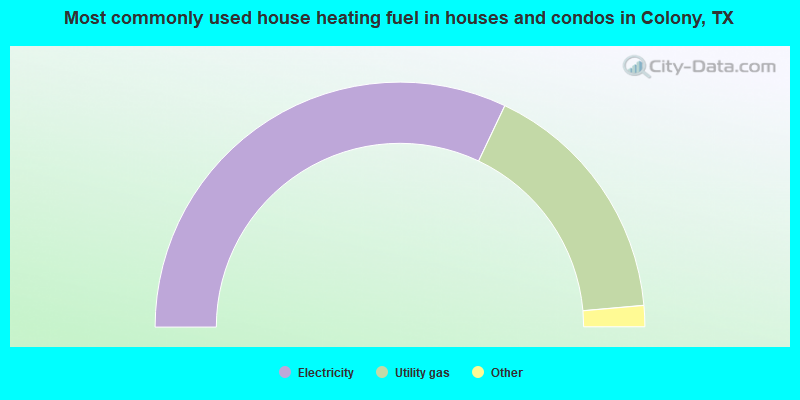
- 64.1%Electricity
- 33.1%Utility gas
- 2.6%Bottled, tank, or LP gas
- 0.2%No fuel used
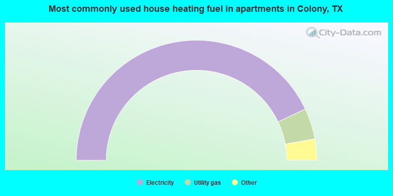
- 86.0%Electricity
- 8.3%Utility gas
- 2.7%Bottled, tank, or LP gas
- 2.3%No fuel used
- 0.7%Other fuel
Colony compared to Texas state average:
- Median household income above state average.
- Unemployed percentage significantly below state average.
- Black race population percentage below state average.
- Hispanic race population percentage significantly below state average.
- Foreign-born population percentage significantly below state average.
- Renting percentage significantly below state average.
- Length of stay since moving in significantly above state average.
- Number of rooms per house significantly below state average.
- House age significantly below state average.
Colony on our top lists:
- #13 on the list of "Top 101 cities with largest percentage of males in industries: broadcasting and telecommunications (population 5,000+)"
- #37 on the list of "Top 101 cities with largest percentage of males in occupations: computer specialists (population 5,000+)"
- #37 on the list of "Top 101 cities with largest percentage of females in occupations: judges, magistrates, and other judicial workers (population 5,000+)"
- #45 on the list of "Top 101 cities with largest percentage of females in industries: vending machine operators (population 5,000+)"
- #50 on the list of "Top 101 cities with largest percentage of males in industries: radio, tv, and computer stores (population 5,000+)"
- #54 on the list of "Top 101 cities with largest percentage of females in industries: radio, tv, and computer stores (population 5,000+)"
- #58 on the list of "Top 101 cities with largest percentage of females in occupations: customer service representatives (population 5,000+)"
- #59 on the list of "Top 101 cities with largest percentage of females in occupations: construction laborers (population 5,000+)"
- #67 on the list of "Top 101 cities with largest percentage of females in occupations: computer specialists (population 5,000+)"
- #68 on the list of "Top 101 cities with largest percentage of females in occupations: sales representatives, services, wholesale and manufacturing (population 5,000+)"
- #69 on the list of "Top 101 cities with largest percentage of females in industries: professional and commercial equipment and supplies merchant wholesalers (population 5,000+)"
- #70 on the list of "Top 101 cities with largest percentage of females in industries: groceries and related products merchant wholesalers (population 5,000+)"
- #87 on the list of "Top 101 cities with largest percentage of females in industries: broadcasting and telecommunications (population 5,000+)"
- #90 on the list of "Top 101 cities with largest percentage of females in industries: warehousing and storage (population 5,000+)"
- #97 on the list of "Top 101 cities with largest percentage of females in industries: metals and minerals, except petroleum, merchant wholesalers (population 5,000+)"
- #9 on the list of "Top 101 counties with the lowest number of deaths per 1000 residents 2007-2013 (pop. 50,000+)"
- #11 on the list of "Top 101 counties with the highest surface withdrawal of fresh water for public supply"
- #15 on the list of "Top 101 counties with the highest total withdrawal of fresh water for public supply"
- #19 on the list of "Top 101 counties with the largest number of children under 18 without health insurance coverage in 2000 (pop. 50,000+)"
- #33 on the list of "Top 101 counties with the most Evangelical Protestant adherents"

|
Total of 1 patent application in 2008-2024.