Delta, California
Submit your own pictures of this place and show them to the world
- OSM Map
- General Map
- Google Map
- MSN Map

| Males: 2,855 | |
| Females: 2,538 |
| Median resident age: | 41.4 years |
| California median age: | 33.3 years |
Zip code: 95690
| Delta: | $73,273 |
| CA: | $91,551 |
Estimated per capita income in 2022: $39,431 (it was $20,444 in 2000)
Delta CCD income, earnings, and wages data
Estimated median house or condo value in 2022: $480,316 (it was $126,300 in 2000)
| Delta: | $480,316 |
| CA: | $715,900 |
Mean prices in 2022: all housing units: $563,621; detached houses: $591,153; townhouses or other attached units: $482,279; in 2-unit structures: $602,252; in 3-to-4-unit structures: $385,294; in 5-or-more-unit structures: $351,681; mobile homes: $121,197; occupied boats, rvs, vans, etc.: $329,901
Detailed information about poverty and poor residents in Delta, CA


- 2,61754.2%White alone
- 1,62233.6%Hispanic
- 3417.1%Asian alone
- 1453.0%Two or more races
- 420.9%Black alone
- 340.7%American Indian alone
- 200.4%Other race alone
- 90.2%Native Hawaiian and Other
Pacific Islander alone

 Recent articles from our blog. Our writers, many of them Ph.D. graduates or candidates, create easy-to-read articles on a wide variety of topics.

Current Local Time: PST time zone
Land area: 110.6 square miles.
Population density: 49 people per square mile (very low).

| Delta CCD: | 0.7% ($936) |
| California: | 0.8% ($1,564) |
Nearest city with pop. 50,000+: Lodi, CA  (16.8 miles , pop. 56,999).
Nearest city with pop. 200,000+: Stockton, CA (21.3 miles , pop. 243,771).
Nearest city with pop. 1,000,000+: Los Angeles, CA (335.6 miles , pop. 3,694,820).
Nearest cities:
), ), ), )Latitude: 38.19 N, Longitude: 121.58 W
Area code commonly used in this area: 916

| Here: | 4.7% |
| California: | 5.1% |

- Agriculture, forestry, fishing & hunting (17.3%)
- Construction (10.0%)
- Accommodation & food services (7.7%)
- Educational services (6.2%)
- Public administration (6.2%)
- Repair & maintenance (5.0%)
- Health care (4.1%)

- Agriculture, forestry, fishing & hunting (22.2%)
- Construction (14.7%)
- Repair & maintenance (6.8%)
- Accommodation & food services (5.3%)
- Public administration (5.3%)
- Metal & metal products (3.3%)
- Educational services (3.3%)

- Accommodation & food services (11.1%)
- Educational services (10.4%)
- Agriculture, forestry, fishing & hunting (9.9%)
- Health care (9.0%)
- Public administration (7.5%)
- Finance & insurance (7.2%)
- Arts, entertainment, recreation (5.0%)

- Agricultural workers, including supervisors (10.8%)
- Building and grounds cleaning and maintenance occupations (6.5%)
- Vehicle and mobile equipment mechanics, installers, and repairers (5.5%)
- Information and record clerks, except customer service representatives (4.4%)
- Driver/sales workers and truck drivers (4.0%)
- Other management occupations, except farmers and farm managers (3.7%)
- Other sales and related occupations, including supervisors (3.2%)

- Agricultural workers, including supervisors (13.3%)
- Vehicle and mobile equipment mechanics, installers, and repairers (8.4%)
- Building and grounds cleaning and maintenance occupations (6.3%)
- Driver/sales workers and truck drivers (5.5%)
- Farmers and farm managers (5.0%)
- Carpenters (4.1%)
- Other sales and related occupations, including supervisors (3.7%)

- Information and record clerks, except customer service representatives (9.5%)
- Agricultural workers, including supervisors (7.2%)
- Building and grounds cleaning and maintenance occupations (6.9%)
- Secretaries and administrative assistants (5.7%)
- Other office and administrative support workers, including supervisors (4.9%)
- Cooks and food preparation workers (4.1%)
- Other management occupations, except farmers and farm managers (4.1%)
Average climate in Delta, California
Based on data reported by over 4,000 weather stations


(lower is better)

Air Quality Index (AQI) level in 2023 was 77.3. This is about average.
| City: | 77.3 |
| U.S.: | 72.6 |

Carbon Monoxide (CO) [ppm] level in 2023 was 0.319. This is worse than average. Closest monitor was 7.1 miles away from the city center.
| City: | 0.319 |
| U.S.: | 0.251 |

Nitrogen Dioxide (NO2) [ppb] level in 2023 was 2.80. This is significantly better than average. Closest monitor was 7.1 miles away from the city center.
| City: | 2.80 |
| U.S.: | 5.11 |

Sulfur Dioxide (SO2) [ppb] level in 2023 was 1.32. This is about average. Closest monitor was 13.3 miles away from the city center.
| City: | 1.32 |
| U.S.: | 1.51 |

Ozone [ppb] level in 2023 was 29.0. This is about average. Closest monitor was 7.1 miles away from the city center.
| City: | 29.0 |
| U.S.: | 33.3 |

Particulate Matter (PM10) [µg/m3] level in 2022 was 25.0. This is worse than average. Closest monitor was 13.3 miles away from the city center.
| City: | 25.0 |
| U.S.: | 19.2 |

Particulate Matter (PM2.5) [µg/m3] level in 2022 was 10.3. This is worse than average. Closest monitor was 22.8 miles away from the city center.
| City: | 10.3 |
| U.S.: | 8.1 |

Lead (Pb) [µg/m3] level in 2023 was 0.00414. This is significantly better than average. Closest monitor was 13.3 miles away from the city center.
| City: | 0.00414 |
| U.S.: | 0.00931 |
Earthquake activity:
Delta-area historical earthquake activity is significantly above California state average. It is 7830% greater than the overall U.S. average.On 4/18/1906 at 13:12:21, a magnitude 7.9 (7.9 UK, Class: Major, Intensity: VIII - XII) earthquake occurred 78.5 miles away from the city center, causing $524,000,000 total damage
On 10/18/1989 at 00:04:15, a magnitude 7.1 (6.5 MB, 7.1 MS, 6.9 MW, 7.0 ML) earthquake occurred 75.6 miles away from the city center, causing 62 deaths (62 shaking deaths) and 3757 injuries, causing $1,305,032,704 total damage
On 7/21/1952 at 11:52:14, a magnitude 7.7 (7.7 UK) earthquake occurred 263.2 miles away from Delta center, causing $50,000,000 total damage
On 11/4/1927 at 13:51:53, a magnitude 7.5 (7.5 UK) earthquake occurred 228.7 miles away from Delta center
On 10/3/1915 at 06:52:48, a magnitude 7.6 (7.6 UK) earthquake occurred 270.3 miles away from the city center
On 1/31/1922 at 13:17:28, a magnitude 7.6 (7.6 UK) earthquake occurred 274.0 miles away from the city center
Magnitude types: body-wave magnitude (MB), local magnitude (ML), surface-wave magnitude (MS), moment magnitude (MW)
Natural disasters:
The number of natural disasters in Sacramento County (18) is near the US average (15).Major Disasters (Presidential) Declared: 11
Emergencies Declared: 3
Causes of natural disasters: Floods: 13, Winter Storms: 6, Storms: 5, Mudslides: 4, Landslides: 3, Drought: 1, Earthquake: 1, Heavy Rain: 1, Hurricane: 1, Tornado: 1, Wind: 1, Other: 1 (Note: some incidents may be assigned to more than one category).
Hospitals and medical centers near Delta:
- WOODBRIDGE ICF (Hospital, about 15 miles away; WOODBRIDGE, CA)
- GOLDEN LIVING CENTER - GALT (Nursing Home, about 16 miles away; GALT, CA)
- LODI MEMORIAL HOSPITAL - WEST D/P SNF (Nursing Home, about 16 miles away; LODI, CA)
- LODI MEMORIAL HOSPITAL - WEST (Hospital, about 16 miles away; LODI, CA)
- GAPASIN MANOR ICF DDN #3 (Hospital, about 16 miles away; STOCKTON, CA)
Colleges/universities with over 2000 students nearest to Delta:
- San Joaquin Delta College (about 20 miles; Stockton, CA; Full-time enrollment: 12,167)
- Cosumnes River College (about 20 miles; Sacramento, CA; FT enrollment: 9,327)
- Los Medanos College (about 21 miles; Pittsburg, CA; FT enrollment: 5,289)
- University of the Pacific (about 21 miles; Stockton, CA; FT enrollment: 4,999)
- Sacramento City College (about 25 miles; Sacramento, CA; FT enrollment: 15,963)
- University of California-Davis (about 26 miles; Davis, CA; FT enrollment: 30,845)
- California State University-Sacramento (about 27 miles; Sacramento, CA; FT enrollment: 22,234)
Points of interest:
Notable locations in Delta: Delta Meadows Project (A), Gutman Landing (B), Larsen Landing (C), Perley Landing (D), Vormans Landing (E), Wood-Curtis Landing (F), Baldocchi Landing (G), Mathens Landing (H), Landing Number 63 (I), De Back Landing (J), Coggenshall Landing (K), Danady Landing (L), Runyon Landing (M), Talmadge Landing (N), McCollough Landing (O), Morse Landing (P), Wedley Landing (Q), Dean Landing Number B One Hundred Twelve (R), Elliott Landing Number B One Hundred Ten (S), Greens Landing Number B One Hundred Twelve and a Half (T). Display/hide their locations on the map
Lakes and swamps: The Meadows Slough (A), Sherman Lake (B), The Oxbow (C), Donlon Lake (D), Beaver Lake (E). Display/hide their locations on the map
Streams, rivers, and creeks: Cabin Slough (A), Georgiana Slough (B), Sutter Slough (C), Steamboat Slough (D), San Joaquin River (E). Display/hide their locations on the map
Parks in Delta include: Brannan Island State Recreation Area (1), Sherman Island Waterfowl Management Area (2), Brannon Island State Recreational Area (3), Hogback Island Recreation Facility (4), Georgiana Slough Fishing Access (5), Locke Historic District (6), Sandy Beach Park (7), Walnut Grove Chinese-American Historic District (8), Walnut Grove Commercial-Residential Historic District (9). Display/hide their locations on the map
| This place: | 2.5 people |
| California: | 2.9 people |
| This place: | 39.7% |
| Whole state: | 69.4% |
| This place: | 5.9% |
| Whole state: | 5.9% |
Likely homosexual households (counted as self-reported same-sex unmarried-partner households)
- Lesbian couples: 0.3% of all households
- Gay men: 0.4% of all households
| This place: | 10.7% |
| Whole state: | 14.2% |
| This place: | 3.0% |
| Whole state: | 6.3% |
People in group quarters in Delta in 2000:
- 86 people in agriculture workers' dormitories on farms
- 6 people in college dormitories (includes college quarters off campus)
- 5 people in other noninstitutional group quarters
- 2 people in unknown juvenile institutions
For population 15 years and over in Delta:

- Never married: 21.5%
- Now married: 59.6%
- Separated: 2.9%
- Widowed: 8.1%
- Divorced: 10.9%
For population 25 years and over in Delta:
- High school or higher: 70.8%
- Bachelor's degree or higher: 13.0%
- Graduate or professional degree: 3.7%
- Unemployed: 10.2%
- Mean travel time to work (commute): 26.1 minutes


| Here: | 16.5 |
| California average: | 16.1 |
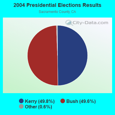
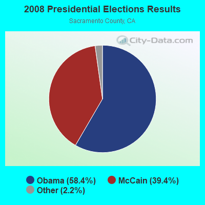
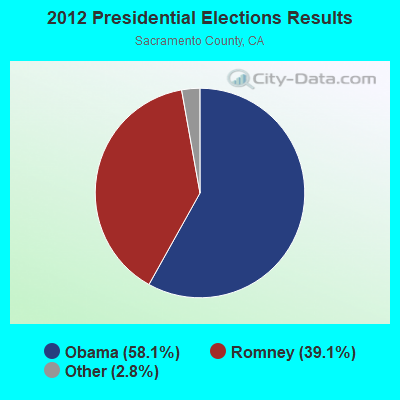
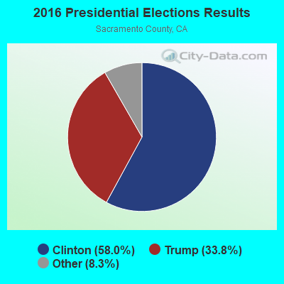
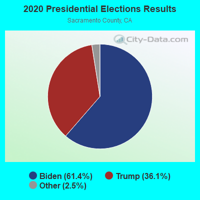
Graphs represent county-level data. Detailed 2008 Election Results
Religion statistics for Delta, CA (based on Sacramento County data)
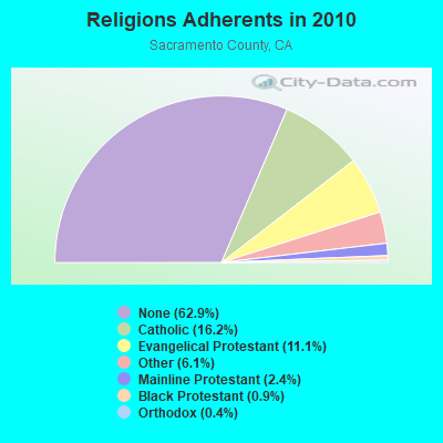
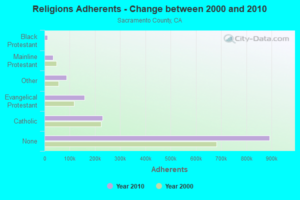
| Religion | Adherents | Congregations |
|---|---|---|
| Catholic | 229,725 | 45 |
| Evangelical Protestant | 157,621 | 493 |
| Other | 86,390 | 183 |
| Mainline Protestant | 33,989 | 105 |
| Black Protestant | 12,585 | 38 |
| Orthodox | 5,675 | 12 |
| None | 892,803 | - |
Food Environment Statistics:
| Sacramento County: | 1.85 / 10,000 pop. |
| California: | 2.14 / 10,000 pop. |
| Sacramento County: | 0.07 / 10,000 pop. |
| State: | 0.04 / 10,000 pop. |
| Sacramento County: | 0.62 / 10,000 pop. |
| State: | 0.62 / 10,000 pop. |
| Sacramento County: | 1.69 / 10,000 pop. |
| California: | 1.49 / 10,000 pop. |
| This county: | 6.68 / 10,000 pop. |
| California: | 7.42 / 10,000 pop. |
| Sacramento County: | 7.8% |
| California: | 7.3% |
| Sacramento County: | 25.0% |
| California: | 21.3% |
| Sacramento County: | 15.4% |
| California: | 17.9% |
5.68% of this county's 2021 resident taxpayers lived in other counties in 2020 ($67,729 average adjusted gross income)
| Here: | 5.68% |
| California average: | 5.19% |
0.01% of residents moved from foreign countries ($150 average AGI)
Sacramento County: 0.01% California average: 0.03%
Top counties from which taxpayers relocated into this county between 2020 and 2021:
| from Placer County, CA | |
| from Alameda County, CA | |
| from Yolo County, CA |
6.10% of this county's 2020 resident taxpayers moved to other counties in 2021 ($74,281 average adjusted gross income)
| Here: | 6.10% |
| California average: | 6.14% |
0.01% of residents moved to foreign countries ($109 average AGI)
Sacramento County: 0.01% California average: 0.02%
Top counties to which taxpayers relocated from this county between 2020 and 2021:
| to Placer County, CA | |
| to Yolo County, CA | |
| to El Dorado County, CA |
Strongest AM radio stations in Delta:
- KHTK (1140 AM; 50 kW; SACRAMENTO, CA; Owner: INFINITY RADIO SUBSIDIARY OPERATIONS INC.)
- KSTE (650 AM; 25 kW; RANCHO CORDOVA, CA; Owner: AMFM RADIO LICENSES, L.L.C.)
- KATD (990 AM; 10 kW; PITTSBURG, CA; Owner: RADIO UNICA OF SACRAMENTO LICENSE CORP.)
- KCBC (770 AM; 50 kW; RIVERBANK, CA; Owner: KIERTRON, INC.)
- KTRB (860 AM; 50 kW; MODESTO, CA; Owner: PAPPAS RADIO OF CALIFORNIA, A CALIFORNIA LIMITED PARTNERSHIP)
- KCBS (740 AM; 50 kW; SAN FRANCISCO, CA; Owner: INFINITY BROADCASTING OPERATIONS, INC.)
- KNBR (680 AM; 50 kW; SAN FRANCISCO, CA; Owner: KNBR LICO, INC.)
- KGO (810 AM; 50 kW; SAN FRANCISCO, CA; Owner: KGO-AM RADIO, INC.)
- KTCT (1050 AM; 50 kW; SAN MATEO, CA; Owner: SUSQUEHANNA RADIO CORP.)
- KFAX (1100 AM; 50 kW; SAN FRANCISCO, CA; Owner: GOLDEN GATE BROADCASTING CO, INC.)
- KFBK (1530 AM; 50 kW; SACRAMENTO, CA; Owner: AMFM RADIO LICENSES, L.L.C.)
- KFIA (710 AM; 25 kW; CARMICHAEL, CA; Owner: VISTA BROADCASTING INC.)
- KIQI (1010 AM; 35 kW; SAN FRANCISCO, CA; Owner: RADIO UNICA OF SAN FRANCISCO LICENSE CORP.)
Strongest FM radio stations in Delta:
- KKSF-FM1 (103.7 FM; PLEASANTON, ETC., CA; Owner: AMFM RADIO LICENSES, L.L.C.)
- KXJZ (88.9 FM; SACRAMENTO, CA; Owner: CALIFORNIA STATE UNIV., SACRAMENTO)
- KBLX-FM2 (102.9 FM; PLEASANTON, CA; Owner: ICBC BROADCAST HOLDINGS -CA, INC.)
- KSOL-FM3 (98.9 FM; PLEASANTON, CA; Owner: TMS LICENSE CALIFORNIA, INC)
- KFRC-FM3 (99.7 FM; WALNUT CREEK, CA; Owner: INFINITY KFRC-FM, INC.)
- KZBR-FM1 (95.7 FM; WALNUT CREEK, CA; Owner: BONNEVILLE HOLDING COMPANY)
- KMEL-FM1 (106.1 FM; CONCORD, CA; Owner: AMFM RADIO LICENSES, L.L.C.)
- KISQ-FM3 (98.1 FM; CONCORD, CA; Owner: AMFM RADIO LICENSES, L.L.C.)
- KJOY (99.3 FM; STOCKTON, CA; Owner: CITADEL BROADCASTING COMPANY)
- KUIC (95.3 FM; VACAVILLE, CA; Owner: KUIC, INC.)
- K238AC (95.5 FM; SALIDA, CA; Owner: FAMILY STATIONS, INC.)
- KOSO (93.1 FM; PATTERSON, CA; Owner: CAPSTAR TX LIMITED PARTNERSHIP)
- KNDL (89.9 FM; ANGWIN, CA; Owner: HOWELL MOUNTAIN BROADCASTING COMPANY)
- KLVR (91.9 FM; SANTA ROSA, CA; Owner: EDUCATIONAL MEDIA FOUNDATION)
- KXTS (100.9 FM; CALISTOGA, CA; Owner: SINCLAIR TELECABLE, INC.)
- KBBF (89.1 FM; SANTA ROSA, CA; Owner: BILINGUAL B/CING. FOUNDATION, INC.)
- KZBR-FM2 (95.7 FM; LIVERMORE, ETC., CA; Owner: BONNEVILLE HOLDING COMPANY)
- KEDR (88.1 FM; SACRAMENTO, CA; Owner: FAMILY STATIONS, INC.)
- KSFB-FM (100.7 FM; SAN RAFAEL, CA; Owner: GOLDEN GATE BROADCASTING COMPANY, INC.)
- KXCL (103.9 FM; YUBA CITY, CA; Owner: HARLAN COMMUNICATIONS, INC.)
TV broadcast stations around Delta:
- KOVR (Channel 13; STOCKTON, CA; Owner: SCI - SACRAMENTO LICENSEE, LLC)
- KXTV (Channel 10; SACRAMENTO, CA; Owner: KXTV, INC.)
- KCRA-TV (Channel 3; SACRAMENTO, CA; Owner: KCRA HEARST-ARGYLE TELEVISION, INC.)
- KSPX (Channel 29; SACRAMENTO, CA; Owner: PAXSON SACRAMENTO LICENSE, INC.)
- KUVS (Channel 19; MODESTO, CA; Owner: KUVS LICENSE PARTNERSHIP, G.P.)
- KTXL (Channel 40; SACRAMENTO, CA; Owner: CHANNEL 40, INC.)
- KVIE (Channel 6; SACRAMENTO, CA; Owner: KVIE, INC.)
- KQCA (Channel 58; STOCKTON, CA; Owner: KCRA HEARST-ARGYLE TELEVISION, INC.)
- KMAX-TV (Channel 31; SACRAMENTO, CA; Owner: UPN STATIONS GROUP INC.)
- KMMK-LP (Channel 14; SACRAMENTO, CA; Owner: CABALLERO TELEVISION TEXAS, L.L.C.)
- KEZT-CA (Channel 23; SACRAMENTO, CA; Owner: TELEFUTURA SACRAMENTO LLC)
- KQED (Channel 9; SAN FRANCISCO, CA; Owner: KQED, INC.)
- KTNC-TV (Channel 42; CONCORD, CA; Owner: KTNC LICENSE, LLC)
- KDTS-CA (Channel 52; STOCKTON, CA; Owner: WORD OF GOD FELLOWSHIP, INC.)
- KRJR-LP (Channel 47; SACRAMENTO, CA; Owner: WORD OF GOD FELLOWSHIP, INC.)
FCC Registered Broadcast Land Mobile Towers:
6- SUGARLOAFMTN, Sugarloaf Mtn 3 Km S (Lat: 40.914583 Lon: -122.444722), Type: Tower, Structure height: 24.4 m, Overall height: 29.6 m, Call Sign: KNFD872,
Assigned Frequencies: 857.737 MHz, 857.737 MHz, Grant Date: 04/03/2015, Expiration Date: 06/15/2025, Certifier: Glen S Nash, Registrant: State Of California, 601 Sequoia Pacific Blvd, Sacramento, CA 95811-0231, Phone: (916) 894-5102, Fax: (916) 894-5392, Email:
- Sugarloaf Mountain 2 Mi S (Lat: 40.914583 Lon: -122.444722), Structure height: 24 m, Call Sign: KJS890,
Assigned Frequencies: 153.755 MHz, 153.755 MHz, Grant Date: 10/06/2015, Expiration Date: 12/18/2025, Registrant: State Of California, 601 Sequoia-Pacific Blvd., Sacramento, CA 95811-0231, Phone: (916) 894-5096, Fax: (916) 894-5392, Email:
- SUGARLOAFMTN, Sugarloaf Mtn 3 Km S (Lat: 40.914583 Lon: -122.444722), Type: Tower, Structure height: 24.4 m, Overall height: 29.6 m, Call Sign: KFA407,
Assigned Frequencies: 42.3400 MHz, 42.4400 MHz, 44.9800 MHz, 45.1400 MHz, Grant Date: 11/08/2023, Expiration Date: 02/02/2034, Registrant: State Of California, 601 Sequoia-Pacific Blvd., Sacramento, CA 95811-0231, Phone: (916) 894-5096, Fax: (916) 894-5392, Email:
- Sugarloaf Mountain 2 Mi S (Lat: 40.914583 Lon: -122.444722), Structure height: 24 m, Call Sign: WNNL796,
Assigned Frequencies: 460.450 MHz, 460.450 MHz, Grant Date: 12/23/2023, Expiration Date: 03/15/2034, Registrant: State Of California, 601 Sequoia-Pacific Blvd., Sacramento, CA 95811-0231, Phone: (916) 894-5096, Fax: (916) 894-5392, Email:
- Sugarloaf Lookout (Lat: 40.914583 Lon: -122.444722), Call Sign: WNNL797,
Assigned Frequencies: 154.680 MHz, 154.680 MHz, Grant Date: 11/04/2023, Expiration Date: 01/26/2034, Registrant: State Of California, 601 Sequoia-Pacific Blvd., Sacramento, CA 95811-0231, Phone: (916) 894-5096, Fax: (916) 894-5392, Email:
- Sugarloaf Mountain 3 Km S (Lat: 40.914583 Lon: -122.444722), Type: Tower, Structure height: 24 m, Call Sign: WPOZ441,
Assigned Frequencies: 47.1000 MHz, Grant Date: 07/02/2014, Expiration Date: 09/13/2024, Certifier: Glen S Nash, Registrant: State Of California, 601 Sequoia-Pacific Blvd., Sacramento, CA 95811-0231, Phone: (916) 894-5096, Fax: (916) 894-5392, Email:
FCC Registered Microwave Towers:
3- SUGARLOAFMTN, Sugarloaf Mtn 3 Km S (Lat: 40.914583 Lon: -122.444722), Type: Ltower, Structure height: 24.4 m, Overall height: 29.6 m, Call Sign: KFW31,
Assigned Frequencies: 6695.00 MHz, 6675.00 MHz, 7037.50 MHz, 7037.50 MHz, 7037.50 MHz, 6937.50 MHz, 6937.50 MHz, 6937.50 MHz, Grant Date: 08/01/2018, Expiration Date: 10/16/2028, Registrant: State Of California, 601 Sequoia Pacific Blvd, Sacramento, CA 95811-0231, Phone: (916) 894-5102, Fax: (916) 894-5392, Email:
- SUGARLOAFMTNDOT, 1. 7 Miles West Of Upper Soda Road (Lat: 40.914583 Lon: -122.444722), Type: Ltower, Structure height: 7.6 m, Call Sign: WRJY327,
Assigned Frequencies: 10755.0 MHz, 6286.19 MHz, Grant Date: 11/18/2020, Expiration Date: 11/18/2030, Certifier: Deneke Mattewos, Registrant: State Of California, 601 Sequoia Pacific Blvd, Sacramento, CA 95811-0231, Phone: (916) 894-5102, Fax: (916) 894-5392, Email:
- SUGARLOAFMT, 4 Miles Ssw Of (Lat: 40.907639 Lon: -122.445000), Overall height: 20.7 m, Call Sign: WHO208,
Assigned Frequencies: 4198.00 MHz, 4198.00 MHz, Grant Date: 09/15/1994, Expiration Date: 02/01/2000, Cancellation Date: 01/26/1998, Registrant: At&t Communications Of California Inc, 1200 Peachtree St 15w27, Atlanta, GA 30309
FCC Registered Paging Towers:
3- Sugarloaf Lookout, 2.3 Mi Sw Of (Lat: 40.914583 Lon: -122.446111), Overall height: 37 m, Call Sign: KMB305,
Assigned Frequencies: 931.062 MHz, 931.737 MHz, Grant Date: 04/23/2019, Expiration Date: 04/01/2029, Certifier: J. Roy Pottle, Registrant: Wilkinson Barker Knauer, LLP, 1800 M Street, N.W., Suite 800n, Washington, DC 20036, Phone: (202) 783-4141, Fax: (202) 783-5851, Email:
- Sugar Loaf Mountain, 4 Miles Ssw Of (Lat: 40.907639 Lon: -122.445000), Call Sign: KMD983,
Assigned Frequencies: 152.570 MHz, Expiration Date: 07/01/1998, Cancellation Date: 06/29/1998,
- Sugarloaf, 2.3 Mi Sw Of (Lat: 40.914583 Lon: -122.446111), Overall height: 37 m, Call Sign: KNKL461, Licensee ID: L00129894,
Assigned Frequencies: 931.987 MHz, Grant Date: 04/19/1999, Expiration Date: 04/01/2009, Cancellation Date: 02/07/2005, Certifier: Erik Young, Registrant: Verizon Wireless (Vaw) LLC
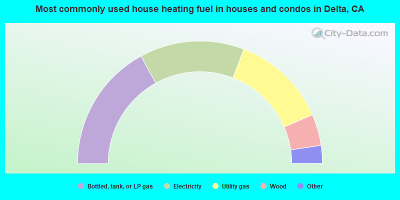
- 34.0%Bottled, tank, or LP gas
- 27.7%Electricity
- 25.3%Utility gas
- 8.3%Wood
- 3.1%Other fuel
- 1.3%Fuel oil, kerosene, etc.
- 0.3%No fuel used
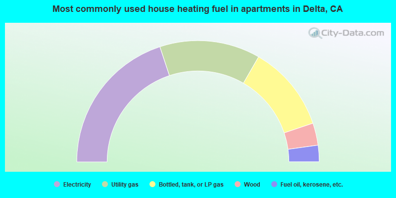
- 39.8%Electricity
- 26.8%Utility gas
- 23.0%Bottled, tank, or LP gas
- 5.9%Wood
- 4.4%Fuel oil, kerosene, etc.
Delta compared to California state average:
- Black race population percentage significantly below state average.
- Median age significantly above state average.
- Foreign-born population percentage significantly below state average.
- Renting percentage significantly below state average.
- Length of stay since moving in significantly above state average.
- Number of rooms per house significantly below state average.
- House age significantly below state average.
- Institutionalized population percentage significantly above state average.
- Percentage of population with a bachelor's degree or higher below state average.
Delta on our top lists:
- #3 on the list of "Top 101 cities with largest percentage of females in occupations: vehicle and mobile equipment mechanics, installers, and repairers (population 5,000+)"
- #6 on the list of "Top 101 cities with largest percentage of females in industries: repair and maintenance (population 5,000+)"
- #8 on the list of "Top 101 cities with largest percentage of males in industries: apparel, fabrics, and notions merchant wholesalers (population 5,000+)"
- #11 on the list of "Top 101 cities with largest percentage of females in occupations: agricultural workers including supervisors (population 5,000+)"
- #11 on the list of "Top 101 cities with largest percentage of females in industries: groceries and related products merchant wholesalers (population 5,000+)"
- #11 on the list of "Top 101 cities with largest percentage of females in occupations: information and record clerks except customer service representatives (population 5,000+)"
- #12 on the list of "Top 101 cities with largest percentage of males in industries: petroleum and petroleum products merchant wholesalers (population 5,000+)"
- #15 on the list of "Top 101 cities with largest percentage of males in occupations: vehicle and mobile equipment mechanics, installers, and repairers (population 5,000+)"
- #15 on the list of "Top 101 cities with largest percentage of males in industries: repair and maintenance (population 5,000+)"
- #16 on the list of "Top 101 cities with largest percentage of females in occupations: driver/sales workers and truck drivers (population 5,000+)"
- #16 on the list of "Top 101 cities with largest percentage of females in occupations: mathematical science occupations (population 5,000+)"
- #18 on the list of "Top 101 cities with the largest house values disparities (population 5,000+)"
- #22 on the list of "Top 101 cities with largest percentage of females in industries: farm product raw materials merchant wholesalers (population 5,000+)"
- #24 on the list of "Top 101 cities with largest percentage of females in industries: u. s. postal service (population 5,000+)"
- #36 on the list of "Top 101 cities with largest percentage of females in industries: apparel, fabrics, and notions merchant wholesalers (population 5,000+)"
- #43 on the list of "Top 101 cities with largest percentage of males in industries: warehousing and storage (population 5,000+)"
- #51 on the list of "Top 101 cities with largest percentage of females in industries: wood products (population 5,000+)"
- #54 on the list of "Top 101 cities with the largest percentage of people in agriculture workers' dormitories on farms (population 1,000+)"
- #57 on the list of "Top 101 cities with largest percentage of males in industries: retail florists (population 5,000+)"
- #69 on the list of "Top 101 cities with largest percentage of females in industries: agriculture, forestry, fishing and hunting (population 5,000+)"
- #12 on the list of "Top 101 counties with the highest percentage of residents that drank alcohol in the past 30 days"
- #18 on the list of "Top 101 counties with the highest ground withdrawal of fresh water for public supply"
- #19 on the list of "Top 101 counties with the highest total withdrawal of fresh water for public supply"
- #23 on the list of "Top 101 counties with the most Other adherents"
- #25 on the list of "Top 101 counties with the most Other congregations (pop. 50,000+)"

|
Total of 4 patent applications in 2008-2024.