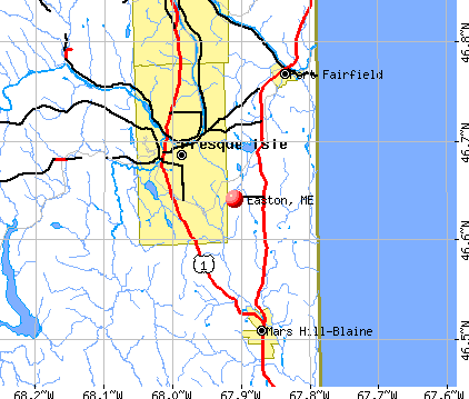
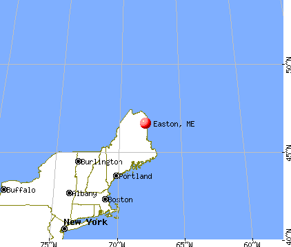
Easton, Maine

Submit your own pictures of this town and show them to the world
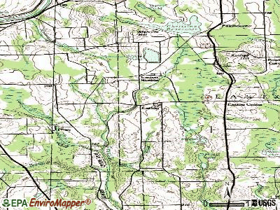
- OSM Map
- General Map
- Google Map
- MSN Map
Population change since 2000: +3.0%
 |
| Males: 639 | |
| Females: 648 |
| Median resident age: | 42.5 years |
| Maine median age: | 43.0 years |
Zip codes: 04740.
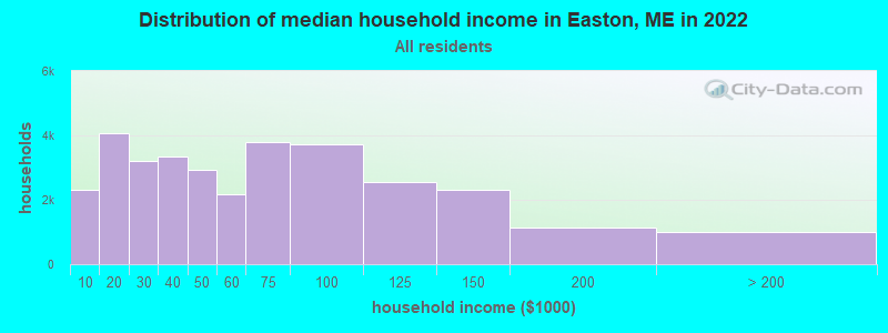
| Easton: | $53,329 |
| ME: | $69,543 |
Estimated per capita income in 2022: $31,425 (it was $15,227 in 2000)
Easton town income, earnings, and wages data
Estimated median house or condo value in 2022: $110,892 (it was $45,800 in 2000)
| Easton: | $110,892 |
| ME: | $290,600 |
Mean prices in 2022: all housing units: $179,108; detached houses: $185,023; townhouses or other attached units: $218,327; in 2-unit structures: $262,505; in 3-to-4-unit structures: $121,406; in 5-or-more-unit structures: $185,084; mobile homes: $117,009; occupied boats, rvs, vans, etc.: $12,682
Detailed information about poverty and poor residents in Easton, ME


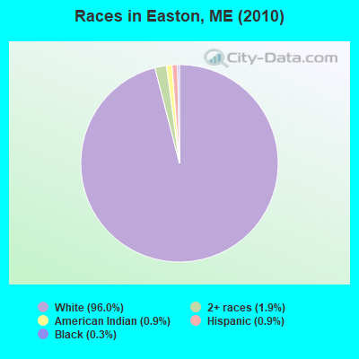
- 1,23596.0%White alone
- 241.9%Two or more races
- 120.9%American Indian alone
- 110.9%Hispanic
- 40.3%Black alone
- 10.08%Asian alone
Races in Easton detailed stats: ancestries, foreign born residents, place of birth
According to our research of Maine and other state lists, there were 4 registered sex offenders living in Easton, Maine as of April 25, 2024.
The ratio of all residents to sex offenders in Easton is 322 to 1.
 Recent articles from our blog. Our writers, many of them Ph.D. graduates or candidates, create easy-to-read articles on a wide variety of topics.


 | Why Does Northern Maine Feel So Different Than The Rest Of The Northeast? (90 replies) |
| Maple syrup today compared to 25 years ago (33 replies) |
| Why do people think I'm nuts for wanting to move to Aroostook county? (60 replies) |
| Bought a house in Limestone (43 replies) |
| Charter schools in Maine?? (83 replies) |
| Cedar shingle Roofs of Maine? (14 replies) |
Latest news from Easton, ME collected exclusively by city-data.com from local newspapers, TV, and radio stations
Ancestries: English (20.5%), Irish (15.5%), French (11.3%), United States (9.8%), German (5.8%), Scottish (5.6%).
Current Local Time: EST time zone
Incorporated on 02/24/1865
Elevation: 577 feet
Land area: 38.7 square miles.
Population density: 33 people per square mile (very low).
58 residents are foreign born (4.2% North America).
| This town: | 4.6% |
| Maine: | 2.9% |
| Easton town: | 1.5% ($681) |
| Maine: | 1.5% ($1,417) |
Nearest city with pop. 50,000+: Portland, ME  (237.9 miles , pop. 64,249).
Nearest city with pop. 200,000+: Boston, MA (339.4 miles , pop. 589,141).
Nearest city with pop. 1,000,000+: Bronx, NY (501.3 miles , pop. 1,332,650).
Nearest cities:
), ), ), ), ), )Latitude: 46.66 N, Longitude: 67.86 W
Area code: 207

Single-family new house construction building permits:
- 1997: 5 buildings, average cost: $116,000
| Here: | 3.8% |
| Maine: | 3.4% |
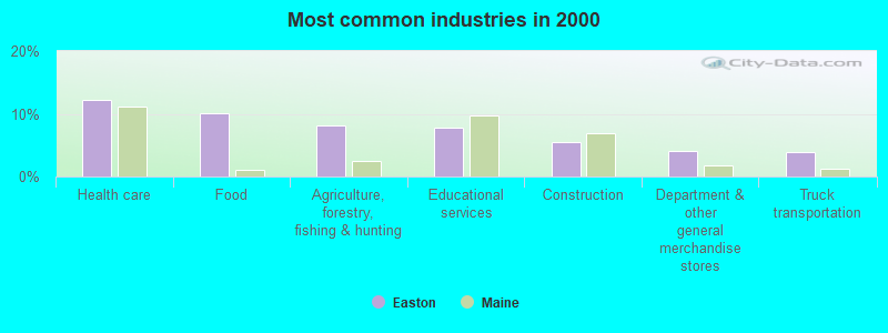
- Health care (12.3%)
- Food (10.2%)
- Agriculture, forestry, fishing & hunting (8.2%)
- Educational services (7.9%)
- Construction (5.4%)
- Department & other general merchandise stores (4.1%)
- Truck transportation (3.9%)
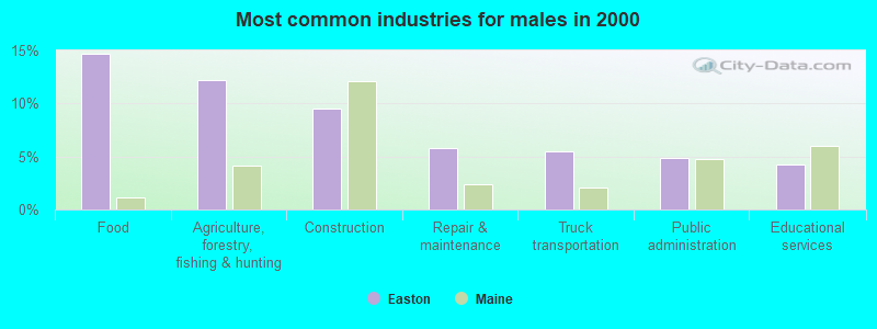
- Food (14.7%)
- Agriculture, forestry, fishing & hunting (12.2%)
- Construction (9.5%)
- Repair & maintenance (5.8%)
- Truck transportation (5.5%)
- Public administration (4.9%)
- Educational services (4.3%)
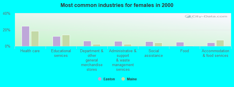
- Health care (24.4%)
- Educational services (12.0%)
- Department & other general merchandise stores (6.4%)
- Administrative & support & waste management services (6.0%)
- Social assistance (5.7%)
- Food (4.9%)
- Accommodation & food services (4.2%)
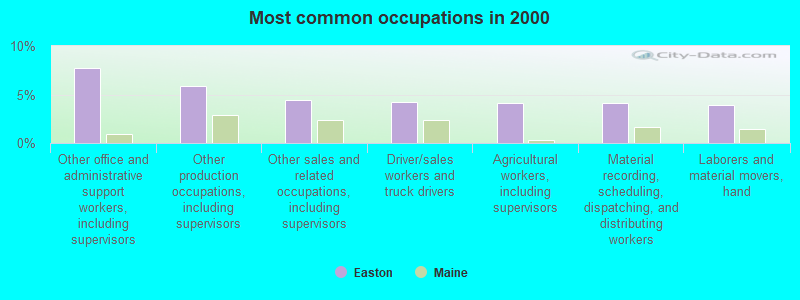
- Other office and administrative support workers, including supervisors (7.7%)
- Other production occupations, including supervisors (5.9%)
- Other sales and related occupations, including supervisors (4.4%)
- Driver/sales workers and truck drivers (4.3%)
- Agricultural workers, including supervisors (4.1%)
- Material recording, scheduling, dispatching, and distributing workers (4.1%)
- Laborers and material movers, hand (3.9%)
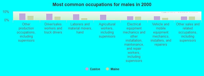
- Other production occupations, including supervisors (8.3%)
- Driver/sales workers and truck drivers (8.0%)
- Laborers and material movers, hand (7.3%)
- Agricultural workers, including supervisors (6.7%)
- Electrical equipment mechanics and other installation, maintenance, and repair workers, including supervisors (4.9%)
- Vehicle and mobile equipment mechanics, installers, and repairers (4.9%)
- Other sales and related occupations, including supervisors (4.6%)

- Other office and administrative support workers, including supervisors (13.4%)
- Secretaries and administrative assistants (8.5%)
- Material recording, scheduling, dispatching, and distributing workers (4.6%)
- Registered nurses (4.2%)
- Information and record clerks, except customer service representatives (4.2%)
- Other sales and related occupations, including supervisors (4.2%)
- Preschool, kindergarten, elementary, and middle school teachers (3.9%)
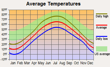
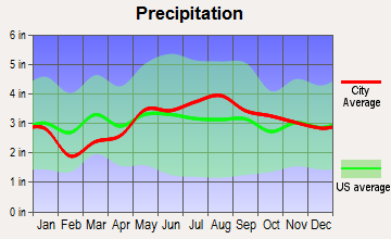
Average climate in Easton, Maine
Based on data reported by over 4,000 weather stations
(lower is better)
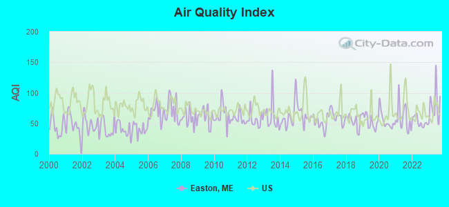
Air Quality Index (AQI) level in 2023 was 79.3. This is about average.
| City: | 79.3 |
| U.S.: | 72.6 |
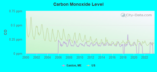
Carbon Monoxide (CO) [ppm] level in 2021 was 0.155. This is significantly better than average. Closest monitor was 8.5 miles away from the city center.
| City: | 0.155 |
| U.S.: | 0.251 |
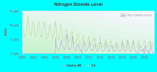
Nitrogen Dioxide (NO2) [ppb] level in 2022 was 1.41. This is significantly better than average. Closest monitor was 6.6 miles away from the city center.
| City: | 1.41 |
| U.S.: | 5.11 |
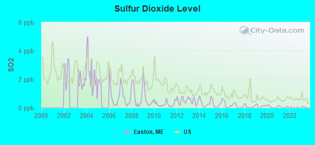
Sulfur Dioxide (SO2) [ppb] level in 2022 was 0.0234. This is significantly better than average. Closest monitor was 1.8 miles away from the city center.
| City: | 0.0234 |
| U.S.: | 1.5147 |
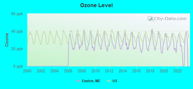
Ozone [ppb] level in 2022 was 27.2. This is better than average. Closest monitor was 6.6 miles away from the city center.
| City: | 27.2 |
| U.S.: | 33.3 |
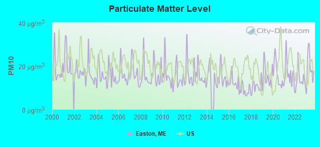
Particulate Matter (PM10) [µg/m3] level in 2023 was 19.0. This is about average. Closest monitor was 7.4 miles away from the city center.
| City: | 19.0 |
| U.S.: | 19.2 |
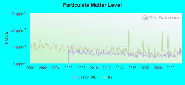
Particulate Matter (PM2.5) [µg/m3] level in 2023 was 6.47. This is better than average. Closest monitor was 7.5 miles away from the city center.
| City: | 6.47 |
| U.S.: | 8.11 |
Earthquake activity:
Easton-area historical earthquake activity is above Maine state average. It is 87% smaller than the overall U.S. average.On 7/14/2006 at 09:34:48, a magnitude 3.9 (3.9 MD, Depth: 8.6 mi, Class: Light, Intensity: II - III) earthquake occurred 41.8 miles away from Easton center
On 4/20/2002 at 10:50:47, a magnitude 5.3 (5.3 ML, Depth: 3.0 mi, Class: Moderate, Intensity: VI - VII) earthquake occurred 318.9 miles away from the city center
On 4/20/2002 at 10:50:47, a magnitude 5.2 (5.2 MB, 4.2 MS, 5.2 MW, 5.0 MW) earthquake occurred 320.6 miles away from Easton center
On 10/16/2012 at 23:12:25, a magnitude 4.7 (4.7 ML, Depth: 10.0 mi, Class: Light, Intensity: IV - V) earthquake occurred 251.7 miles away from Easton center
On 10/7/1983 at 10:18:46, a magnitude 5.3 (5.1 MB, 5.3 LG, 5.1 ML) earthquake occurred 366.3 miles away from Easton center
On 1/19/1982 at 00:14:42, a magnitude 4.7 (4.5 MB, 4.7 MD, 4.5 LG) earthquake occurred 284.5 miles away from Easton center
Magnitude types: regional Lg-wave magnitude (LG), body-wave magnitude (MB), duration magnitude (MD), local magnitude (ML), surface-wave magnitude (MS), moment magnitude (MW)
Natural disasters:
The number of natural disasters in Aroostook County (22) is greater than the US average (15).Major Disasters (Presidential) Declared: 13
Emergencies Declared: 9
Causes of natural disasters: Floods: 10, Storms: 8, Snows: 7, Heavy Rains: 2, Blizzard: 1, Hurricane: 1, Ice Storm: 1, Snowfall: 1, Snowstorm: 1, Wind: 1, Winter Storm: 1, Other: 2 (Note: some incidents may be assigned to more than one category).
Hospitals and medical centers near Easton:
- PRESQUE ISLE REHAB AND NURSING CENTER (Nursing Home, about 7 miles away; PRESQUE ISLE, ME)
- AROOSTOOK MEDICAL CENTER,THE Acute Care Hospitals (about 7 miles away; PRESQUE ISLE, ME)
- COUNTY DIALYSIS CENTER (Dialysis Facility, about 8 miles away; PRESQUE ISLE, ME)
- VALLEY HOME HEALTH SERVICES (Home Health Center, about 16 miles away; CARIBOU, ME)
- PROFESSIONAL HOME NURSING INC (Home Health Center, about 16 miles away; CARIBOU, ME)
Colleges/universities with over 2000 students nearest to Easton:
- University of Maine (about 128 miles; Orono, ME; Full-time enrollment: 8,931)
- Husson University (about 135 miles; Bangor, ME; FT enrollment: 2,421)
- University of Maine at Farmington (about 177 miles; Farmington, ME; FT enrollment: 2,036)
- University of Maine at Augusta (about 186 miles; Augusta, ME; FT enrollment: 3,204)
- Saint Joseph's College of Maine (about 234 miles; Standish, ME; FT enrollment: 2,010)
- Southern Maine Community College (about 238 miles; South Portland, ME; FT enrollment: 4,666)
- University of Southern Maine (about 239 miles; Portland, ME; FT enrollment: 6,647)
Public high school in Easton:
- EASTON JUNIOR-SENIOR HIGH SCH (Students: 79, Location: 173 CENTER RD 66, Grades: 7-12)
Public elementary/middle school in Easton:
- EASTON ELEMENTARY SCHOOL (Students: 127, Location: 33 BANGOR RD 126, Grades: PK-6)
Points of interest:
Notable location: Easton Fire Department (A). Display/hide its location on the map
Churches in Easton include: Easton Church (A), Easton United Methodist Church (B), Riviere des Chutes Church (C), Pine Tree Church (D). Display/hide their locations on the map
Cemeteries: Knight Cemetery (1), Getchell Farnham Cemetery (2), Ladner Fuller Cemetery (3), Estey Park Cemetery (4), Mount Shilo Cemetery (5), Pine Tree Church Cemetery (6). Display/hide their locations on the map
Lakes and reservoirs: Bennett Lake (A), Delano Lake (B), Dilling Lake (C), Hersom Lake (D), Lindsay Lake (E), Rand Pond (F), Lake Josephine (G). Display/hide their locations on the map
Streams, rivers, and creeks: Fling Brook (A), Elliot Brook (B), Driscoll Brook (C). Display/hide their locations on the map
Drinking water stations with addresses in Easton and their reported violations in the past:
EASTON ELEMENTARY SCHOOL (Population served: 135, Groundwater):Past monitoring violations:HUBER ENGINEERED WOODS LLC (Population served: 115, Groundwater):
- 14 regular monitoring violations
Past monitoring violations:EASTON HIGH SCHOOL (Population served: 85, Groundwater):
- Follow-up Or Routine LCR Tap M/R - In OCT-01-2008, Contaminant: Lead and Copper Rule. Follow-up actions: St Public Notif requested (DEC-09-2008), St Formal NOV issued (DEC-09-2008), St Public Notif received (FEB-24-2009), St Compliance achieved (JUN-24-2010)
- One routine major monitoring violation
Past health violations:OSGOOD FARM HOMES (Population served: 42, Groundwater):Past monitoring violations:
- MCL, Monthly (TCR) - In OCT-2010, Contaminant: Coliform. Follow-up actions: St Public Notif requested (OCT-26-2010), St Formal NOV issued (OCT-26-2010), St Public Notif received (NOV-03-2010), St Compliance achieved (NOV-15-2010)
- MCL, Monthly (TCR) - In SEP-2006, Contaminant: Coliform. Follow-up actions: St Public Notif requested (SEP-14-2006), St Violation/Reminder Notice (SEP-14-2006), St Public Notif received (SEP-25-2006), St Compliance achieved (JUN-21-2010)
- 14 regular monitoring violations
Past health violations:WEST RIDGE MANOR (Population served: 41, Groundwater):Past monitoring violations:
- MCL, Monthly (TCR) - In DEC-2006, Contaminant: Coliform. Follow-up actions: St Violation/Reminder Notice (DEC-11-2006), St Public Notif requested (DEC-11-2006), St Public Notif received (JAN-09-2007), St Compliance achieved (AUG-04-2008)
- MCL, Monthly (TCR) - In JUL-2006, Contaminant: Coliform. Follow-up actions: St Public Notif requested (JUL-17-2006), St Violation/Reminder Notice (JUL-17-2006), St Compliance achieved (AUG-04-2008), St Intentional no-action (SEP-16-2011)
- MCL, Monthly (TCR) - In JUN-2006, Contaminant: Coliform. Follow-up actions: St Public Notif requested (JUN-09-2006), St Violation/Reminder Notice (JUN-09-2006), St Public Notif received (JUL-17-2006), St Compliance achieved (AUG-04-2008)
- Monitoring and Reporting (DBP) - Between JAN-2011 and DEC-2013, Contaminant: TTHM. Follow-up actions: St Public Notif requested (JAN-06-2012), St Formal NOV issued (JAN-06-2012), St Public Notif received (JUL-16-2012), St Compliance achieved (SEP-04-2012)
- Monitoring and Reporting (DBP) - Between JAN-2011 and DEC-2013, Contaminant: Total Haloacetic Acids (HAA5). Follow-up actions: St Public Notif requested (JAN-06-2012), St Formal NOV issued (JAN-06-2012), St Public Notif received (JUL-16-2012), St Compliance achieved (SEP-04-2012)
- Follow-up Or Routine LCR Tap M/R - In OCT-01-2010, Contaminant: Lead and Copper Rule. Follow-up actions: St Public Notif requested (NOV-16-2010), St Formal NOV issued (NOV-16-2010), St Public Notif received (JUL-12-2011), St Compliance achieved (JUL-24-2012)
- 5 routine major monitoring violations
- 7 regular monitoring violations
Past health violations:MCCAIN FOODS, INC - COLD STORAGE (Population served: 29, Groundwater):
- MCL, Monthly (TCR) - In AUG-2011, Contaminant: Coliform. Follow-up actions: St Public Notif requested (AUG-18-2011), St Formal NOV issued (AUG-18-2011), St Public Notif received (AUG-29-2011), St Compliance achieved (APR-29-2013)
Past health violations:
- Treatment Technique (SWTR and GWR) - In JAN-2013, Contaminant: GROUNDWATER RULE. Follow-up actions: St Public Notif requested (FEB-25-2013), St Formal NOV issued (FEB-25-2013), St Public Notif received (MAR-19-2013)
- MCL, Monthly (TCR) - In SEP-2011, Contaminant: Coliform. Follow-up actions: St Public Notif requested (SEP-12-2011), St Formal NOV issued (SEP-12-2011), St Public Notif received (OCT-17-2011), St Compliance achieved (APR-06-2012)
- MCL, Acute (TCR) - In AUG-2011, Contaminant: Coliform. Follow-up actions: St Compliance Meeting conducted (AUG-29-2011), St Public Notif requested (AUG-29-2011), St Tech Assistance Visit (AUG-29-2011), St Formal NOV issued (AUG-29-2011), St Boil Water Order (AUG-29-2011), St Public Notif received (SEP-06-2011), St Compliance achieved (OCT-11-2011)
- MCL, Monthly (TCR) - In JUL-2011, Contaminant: Coliform. Follow-up actions: St Public Notif requested (JUL-20-2011), St Formal NOV issued (JUL-20-2011), St Public Notif received (AUG-02-2011), St Compliance achieved (2 times from AUG-23-2011 to APR-06-2012)
- MCL, Monthly (TCR) - In MAR-2011, Contaminant: Coliform. Follow-up actions: St Public Notif requested (MAR-21-2011), St Formal NOV issued (MAR-21-2011), St Public Notif received (APR-05-2011), St Compliance achieved (AUG-23-2011)
Drinking water stations with addresses in Easton that have no violations reported:
- MCCAIN FOODS USA INC (Population served: 465, Primary Water Source Type: Groundwater)
| This town: | 2.4 people |
| Maine: | 2.3 people |
| This town: | 65.7% |
| Whole state: | 62.9% |
| This town: | 9.0% |
| Whole state: | 9.4% |
Likely homosexual households (counted as self-reported same-sex unmarried-partner households)
- Lesbian couples: 0.4% of all households
- Gay men: 0.0% of all households
| This town: | 12.5% |
| Whole state: | 10.9% |
| This town: | 5.9% |
| Whole state: | 4.1% |
Banks with branches in Easton (2011 data):
- Katahdin Trust Company: Easton Branch at 82 Center Road, branch established on 1933/01/01. Info updated 2007/04/25: Bank assets: $527.8 mil, Deposits: $425.6 mil, headquarters in Patten, ME, positive income, Commercial Lending Specialization, 19 total offices, Holding Company: Katahdin Bankshares Corporation
For population 15 years and over in Easton:
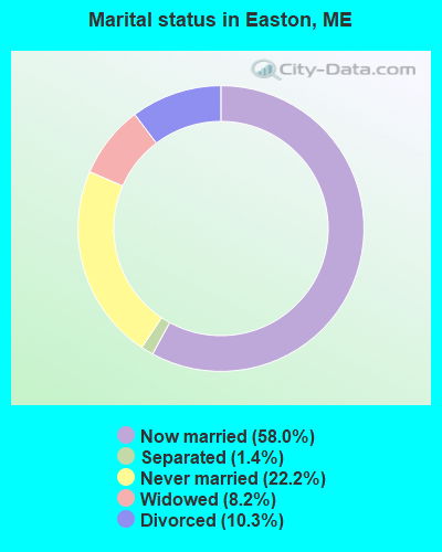
- Never married: 22.2%
- Now married: 58.0%
- Separated: 1.4%
- Widowed: 8.2%
- Divorced: 10.3%
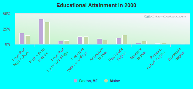
For population 25 years and over in Easton:
- High school or higher: 81.7%
- Bachelor's degree or higher: 13.9%
- Graduate or professional degree: 3.5%
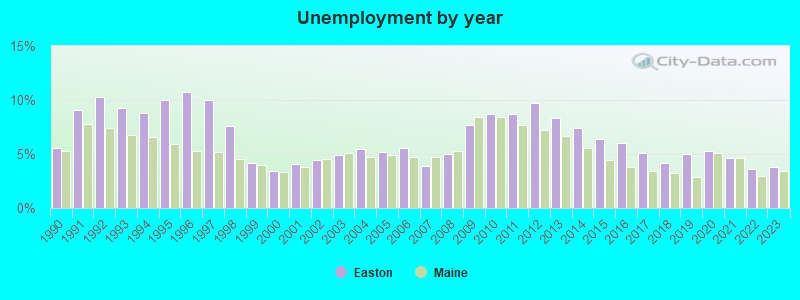
- Unemployed: 4.1%
- Mean travel time to work (commute): 19.2 minutes

| Here: | 11.2 |
| Maine average: | 11.2 |


Graphs represent county-level data. Detailed 2008 Election Results
Religion statistics for Easton, ME (based on Aroostook County data)


| Religion | Adherents | Congregations |
|---|---|---|
| Catholic | 22,200 | 27 |
| Mainline Protestant | 5,845 | 40 |
| Evangelical Protestant | 4,411 | 51 |
| Other | 957 | 7 |
| Orthodox | 10 | 1 |
| None | 38,447 | - |
Food Environment Statistics:
| Here: | 4.03 / 10,000 pop. |
| Maine: | 2.80 / 10,000 pop. |
| Aroostook County: | 0.14 / 10,000 pop. |
| State: | 0.14 / 10,000 pop. |
| Here: | 2.22 / 10,000 pop. |
| Maine: | 2.20 / 10,000 pop. |
| Here: | 7.78 / 10,000 pop. |
| Maine: | 5.75 / 10,000 pop. |
| Aroostook County: | 9.17 / 10,000 pop. |
| State: | 11.02 / 10,000 pop. |
| This county: | 11.7% |
| Maine: | 8.2% |
| Aroostook County: | 27.6% |
| Maine: | 25.0% |
Strongest AM radio stations in Easton:
- WEGP (1390 AM; 5 kW; PRESQUE ISLE, ME; Owner: DECELLES/SMITH MEDIA, INC.)
- WFST (600 AM; 5 kW; CARIBOU, ME; Owner: NORTHERN BROADCAST MINISTRIES, INC.)
- WREM (710 AM; daytime; 5 kW; MONTICELLO, ME; Owner: ALLAN H WEINER)
- WRKO (680 AM; 50 kW; BOSTON, MA; Owner: ENTERCOM BOSTON LICENSE, LLC)
- WCHP (760 AM; 35 kW; CHAMPLAIN, NY; Owner: CHAMPLAIN RADIO, INC.)
- WEEI (850 AM; 50 kW; BOSTON, MA; Owner: ENTERCOM BOSTON LICENSE, LLC)
- WNNZ (640 AM; 50 kW; WESTFIELD, MA; Owner: CLEAR CHANNEL BROADCASTING LICENSES, INC.)
- WCRN (830 AM; 50 kW; WORCESTER, MA; Owner: CARTER BROADCASTING CORPORATION)
- WBZ (1030 AM; 50 kW; BOSTON, MA; Owner: INFINITY BROADCASTING OPERATIONS, INC.)
- WZON (620 AM; 5 kW; BANGOR, ME; Owner: THE ZONE CORPORATION)
- WGY (810 AM; 50 kW; SCHENECTADY, NY; Owner: CLEAR CHANNEL BROADCASTING LICENSES, INC.)
- WALE (990 AM; 50 kW; GREENVILLE, RI; Owner: NORTH AMERICAN BROADCASTING CO., INC.)
- WKOX (1200 AM; 50 kW; FRAMINGHAM, MA; Owner: CAPSTAR TX LIMITED PARTNERSHIP)
Strongest FM radio stations in Easton:
- WQHR (96.1 FM; PRESQUE ISLE, ME; Owner: CITADEL BROADCASTING COMPANY)
- WOZI (101.9 FM; PRESQUE ISLE, ME; Owner: CITADEL BROADCASTING COMPANY)
- WBPW (96.9 FM; PRESQUE ISLE, ME; Owner: CITADEL BROADCASTING COMPANY)
- WMEM (106.1 FM; PRESQUE ISLE, ME; Owner: MAINE PUBLIC BROADCASTING CORPORATION)
- W274AF (102.7 FM; PRESQUE ISLE, ME; Owner: BANGOR BAPTIST CHURCH)
- WCXU (97.7 FM; CARIBOU, ME; Owner: THE CANXUS BROADCASTING CORPORATION)
- WUPI (92.1 FM; PRESQUE ISLE, ME; Owner: UNIVERSITY OF MAINE SYSTEM)
TV broadcast stations around Easton:
- WAGM-TV (Channel 8; PRESQUE ISLE, ME; Owner: NEPSK, INC.)
- WMEM-TV (Channel 10; PRESQUE ISLE, ME; Owner: MAINE PUBLIC BROADCASTING CORPORATION)
- W51AG (Channel 51; PRESQUE ISLE, ME; Owner: TRINITY BROADCASTING NETWORK)
- Easton, Maine
- Fatal accident count9
- Vehicles involved in fatal accidents13
- Fatal accidents involving drunk persons:2
- Fatalities9
- Persons involved in fatal accidents18
- Pedestrians involved in fatal accidents1
- Maine average
- Fatal accident count1454
- Vehicles involved in fatal accidents2091
- Fatal accidents involving drunk persons546
- Fatalities1588
- Persons involved in fatal accidents3325
- Pedestrians involved in fatal accidents155
- National Bridge Inventory (NBI) Statistics
- 1Number of bridges
- 3ft / 0.8mTotal length
- 401,000Total average daily traffic
- 20,050Total average daily truck traffic
- 16Total future (year 2036) average daily traffic
FCC Registered Broadcast Land Mobile Towers:
2- Rt 10 1 Mi E (Lat: 46.644222 Lon: -67.850028), Call Sign: KDU440,
Assigned Frequencies: 155.085 MHz, Grant Date: 08/24/2011, Expiration Date: 11/17/2021, Cancellation Date: 11/30/2011, Registrant: Aroostook Technologies, Inc., 4 Airport Dr., Presque Isle, ME 04769, Phone: (207) 762-9321
- Lat: 46.666167 Lon: -67.990861, Call Sign: KNDX698,
Assigned Frequencies: 158.392 MHz, 154.540 MHz, Grant Date: 09/20/2022, Expiration Date: 11/02/2032, Certifier: Deanna Miller, Registrant: Blooston, Mordkofsky, Dickens, Duffy & Prendergast, LLP, 2120 L Street, N.W., Suite 300, Washington, DC 20037, Phone: (202) 828-5565, Fax: (202) 828-5568, Email:
FCC Registered Amateur Radio Licenses:
11 (See the full list of FCC Registered Amateur Radio Licenses in Easton)FAA Registered Aircraft:
2- Aircraft: TAYLORCRAFT BC12-D (Category: Land, Seats: 2, Weight: Up to 12,499 Pounds, Speed: 78 mph), Engine: CONT MOTOR A&C65 SERIES (65 HP) (Reciprocating)
N-Number: 43933, N43933, N-43933, Serial Number: 7592, Year manufactured: 1946, Airworthiness Date: 12/11/1955, Certificate Issue Date: 06/02/2017
Registrant (Co-Owned): Adam G Russell, 156 Mahany Rd, Easton, ME 04740, Other Owners: Gregory H Russell - Aircraft: CESSNA 172I (Category: Land, Seats: 4, Weight: Up to 12,499 Pounds, Speed: 105 mph), Engine: LYCOMING 0-320 SERIES (180 HP) (Reciprocating)
N-Number: 8413L, N8413L, N-8413L, Serial Number: 17256613, Airworthiness Date: 03/18/1968, Certificate Issue Date: 09/02/2020
Registrant (Individual): Adam G Russell, 156 Mahany Rd, Easton, ME 04740
Deregistered: Cancel Date: 07/13/2018
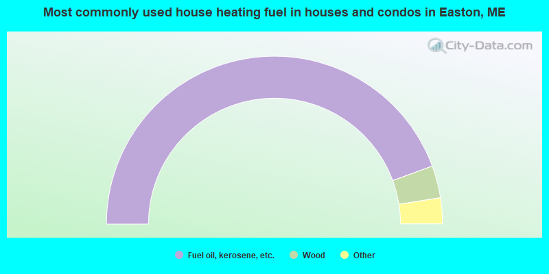
- 88.8%Fuel oil, kerosene, etc.
- 6.2%Wood
- 2.0%Bottled, tank, or LP gas
- 1.5%Coal or coke
- 1.0%Electricity
- 0.5%Solar energy
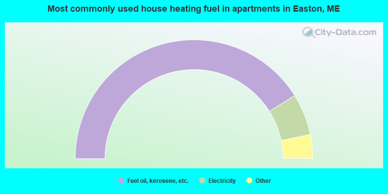
- 82.3%Fuel oil, kerosene, etc.
- 11.3%Electricity
- 3.2%Bottled, tank, or LP gas
- 1.6%Wood
- 1.6%No fuel used
Easton compared to Maine state average:
- Median house value significantly below state average.
- Unemployed percentage significantly below state average.
- Black race population percentage significantly below state average.
- Hispanic race population percentage below state average.
- Length of stay since moving in significantly above state average.
- Number of rooms per house significantly below state average.
- House age significantly below state average.
- Percentage of population with a bachelor's degree or higher below state average.
Easton on our top lists:
- #82 on the list of "Top 101 cities with the most residents born in Northern America (population 500+)"
- #82 on the list of "Top 101 cities with the most residents born in Canada (population 500+)"
- #19 on the list of "Top 101 counties with the highest carbon monoxide air pollution readings in 2012 (ppm)"
- #22 on the list of "Top 101 counties with the smallest number of children under 18 without health insurance coverage in 2000 (pop. 50,000+)"
- #29 on the list of "Top 101 counties with the lowest percentage of residents relocating from other counties between 2010 and 2011"
- #34 on the list of "Top 101 counties with the lowest percentage of residents relocating to other counties in 2011"
- #46 on the list of "Top 101 counties with the lowest Particulate Matter (PM2.5) Annual air pollution readings in 2012 (µg/m3)"

|
Total of 9 patent applications in 2008-2024.