Englewood, Ohio

Englewood: schroeder farm on west national rd. from my back yard

Englewood: At Englewood Dam
- add
your


Submit your own pictures of this city and show them to the world
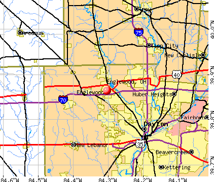
- OSM Map
- General Map
- Google Map
- MSN Map
Population change since 2000: +8.7%
 |
| Males: 6,127 | |
| Females: 7,174 |
| Median resident age: | 43.2 years |
| Ohio median age: | 39.9 years |
Zip codes: 45322.
| Englewood: | $68,629 |
| OH: | $65,720 |
Estimated per capita income in 2022: $38,051 (it was $22,792 in 2000)
Englewood city income, earnings, and wages data
Estimated median house or condo value in 2022: $186,933 (it was $113,300 in 2000)
| Englewood: | $186,933 |
| OH: | $204,100 |
Mean prices in 2022: all housing units: $186,172; detached houses: $191,148; townhouses or other attached units: $160,638; in 2-unit structures: $111,684; in 3-to-4-unit structures: $169,310; in 5-or-more-unit structures: $134,285; mobile homes: $24,861
Median gross rent in 2022: $914.
(4.3% for White Non-Hispanic residents, 10.2% for Black residents, 14.7% for Hispanic or Latino residents)
Detailed information about poverty and poor residents in Englewood, OH


Compare current foreclosures in Englewood, OH:
| Photo | Address | Area | Beds / Baths | Price | Details |
|---|---|---|---|---|---|

|
#1
Barnside Dr
Englewood, OH 45322
|
2,538 sq. feet
|
2 baths 4 beds |
show details | |

|
#2
Katy Ln
Englewood, OH 45322
|
1,519 sq. feet
|
1 baths 3 beds |
show details | |

|
#3
Northcreek Dr
Englewood, OH 45322
|
2,010 sq. feet
|
2 baths 4 beds |
show details | |

|
#4
Union Ridge Dr
Englewood, OH 45322
|
1,971 sq. feet
|
2 baths 3 beds |
show details | |

|
#5
Bearcreek Ct
Englewood, OH 45322
|
1,432 sq. feet
|
2 baths 3 beds |
show details | |

|
#6
W Martindale Rd
Englewood, OH 45322
|
1,122 sq. feet
|
1 baths 3 beds |
show details | |

|
#7
Sweet Potato Ridge Rd
Englewood, OH 45322
|
1,120 sq. feet
|
1 baths 3 beds |
show details | |

|
#8
Glenhills Dr
Englewood, OH 45322
|
972 sq. feet
|
1 baths 3 beds |
show details | |

|
#9
Brentwood Dr
Englewood, OH 45322
|
1,368 sq. feet
|
1 baths 3 beds |
show details | |

|
#10
Hitching Post Rd
Englewood, OH 45322
|
1,122 sq. feet
|
1 baths 3 beds |
show details |
| Photo | Address | Area | Beds / Baths | Price | Details |
|---|---|---|---|---|---|

|
#11
Lutz Dr
Englewood, OH 45322
|
950 sq. feet
|
1 baths 3 beds |
show details | |

|
#12
Bramlage Ln
Englewood, OH 45322
|
1,148 sq. feet
|
1 baths 3 beds |
show details | |

|
#13
Scothills Dr
Englewood, OH 45322
|
1,255 sq. feet
|
1 baths 3 beds |
show details | |

|
#14
Pepperwood Pl
Englewood, OH 45322
|
1,240 sq. feet
|
2 baths 3 beds |
show details | |

|
#15
Highland Dr
Englewood, OH 45322
|
1,680 sq. feet
|
2 baths 3 beds |
show details | |

|
#16
Scothills Dr
Englewood, OH 45322
|
1,255 sq. feet
|
1 baths 3 beds |
show details | |

|
#17
Scott Dr
Englewood, OH 45322
|
825 sq. feet
|
1 baths 1 beds |
show details | |

|
#18
Mccraw Dr
Englewood, OH 45322
|
1,213 sq. feet
|
1 baths 3 beds |
show details | |

|
#19
Michelle Pl
Englewood, OH 45322
|
1,480 sq. feet
|
1 baths 3 beds |
show details | |

|
#20
Franklin Ave
Englewood, OH 45322
|
1,116 sq. feet
|
2 baths 3 beds |
show details |
| Photo | Address | Area | Beds / Baths | Price | Details |
|---|---|---|---|---|---|

|
#21
Aleshire Farm Cir
Englewood, OH 45322
|
1,698 sq. feet
|
1 baths 3 beds |
show details | |

|
#22
Wickham Farm Dr
Englewood, OH 45322
|
1,510 sq. feet
|
1 baths 3 beds |
show details | |

|
#23
Sunset Dr
Englewood, OH 45322
|
1,432 sq. feet
|
2 baths 3 beds |
show details | |

|
#24
W Martindale Rd
Englewood, OH 45322
|
1,774 sq. feet
|
1 baths 3 beds |
show details | |

|
#25
Porter Dr
Englewood, OH 45322
|
1,665 sq. feet
|
2 baths 3 beds |
show details | |

|
#26
W Martindale Rd
Englewood, OH 45322
|
1,500 sq. feet
|
1 baths 3 beds |
show details | |

|
#27
Heather St
Englewood, OH 45322
|
2,788 sq. feet
|
4 baths 6 beds |
show details | |

|
#28
Cromer Ct
Englewood, OH 45322
|
1,714 sq. feet
|
2 baths 3 beds |
show details | |

|
#29
Kinsey Rd
Englewood, OH 45322
|
1,562 sq. feet
|
2 baths 3 beds |
show details | |

|
#30
Koerner Ave
Englewood, OH 45322
|
1,523 sq. feet
|
1 baths 3 beds |
show details |
| Photo | Address | Area | Beds / Baths | Price | Details |
|---|---|---|---|---|---|

|
#31
Heather St
Englewood, OH 45322
|
- sq. feet
|
1 baths 8 beds |
show details | |

|
#32
S Main St Apt 107
Englewood, OH 45322
|
- sq. feet
|
- baths - beds |
show details | |

|
#33
Oldham Way
Englewood, OH 45322
|
- sq. feet
|
- baths - beds |
show details | |

|
#34
Union Blvd Apt 208
Englewood, OH 45322
|
- sq. feet
|
- baths - beds |
show details | |

|
#35
Hile Ln
Englewood, OH 45322
|
- sq. feet
|
- baths - beds |
show details | |

|
#36
Browning Ave
Englewood, OH 45322
|
- sq. feet
|
- baths - beds |
show details | |

|
#37
Windpointe Way
Englewood, OH 45322
|
- sq. feet
|
- baths - beds |
show details | |

|
#38
Lauren Circle Dr
Englewood, OH 45322
|
- sq. feet
|
- baths - beds |
show details | |

|
#39
W Wenger Rd Apt 202
Englewood, OH 45322
|
- sq. feet
|
- baths - beds |
show details | |

|
#40
Union Blvd Apt 307
Englewood, OH 45322
|
- sq. feet
|
- baths - beds |
show details |
| Photo | Address | Area | Beds / Baths | Price | Details |
|---|---|---|---|---|---|

|
#41
Woodacre Ct
Englewood, OH 45322
|
- sq. feet
|
- baths - beds |
show details | |

|
Check over 1 million property listings on Foreclosure.com!
|
browse all offers | |||


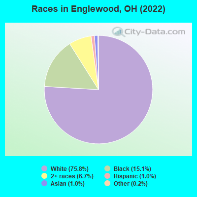
- 10,14175.8%White alone
- 2,01415.1%Black alone
- 8926.7%Two or more races
- 1371.0%Asian alone
- 1391.0%Hispanic
- 320.2%Other race alone
- 80.06%American Indian alone
- 30.02%Native Hawaiian and Other
Pacific Islander alone
Races in Englewood detailed stats: ancestries, foreign born residents, place of birth
According to our research of Ohio and other state lists, there were 14 registered sex offenders living in Englewood, Ohio as of April 23, 2024.
The ratio of all residents to sex offenders in Englewood is 962 to 1.
The ratio of registered sex offenders to all residents in this city is lower than the state average.
Type |
2009 |
2010 |
2011 |
2012 |
2013 |
2014 |
2015 |
2016 |
2017 |
2018 |
2019 |
2020 |
2021 |
2022 |
|---|---|---|---|---|---|---|---|---|---|---|---|---|---|---|
| Murders (per 100,000) | 0 (0.0) | 0 (0.0) | 0 (0.0) | 0 (0.0) | 0 (0.0) | 1 (7.4) | 0 (0.0) | 0 (0.0) | 0 (0.0) | 0 (0.0) | 0 (0.0) | 0 (0.0) | 0 (0.0) | 0 (0.0) |
| Rapes (per 100,000) | 4 (31.4) | 3 (22.3) | 1 (7.4) | 2 (14.8) | 2 (14.9) | 4 (29.7) | 11 (81.8) | 2 (14.9) | 1 (7.4) | 6 (44.5) | 1 (7.4) | 3 (22.3) | 4 (29.6) | 11 (82.5) |
| Robberies (per 100,000) | 6 (47.1) | 8 (59.4) | 8 (59.4) | 5 (37.0) | 7 (52.0) | 9 (66.8) | 4 (29.7) | 5 (37.2) | 7 (51.8) | 5 (37.1) | 8 (59.4) | 2 (14.9) | 2 (14.8) | 7 (52.5) |
| Assaults (per 100,000) | 5 (39.3) | 13 (96.5) | 5 (37.1) | 2 (14.8) | 6 (44.6) | 11 (81.7) | 3 (22.3) | 6 (44.6) | 11 (81.5) | 3 (22.3) | 7 (51.9) | 7 (52.1) | 8 (59.2) | 15 (112.5) |
| Burglaries (per 100,000) | 20 (157.1) | 46 (341.6) | 40 (296.8) | 39 (288.3) | 60 (445.9) | 35 (259.9) | 25 (185.9) | 30 (223.0) | 8 (59.2) | 27 (200.4) | 16 (118.7) | 17 (126.5) | 17 (125.9) | 16 (120.0) |
| Thefts (per 100,000) | 356 (2,796) | 364 (2,703) | 315 (2,338) | 345 (2,551) | 372 (2,765) | 434 (3,223) | 342 (2,543) | 368 (2,735) | 423 (3,132) | 363 (2,694) | 344 (2,552) | 250 (1,861) | 260 (1,925) | 293 (2,197) |
| Auto thefts (per 100,000) | 12 (94.2) | 12 (89.1) | 10 (74.2) | 11 (81.3) | 14 (104.1) | 11 (81.7) | 7 (52.0) | 12 (89.2) | 12 (88.9) | 11 (81.6) | 10 (74.2) | 6 (44.7) | 5 (37.0) | 17 (127.5) |
| Arson (per 100,000) | 1 (7.9) | 0 (0.0) | 0 (0.0) | 0 (0.0) | 0 (0.0) | 3 (22.3) | 1 (7.4) | 0 (0.0) | 5 (37.0) | 3 (22.3) | 3 (22.3) | 5 (37.2) | 1 (7.4) | 1 (7.5) |
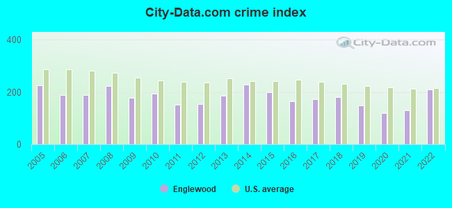
| City-Data.com crime index | 177.5 | 194.1 | 151.4 | 154.6 | 186.5 | 228.6 | 197.7 | 164.1 | 174.3 | 179.5 | 150.5 | 119.6 | 128.7 | 210.7 |
The City-Data.com crime index weighs serious crimes and violent crimes more heavily. Higher means more crime, U.S. average is 246.1. It adjusts for the number of visitors and daily workers commuting into cities.
Crime rate in Englewood detailed stats: murders, rapes, robberies, assaults, burglaries, thefts, arson
Full-time law enforcement employees in 2021, including police officers: 27 (21 officers - 21 male; 0 female).
| Officers per 1,000 residents here: | 1.55 |
| Ohio average: | 2.31 |
 Recent articles from our blog. Our writers, many of them Ph.D. graduates or candidates, create easy-to-read articles on a wide variety of topics.


 | Home Buying Stats Clayton\Englewood (24 replies) |
| Looking for One Level Ranch in Diverse Area (4 replies) |
| Relocating to Dayton best areas for Families (23 replies) |
| Englewood, Clayton, Trotwood, Dayton, and Race (12 replies) |
| Clayton/Englewood Doctors (1 reply) |
| Hey Dayton, We Made National News! (99 replies) |
Latest news from Englewood, OH collected exclusively by city-data.com from local newspapers, TV, and radio stations
Ancestries: German (16.2%), American (13.7%), English (9.5%), Irish (5.0%), Italian (4.9%), European (2.9%).
Current Local Time: EST time zone
Incorporated in 1970
Elevation: 920 feet
Land area: 6.56 square miles.
Population density: 2,028 people per square mile (low).
359 residents are foreign born (1.1% Africa, 0.8% Asia, 0.4% Latin America, 0.3% Europe).
| This city: | 2.7% |
| Ohio: | 4.9% |
Median real estate property taxes paid for housing units with mortgages in 2022: $3,296 (1.6%)
Median real estate property taxes paid for housing units with no mortgage in 2022: $2,898 (1.8%)
Nearest city with pop. 50,000+: Dayton, OH  (9.0 miles , pop. 166,179).
Nearest city with pop. 200,000+: Cincinnati, OH (51.4 miles , pop. 331,285).
Nearest city with pop. 1,000,000+: Chicago, IL (223.3 miles , pop. 2,896,016).
Nearest cities:
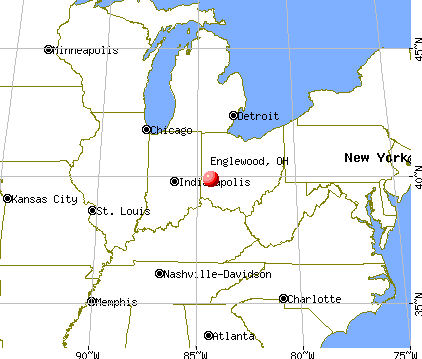
), ), ), ), ), Latitude: 39.86 N, Longitude: 84.30 W
Daytime population change due to commuting: -173 (-1.3%)
Workers who live and work in this city: 1,403 (22.7%)
Area code: 937

Englewood, Ohio accommodation & food services, waste management - Economy and Business Data
Single-family new house construction building permits:
- 2022: 2 buildings, average cost: $205,000
- 2021: 1 building, cost: $300,000
- 2020: 2 buildings, average cost: $328,000
- 2019: 1 building, cost: $195,000
- 2018: 2 buildings, average cost: $160,800
- 2017: 4 buildings, average cost: $187,500
- 2016: 6 buildings, average cost: $221,000
- 2015: 8 buildings, average cost: $215,400
- 2014: 14 buildings, average cost: $131,900
- 2013: 8 buildings, average cost: $205,000
- 2012: 6 buildings, average cost: $181,500
- 2011: 5 buildings, average cost: $186,100
- 2010: 2 buildings, average cost: $175,000
- 2009: 11 buildings, average cost: $174,800
- 2008: 11 buildings, average cost: $170,700
- 2007: 36 buildings, average cost: $185,800
- 2006: 36 buildings, average cost: $143,000
- 2005: 105 buildings, average cost: $132,500
- 2004: 110 buildings, average cost: $132,400
- 2003: 125 buildings, average cost: $132,800
- 2002: 44 buildings, average cost: $129,100
- 2001: 41 buildings, average cost: $129,100
- 2000: 110 buildings, average cost: $97,200
- 1999: 114 buildings, average cost: $97,200
- 1998: 98 buildings, average cost: $47,100
- 1997: 115 buildings, average cost: $101,900
| Here: | 3.3% |
| Ohio: | 3.1% |
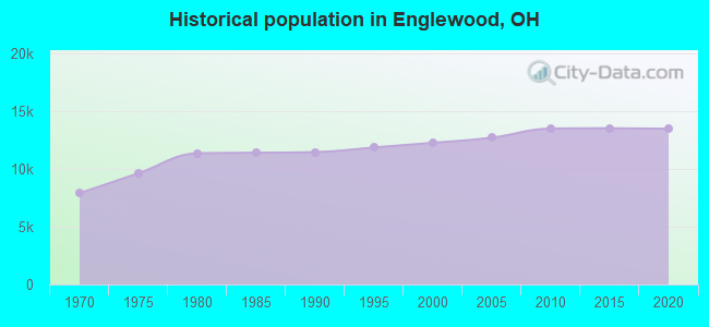
Population change in the 1990s: +599 (+5.1%).
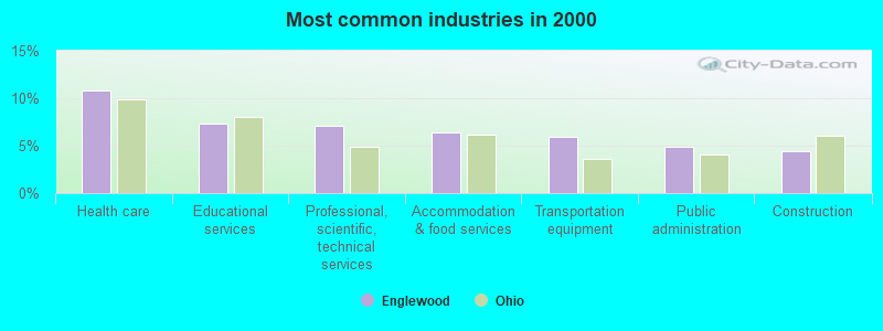
- Health care (10.8%)
- Educational services (7.3%)
- Professional, scientific, technical services (7.1%)
- Accommodation & food services (6.4%)
- Transportation equipment (5.9%)
- Public administration (4.9%)
- Construction (4.4%)
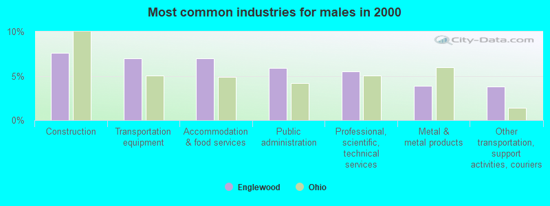
- Construction (7.6%)
- Transportation equipment (7.0%)
- Accommodation & food services (7.0%)
- Public administration (5.9%)
- Professional, scientific, technical services (5.5%)
- Metal & metal products (3.9%)
- Other transportation, support activities, couriers (3.8%)
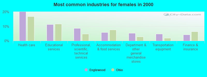
- Health care (20.0%)
- Educational services (11.3%)
- Professional, scientific, technical services (8.7%)
- Accommodation & food services (5.8%)
- Department & other general merchandise stores (5.3%)
- Transportation equipment (4.8%)
- Finance & insurance (4.3%)

- Metal workers and plastic workers (4.1%)
- Secretaries and administrative assistants (4.0%)
- Other sales and related occupations, including supervisors (3.6%)
- Other management occupations, except farmers and farm managers (3.6%)
- Registered nurses (3.4%)
- Other production occupations, including supervisors (3.4%)
- Material recording, scheduling, dispatching, and distributing workers (3.4%)
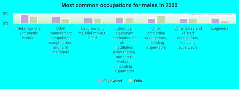
- Metal workers and plastic workers (7.2%)
- Other management occupations, except farmers and farm managers (5.3%)
- Laborers and material movers, hand (4.5%)
- Electrical equipment mechanics and other installation, maintenance, and repair workers, including supervisors (4.5%)
- Other production occupations, including supervisors (4.2%)
- Other sales and related occupations, including supervisors (4.1%)
- Engineers (3.7%)

- Secretaries and administrative assistants (8.2%)
- Registered nurses (7.1%)
- Other office and administrative support workers, including supervisors (4.5%)
- Preschool, kindergarten, elementary, and middle school teachers (4.1%)
- Material recording, scheduling, dispatching, and distributing workers (3.6%)
- Health technologists and technicians (3.4%)
- Other sales and related occupations, including supervisors (3.1%)
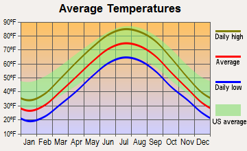
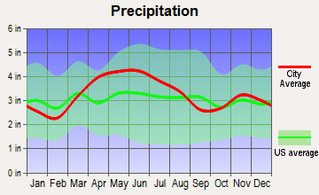
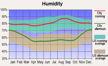
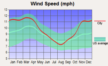
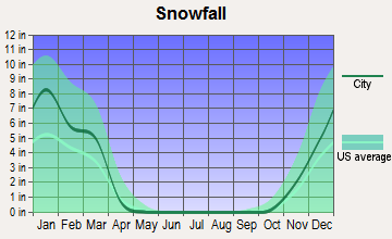
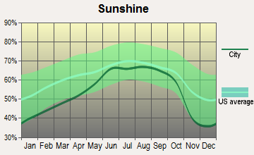
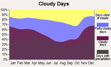
Average climate in Englewood, Ohio
Based on data reported by over 4,000 weather stations
|
|


(lower is better)
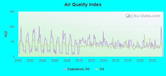
Air Quality Index (AQI) level in 2023 was 98.1. This is worse than average.
| City: | 98.1 |
| U.S.: | 72.6 |
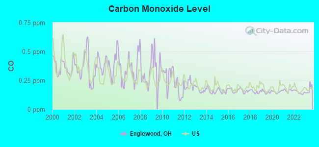
Carbon Monoxide (CO) [ppm] level in 2023 was 0.169. This is significantly better than average. Closest monitor was 6.7 miles away from the city center.
| City: | 0.169 |
| U.S.: | 0.251 |
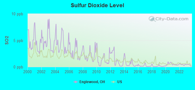
Sulfur Dioxide (SO2) [ppb] level in 2023 was 0.405. This is significantly better than average. Closest monitor was 1.9 miles away from the city center.
| City: | 0.405 |
| U.S.: | 1.515 |
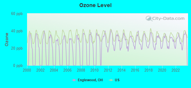
Ozone [ppb] level in 2023 was 32.5. This is about average. Closest monitor was 6.7 miles away from the city center.
| City: | 32.5 |
| U.S.: | 33.3 |
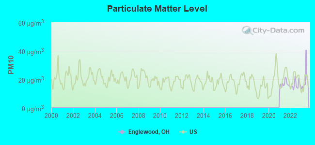
Particulate Matter (PM10) [µg/m3] level in 2023 was 19.2. This is about average. Closest monitor was 1.9 miles away from the city center.
| City: | 19.2 |
| U.S.: | 19.2 |
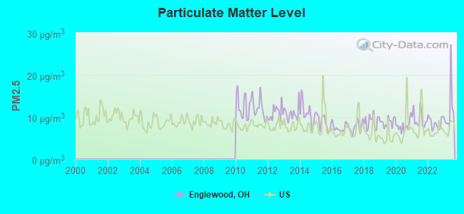
Particulate Matter (PM2.5) [µg/m3] level in 2023 was 11.7. This is significantly worse than average. Closest monitor was 9.1 miles away from the city center.
| City: | 11.7 |
| U.S.: | 8.1 |
Tornado activity:
Englewood-area historical tornado activity is slightly above Ohio state average. It is 65% greater than the overall U.S. average.
On 4/3/1974, a category F5 (max. wind speeds 261-318 mph) tornado 21.0 miles away from the Englewood city center killed 36 people and injured 1150 people and caused between $50,000,000 and $500,000,000 in damages.
On 4/25/1961, a category F4 (max. wind speeds 207-260 mph) tornado 18.5 miles away from the city center injured 7 people and caused between $500,000 and $5,000,000 in damages.
Earthquake activity:
Englewood-area historical earthquake activity is significantly above Ohio state average. It is 26% greater than the overall U.S. average.On 7/27/1980 at 18:52:21, a magnitude 5.2 (5.1 MB, 4.7 MS, 5.0 UK, 5.2 UK, Class: Moderate, Intensity: VI - VII) earthquake occurred 116.3 miles away from the city center
On 4/18/2008 at 09:36:59, a magnitude 5.4 (5.1 MB, 4.8 MS, 5.4 MW, 5.2 MW) earthquake occurred 215.5 miles away from the city center
On 7/12/1986 at 08:19:37, a magnitude 4.5 (4.5 MB, Class: Light, Intensity: IV - V) earthquake occurred 46.7 miles away from Englewood center
On 4/18/2008 at 09:36:59, a magnitude 5.2 (5.2 MW, Depth: 8.9 mi) earthquake occurred 215.5 miles away from Englewood center
On 6/10/1987 at 23:48:54, a magnitude 5.1 (4.9 MB, 4.4 MS, 4.6 MS, 5.1 LG) earthquake occurred 204.7 miles away from the city center
On 9/25/1998 at 19:52:52, a magnitude 5.2 (4.8 MB, 4.3 MS, 5.2 LG, 4.5 MW, Depth: 3.1 mi) earthquake occurred 233.8 miles away from Englewood center
Magnitude types: regional Lg-wave magnitude (LG), body-wave magnitude (MB), surface-wave magnitude (MS), moment magnitude (MW)
Natural disasters:
The number of natural disasters in Montgomery County (9) is smaller than the US average (15).Major Disasters (Presidential) Declared: 4
Emergencies Declared: 3
Causes of natural disasters: Floods: 4, Storms: 3, Mudslides: 2, Winds: 2, Blizzard: 1, Heavy Rain: 1, Hurricane: 1, Landslide: 1, Snow: 1, Snowstorm: 1, Tornado: 1, Tropical Depression: 1, Winter Storm: 1, Other: 1 (Note: some incidents may be assigned to more than one category).

Hospitals and medical centers in Englewood:
Colleges/universities with over 2000 students nearest to Englewood:
- Sinclair Community College (about 10 miles; Dayton, OH; Full-time enrollment: 13,779)
- University of Dayton (about 12 miles; Dayton, OH; FT enrollment: 10,392)
- Wright State University-Main Campus (about 14 miles; Dayton, OH; FT enrollment: 14,482)
- Fortis College-Centerville (about 18 miles; Centerville, OH; FT enrollment: 4,527)
- Edison State Community College (about 21 miles; Piqua, OH; FT enrollment: 2,049)
- Central State University (about 25 miles; Wilberforce, OH; FT enrollment: 2,094)
- Clark State Community College (about 27 miles; Springfield, OH; FT enrollment: 3,689)
Public high schools in Englewood:
Public elementary/middle schools in Englewood:
- NORTHMOOR ELEMENTARY SCHOOL (Students: 575, Location: 4421 OLD SALEM RD, Grades: 2-7)
- ENGLEWOOD HILLS ELEMENTARY SCHOOL (Students: 371, Location: 508 DURST DR, Grades: 2-6)
- ENGLEWOOD ELEMENTARY SCHOOL (Students: 298, Location: 702 ALBERT ST, Grades: 2-6)
Points of interest:
Notable locations in Englewood: Englewood Industrial Park (A), Englewood Fire Department Station 98 (B), Englewood Fire Department Station 2 (C), Earl Heck Community Center (D), Deeter Nurseries (E). Display/hide their locations on the map
Shopping Centers: Englewood Plaza Shopping Center (1), Country Square Shopping Center (2), Golden Key Village Shopping Center (3), Northmont Plaza Shopping Center (4). Display/hide their locations on the map
Churches in Englewood include: Concord Church (A), Grace Church (B), Englewood United Methodist Church (C). Display/hide their locations on the map
Cemeteries: Fairview Cemetery (1), Concord Cemetery (2), Happy Corner Cemetery (3). Display/hide their locations on the map
Parks in Englewood include: Government Park (1), Heathcliff Wellfield Park (2), Oberer Field (3), Englewood Municipal Park (4), Englewood Hills South Park (5). Display/hide their locations on the map
Hotels: Dayton Airport - Englewood (1212 S Main St), Cross Country Inn (9325 North Main Street), Hampton Inn Dayton-NW (20 Rockridge Road).
Birthplace of: Jeff Hamilton - NHL player (New York Islanders, born: Sep 4, 1977), Jeff Hamilton (ice hockey) - Ice hockey player.
Drinking water stations with addresses in Englewood and their reported violations in the past:
ENGLEWOOD CITY PWS (Population served: 12,500, Groundwater):Past health violations:SALEM CHURCH OF THE BRETHREN PWS (Population served: 125, Groundwater):Past monitoring violations:
- MCL, Monthly (TCR) - In MAR-2005, Contaminant: Coliform. Follow-up actions: St Violation/Reminder Notice (MAR-08-2005), St Public Notif requested (MAR-08-2005), St Public Notif received (MAR-30-2005), St Compliance achieved (APR-19-2007)
- Lead Consumer Notice - In DEC-31-2012, Contaminant: Lead and Copper Rule. Follow-up actions: St Violation/Reminder Notice (FEB-01-2013), St Compliance achieved (FEB-20-2013)
Past health violations:Past monitoring violations:
- MCL, Monthly (TCR) - Between OCT-2012 and DEC-2012, Contaminant: Coliform. Follow-up actions: St Violation/Reminder Notice (DEC-20-2012), St Public Notif requested (DEC-20-2012)
- One routine major monitoring violation
- One regular monitoring violation
| This city: | 2.4 people |
| Ohio: | 2.4 people |
| This city: | 66.4% |
| Whole state: | 65.0% |
| This city: | 4.7% |
| Whole state: | 6.8% |
Likely homosexual households (counted as self-reported same-sex unmarried-partner households)
- Lesbian couples: 0.3% of all households
- Gay men: 0.3% of all households
172 people in nursing homes in 2000
3 people in homes for the mentally retarded in 2000
Banks with branches in Englewood (2011 data):
- Fifth Third Bank: Englewood Branch at 310 West National Road, branch established on 1969/02/10; Englewood Banking Center at 825 S Union Rd, branch established on 1934/08/01. Info updated 2009/10/05: Bank assets: $114,540.4 mil, Deposits: $89,689.1 mil, headquarters in Cincinnati, OH, positive income, Commercial Lending Specialization, 1378 total offices, Holding Company: Fifth Third Bancorp
- KeyBank National Association: Englewood Branch at 511 West National Road, branch established on 1976/04/26. Info updated 2008/03/03: Bank assets: $86,198.8 mil, Deposits: $64,214.8 mil, headquarters in Cleveland, OH, positive income, Commercial Lending Specialization, 1067 total offices, Holding Company: Keycorp
- The Huntington National Bank: Englewood Branch at 800 West Wenger Road, branch established on 1981/07/15. Info updated 2012/04/02: Bank assets: $54,183.4 mil, Deposits: $44,300.3 mil, headquarters in Columbus, OH, positive income, Commercial Lending Specialization, 878 total offices, Holding Company: Huntington Bancshares Incorporated
- Union Savings Bank: Englewood Branch at 525 West National Road, branch established on 1997/04/29. Info updated 2012/01/04: Bank assets: $2,218.6 mil, Deposits: $1,997.4 mil, headquarters in Cincinnati, OH, positive income, Mortgage Lending Specialization, 25 total offices
- PNC Bank, National Association: Englewood Branch at 175 West National Road, branch established on 1966/06/20. Info updated 2012/03/20: Bank assets: $263,309.6 mil, Deposits: $197,343.0 mil, headquarters in Wilmington, DE, positive income, Commercial Lending Specialization, 3085 total offices, Holding Company: Pnc Financial Services Group, Inc., The
- JPMorgan Chase Bank, National Association: Englewood Branch at 604 Taywood Road, branch established on 1979/08/09. Info updated 2011/11/10: Bank assets: $1,811,678.0 mil, Deposits: $1,190,738.0 mil, headquarters in Columbus, OH, positive income, International Specialization, 5577 total offices, Holding Company: Jpmorgan Chase & Co.
- Liberty Savings Bank, F.S.B.: Englewood Branch at 330 West National Road, branch established on 1991/10/01. Info updated 2011/07/21: Bank assets: $683.0 mil, Deposits: $553.2 mil, headquarters in Wilmington, OH, positive income, Mortgage Lending Specialization, 33 total offices
For population 15 years and over in Englewood:
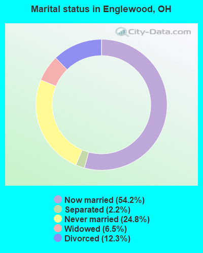
- Never married: 24.8%
- Now married: 54.2%
- Separated: 2.2%
- Widowed: 6.5%
- Divorced: 12.3%
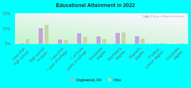
For population 25 years and over in Englewood:
- High school or higher: 97.8%
- Bachelor's degree or higher: 30.4%
- Graduate or professional degree: 11.8%
- Unemployed: 3.4%
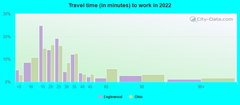
- Mean travel time to work (commute): 23.6 minutes
| Here: | 8.6 |
| Ohio average: | 11.0 |
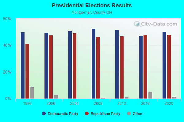
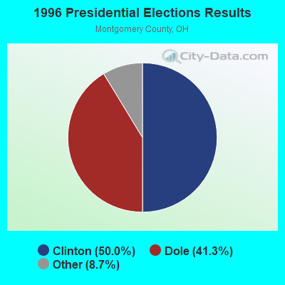
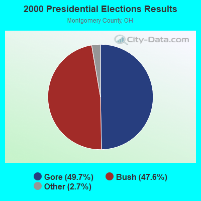
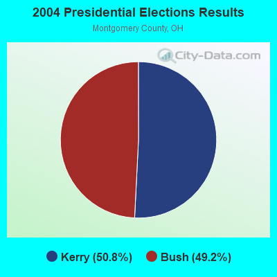
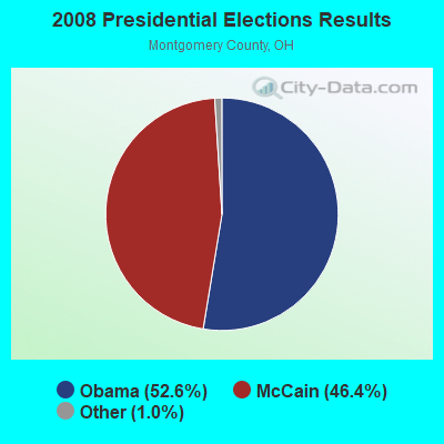

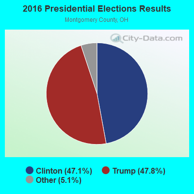
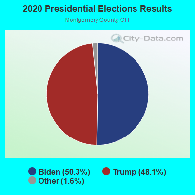
Graphs represent county-level data. Detailed 2008 Election Results
Religion statistics for Englewood, OH (based on Montgomery County data)
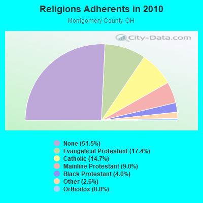
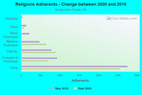
| Religion | Adherents | Congregations |
|---|---|---|
| Evangelical Protestant | 93,334 | 306 |
| Catholic | 78,909 | 34 |
| Mainline Protestant | 47,961 | 143 |
| Black Protestant | 21,263 | 56 |
| Other | 14,123 | 41 |
| Orthodox | 4,205 | 3 |
| None | 275,358 | - |
Food Environment Statistics:
| Here: | 1.52 / 10,000 pop. |
| Ohio: | 1.89 / 10,000 pop. |
| This county: | 0.15 / 10,000 pop. |
| Ohio: | 0.13 / 10,000 pop. |
| Here: | 1.39 / 10,000 pop. |
| State: | 1.25 / 10,000 pop. |
| Montgomery County: | 2.31 / 10,000 pop. |
| State: | 2.93 / 10,000 pop. |
| This county: | 5.76 / 10,000 pop. |
| State: | 6.25 / 10,000 pop. |
| Montgomery County: | 11.0% |
| State: | 10.3% |
| This county: | 30.5% |
| Ohio: | 29.1% |
| This county: | 9.3% |
| Ohio: | 11.9% |
Health and Nutrition:
| Englewood: | 51.7% |
| State: | 50.4% |
| This city: | 49.0% |
| Ohio: | 47.8% |
| Here: | 28.8 |
| State: | 28.7 |
| Englewood: | 19.3% |
| Ohio: | 20.6% |
| This city: | 10.6% |
| Ohio: | 10.4% |
| This city: | 6.9 |
| State: | 6.8 |
| Englewood: | 34.8% |
| Ohio: | 34.3% |
| Englewood: | 58.5% |
| Ohio: | 57.0% |
| Englewood: | 78.2% |
| Ohio: | 79.1% |
More about Health and Nutrition of Englewood, OH Residents
| Local government employment and payroll (March 2022) | |||||
| Function | Full-time employees | Monthly full-time payroll | Average yearly full-time wage | Part-time employees | Monthly part-time payroll |
|---|---|---|---|---|---|
| Firefighters | 28 | $178,421 | $76,466 | 13 | $20,394 |
| Police Protection - Officers | 23 | $161,430 | $84,224 | 0 | $0 |
| Other Government Administration | 10 | $35,305 | $42,366 | 8 | $2,880 |
| Streets and Highways | 10 | $61,094 | $73,313 | 0 | $0 |
| Police - Other | 7 | $35,845 | $61,449 | 5 | $8,594 |
| Financial Administration | 6 | $37,366 | $74,732 | 0 | $0 |
| Other and Unallocable | 3 | $17,203 | $68,812 | 2 | $2,473 |
| Water Supply | 3 | $18,126 | $72,504 | 0 | $0 |
| Parks and Recreation | 2 | $12,757 | $76,542 | 1 | $2,002 |
| Totals for Government | 92 | $557,546 | $72,723 | 29 | $36,342 |
Englewood government finances - Expenditure in 2018 (per resident):
- Construction - Water Utilities: $786,000 ($59.09)
Sewerage: $766,000 ($57.59)
Regular Highways: $668,000 ($50.22)
Parks and Recreation: $442,000 ($33.23)
General - Other: $232,000 ($17.44)
General Public Buildings: $37,000 ($2.78)
Housing and Community Development: $28,000 ($2.11)
Local Fire Protection: $11,000 ($0.83)
- Current Operations - Police Protection: $2,717,000 ($204.27)
Local Fire Protection: $1,807,000 ($135.85)
Regular Highways: $1,592,000 ($119.69)
General - Other: $1,481,000 ($111.35)
Central Staff Services: $1,165,000 ($87.59)
Sewerage: $1,100,000 ($82.70)
Water Utilities: $829,000 ($62.33)
Solid Waste Management: $812,000 ($61.05)
Financial Administration: $506,000 ($38.04)
Parks and Recreation: $329,000 ($24.73)
Housing and Community Development: $27,000 ($2.03)
Miscellaneous Commercial Activities - Other: $5,000 ($0.38)
- Intergovernmental to Local - Other - General - Other: $135,000 ($10.15)
Other - Sewerage: $115,000 ($8.65)
Other - Financial Administration: $27,000 ($2.03)
Other - Police Protection: $2,000 ($0.15)
- Intergovernmental to State - Sewerage: $10,000 ($0.75)
Water Utilities: $9,000 ($0.68)
Police Protection: $7,000 ($0.53)
Financial Administration: $1,000 ($0.08)
- Other Capital Outlay - Local Fire Protection: $291,000 ($21.88)
Regular Highways: $212,000 ($15.94)
Sewerage: $150,000 ($11.28)
Water Utilities: $94,000 ($7.07)
Police Protection: $82,000 ($6.16)
General Public Building: $65,000 ($4.89)
General - Other: $20,000 ($1.50)
Parks and Recreation: $1,000 ($0.08)
- Total Salaries and Wages: $6,007,000 ($451.62)
Englewood government finances - Revenue in 2018 (per resident):
- Charges - Sewerage: $1,335,000 ($100.37)
Other: $1,196,000 ($89.92)
Solid Waste Management: $811,000 ($60.97)
Parks and Recreation: $15,000 ($1.13)
Miscellaneous Commercial Activities: $8,000 ($0.60)
- Federal Intergovernmental - Other: $3,000 ($0.23)
- Local Intergovernmental - Highways: $173,000 ($13.01)
General Local Government Support: $140,000 ($10.53)
Housing and Community Development: $74,000 ($5.56)
Other: $71,000 ($5.34)
- Miscellaneous - General Revenue - Other: $565,000 ($42.48)
Interest Earnings: $304,000 ($22.86)
Special Assessments: $177,000 ($13.31)
Sale of Property: $71,000 ($5.34)
Fines and Forfeits: $38,000 ($2.86)
Rents: $19,000 ($1.43)
Donations From Private Sources: $4,000 ($0.30)
- Revenue - Water Utilities: $1,313,000 ($98.71)
- State Intergovernmental - Highways: $462,000 ($34.73)
General Local Government Support: $214,000 ($16.09)
Other: $62,000 ($4.66)
- Tax - Individual Income: $6,328,000 ($475.75)
Property: $1,418,000 ($106.61)
Corporation Net Income: $868,000 ($65.26)
Other License: $249,000 ($18.72)
Public Utilities Sales: $165,000 ($12.41)
Occupation and Business License - Other: $131,000 ($9.85)
Motor Vehicle License: $66,000 ($4.96)
Public Utility License: $22,000 ($1.65)
Alcoholic Beverage License: $18,000 ($1.35)
Death and Gift: $5,000 ($0.38)
Tobacco Products Sales: $1,000 ($0.08)
Englewood government finances - Cash and Securities in 2018 (per resident):
- Other Funds - Cash and Securities: $22,697,000 ($1706.41)
- Sinking Funds - Cash and Securities: $1,227,000 ($92.25)
5.90% of this county's 2021 resident taxpayers lived in other counties in 2020 ($51,044 average adjusted gross income)
| Here: | 5.90% |
| Ohio average: | 5.68% |
0.06% of residents moved from foreign countries ($588 average AGI)
Montgomery County: 0.06% Ohio average: 0.01%
Top counties from which taxpayers relocated into this county between 2020 and 2021:
| from Greene County, OH | |
| from Warren County, OH | |
| from Miami County, OH |
6.00% of this county's 2020 resident taxpayers moved to other counties in 2021 ($58,304 average adjusted gross income)
| Here: | 6.00% |
| Ohio average: | 5.79% |
0.04% of residents moved to foreign countries ($390 average AGI)
Montgomery County: 0.04% Ohio average: 0.01%
Top counties to which taxpayers relocated from this county between 2020 and 2021:
| to Greene County, OH | |
| to Warren County, OH | |
| to Miami County, OH |
| Businesses in Englewood, OH | ||||
| Name | Count | Name | Count | |
|---|---|---|---|---|
| Advance Auto Parts | 1 | Kmart | 1 | |
| Arby's | 1 | Kroger | 1 | |
| Best Western | 1 | Long John Silver's | 1 | |
| Blockbuster | 1 | MasterBrand Cabinets | 1 | |
| Buffalo Wild Wings | 1 | McDonald's | 1 | |
| Burger King | 1 | Pizza Hut | 1 | |
| Cricket Wireless | 1 | Rite Aid | 1 | |
| DHL | 1 | SONIC Drive-In | 1 | |
| Dairy Queen | 1 | Starbucks | 1 | |
| Fashion Bug | 1 | Super 8 | 1 | |
| FedEx | 2 | T-Mobile | 1 | |
| GNC | 1 | Taco Bell | 1 | |
| Goodwill | 2 | Tim Hortons | 1 | |
| H&R Block | 1 | UPS | 3 | |
| Hilton | 1 | Walgreens | 1 | |
| Holiday Inn | 1 | Wendy's | 1 | |
| KFC | 1 | YMCA | 1 | |
Strongest AM radio stations in Englewood:
- WLW (700 AM; 50 kW; CINCINNATI, OH; Owner: JACOR BROADCASTING CORPORATION)
- WONE (980 AM; 5 kW; DAYTON, OH; Owner: CITICASTERS LICENSES, L.P.)
- WING (1410 AM; 5 kW; DAYTON, OH)
- WHIO (1290 AM; 5 kW; DAYTON, OH; Owner: CXR HOLDINGS, INC.)
- WTVN (610 AM; 50 kW; COLUMBUS, OH; Owner: CITICASTERS LICENSES, L.P.)
- WSAI (1530 AM; 50 kW; CINCINNATI, OH; Owner: JACOR BROADCASTING CORPORATION)
- WDAO (1210 AM; daytime; 1 kW; DAYTON, OH; Owner: JOHNSON COMMUNICATIONS, INC.)
- WRFD (880 AM; daytime; 23 kW; COLUMBUS-WORTHINGTON, OH; Owner: SALEM MEDIA OF OHIO, INC.)
- WGNZ (1110 AM; daytime; 2 kW; FAIRBORN, OH; Owner: L&D BROADCASTORS INC.)
- WOWO (1190 AM; 50 kW; FORT WAYNE, IN; Owner: PATHFINDER COMMUNICATIONS CORPORATION)
- WIBC (1070 AM; 50 kW; INDIANAPOLIS, IN; Owner: EMMIS RADIO LICENSE CORPORATION)
- WHAS (840 AM; 50 kW; LOUISVILLE, KY; Owner: CLEAR CHANNEL BROADCASTING LICENSES, INC.)
- WKRC (550 AM; 5 kW; CINCINNATI, OH; Owner: JACOR BROADCASTING CORPORATION)
Strongest FM radio stations in Englewood:
- WDKF (94.5 FM; ENGLEWOOD, OH; Owner: CITICASTERS LICENSES, L.P.)
- WGTZ (92.9 FM; EATON, OH; Owner: BLUE CHIP BROADCASTING LICENSES, LTD)
- WHKO (99.1 FM; DAYTON, OH; Owner: CXR HOLDINGS, INC.)
- WLQT (99.9 FM; KETTERING, OH; Owner: CITICASTERS LICENSES, L.P.)
- WMMX (107.7 FM; DAYTON, OH; Owner: CITICASTERS LICENSES, L.P.)
- WTUE (104.7 FM; DAYTON, OH; Owner: CITICASTERS LICENSES, L.P.)
- WRNB (92.1 FM; WEST CARROLLTON, OH; Owner: RADIO ONE OF DAYTON LICENSES, LLC)
- WXEG (103.9 FM; BEAVERCREEK, OH; Owner: CITICASTERS LICENSES, L.P.)
- WQRP (89.5 FM; DAYTON, OH; Owner: WQRP FAMILY RADIO, INC.)
- WFCJ (93.7 FM; MIAMISBURG, OH; Owner: MIAMI VALLEY CHRISTIAN BROADCASTING ASSOCIATION)
- WDPR (88.1 FM; WEST CARROLLTON, OH; Owner: DAYTON PUBLIC RADIO, INC.)
- WOKL (96.9 FM; TROY, OH; Owner: EDUCATIONAL MEDIA FOUNDATION)
- WDPS (89.5 FM; DAYTON, OH; Owner: DAYTON CITY SCHOOLS)
- WPFB-FM (105.9 FM; MIDDLETOWN, OH; Owner: RADIO STATIONS WPAY/WPFB, INC.)
- WRVT (88.7 FM; RUTLAND, VT; Owner: VERMONT PUBLIC RADIO)
- WMOJ (94.9 FM; FAIRFIELD, OH; Owner: WVAE LICO, INC.)
- WDHT (102.9 FM; SPRINGFIELD, OH; Owner: BLUE CHIP BROADCASTING LICENSES, LTD)
- WYGY (96.5 FM; LEBANON, OH; Owner: WVAE LICO, INC.)
- WEEC (100.7 FM; SPRINGFIELD, OH; Owner: WORLD EVENGELISTIC ENTERPRISE CORP.)
- WDPT (95.7 FM; PIQUA, OH; Owner: CXR HOLDINGS, INC.)
TV broadcast stations around Englewood:
- WHIO-TV (Channel 7; DAYTON, OH; Owner: WHIO-TV HOLDINGS, INC.)
- WDTN (Channel 2; DAYTON, OH; Owner: WDTN BROADCASTING, LLC)
- WKEF (Channel 22; DAYTON, OH; Owner: WKEF LICENSEE L.P.)
- WRGT-TV (Channel 45; DAYTON, OH; Owner: WRGT LICENSEE, LLC)
- WPTD (Channel 16; DAYTON, OH; Owner: GREATER DAYTON PUBLIC TV, INC.)
- W61DE (Channel 61; CINCINNATI, OH; Owner: TRINITY BROADCASTING NETWORK)
- WRCX-LP (Channel 51; DAYTON, OH; Owner: ROSS COMMUNICATIONS, LTD.)
- WBDT (Channel 26; SPRINGFIELD, OH; Owner: ACME TV LICENSES OF OHIO, LLC)
- WKOI (Channel 43; RICHMOND, IN; Owner: TRINITY BROADCASTING OF INDIANA, INC.)
- WPTO (Channel 14; OXFORD, OH; Owner: GREATER DAYTON PUBLIC TELEVISION, INC.)
- WWRD-LP (Channel 55; CENTERVILLE, OH; Owner: LIFE BROADCASTING NETWORK)
- W47BC (Channel 47; SPRINGFIELD, OH; Owner: TRINITY BROADCASTING NETWORK)
- National Bridge Inventory (NBI) Statistics
- 13Number of bridges
- 144ft / 44.3mTotal length
- 364,011Total average daily traffic
- 76,636Total average daily truck traffic
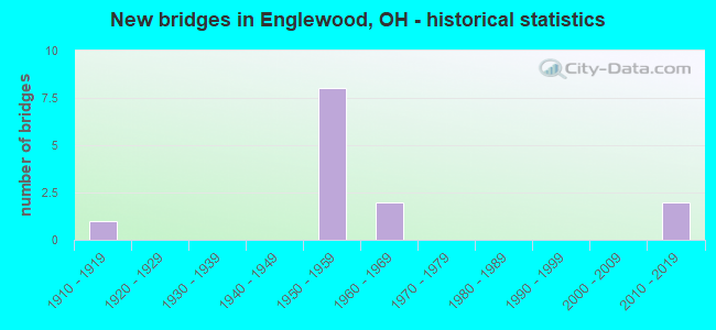
- New bridges - historical statistics
- 11910-1919
- 81950-1959
- 21960-1969
- 22010-2019
FCC Registered Antenna Towers:
11 (See the full list of FCC Registered Antenna Towers in Englewood)FCC Registered Broadcast Land Mobile Towers:
4- Bayberry 5940 Mount Royal (Lat: 39.836722 Lon: -84.317167), Call Sign: WNQE650, Licensee ID: L00003223,
Assigned Frequencies: 173.287 MHz, Grant Date: 06/16/1999, Expiration Date: 08/21/2004, Cancellation Date: 09/06/2002, Registrant: County Of Montgomery, 2712 Springboro Pike, Dayton, OH 45439, Phone: (513) 297-5009
- Savina At Rt 48 9111 (Lat: 39.855056 Lon: -84.275222), Call Sign: WNQF672,
Assigned Frequencies: 173.287 MHz, Grant Date: 06/21/1999, Expiration Date: 09/01/2004, Cancellation Date: 09/06/2002, Registrant: County Of Montgomery, 2712 Springboro Pike, Dayton, OH 45439, Phone: (513) 297-5009
- 300 Smith Drive (Lat: 39.856389 Lon: -84.326944), Type: Pole, Structure height: 33 m, Overall height: 37 m, Call Sign: WPRV346, Licensee ID: L00007339,
Assigned Frequencies: 47.2200 MHz, 47.0200 MHz, Grant Date: 11/17/2010, Expiration Date: 02/13/2021, Cancellation Date: 02/02/2015, Certifier: Kenny S Brooks, Registrant: State Of Ohio, 1980 West Broad St, Columbus, OH 43223, Phone: (614) 752-0404, Fax: (614) 728-5590, Email:
- Lat: 39.852500 Lon: -84.326417, Call Sign: WROD748,
Assigned Frequencies: 451.912 MHz, 456.912 MHz, 461.462 MHz, 461.487 MHz, 462.025 MHz, 462.062 MHz, 466.462 MHz, 466.487 MHz, 467.025 MHz, 467.062 MHz, Grant Date: 09/29/2021, Expiration Date: 09/29/2031, Certifier: Jamie Grant, Registrant: Bearcom Operating LLC, P.O. Box 559001, Dallas, TX 75355-9001, Phone: (800) 458-9887, Email:
FCC Registered Microwave Towers:
6- ENGLE PD WT, Hoke Road Wt (Lat: 39.857917 Lon: -84.328528), Type: Tank, Structure height: 45.7 m, Call Sign: WQCJ259,
Assigned Frequencies: 10628.1 MHz, Grant Date: 03/16/2005, Expiration Date: 03/16/2015, Cancellation Date: 05/16/2015, Certifier: Mark B Brownfield, Registrant: Comsearch, 19700 Janelia Farm Blvd, Ashburn, VA 20147, Phone: (703) 726-5671, Fax: (703) 726-5594, Email:
- OH0063, Rt. 49 (Lat: 39.852806 Lon: -84.332194), Type: Pole, Structure height: 48.7 m, Call Sign: WQMP220,
Assigned Frequencies: 11485.0 MHz, 11345.0 MHz, 11585.0 MHz, 11245.0 MHz, Grant Date: 10/08/2010, Expiration Date: 10/08/2020, Cancellation Date: 02/16/2012, Certifier: Dan Mieszala, Registrant: Open Range Communications Inc., 6430 S. Fiddlers Green Circle, Suite 500, Greenwood Village, CO 80111, Phone: (303) 376-2112, Fax: (303) 376-2109, Email:
- OH0119, 90 Rockridge Rd. (Lat: 39.858778 Lon: -84.286972), Type: Pole, Structure height: 59.7 m, Call Sign: WQMP222,
Assigned Frequencies: 11285.0 MHz, Grant Date: 10/08/2010, Expiration Date: 10/08/2020, Cancellation Date: 02/16/2012, Certifier: Dan Mieszala, Registrant: Open Range Communications Inc., 6430 S. Fiddlers Green Circle, Suite 500, Greenwood Village, CO 80111, Phone: (303) 376-2112, Fax: (303) 376-2109, Email:
- OH0126B, Union Blvd., Just South Of National Road (Lat: 39.875028 Lon: -84.312250), Type: Tank, Structure height: 33.2 m, Overall height: 35.2 m, Call Sign: WQMP575,
Assigned Frequencies: 19330.0 MHz, Grant Date: 10/14/2010, Expiration Date: 10/14/2020, Cancellation Date: 02/16/2012, Certifier: Dan Mieszala, Registrant: Open Range Communications Inc., 6430 S. Fiddlers Green Circle, Suite 500, Greenwood Village, CO 80111, Phone: (303) 376-2112, Fax: (303) 376-2109, Email:
- ENGLEWOOD, 90 Rockridge Road (Lat: 39.858361 Lon: -84.286778), Type: Mtower, Structure height: 56.4 m, Overall height: 61 m, Call Sign: WREP988,
Assigned Frequencies: 17980.0 MHz, 17900.0 MHz, 17980.0 MHz, 17980.0 MHz, 17980.0 MHz, 17980.0 MHz, 17980.0 MHz, 17980.0 MHz, 17980.0 MHz, 17980.0 MHz, Grant Date: 11/25/2019, Expiration Date: 11/25/2029, Cancellation Date: 06/02/2023, Certifier: Laurie Gebhardt, Registrant: Cellco Partnership, 5055 North Point Pkwy, Np2ne Networ, Alpharetta, GA 30022, Phone: (770) 797-1070, Email:
- CI16816A, Access Road Off Rockridge Rd (Lat: 39.858750 Lon: -84.286944), Type: Ltower, Structure height: 54.9 m, Call Sign: WRUD694,
Assigned Frequencies: 18060.0 MHz, 18060.0 MHz, 18060.0 MHz, 18060.0 MHz, 18060.0 MHz, 18060.0 MHz, 18060.0 MHz, 18060.0 MHz, 18060.0 MHz, 18060.0 MHz, 18060.0 MHz, Grant Date: 08/16/2022, Expiration Date: 08/16/2032, Cancellation Date: 02/14/2024, Certifier: Jenny Knopf, Registrant: T-Mobile Usa, Inc., 12920 Se 38th Street, Bellevue, WA 98006, Phone: (425) 383-8401, Email:
FCC Registered Amateur Radio Licenses:
124 (See the full list of FCC Registered Amateur Radio Licenses in Englewood)FAA Registered Aircraft:
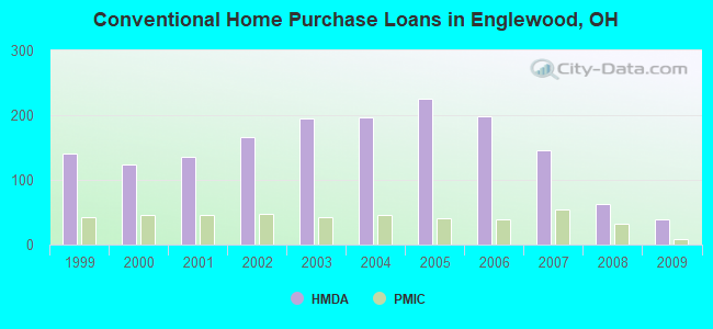
12 (See the full list of FAA Registered Aircraft in Englewood)| Home Mortgage Disclosure Act Aggregated Statistics For Year 2009 (Based on 3 partial tracts) | ||||||||||
| A) FHA, FSA/RHS & VA Home Purchase Loans | B) Conventional Home Purchase Loans | C) Refinancings | D) Home Improvement Loans | F) Non-occupant Loans on < 5 Family Dwellings (A B C & D) | ||||||
|---|---|---|---|---|---|---|---|---|---|---|
| Number | Average Value | Number | Average Value | Number | Average Value | Number | Average Value | Number | Average Value | |
| LOANS ORIGINATED | 85 | $111,262 | 39 | $102,212 | 228 | $116,517 | 13 | $35,424 | 10 | $102,443 |
| APPLICATIONS APPROVED, NOT ACCEPTED | 4 | $109,388 | 1 | $135,710 | 20 | $122,968 | 2 | $8,680 | 1 | $58,960 |
| APPLICATIONS DENIED | 11 | $105,580 | 3 | $81,423 | 95 | $122,291 | 12 | $32,987 | 4 | $68,000 |
| APPLICATIONS WITHDRAWN | 3 | $112,603 | 2 | $82,720 | 49 | $127,815 | 1 | $120,450 | 0 | $0 |
| FILES CLOSED FOR INCOMPLETENESS | 1 | $126,500 | 1 | $31,970 | 8 | $105,469 | 0 | $0 | 0 | $0 |
Detailed HMDA statistics for the following Tracts: 1201.02 , 1251.01, 1251.02
| Private Mortgage Insurance Companies Aggregated Statistics For Year 2009 (Based on 3 partial tracts) | ||||
| A) Conventional Home Purchase Loans | B) Refinancings | |||
|---|---|---|---|---|
| Number | Average Value | Number | Average Value | |
| LOANS ORIGINATED | 8 | $110,032 | 8 | $121,835 |
| APPLICATIONS APPROVED, NOT ACCEPTED | 2 | $129,725 | 2 | $178,720 |
| APPLICATIONS DENIED | 1 | $169,060 | 0 | $0 |
| APPLICATIONS WITHDRAWN | 0 | $0 | 0 | $0 |
| FILES CLOSED FOR INCOMPLETENESS | 1 | $140,670 | 0 | $0 |
Detailed PMIC statistics for the following Tracts: 1201.02 , 1251.01, 1251.02
2002 - 2018 National Fire Incident Reporting System (NFIRS) incidents
- Fire incident types reported to NFIRS in Englewood, OH
- 34652.7%Structure Fires
- 19629.8%Outside Fires
- 10816.4%Mobile Property/Vehicle Fires
- 71.1%Other
 According to the data from the years 2002 - 2018 the average number of fire incidents per year is 39. The highest number of reported fire incidents - 74 took place in 2018, and the least - 9 in 2002. The data has a growing trend.
 When looking into fire subcategories, the most reports belonged to: Structure Fires (52.7%), and Outside Fires (29.8%).
Fire-safe hotels and motels in Englewood, Ohio:
- Best Western Plus Dayton Northwest, 20 Rockridge Rd, Englewood, Ohio 45322 , Phone: (937) 832-2222, Fax: (937) 832-3859
- America's Best Value Inn, 1212 S Main St, Englewood, Ohio 45322 , Phone: (937) 540-1001, Fax: (937) 540-1011
- Hampton Inn & Suites, 180 Rockridge Rd, Englewood, Ohio 45322 , Phone: (937) 832-3333, Fax: (937) 832-3939
| Most common first names in Englewood, OH among deceased individuals | ||
| Name | Count | Lived (average) |
|---|---|---|
| Mary | 121 | 81.7 years |
| Robert | 112 | 73.4 years |
| James | 90 | 70.7 years |
| John | 85 | 74.7 years |
| William | 80 | 72.8 years |
| Charles | 75 | 73.4 years |
| Dorothy | 63 | 78.2 years |
| Ruth | 58 | 81.9 years |
| Donald | 54 | 72.0 years |
| Helen | 50 | 79.1 years |
| Most common last names in Englewood, OH among deceased individuals | ||
| Last name | Count | Lived (average) |
|---|---|---|
| Smith | 53 | 76.2 years |
| Miller | 44 | 76.0 years |
| Johnson | 28 | 77.8 years |
| Jones | 25 | 81.2 years |
| Baker | 22 | 79.8 years |
| Wilson | 21 | 67.2 years |
| Moore | 20 | 77.7 years |
| Davis | 19 | 78.4 years |
| Williams | 18 | 71.1 years |
| Brown | 17 | 71.0 years |
- 72.1%Utility gas
- 25.8%Electricity
- 1.6%Bottled, tank, or LP gas
- 0.5%Wood
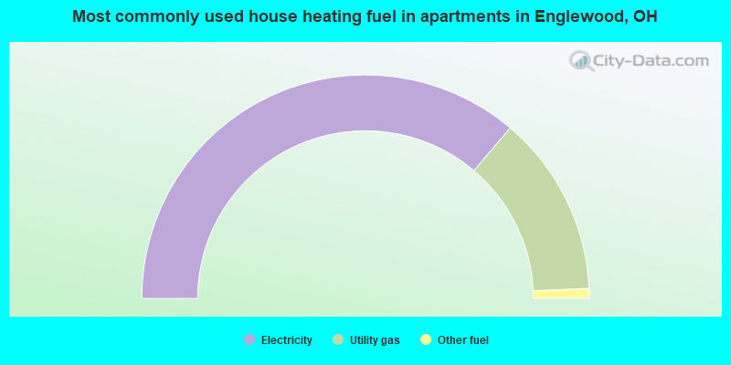
- 72.4%Electricity
- 26.2%Utility gas
- 1.4%Other fuel
Englewood compared to Ohio state average:
- Unemployed percentage significantly below state average.
- Hispanic race population percentage significantly below state average.
- Foreign-born population percentage below state average.
- Length of stay since moving in significantly above state average.

|
|
Total of 65 patent applications in 2008-2024.