Eolia, Kentucky
Submit your own pictures of this place and show them to the world
- OSM Map
- General Map
- Google Map
- MSN Map

| Males: 801 | |
| Females: 777 |
| Median resident age: | 36.4 years |
| Kentucky median age: | 35.9 years |
Zip code: 40826
| Eolia: | $30,506 |
| KY: | $59,341 |
Estimated per capita income in 2022: $18,336 (it was $9,214 in 2000)
Eolia CCD income, earnings, and wages data
Estimated median house or condo value in 2022: $69,916 (it was $34,100 in 2000)
| Eolia: | $69,916 |
| KY: | $196,300 |
Mean prices in 2022: all housing units: $114,459; detached houses: $128,463; townhouses or other attached units: $64,774; mobile homes: $82,859
Detailed information about poverty and poor residents in Eolia, KY


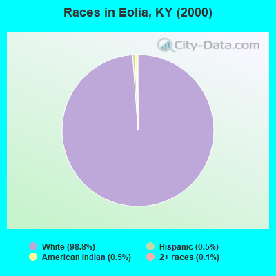
- 1,64298.8%White alone
- 80.5%American Indian alone
- 90.5%Hispanic
- 20.1%Two or more races
- 10.06%Other race alone
Races in Eolia detailed stats: ancestries, foreign born residents, place of birth
According to our research of Kentucky and other state lists, there were 2 registered sex offenders living in Eolia, Kentucky as of April 19, 2024.
The ratio of all residents to sex offenders in Eolia is 789 to 1.
The ratio of registered sex offenders to all residents in this city is lower than the state average.
 Recent articles from our blog. Our writers, many of them Ph.D. graduates or candidates, create easy-to-read articles on a wide variety of topics.

Current Local Time: EST time zone
Land area: 50.6 square miles.
Population density: 31 people per square mile (very low).

| Eolia CCD: | 0.7% ($234) |
| Kentucky: | 0.8% ($610) |
Nearest city with pop. 50,000+: Johnson City, TN  (55.0 miles , pop. 55,469).
Nearest city with pop. 200,000+: Fayette, KY (113.8 miles , pop. 260,512).
Nearest city with pop. 1,000,000+: Chicago, IL (420.9 miles , pop. 2,896,016).
Nearest cities:
), ), Latitude: 37.04 N, Longitude: 82.84 W
Area code commonly used in this area: 606

| Here: | 5.9% |
| Kentucky: | 3.8% |
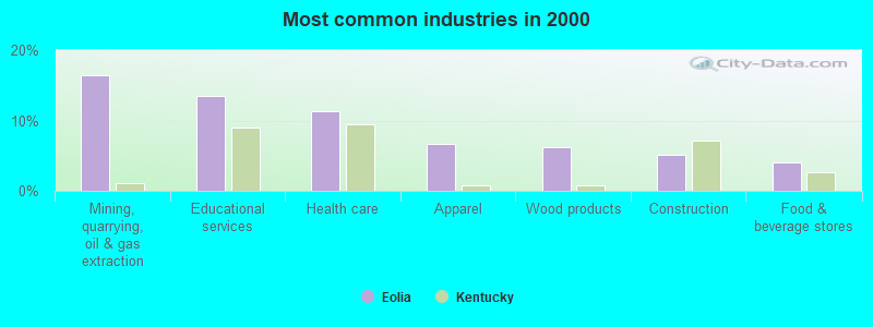
- Mining, quarrying, oil & gas extraction (16.4%)
- Educational services (13.6%)
- Health care (11.3%)
- Apparel (6.6%)
- Wood products (6.1%)
- Construction (5.1%)
- Food & beverage stores (4.1%)
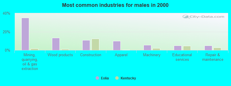
- Mining, quarrying, oil & gas extraction (35.2%)
- Wood products (13.2%)
- Construction (11.0%)
- Apparel (9.9%)
- Machinery (5.5%)
- Educational services (4.9%)
- Repair & maintenance (4.9%)
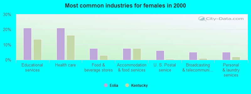
- Educational services (21.1%)
- Health care (21.1%)
- Food & beverage stores (7.7%)
- Accommodation & food services (7.7%)
- U. S. Postal service (6.2%)
- Broadcasting & telecommunications (5.3%)
- Personal & laundry services (5.3%)

- Textile, apparel, and furnishings workers (7.9%)
- Other management occupations, except farmers and farm managers (6.9%)
- Other sales and related occupations, including supervisors (5.6%)
- Supervisors, construction and extraction workers (5.4%)
- Cooks and food preparation workers (4.9%)
- Preschool, kindergarten, elementary, and middle school teachers (4.6%)
- Vehicle and mobile equipment mechanics, installers, and repairers (4.6%)

- Supervisors, construction and extraction workers (11.5%)
- Vehicle and mobile equipment mechanics, installers, and repairers (9.9%)
- Textile, apparel, and furnishings workers (9.9%)
- Other material moving workers, except laborers (9.3%)
- Extraction workers (8.8%)
- Woodworkers (8.2%)
- Driver/sales workers and truck drivers (7.7%)

- Other sales and related occupations, including supervisors (10.5%)
- Cooks and food preparation workers (9.1%)
- Preschool, kindergarten, elementary, and middle school teachers (8.6%)
- Other management occupations, except farmers and farm managers (7.7%)
- Other teachers, instructors, education, training, and library occupations (7.2%)
- Health technologists and technicians (6.7%)
- Textile, apparel, and furnishings workers (6.2%)
Average climate in Eolia, Kentucky
Based on data reported by over 4,000 weather stations


Tornado activity:
Eolia-area historical tornado activity is significantly below Kentucky state average. It is 73% smaller than the overall U.S. average.
On 5/18/1995, a category F2 (max. wind speeds 113-157 mph) tornado 22.5 miles away from the Eolia place center caused between $50,000 and $500,000 in damages.
On 4/4/1974, a category F3 (max. wind speeds 158-206 mph) tornado 52.4 miles away from the place center killed one person and injured 4 people and caused between $50,000 and $500,000 in damages.
Earthquake activity:
Eolia-area historical earthquake activity is significantly above Kentucky state average. It is 34% greater than the overall U.S. average.On 7/27/1980 at 18:52:21, a magnitude 5.2 (5.1 MB, 4.7 MS, 5.0 UK, 5.2 UK, Class: Moderate, Intensity: VI - VII) earthquake occurred 100.9 miles away from Eolia center
On 8/9/2020 at 12:07:37, a magnitude 5.1 (5.1 MW, Depth: 4.7 mi) earthquake occurred 104.2 miles away from the city center
On 8/23/2011 at 17:51:04, a magnitude 5.8 (5.8 MW, Depth: 3.7 mi) earthquake occurred 275.8 miles away from Eolia center
On 11/30/1973 at 07:48:41, a magnitude 4.7 (4.7 MB, 4.6 ML, Class: Light, Intensity: IV - V) earthquake occurred 106.0 miles away from the city center
On 9/7/1988 at 02:28:09, a magnitude 4.6 (4.5 MB, 4.6 LG) earthquake occurred 95.4 miles away from the city center
On 11/10/2012 at 17:08:14, a magnitude 4.2 (4.2 MW, Depth: 10.6 mi) earthquake occurred 13.8 miles away from the city center
Magnitude types: regional Lg-wave magnitude (LG), body-wave magnitude (MB), local magnitude (ML), surface-wave magnitude (MS), moment magnitude (MW)
Natural disasters:
The number of natural disasters in Letcher County (30) is a lot greater than the US average (15).Major Disasters (Presidential) Declared: 25
Emergencies Declared: 2
Causes of natural disasters: Floods: 23, Storms: 19, Mudslides: 9, Tornadoes: 7, Landslides: 6, Winter Storms: 4, Winds: 3, Snows: 2, Snowstorms: 2, Blizzard: 1, Flash Flood: 1, Freeze: 1, Heavy Rain: 1, Hurricane: 1, Snowfall: 1, Other: 1 (Note: some incidents may be assigned to more than one category).
Hospitals and medical centers near Eolia:
- LETCHER MANOR (Nursing Home, about 6 miles away; WHITESBURG, KY)
- WELLMONT LONESOME PINE HOSPITAL Acute Care Hospitals (about 12 miles away; BIG STONE GAP, VA)
- HERITAGE HALL BIG STONE GAP (Nursing Home, about 13 miles away; BIG STONE GAP, VA)
- HERITAGE HALL HEALTH CARE II (Nursing Home, about 13 miles away; BIG STONE GAP, VA)
- NORTON COMMUNITY HOSPITAL Acute Care Hospitals (about 14 miles away; NORTON, VA)
- HOSPICE AND PALLIATIVE CARE OF VIRGINIA (Hospital, about 14 miles away; NORTON, VA)
- BMA - MOUNTAIN EMPIRE (Dialysis Facility, about 14 miles away; NORTON, VA)
Colleges/universities with over 2000 students nearest to Eolia:
- Southeast Kentucky Community and Technical College (about 10 miles; Cumberland, KY; Full-time enrollment: 2,196)
- Hazard Community and Technical College (about 23 miles; Hazard, KY; FT enrollment: 2,087)
- Northeast State Community College (about 45 miles; Blountville, TN; FT enrollment: 4,480)
- Big Sandy Community and Technical College (about 46 miles; Prestonsburg, KY; FT enrollment: 2,660)
- King University (about 50 miles; Bristol, TN; FT enrollment: 2,472)
- Lincoln Memorial University (about 56 miles; Harrogate, TN; FT enrollment: 3,706)
- East Tennessee State University (about 58 miles; Johnson City, TN; FT enrollment: 12,774)
Public elementary/middle school in Eolia:
- ARLIE BOGGS ELEMENTARY SCHOOL (Students: 146, Location: 1099 HWY 806, Grades: KG-8)
Points of interest:
Notable locations in Eolia: Cumberland River Volunteer Fire Department Station 2 (A), Cumberland River Volunteer Fire Department (B). Display/hide their locations on the map
Church in Eolia: Eolia Church (A). Display/hide its location on the map
Cemeteries: Boggs Cemetery (1), Maggard Cemetery (2), Parsons Cemetery (3), Sturgill Cemetery (4), Roberts Branch Cemetery (5). Display/hide their locations on the map
Streams, rivers, and creeks: Colliers Creek (A), South Fork Collier Creek (B), Andy Branch (C), Bad Branch (D), Barlow Branch (E), Bee Branch (F), Brown Branch (G), Craiger Branch (H), Coal Branch (I). Display/hide their locations on the map
Park in Eolia: Hensley-Pine Mountain Wildlife Management Area (1). Display/hide its location on the map
| This place: | 2.6 people |
| Kentucky: | 2.5 people |
| This place: | 77.6% |
| Whole state: | 66.9% |
| This place: | 4.4% |
| Whole state: | 6.4% |
Likely homosexual households (counted as self-reported same-sex unmarried-partner households)
- Lesbian couples: 0.3% of all households
- Gay men: 0.5% of all households
| This place: | 27.2% |
| Whole state: | 15.8% |
| This place: | 16.7% |
| Whole state: | 6.6% |
For population 15 years and over in Eolia:
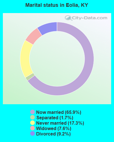
- Never married: 17.3%
- Now married: 65.9%
- Separated: 1.7%
- Widowed: 7.6%
- Divorced: 9.2%
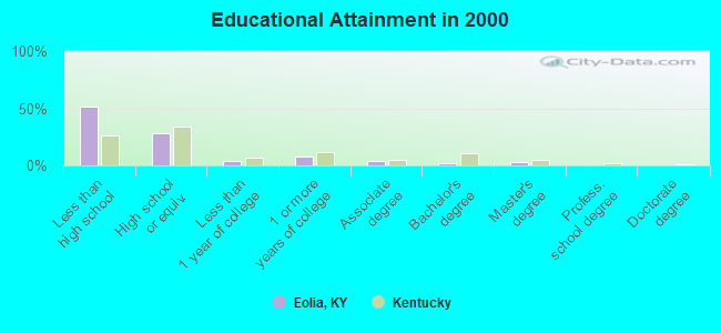
For population 25 years and over in Eolia:
- High school or higher: 48.5%
- Bachelor's degree or higher: 4.8%
- Graduate or professional degree: 2.5%
- Unemployed: 18.4%
- Mean travel time to work (commute): 35.1 minutes
| Here: | 18.6 |
| Kentucky average: | 13.8 |
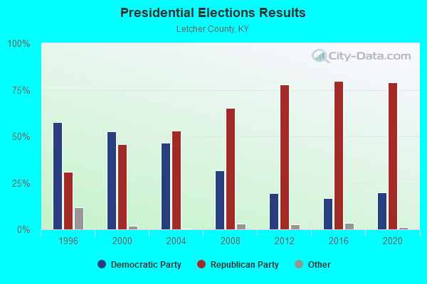
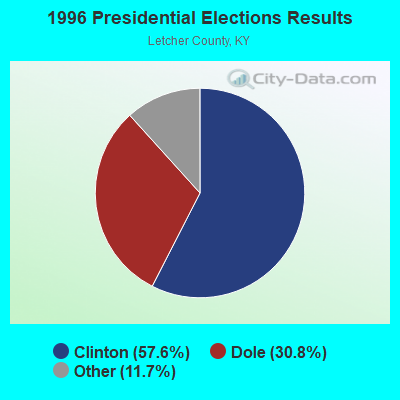
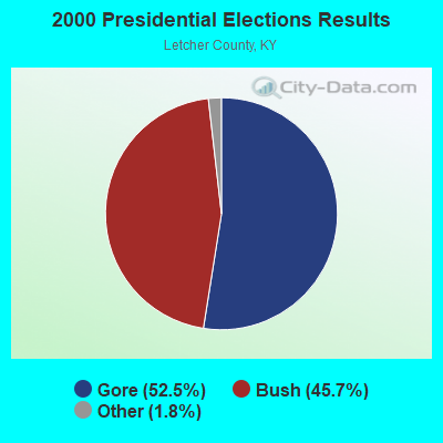

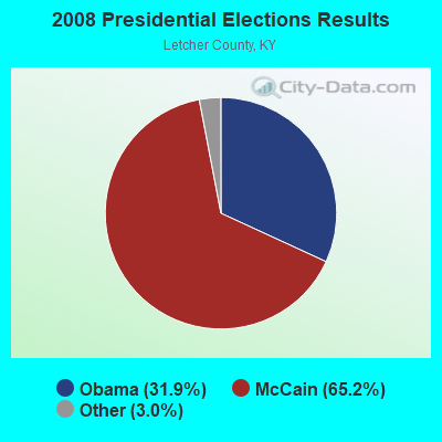


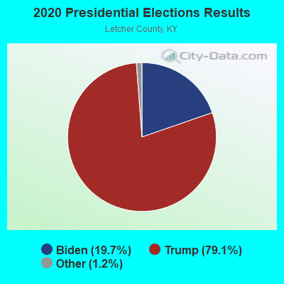
Graphs represent county-level data. Detailed 2008 Election Results
Religion statistics for Eolia, KY (based on Letcher County data)
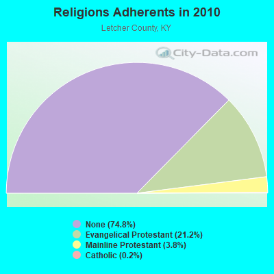
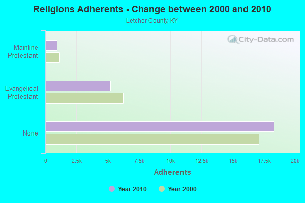
| Religion | Adherents | Congregations |
|---|---|---|
| Evangelical Protestant | 5,210 | 39 |
| Mainline Protestant | 929 | 7 |
| Catholic | 48 | 2 |
| Other | - | 1 |
| None | 18,332 | - |
Food Environment Statistics:
| This county: | 2.92 / 10,000 pop. |
| Kentucky: | 2.19 / 10,000 pop. |
| Letcher County: | 0.42 / 10,000 pop. |
| Kentucky: | 0.74 / 10,000 pop. |
| Letcher County: | 1.67 / 10,000 pop. |
| State: | 4.36 / 10,000 pop. |
| Here: | 1.25 / 10,000 pop. |
| Kentucky: | 5.74 / 10,000 pop. |
| Here: | 14.6% |
| Kentucky: | 11.0% |
| Letcher County: | 36.9% |
| Kentucky: | 30.0% |
| Letcher County: | 19.5% |
| Kentucky: | 15.9% |
Strongest AM radio stations in Eolia:
- WTCW (920 AM; 4 kW; WHITESBURG, KY; Owner: T.C.W. BROADCASTING , INC.)
- WEZC (1480 AM; daytime; 5 kW; NEON, KY; Owner: JESUS COMMUNICATION ILNC.)
- WNVA (1350 AM; 5 kW; NORTON, VA; Owner: RADIO-WISE, INC.)
- WCPM (1280 AM; 1 kW; CUMBERLAND, KY; Owner: CUMBERLAND CITY BROADCASTING, INC.)
- WGOC (640 AM; 10 kW; BLOUNTVILLE, TN; Owner: CITADEL BROADCASTING COMPANY)
- WKVL (850 AM; daytime; 50 kW; KNOXVILLE, TN; Owner: HORNE RADIO, LLC)
- WZAP (690 AM; 10 kW; BRISTOL, VA; Owner: RAM COMMUNICATIONS, INC.)
- WLSI (900 AM; 5 kW; PIKEVILLE, KY; Owner: EAST KENTUCKY BROADCASTING CORPORATION)
- WKIC (1390 AM; 5 kW; HAZARD, KY)
- WFSR (970 AM; 5 kW; HARLAN, KY; Owner: EASTERN BROADCASTING COMPAY)
- WPWT (870 AM; daytime; 10 kW; COLONIAL HEIGHTS, TN; Owner: INFORMATION COMMUNICATIONS CORP.)
- WDIC (1430 AM; daytime; 5 kW; CLINCHCO, VA; Owner: DICKENSON COUNTY BROADCASTING CORP.)
- WFGW (1010 AM; 50 kW; BLACK MOUNTAIN, NC; Owner: BLUE RIDGE BROADCASTING CORP.)
Strongest FM radio stations in Eolia:
- WIFX-FM (94.3 FM; JENKINS, KY; Owner: LETCHER COUNTY BROADCASTING, INC)
- WXKQ-FM (103.9 FM; WHITESBURG, KY; Owner: T.C.W. BROADCASTING , INC.)
- WMMT (88.7 FM; WHITESBURG, KY; Owner: APPALSHOP, INCORPORATED)
- WSEH (102.7 FM; CUMBERLAND, KY; Owner: CUMBERLAND CITY BROADCASTING, INC.)
- WAXM (93.5 FM; BIG STONE GAP, VA; Owner: VALLEY BROADCASTING, INC.)
- W223AA (92.5 FM; BIG STONE GAP, VA; Owner: VALLEY BROADCASTING, INC.)
- WDXC (102.3 FM; POUND, VA; Owner: WDXC RADIO, INC.)
- WSGS (101.1 FM; HAZARD, KY; Owner: MOUNTAIN BROADCASTING SERVICE, INC.)
- WTFM (98.5 FM; KINGSPORT, TN; Owner: HOLSTON VALLEY BROADCASTING CORP.)
- WEKH (90.9 FM; HAZARD, KY; Owner: EASTERN KENTUCKY UNIVERSITY)
- WZQQ (97.9 FM; HYDEN, KY; Owner: LESLIE COUNTY BROADCASTING, INC.)
- WNVA-FM (106.3 FM; NORTON, VA; Owner: RADIO WISE, INC.)
- WJMD (104.7 FM; HAZARD, KY; Owner: HAZARD BROADCASTING SERVICES)
- WPKE-FM (103.1 FM; COAL RUN, KY; Owner: EAST KENTUCKY BROADCASTING CORP.)
- WISE-FM (90.5 FM; WISE, VA; Owner: UNIVERSITY OF VIRGINIA'S COLLEGE AT WISE)
- WTUK (105.1 FM; HARLAN, KY; Owner: EASTERN BROADCASTING COMPANY)
- WKCB-FM (107.1 FM; HINDMAN, KY; Owner: HINDMAN BROADCASTING CORPORATION)
- WHCB (91.5 FM; BRISTOL, TN; Owner: APPALACHIAN EDUC. COMMUNICATION CORP)
- WETS-FM (89.5 FM; JOHNSON CITY, TN; Owner: EAST TENNESSEE STATE UNIVERSITY)
- WRZK (95.9 FM; COLONIAL HEIGHTS, TN; Owner: MURRAY COMMUNICATIONS)
TV broadcast stations around Eolia:
- W24BT (Channel 24; TALBERT, KY; Owner: MS COMMUNICATIONS, LLC)
- WYMT-TV (Channel 57; HAZARD, KY; Owner: WYMT LICENSEE CORP.)
- W31BU (Channel 31; TALBERT, KY; Owner: MS COMMUNICATIONS, LLC)
- W53BQ (Channel 53; TALBERT, KY; Owner: MS COMMUNICATIONS, LLC)
- W69ED (Channel 69; TALBERT, KY; Owner: MS COMMUNICATIONS, LLC)
- WKHA (Channel 35; HAZARD, KY; Owner: KENTUCKY AUTHORITY FOR EDUCATIONAL TV)
- W26BK (Channel 26; TALBERT, KY; Owner: MS COMMUNICATIONS, LLC)
- WAPM-CA (Channel 9; LYNCH/BENHAM, KY; Owner: HOLSTON VALLEY BROADCASTING CORPORATION)
- WSBN-TV (Channel 47; NORTON, VA; Owner: BLUE RIDGE PUBLIC TELEVISION, INC.)
Eolia fatal accident list:
FCC Registered Microwave Towers:
1- 13-10 BRIGHT, Bright Road (Lat: 37.076944 Lon: -82.808333), Type: Tower, Structure height: 29 m, Call Sign: WQHB871,
Assigned Frequencies: 6556.25 MHz, Grant Date: 04/29/2017, Expiration Date: 06/22/2027, Certifier: William F Hays, Registrant: Kentucky Emergency Warning System, 100 Minuteman Parkway, Building# 101, Frankfort, KY 40601, Phone: (502) 564-5397, Fax: (502) 564-6726, Email:
FCC Registered Amateur Radio Licenses:
4- Call Sign: KC4EZX, Grant Date: 05/03/1988, Expiration Date: 05/03/1998, Cancellation Date: 05/04/2000, Registrant: Wilma E Carter, Hc67 Box 2010, Eolia, KY 40826
- Call Sign: KC4TAJ, Licensee ID: L00313465, Grant Date: 03/23/2011, Expiration Date: 04/09/2021, Cancellation Date: 04/11/2023, Certifier: George A Blair, Registrant: George A Blair, 24 Angler Rd, Eolia, KY 40826
- Call Sign: N4SRO, Licensee ID: L01331676, Grant Date: 11/13/2017, Expiration Date: 12/26/2027, Certifier: Clarence T Carter, Registrant: Clarence T Carter, 466 Smith Creek, Eolia, KY 40826
- Call Sign: KO4YGJ, Licensee ID: L02533684, Grant Date: 03/07/2022, Expiration Date: 03/07/2032, Certifier: Myrel Short, Registrant: Myrel Short, 2652 Hwy 932, Eolia, KY 40826
Eolia compared to Kentucky state average:
- Median household income below state average.
- Median house value significantly below state average.
- Black race population percentage significantly below state average.
- Hispanic race population percentage significantly below state average.
- Median age below state average.
- Foreign-born population percentage significantly below state average.
- Renting percentage below state average.
- Length of stay since moving in significantly above state average.
- Number of rooms per house significantly below state average.
- House age significantly below state average.
- Number of college students below state average.
- Percentage of population with a bachelor's degree or higher significantly below state average.