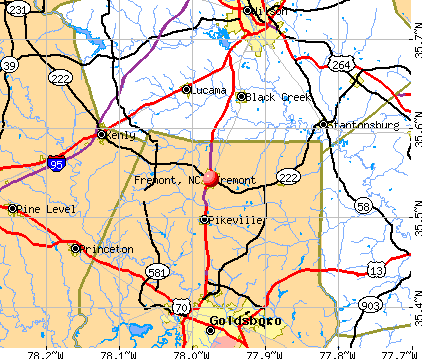
Fremont, North Carolina
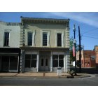
Fremont: Available Fremont Historic Buildings circa 1900-contact Kerry at City Hall (919) 242-6234
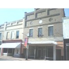
Fremont: Available Fremont Historic Buildings circa 1900-contact Kerry at City Hall (919) 242-6234
Fremont: Dear City-Data.com Please remove the photo that I watermarked with my website name (beatnikkenny.com) Please feel free to replace it with this attached version, that I have cropped to eliminate the website. I am not concerned with the others that I sent that are now posted. Many thanks Ken
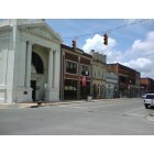
Fremont: Available Fremont Historic Buildings circa 1900-contact Kerry at City Hall (919) 242-6234

Fremont: Available Fremont Historic Buildings circa 1900-contact Kerry at City Hall (919) 242-6234
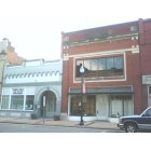
Fremont: Available Fremont Historic Buildings circa 1900-contact Kerry at City Hall (919) 242-6234
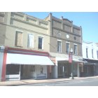
Fremont: Available Fremont Historic Buildings circa 1900-contact Kerry at City Hall (919) 242-6234
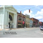
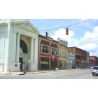
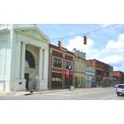
Fremont: Part of Downtown Fremont NC. Buildings are circa 1900, in foreground is BB&T Bank (c) Beatnik Kenny.com ALL RIGHTS RESERVED.
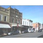
Fremont: Available Fremont Historic Buildings circa 1900-contact Kerry at City Hall (919) 242-6234
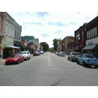
Fremont: Available Fremont Historic Buildings circa 1900-contact Kerry at City Hall (919) 242-6234
Fremont: please read email sent to: errors@city-data.com, legal@city-data.com, others@city-data.com
- see
15
more - add
your


Submit your own pictures of this town and show them to the world
- OSM Map
- General Map
- Google Map
- MSN Map
Population change since 2000: -18.7%
 |
| Males: 531 | |
| Females: 659 |
| Median resident age: | 46.6 years |
| North Carolina median age: | 39.2 years |
Zip codes: 27830.
| Fremont: | $45,249 |
| NC: | $67,481 |
Estimated per capita income in 2022: $23,779 (it was $16,892 in 2000)
Fremont town income, earnings, and wages data
Estimated median house or condo value in 2022: $114,065 (it was $60,300 in 2000)
| Fremont: | $114,065 |
| NC: | $280,600 |
Mean prices in 2022: all housing units: $135,873; detached houses: $140,713; mobile homes: $59,620
Median gross rent in 2022: $801.
(12.0% for White Non-Hispanic residents, 46.7% for Black residents, 50.0% for Hispanic or Latino residents, 78.7% for other race residents, 55.3% for two or more races residents)
Detailed information about poverty and poor residents in Fremont, NC

Compare current foreclosures near Fremont, NC:
| Photo | Address | Area | Beds / Baths | Price | Details |
|---|---|---|---|---|---|

|
#1
Davis Mill Rd
Fremont, NC 27830
|
2,732 sq. feet
|
3 baths 3 beds |
show details | |

|
#2
N Wilson St
Fremont, NC 27830
|
2,012 sq. feet
|
1 baths 3 beds |
show details | |

|
#3
Turner Swamp Rd
Fremont, NC 27830
|
1,836 sq. feet
|
2 baths 3 beds |
show details | |

|
#4
Aycock Dairy Farm Rd
Fremont, NC 27830
|
- sq. feet
|
- baths - beds |
show details | |

|
#5
Jesse Jackson St
La Grange, NC 28551
|
1,624 sq. feet
|
2 baths 3 beds |
$210,000
|
show details |

|
#6
Eli Olive Rd
Smithfield, NC 27577
|
1,991 sq. feet
|
2 baths 3 beds |
show details | |

|
#7
Mewborn Church Rd
Snow Hill, NC 28580
|
1,792 sq. feet
|
2 baths 4 beds |
show details | |

|
#8
Nc Hwy 91 S
Walstonburg, NC 27888
|
1,412 sq. feet
|
2 baths 3 beds |
show details | |

|
#9
Sauls St SW
Wilson, NC 27893
|
1,236 sq. feet
|
1 baths 2 beds |
show details | |

|
#10
Woodside Dr W
Wilson, NC 27893
|
1,488 sq. feet
|
2 baths 3 beds |
show details |
| Photo | Address | Area | Beds / Baths | Price | Details |
|---|---|---|---|---|---|

|
#11
Forrest Rd W
Wilson, NC 27893
|
1,053 sq. feet
|
1 baths 3 beds |
show details | |

|
#12
Carolina St E
Wilson, NC 27893
|
850 sq. feet
|
1 baths 2 beds |
show details | |

|
#13
Lauren Ln
Princeton, NC 27569
|
2,016 sq. feet
|
2 baths 3 beds |
show details | |

|
#14
Boykin Rd
Sims, NC 27880
|
1,192 sq. feet
|
1 baths 3 beds |
show details | |

|
#15
Village Dr W
Wilson, NC 27893
|
1,297 sq. feet
|
2 baths 3 beds |
show details | |

|
#16
Glenhaven Ln
Goldsboro, NC 27530
|
2,026 sq. feet
|
2 baths 3 beds |
show details | |

|
#17
Oakdale Dr W
Wilson, NC 27893
|
1,774 sq. feet
|
2 baths 3 beds |
show details | |

|
#18
Tammy Ln
Wilson, NC 27893
|
1,890 sq. feet
|
2 baths 4 beds |
show details | |

|
#19
Trinity Dr W
Wilson, NC 27893
|
1,605 sq. feet
|
3 baths 4 beds |
show details | |

|
#20
Merck Rd W
Wilson, NC 27893
|
1,470 sq. feet
|
2 baths 3 beds |
show details |
| Photo | Address | Area | Beds / Baths | Price | Details |
|---|---|---|---|---|---|

|
#21
Kensington Ave NW
Wilson, NC 27896
|
2,417 sq. feet
|
2 baths 3 beds |
show details | |

|
#22
Vance St N
Wilson, NC 27893
|
2,043 sq. feet
|
2 baths 4 beds |
show details | |

|
#23
Greenbriar Ct NW
Wilson, NC 27896
|
2,660 sq. feet
|
2 baths 4 beds |
show details | |

|
#24
Lisa Dr
Princeton, NC 27569
|
1,308 sq. feet
|
2 baths 3 beds |
show details | |

|
#25
Gold St N
Wilson, NC 27893
|
1,969 sq. feet
|
2 baths 3 beds |
show details | |

|
#26
Ricks Ct E
Wilson, NC 27893
|
1,508 sq. feet
|
2 baths 3 beds |
show details | |

|
#27
Thurston Dr W
Wilson, NC 27893
|
1,016 sq. feet
|
1 baths 2 beds |
show details | |

|
#28
Fitch Dr E
Wilson, NC 27893
|
1,500 sq. feet
|
2 baths 3 beds |
show details | |

|
#29
E Elm St
Goldsboro, NC 27530
|
1,155 sq. feet
|
1 baths 3 beds |
show details | |

|
#30
Whitfield Dr
Goldsboro, NC 27530
|
1,308 sq. feet
|
1 baths 3 beds |
show details |
| Photo | Address | Area | Beds / Baths | Price | Details |
|---|---|---|---|---|---|

|
#31
Brame Rd
Kenly, NC 27542
|
1,391 sq. feet
|
2 baths 3 beds |
show details | |

|
#32
E Walnut St
Goldsboro, NC 27530
|
2,278 sq. feet
|
2 baths 2 beds |
show details | |

|
#33
S Marion Dr
Goldsboro, NC 27534
|
1,691 sq. feet
|
2 baths 3 beds |
show details | |

|
#34
Bear Creek Rd
Goldsboro, NC 27534
|
1,877 sq. feet
|
2 baths 3 beds |
show details | |

|
#35
Randall Ln
Goldsboro, NC 27534
|
1,255 sq. feet
|
1 baths 3 beds |
show details | |

|
#36
Randall Ln
Goldsboro, NC 27534
|
1,512 sq. feet
|
2 baths 3 beds |
show details | |

|
#37
Meadow St S
Wilson, NC 27893
|
1,536 sq. feet
|
2 baths 3 beds |
show details | |

|
#38
Beech St
Goldsboro, NC 27530
|
1,404 sq. feet
|
1 baths 3 beds |
show details | |

|
#39
Holly Trl
Wilson, NC 27893
|
1,436 sq. feet
|
1 baths 3 beds |
show details | |

|
#40
Bayleaf Dr
Goldsboro, NC 27534
|
2,248 sq. feet
|
2 baths 3 beds |
show details |
| Photo | Address | Area | Beds / Baths | Price | Details |
|---|---|---|---|---|---|

|
#41
Sauls St SW
Wilson, NC 27893
|
1,263 sq. feet
|
1 baths 3 beds |
show details | |

|
#42
Judy Pl
Goldsboro, NC 27530
|
1,200 sq. feet
|
2 baths 3 beds |
show details | |

|
#43
Herbert St
Goldsboro, NC 27530
|
1,234 sq. feet
|
1 baths 3 beds |
show details | |

|
#44
Lafayette Dr NW
Wilson, NC 27893
|
3,185 sq. feet
|
2 baths 3 beds |
show details | |

|
#45
S Best St
Goldsboro, NC 27530
|
2,145 sq. feet
|
2 baths 3 beds |
show details | |

|
#46
Delano Ave SW
Wilson, NC 27893
|
912 sq. feet
|
1 baths 2 beds |
show details | |

|
#47
Brentwood Dr N
Wilson, NC 27893
|
1,887 sq. feet
|
2 baths 3 beds |
show details | |

|
#48
Pearson St N
Wilson, NC 27893
|
1,436 sq. feet
|
1 baths 3 beds |
show details | |

|
#49
Crockers Nub Rd
Middlesex, NC 27557
|
1,346 sq. feet
|
1 baths 3 beds |
show details | |

|
Check over 1 million property listings on Foreclosure.com!
|
browse all offers | |||


- 50253.8%White alone
- 27229.2%Black alone
- 828.8%Two or more races
- 788.4%Hispanic
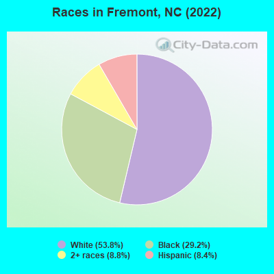
Races in Fremont detailed stats: ancestries, foreign born residents, place of birth
According to our research of North Carolina and other state lists, there were 7 registered sex offenders living in Fremont, North Carolina as of April 19, 2024.
The ratio of all residents to sex offenders in Fremont is 154 to 1.
Full-time law enforcement employees in 2021, including police officers: 4 (4 officers - 3 male; 1 female).
| Officers per 1,000 residents here: | 3.17 |
| North Carolina average: | 2.27 |
 Recent articles from our blog. Our writers, many of them Ph.D. graduates or candidates, create easy-to-read articles on a wide variety of topics.


 | Looks like Sheetz has a new competitor | Buc-ee’s coming to Orange County (312 replies) |
| Time to start watching Dorian (390 replies) |
| The Official Triangle Random Thoughts Thread (5806 replies) |
| Raleigh and Durham Ranked as NC's Least Stressed Cities (37 replies) |
| New interstate proposed for Wilkesboro (8 replies) |
| Road Construction/Projects in Coastal NC (429 replies) |
Latest news from Fremont, NC collected exclusively by city-data.com from local newspapers, TV, and radio stations
Ancestries: English (15.3%), Irish (5.9%), American (5.4%), Polish (3.4%), Turkish (2.5%), Jordanian (2.3%).
Current Local Time: EST time zone
Elevation: 153 feet
Land area: 1.36 square miles.
Population density: 874 people per square mile (low).

61 residents are foreign born (3.9% Latin America, 1.7% Asia).
| This town: | 6.5% |
| North Carolina: | 8.3% |
Median real estate property taxes paid for housing units with mortgages in 2022: $1,594 (1.0%)
Median real estate property taxes paid for housing units with no mortgage in 2022: $1,018 (1.1%)
Nearest city with pop. 50,000+: Rocky Mount, NC  (30.0 miles , pop. 55,893).
Nearest city with pop. 200,000+: Raleigh, NC (42.2 miles , pop. 276,093).
Nearest city with pop. 1,000,000+: Philadelphia, PA (344.8 miles , pop. 1,517,550).
Nearest cities:
), ), ), ), )Latitude: 35.54 N, Longitude: 77.97 W
Area code: 919

| Here: | 3.5% |
| North Carolina: | 3.2% |
- Construction (8.6%)
- Health care (8.3%)
- Accommodation & food services (6.7%)
- Educational services (5.8%)
- Apparel (4.3%)
- Department & other general merchandise stores (4.3%)
- Plastics & rubber products (4.3%)
- Construction (16.7%)
- Plastics & rubber products (8.6%)
- Agriculture, forestry, fishing & hunting (6.3%)
- Food & beverage stores (4.8%)
- Public administration (4.5%)
- Administrative & support & waste management services (4.1%)
- Professional, scientific, technical services (3.7%)
- Health care (15.7%)
- Accommodation & food services (9.8%)
- Educational services (9.4%)
- Department & other general merchandise stores (7.3%)
- Apparel (7.0%)
- Social assistance (6.6%)
- Miscellaneous manufacturing (4.9%)
- Other production occupations, including supervisors (10.4%)
- Building and grounds cleaning and maintenance occupations (5.4%)
- Laborers and material movers, hand (4.3%)
- Retail sales workers, except cashiers (4.1%)
- Textile, apparel, and furnishings workers (4.0%)
- Other sales and related occupations, including supervisors (3.6%)
- Construction traders workers except carpenters, electricians, painters, plumbers, and construction laborers (3.6%)
- Other production occupations, including supervisors (12.3%)
- Construction traders workers except carpenters, electricians, painters, plumbers, and construction laborers (7.4%)
- Driver/sales workers and truck drivers (7.1%)
- Building and grounds cleaning and maintenance occupations (5.9%)
- Other sales and related occupations, including supervisors (4.8%)
- Farmers and farm managers (4.5%)
- Other management occupations, except farmers and farm managers (3.7%)
- Other production occupations, including supervisors (8.7%)
- Laborers and material movers, hand (5.9%)
- Nursing, psychiatric, and home health aides (5.9%)
- Preschool, kindergarten, elementary, and middle school teachers (5.6%)
- Child care workers (5.6%)
- Retail sales workers, except cashiers (5.6%)
- Building and grounds cleaning and maintenance occupations (4.9%)
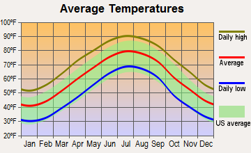
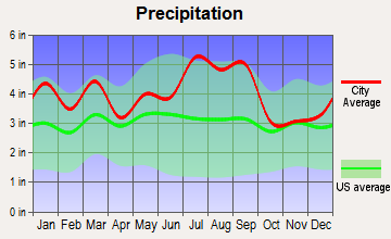
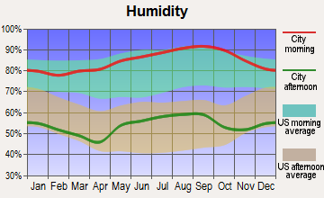
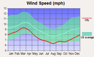
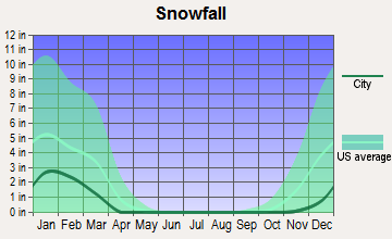
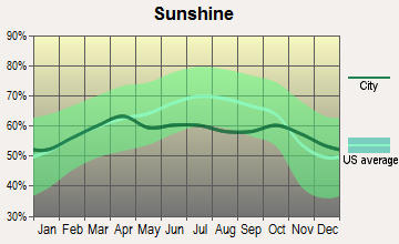
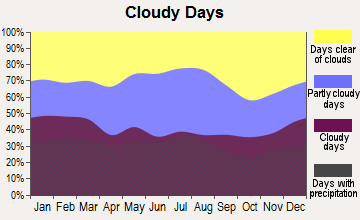
Average climate in Fremont, North Carolina
Based on data reported by over 4,000 weather stations
|
|


(lower is better)
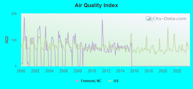
Air Quality Index (AQI) level in 2015 was 71.5. This is about average.
| City: | 71.5 |
| U.S.: | 72.6 |
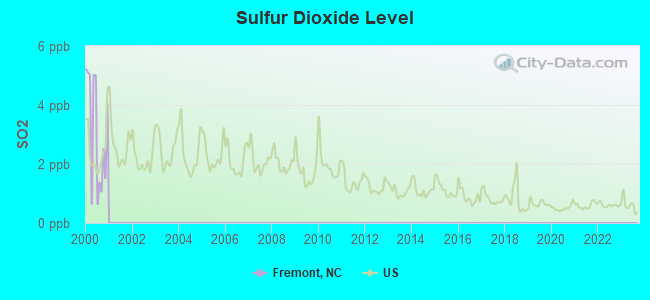
Sulfur Dioxide (SO2) [ppb] level in 2000 was 3.09. This is significantly worse than average. Closest monitor was 10.0 miles away from the city center.
| City: | 3.09 |
| U.S.: | 1.51 |

Ozone [ppb] level in 2007 was 35.7. This is about average. Closest monitor was 12.0 miles away from the city center.
| City: | 35.7 |
| U.S.: | 33.3 |
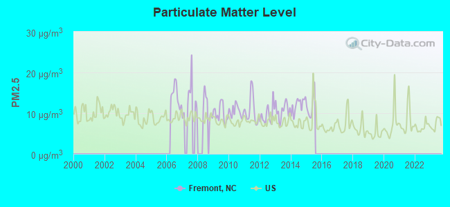
Particulate Matter (PM2.5) [µg/m3] level in 2015 was 11.9. This is significantly worse than average. Closest monitor was 12.1 miles away from the city center.
| City: | 11.9 |
| U.S.: | 8.1 |
Tornado activity:
Fremont-area historical tornado activity is slightly above North Carolina state average. It is 13% greater than the overall U.S. average.
On 3/28/1984, a category F4 (max. wind speeds 207-260 mph) tornado 18.4 miles away from the Fremont town center killed 16 people and injured 153 people and caused between $5,000,000 and $50,000,000 in damages.
On 3/28/1984, a category F4 tornado 19.1 miles away from the town center killed 3 people and injured 149 people and caused between $5,000,000 and $50,000,000 in damages.
Earthquake activity:
Fremont-area historical earthquake activity is significantly above North Carolina state average. It is 54% smaller than the overall U.S. average.On 8/23/2011 at 17:51:04, a magnitude 5.8 (5.8 MW, Depth: 3.7 mi, Class: Moderate, Intensity: VI - VII) earthquake occurred 163.7 miles away from the city center
On 8/9/2020 at 12:07:37, a magnitude 5.1 (5.1 MW, Depth: 4.7 mi) earthquake occurred 186.0 miles away from the city center
On 12/9/2003 at 20:59:14, a magnitude 4.5 (4.5 MB, 4.5 LG, Class: Light, Intensity: IV - V) earthquake occurred 141.4 miles away from the city center
On 12/9/2003 at 20:59:18, a magnitude 4.5 (4.5 ML, Depth: 6.2 mi) earthquake occurred 154.5 miles away from Fremont center
On 8/25/2011 at 05:07:52, a magnitude 4.5 (4.5 ML, Depth: 4.2 mi) earthquake occurred 166.3 miles away from Fremont center
On 11/22/1974 at 05:25:55, a magnitude 4.7 (4.7 MB) earthquake occurred 221.0 miles away from Fremont center
Magnitude types: regional Lg-wave magnitude (LG), body-wave magnitude (MB), local magnitude (ML), moment magnitude (MW)
Natural disasters:
The number of natural disasters in Wayne County (20) is greater than the US average (15).Major Disasters (Presidential) Declared: 10
Emergencies Declared: 6
Causes of natural disasters: Hurricanes: 13, Storms: 3, Tornadoes: 3, Floods: 2, Ice Storms: 2, Drought: 1, Other: 1 (Note: some incidents may be assigned to more than one category).

Hospitals and medical centers near Fremont:
- AIRPORT ROAD GROUP HOME (Hospital, about 7 miles away; GOLDSBORO, NC)
- NORWOOD AVENUE HOME (Hospital, about 10 miles away; GOLDSBORO, NC)
- WAYNE MEMORIAL HOSPITAL Acute Care Hospitals (about 10 miles away; GOLDSBORO, NC)
- HOME HEALTH AND HOSPICE CARE (Home Health Center, about 11 miles away; GOLDSBORO, NC)
- WILLOW CREEK NURSING AND REHABILITATION CENTER (Nursing Home, about 11 miles away; GOLDSBORO, NC)
- RAI CARE CENTERS GOLDSBORO (Dialysis Facility, about 11 miles away; GOLDSBORO, NC)
- GOLDSBORO SOUTH DIALYSIS (Dialysis Facility, about 11 miles away; GOLDSBORO, NC)
Amtrak stations near Fremont:
- 11 miles: GOLDSBORO (410 N. JOHN ST.) - Bus Station . Services: enclosed waiting area, public restrooms, public payphones, full-service food facilities, free short-term parking, free long-term parking, intercity bus service.
- 13 miles: WILSON (401 E. NASH ST.) . Services: ticket office, partially wheelchair accessible, enclosed waiting area, public restrooms, public payphones, free short-term parking, free long-term parking, call for taxi service, intercity bus service.
- 18 miles: SELMA-SMITHFIELD (SELMA, 401 E. RAILROAD AVE.) . Services: public payphones, free short-term parking, free long-term parking, call for taxi service.
Colleges/universities with over 2000 students nearest to Fremont:
- Wayne Community College (about 10 miles; Goldsboro, NC; Full-time enrollment: 3,174)
- Johnston Community College (about 21 miles; Smithfield, NC; FT enrollment: 3,657)
- Mount Olive College (about 24 miles; Mount Olive, NC; FT enrollment: 3,097)
- Nash Community College (about 31 miles; Rocky Mount, NC; FT enrollment: 2,520)
- Lenoir Community College (about 32 miles; Kinston, NC; FT enrollment: 2,555)
- Pitt Community College (about 32 miles; Winterville, NC; FT enrollment: 7,026)
- Edgecombe Community College (about 33 miles; Tarboro, NC; FT enrollment: 2,058)
Public elementary/middle schools in Fremont:
- FREMONT STARS ELEMENTARY (Location: 101 PINE STREET, Grades: PK-5)
- NORWAYNE MIDDLE (Location: 1394 NORWAYNE SCHOOL ROAD, Grades: 6-8)
Points of interest:
Notable location: Fremont Police Department (A). Display/hide its location on the map
Church in Fremont: New Bethel Church (A). Display/hide its location on the map
Cemetery: Elmwood Cemetery (1). Display/hide its location on the map
Birthplace of: Johnny Peacock - Baseball player.
| This town: | 2.3 people |
| North Carolina: | 2.5 people |
| This town: | 58.5% |
| Whole state: | 66.7% |
| This town: | 2.9% |
| Whole state: | 5.9% |
Likely homosexual households (counted as self-reported same-sex unmarried-partner households)
- Lesbian couples: 0.4% of all households
- Gay men: 0.0% of all households
48 people in nursing homes in 2000
2 people in homes for the mentally retarded in 2000
Banks with branches in Fremont (2011 data):
- The Heritage Bank: Fremont Branch at 100 Wilson Street, branch established on 1984/12/28. Info updated 2011/07/11: Bank assets: $265.5 mil, Deposits: $228.1 mil, headquarters in Lucama, NC, positive income, Commercial Lending Specialization, 13 total offices, Holding Company: Heritage Bancshares, Inc.
- Branch Banking and Trust Company: Fremont Main Branch at 126 East Main Street, branch established on 1938/01/31. Info updated 2010/03/29: Bank assets: $168,867.6 mil, Deposits: $127,549.5 mil, headquarters in Winston Salem, NC, positive income, Commercial Lending Specialization, 1793 total offices, Holding Company: Bb&T Corporation
For population 15 years and over in Fremont:
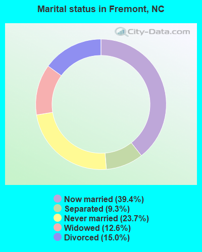
- Never married: 23.7%
- Now married: 39.4%
- Separated: 9.3%
- Widowed: 12.6%
- Divorced: 15.0%
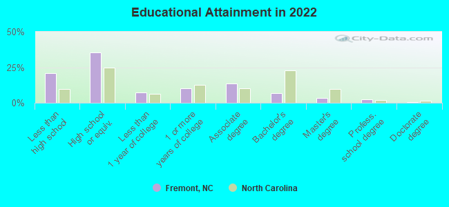
For population 25 years and over in Fremont:
- High school or higher: 80.9%
- Bachelor's degree or higher: 12.7%
- Graduate or professional degree: 5.0%
- Unemployed: 8.6%
- Mean travel time to work (commute): 23.8 minutes
| Here: | 11.0 |
| North Carolina average: | 11.7 |
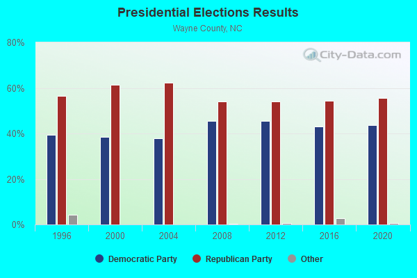
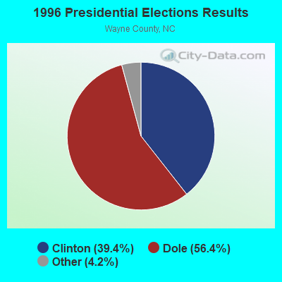
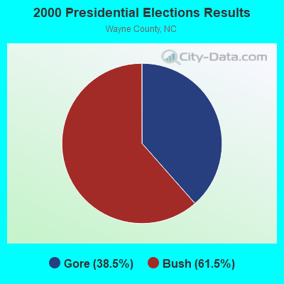
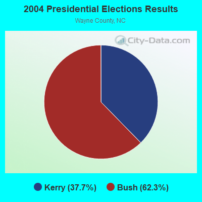
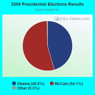
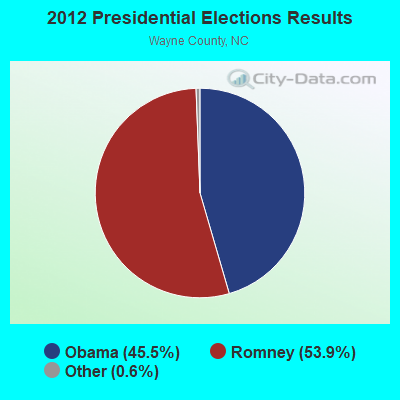
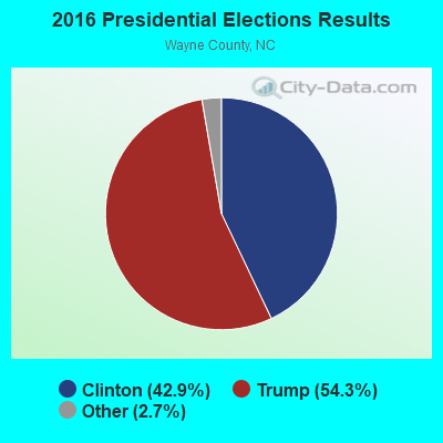
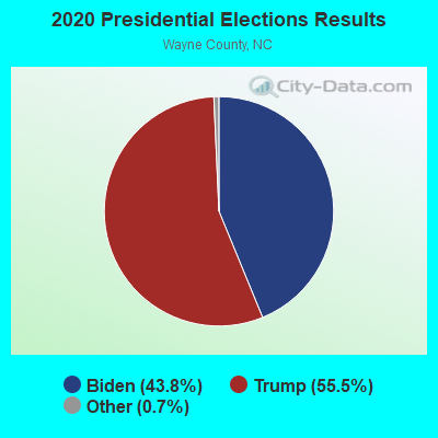
Graphs represent county-level data. Detailed 2008 Election Results
Religion statistics for Fremont, NC (based on Wayne County data)
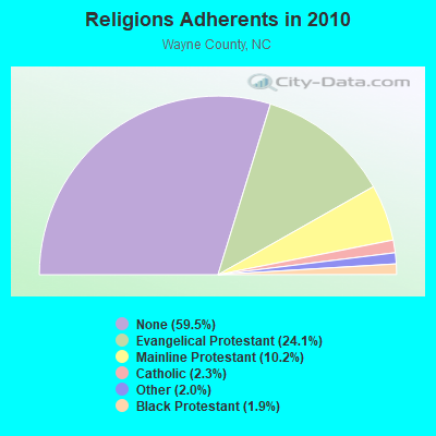
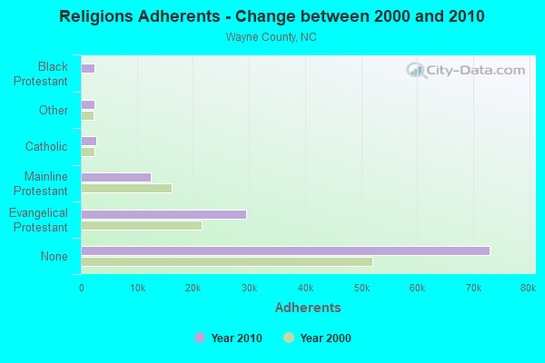
| Religion | Adherents | Congregations |
|---|---|---|
| Evangelical Protestant | 29,543 | 157 |
| Mainline Protestant | 12,482 | 64 |
| Catholic | 2,800 | 2 |
| Other | 2,438 | 10 |
| Black Protestant | 2,384 | 34 |
| None | 72,976 | - |
Food Environment Statistics:
| This county: | 1.94 / 10,000 pop. |
| North Carolina: | 2.05 / 10,000 pop. |
| Wayne County: | 0.18 / 10,000 pop. |
| North Carolina: | 0.14 / 10,000 pop. |
| Wayne County: | 0.97 / 10,000 pop. |
| State: | 0.92 / 10,000 pop. |
| Wayne County: | 5.38 / 10,000 pop. |
| North Carolina: | 4.75 / 10,000 pop. |
| Wayne County: | 6.61 / 10,000 pop. |
| State: | 7.57 / 10,000 pop. |
| Wayne County: | 10.4% |
| State: | 9.8% |
| Here: | 30.8% |
| State: | 28.3% |
| Wayne County: | 17.6% |
| North Carolina: | 15.6% |
Health and Nutrition:
| Fremont: | 46.6% |
| North Carolina: | 48.9% |
| This city: | 41.3% |
| North Carolina: | 46.1% |
| Fremont: | 29.7 |
| North Carolina: | 28.8 |
| This city: | 20.5% |
| State: | 20.7% |
| Fremont: | 14.6% |
| North Carolina: | 10.7% |
| Fremont: | 6.7 |
| North Carolina: | 6.8 |
| Fremont: | 36.3% |
| North Carolina: | 33.7% |
| Fremont: | 49.8% |
| North Carolina: | 55.8% |
| Fremont: | 77.9% |
| North Carolina: | 79.7% |
More about Health and Nutrition of Fremont, NC Residents
| Local government employment and payroll (March 2022) | |||||
| Function | Full-time employees | Monthly full-time payroll | Average yearly full-time wage | Part-time employees | Monthly part-time payroll |
|---|---|---|---|---|---|
| Other and Unallocable | 3 | $9,059 | $36,236 | 0 | $0 |
| Police Protection - Officers | 3 | $11,054 | $44,216 | 1 | $1,290 |
| Streets and Highways | 2 | $4,989 | $29,934 | 1 | $1,200 |
| Water Supply | 1 | $6,554 | $78,648 | 0 | $0 |
| Financial Administration | 1 | $4,256 | $51,072 | 0 | $0 |
| Electric Power | 1 | $4,871 | $58,452 | 1 | $943 |
| Sewerage | 1 | $3,955 | $47,460 | 0 | $0 |
| Solid Waste Management | 1 | $2,834 | $34,008 | 0 | $0 |
| Other Government Administration | 0 | $0 | 8 | $5,011 | |
| Fire - Other | 0 | $0 | 1 | $496 | |
| Totals for Government | 13 | $47,572 | $43,913 | 12 | $8,941 |
Fremont government finances - Expenditure in 2017 (per resident):
- Current Operations - Electric Utilities: $1,454,000 ($1221.85)
Sewerage: $667,000 ($560.50)
Water Utilities: $542,000 ($455.46)
Police Protection: $282,000 ($236.97)
Financial Administration: $236,000 ($198.32)
Regular Highways: $108,000 ($90.76)
Solid Waste Management: $77,000 ($64.71)
Local Fire Protection: $66,000 ($55.46)
Parks and Recreation: $4,000 ($3.36)
Miscellaneous Commercial Activities - Other: $3,000 ($2.52)
- General - Interest on Debt: $11,000 ($9.24)
- Other Capital Outlay - Police Protection: $38,000 ($31.93)
- Water Utilities - Interest on Debt: $33,000 ($27.73)
Fremont government finances - Revenue in 2017 (per resident):
- Charges - Sewerage: $720,000 ($605.04)
Solid Waste Management: $161,000 ($135.29)
Miscellaneous Commercial Activities: $8,000 ($6.72)
- Federal Intergovernmental - Water Utilities: $235,000 ($197.48)
Other: $25,000 ($21.01)
- Local Intergovernmental - Other: $18,000 ($15.13)
Housing and Community Development: $4,000 ($3.36)
- Miscellaneous - General Revenue - Other: $14,000 ($11.76)
Interest Earnings: $0 ($0.00)
- Revenue - Electric Utilities: $1,775,000 ($1491.60)
Water Utilities: $572,000 ($480.67)
- State Intergovernmental - General Local Government Support: $98,000 ($82.35)
Highways: $44,000 ($36.97)
- Tax - Property: $408,000 ($342.86)
General Sales and Gross Receipts: $162,000 ($136.13)
Other License: $1,000 ($0.84)
Fremont government finances - Debt in 2017 (per resident):
- Long Term Debt - Beginning Outstanding - Unspecified Public Purpose: $978,000 ($821.85)
Outstanding Unspecified Public Purpose: $889,000 ($747.06)
Retired Unspecified Public Purpose: $89,000 ($74.79)
7.19% of this county's 2021 resident taxpayers lived in other counties in 2020 ($44,417 average adjusted gross income)
| Here: | 7.19% |
| North Carolina average: | 8.85% |
0.28% of residents moved from foreign countries ($2,002 average AGI)
Wayne County: 0.28% North Carolina average: 0.04%
Top counties from which taxpayers relocated into this county between 2020 and 2021:
| from Johnston County, NC | |
| from Wake County, NC | |
| from Lenoir County, NC |
7.49% of this county's 2020 resident taxpayers moved to other counties in 2021 ($45,703 average adjusted gross income)
| Here: | 7.49% |
| North Carolina average: | 7.89% |
0.31% of residents moved to foreign countries ($2,272 average AGI)
Wayne County: 0.31% North Carolina average: 0.03%
Top counties to which taxpayers relocated from this county between 2020 and 2021:
| to Johnston County, NC | |
| to Wake County, NC | |
| to Lenoir County, NC |
Businesses in Fremont, NC
- Dunkin Donuts: 1
Strongest AM radio stations in Fremont:
- WGTM (590 AM; 5 kW; WILSON, NC; Owner: SPIRIT BROADCASTING, INC.)
- WPTF (680 AM; 50 kW; RALEIGH, NC; Owner: FIRST STATE COMMUNICATIONS)
- WGBR (1150 AM; 5 kW; GOLDSBORO, NC; Owner: NEW AGE COMMUNICATIONS, LTD.)
- WDJS (1430 AM; 10 kW; MOUNT OLIVE, NC; Owner: MOUNT OLIVE BROADCASTING CO.)
- WFTK (1030 AM; daytime; 50 kW; WAKE FOREST, NC; Owner: POSITIVE RADIO GROUP, INC.)
- WETC (540 AM; 8 kW; WENDELL-ZEBULON, NC; Owner: CAROLINA REGIONAL BROADCASTING CORPORATION)
- WMPM (1270 AM; 5 kW; SMITHFIELD, NC; Owner: CAROLINA BROADCASTING SERVICE, INC.)
- WNCT (1070 AM; 10 kW; GREENVILLE, NC; Owner: WNCT LICENSE LIMITED PARTNERSHIP)
- WFMC (730 AM; 1 kW; GOLDSBORO, NC; Owner: NEW AGE COMMUNICATIONS, INC)
- WRNS (960 AM; 5 kW; KINSTON, NC; Owner: NM LICENSING, LLC)
- WGHB (1250 AM; 5 kW; FARMVILLE, NC; Owner: CONNER MEDIA, INC.)
- WSSG (1300 AM; 1 kW; GOLDSBORO, NC)
- WCKB (780 AM; 7 kW; DUNN, NC; Owner: NORTH CAROLINA CENTRAL BROADCASTERS, INC.)
Strongest FM radio stations in Fremont:
- WTRG (100.7 FM; ROCKY MOUNT, NC; Owner: CAPSTAR TX LIMITED PARTNERSHIP)
- WYMY (96.9 FM; GOLDSBORO, NC; Owner: NEW AGE COMMUNICATIONS, LTD.)
- WRDU (106.1 FM; WILSON, NC; Owner: CAPSTAR TX LIMITED PARTNERSHIP)
- WKIX (102.3 FM; GOLDSBORO, NC; Owner: NEW AGE COMMUNICATIONS, INC.)
- WRNS-FM (95.1 FM; KINSTON, NC; Owner: NM LICENSING, LLC)
- WRAL (101.5 FM; RALEIGH, NC; Owner: WRAL-FM, INC.)
- WERO (93.3 FM; WASHINGTON, NC; Owner: NM LICENSING, LLC)
- WFXK (104.3 FM; TARBORO, NC; Owner: RADIO ONE LICENSES, LLC)
- WNCT-FM (107.9 FM; GREENVILLE, NC; Owner: WNCT LICENSE LIMITED PARTNERSHIP)
- W276AX (103.1 FM; PRINCETON, ETC., NC; Owner: GRACE CHRISTIAN SCHOOL)
- WKNS (90.3 FM; KINSTON, NC; Owner: CRAVEN COMMUNITY COLLEGE)
- WRQM (90.9 FM; ROCKY MOUNT, NC; Owner: BOARD OF TRUSTEES UNIVERSITY OF NC AT CHAPEL HILL)
- WQDR (94.7 FM; RALEIGH, NC; Owner: CAROLINA MEDIA GROUP, INC.)
- WRSV (92.1 FM; ROCKY MOUNT, NC; Owner: NORTHSTAR BROADCATING CORPORATION)
- WCPE (89.7 FM; RALEIGH, NC; Owner: EDUCATIONAL INFORMATION CORPORATION)
- WZUP (104.7 FM; ROSE HILL, NC; Owner: CONNER MEDIA CORPORATION)
- WBBB (96.1 FM; RALEIGH, NC; Owner: CAROLINA MEDIA GROUP, INC.)
- WAGO (88.7 FM; SNOW HILL, NC; Owner: PATHWAY CHRISTIAN ACADEMY, INC.)
- WSAY-FM (98.5 FM; ROCKY MOUNT, NC; Owner: FIRST MEDIA RADIO, LLC)
- W287AI (105.3 FM; GOLDSBORO, NC; Owner: BIBLE BROADCASTING NETWORK, INC.)
TV broadcast stations around Fremont:
- WRAY-TV (Channel 30; WILSON, NC; Owner: WRAY, INC.)
- WRAL-TV (Channel 5; RALEIGH, NC; Owner: CAPITOL BROADCASTING COMPANY, INC.)
- WTVD (Channel 11; DURHAM, NC; Owner: ABC, INC.)
- WITN-TV (Channel 7; WASHINGTON, NC; Owner: WITN LICENSEE CORP.)
- WNCN (Channel 17; GOLDSBORO, NC; Owner: OUTLET BROADCASTING, INC.)
- WNCT-TV (Channel 9; GREENVILLE, NC; Owner: MEDIA GENERAL COMMUNICATIONS, INC.)
- WUNK-TV (Channel 25; GREENVILLE, NC; Owner: UNIVERSITY OF NORTH CAROLINA)
- WLFL (Channel 22; RALEIGH, NC; Owner: WLFL LICENSEE, LLC)
- WRDC (Channel 28; DURHAM, NC; Owner: RALEIGH (WRDC-TV) LICENSEE, INC.)
- WHFL-LP (Channel 56; GOLDSBORO, NC; Owner: FREE LIFE MINISTRIES, INC.)
- WRPX (Channel 47; ROCKY MOUNT, NC; Owner: PAXSON RALEIGH LICENSE, INC.)
- WCTI-TV (Channel 12; NEW BERN, NC; Owner: EASTERN NORTH CAROLINA BROADCASTING CORPORATION)
- WNCR-LP (Channel 20; WILSON, NC; Owner: ON THE MAP, INC.)
- WRAZ (Channel 50; RALEIGH, NC; Owner: WRAZ-TV, INC.)
- WUNM-TV (Channel 19; JACKSONVILLE, NC; Owner: UNIVERSITY OF NORTH CAROLINA)
- W63CW (Channel 63; GOLDSBORO, NC; Owner: TRINITY BROADCASTING NETWORK)
- WUVC (Channel 40; FAYETTEVILLE, NC; Owner: CAPITAL BROADCASTING PARTNERS)
- WARZ-LP (Channel 34; SMITHFIELD/SELMA, NC; Owner: WATERS & BROCK COMMUNICATIONS, INC.)
- WYDO (Channel 14; GREENVILLE, NC; Owner: PIEDMONT TELEVISION OF EASTERN CAROLINA LICENSE LLC)
- W64AZ (Channel 64; KINSTON-GREENVILLE, NC; Owner: GOCOM TELEVISION, L.P.,)
Fremont fatal accident list:
Sep 2, 2007 06:26 AM, Rp-1353, Lat: 35.544675, Lon: -77.983758, Vehicles: 1, Persons: 1, Fatalities: 1, Drunk persons involved: 1
Sep 9, 1990 06:20 AM, Blank St, Vehicles: 1, Persons: 2, Fatalities: 1, Drunk persons involved: 1
Feb 4, 1988 01:30 PM, Pine&wayne, Vehicles: 2, Persons: 3, Fatalities: 1
Oct 14, 1978 03:15 AM, Vehicles: 1, Persons: 1, Fatalities: 1
- National Bridge Inventory (NBI) Statistics
- 21Number of bridges
- 328ft / 99.8mTotal length
- 101,830Total average daily traffic
- 21,391Total average daily truck traffic
- New bridges - historical statistics
- 11940-1949
- 11950-1959
- 11970-1979
- 21990-1999
- 142000-2009
- 22010-2019
FCC Registered Cell Phone Towers:
1 (See the full list of FCC Registered Cell Phone Towers in Fremont)FCC Registered Antenna Towers:
34 (See the full list of FCC Registered Antenna Towers)FCC Registered Broadcast Land Mobile Towers:
2- Nc Hwy 581 Int Cr 1347 At Watson Cross Roads (Lat: 35.558500 Lon: -78.076389), Call Sign: KAW477, Licensee ID: L00066193,
Assigned Frequencies: 154.130 MHz, Grant Date: 12/20/2001, Expiration Date: 12/20/2011, Cancellation Date: 02/25/2012, Registrant: Polly Watson Vfd, 100 S William St, Goldsboro, NC 27530, Phone: (919) 731-1416
- Us Hwy 117 N (Lat: 35.544611 Lon: -77.980278), Call Sign: KAW506, Licensee ID: L00066193,
Assigned Frequencies: 154.130 MHz, Grant Date: 03/26/2002, Expiration Date: 12/23/2011, Cancellation Date: 02/25/2012, Registrant: County Of Wayne, Box 227, Goldsboro, NC 27530, Phone: (919) 731-1416
FCC Registered Microwave Towers:
4- FREMONT, 862 Moye Rd (Lat: 35.552722 Lon: -77.958278), Type: Gtower, Structure height: 97.5 m, Overall height: 102.1 m, Call Sign: WPQT901,
Assigned Frequencies: 6197.24 MHz, Grant Date: 09/22/2020, Expiration Date: 10/18/2030, Certifier: Steven T Campbell, Registrant: Wilkinson Barker Knauer, LLP, 1800 M Street Nw, Suite 800n, Washington, DC 20036, Phone: (202) 383-3420, Fax: (202) 783-5851, Email:
- FREEMONT, 862 Moye Rd (Lat: 35.552722 Lon: -77.958278), Type: Gtower, Structure height: 97.5 m, Overall height: 102.1 m, Call Sign: WQLV814,
Assigned Frequencies: 6595.00 MHz, 6755.62 MHz, Grant Date: 02/07/2020, Expiration Date: 05/05/2030, Certifier: Randy Weiss, Registrant: County Of Wayne, 134 North John Street, Goldsboro, NC 27533, Phone: (919) 731-1416, Fax: (919) 731-1420, Email:
- CLFAY00258A, 862 Moye Rd (Lat: 35.552722 Lon: -77.958278), Type: Gtower, Structure height: 97.5 m, Overall height: 102.1 m, Call Sign: WRXC765,
Assigned Frequencies: 18115.0 MHz, 18115.0 MHz, 18115.0 MHz, 18115.0 MHz, 18115.0 MHz, 18115.0 MHz, 18115.0 MHz, 18115.0 MHz, 18115.0 MHz, 18115.0 MHz, 18115.0 MHz, 18115.0 MHz, Grant Date: 04/26/2023, Expiration Date: 04/26/2033, Certifier: Alison A Minea, Registrant: Dish Wireless L.L.C., 9601 S Meridan Blvd, Englewood, CO 80112, Phone: (202) 463-3709, Email:
- CLFAY00342A, 7430 North Us 117(021215 / Fremont) (Lat: 35.573111 Lon: -77.976806), Type: Gtower, Structure height: 91.4 m, Overall height: 94.2 m, Call Sign: WRXC774,
Assigned Frequencies: 19675.0 MHz, 19675.0 MHz, 19675.0 MHz, 19675.0 MHz, 19675.0 MHz, 19675.0 MHz, 19675.0 MHz, 19675.0 MHz, 19675.0 MHz, 19675.0 MHz, 19675.0 MHz, 19675.0 MHz, Grant Date: 04/26/2023, Expiration Date: 04/26/2033, Certifier: Alison A Minea, Registrant: Dish Wireless L.L.C., 9601 S Meridan Blvd, Englewood, CO 80112, Phone: (202) 463-3709, Email:
FCC Registered Amateur Radio Licenses:
6- Call Sign: W4LD, Previous Call Sign: KD4JID, Licensee ID: L00226764, Grant Date: 09/26/2017, Expiration Date: 11/25/2027, Certifier: Frederick W Yancey, Registrant: Frederick W Yancey Ii, 2006 Nc Hwy 222 West, Fremont, NC 27830
- Call Sign: KM4NDM, Licensee ID: L01969447, Grant Date: 09/11/2015, Expiration Date: 09/11/2025, Certifier: Michael P Carcireri, Registrant: Michael P Carcirieri, 1997 Hooks Rd, Fremont, NC 27830
- Call Sign: KN4PJM, Licensee ID: L02216644, Grant Date: 10/02/2018, Expiration Date: 10/02/2028, Cancellation Date: 11/27/2018, Certifier: Richard R Morgan, Registrant: Richard R Morgan, 1051 Norwayne School Rd, Fremont, NC 27830
- Call Sign: W4RRM, Previous Call Sign: KN4PJM, Licensee ID: L02216644, Grant Date: 11/27/2018, Expiration Date: 11/27/2028, Certifier: Richard R Morgan, Registrant: Richard R Morgan, 1051 Norwayne School Rd, Fremont, NC 27830
- Call Sign: KO4AIH, Licensee ID: L02308833, Grant Date: 11/27/2019, Expiration Date: 11/27/2029, Certifier: Taylor J Gray, Registrant: Taylor J Gray, 3547 Nc Hwy 581 N, Fremont, NC 27830
- Call Sign: KO4BTU, Licensee ID: L02324467, Grant Date: 02/11/2020, Expiration Date: 02/11/2030, Certifier: Benjamin E Nicholson, Registrant: Benjamin E Nicholson, 101 S Pine St, Fremont, NC 27830
2002 - 2018 National Fire Incident Reporting System (NFIRS) incidents
- Fire incident types reported to NFIRS in Fremont, NC
- 16847.6%Structure Fires
- 11933.7%Outside Fires
- 4011.3%Mobile Property/Vehicle Fires
- 267.4%Other
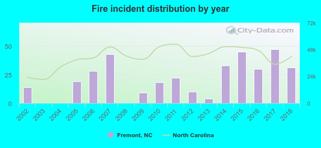 Based on the data from the years 2002 - 2018 the average number of fire incidents per year is 21. The highest number of fire incidents - 47 took place in 2017, and the least - 0 in 2003. The data has an increasing trend.
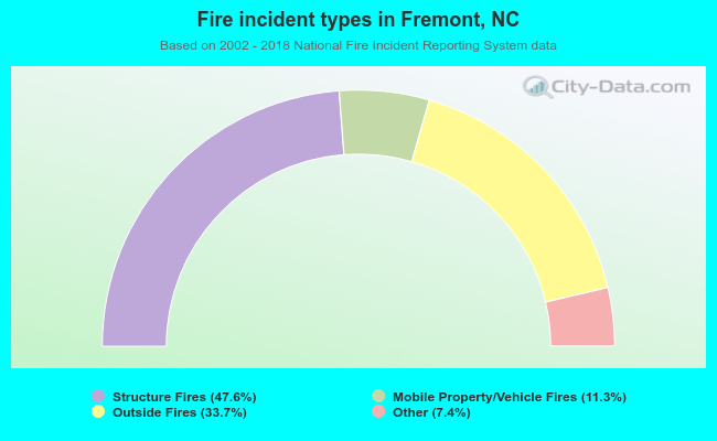 When looking into fire subcategories, the most reports belonged to: Structure Fires (47.6%), and Outside Fires (33.7%).
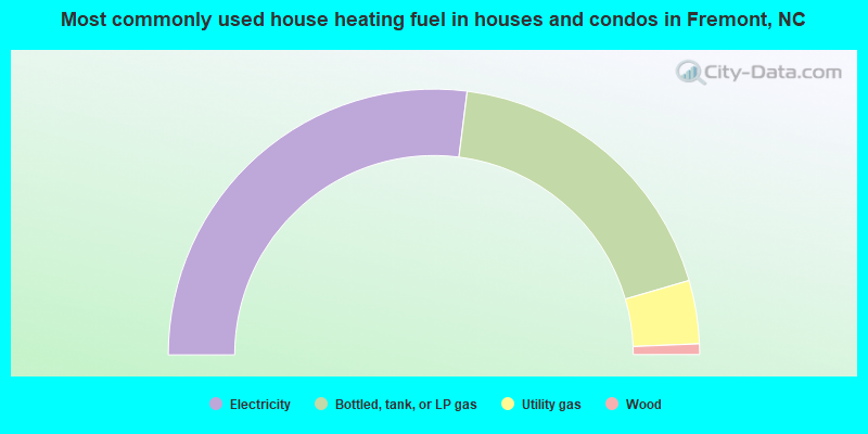
- 54.0%Electricity
- 37.0%Bottled, tank, or LP gas
- 7.7%Utility gas
- 1.3%Wood
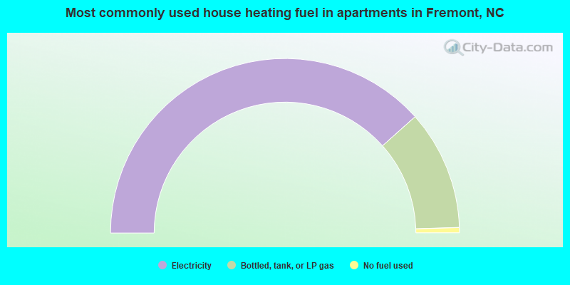
- 76.8%Electricity
- 22.2%Bottled, tank, or LP gas
- 1.0%No fuel used
Fremont compared to North Carolina state average:
- Median house value significantly below state average.
- Hispanic race population percentage below state average.
- Foreign-born population percentage below state average.
- House age significantly above state average.
- Number of college students significantly below state average.
- Percentage of population with a bachelor's degree or higher below state average.

|
Total of 163 patent applications in 2008-2024.