Gray, Kentucky
Submit your own pictures of this place and show them to the world
- OSM Map
- General Map
- Google Map
- MSN Map

| Males: 1,543 | |
| Females: 1,520 |
| Median resident age: | 34.3 years |
| Kentucky median age: | 35.9 years |
Zip code: 40734
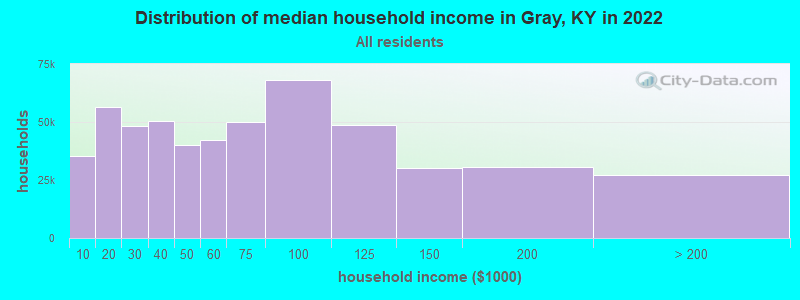
| Gray: | $39,775 |
| KY: | $59,341 |
Estimated per capita income in 2022: $21,312 (it was $10,847 in 2000)
Gray CCD income, earnings, and wages data
Estimated median house or condo value in 2022: $145,050 (it was $52,100 in 2000)
| Gray: | $145,050 |
| KY: | $196,300 |
Detailed information about poverty and poor residents in Gray, KY


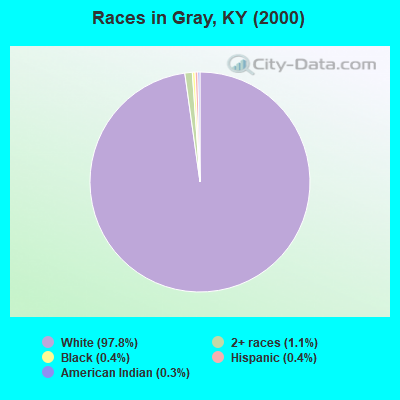
- 2,95697.8%White alone
- 321.1%Two or more races
- 130.4%Black alone
- 110.4%Hispanic
- 80.3%American Indian alone
- 20.07%Other race alone
Races in Gray detailed stats: ancestries, foreign born residents, place of birth
According to our research of Kentucky and other state lists, there were 15 registered sex offenders living in Gray, Kentucky as of April 19, 2024.
The ratio of all residents to sex offenders in Gray is 204 to 1.
 Recent articles from our blog. Our writers, many of them Ph.D. graduates or candidates, create easy-to-read articles on a wide variety of topics.

Current Local Time: EST time zone
Elevation: 1102 feet
Land area: 31.8 square miles.
Population density: 96 people per square mile (very low).

| Gray CCD: | 0.7% ($353) |
| Kentucky: | 0.8% ($610) |
Nearest city with pop. 50,000+: Knoxville, TN  (67.2 miles , pop. 173,890).
Nearest city with pop. 200,000+: Fayette, KY (80.4 miles , pop. 260,512).
Nearest city with pop. 1,000,000+: Chicago, IL (392.3 miles , pop. 2,896,016).
Nearest cities:
), ), ), ), )Latitude: 36.94 N, Longitude: 83.97 W
Area code commonly used in this area: 606

| Here: | 5.4% |
| Kentucky: | 3.8% |
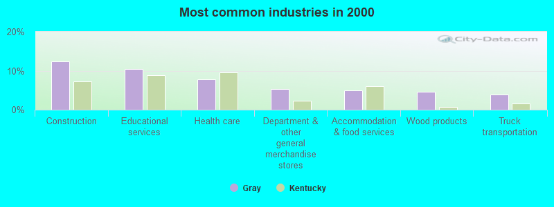
- Construction (12.4%)
- Educational services (10.4%)
- Health care (7.8%)
- Department & other general merchandise stores (5.3%)
- Accommodation & food services (4.9%)
- Wood products (4.5%)
- Truck transportation (3.9%)
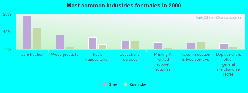
- Construction (19.0%)
- Wood products (8.1%)
- Truck transportation (7.0%)
- Educational services (5.0%)
- Printing & related support activities (3.8%)
- Accommodation & food services (3.5%)
- Department & other general merchandise stores (3.3%)
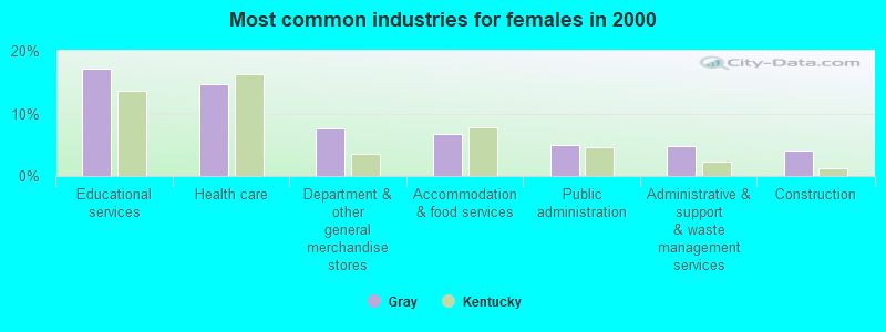
- Educational services (17.3%)
- Health care (14.8%)
- Department & other general merchandise stores (7.7%)
- Accommodation & food services (6.7%)
- Public administration (5.0%)
- Administrative & support & waste management services (4.8%)
- Construction (4.2%)
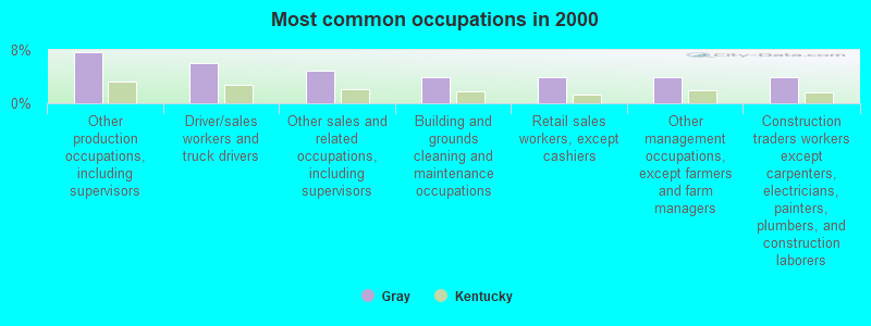
- Other production occupations, including supervisors (7.7%)
- Driver/sales workers and truck drivers (6.1%)
- Other sales and related occupations, including supervisors (4.9%)
- Building and grounds cleaning and maintenance occupations (4.0%)
- Retail sales workers, except cashiers (3.9%)
- Other management occupations, except farmers and farm managers (3.9%)
- Construction traders workers except carpenters, electricians, painters, plumbers, and construction laborers (3.9%)
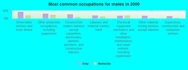
- Driver/sales workers and truck drivers (10.9%)
- Other production occupations, including supervisors (7.9%)
- Construction traders workers except carpenters, electricians, painters, plumbers, and construction laborers (7.0%)
- Laborers and material movers, hand (5.0%)
- Electrical equipment mechanics and other installation, maintenance, and repair workers, including supervisors (4.8%)
- Other material moving workers, except laborers (4.6%)
- Supervisors, construction and extraction workers (4.0%)
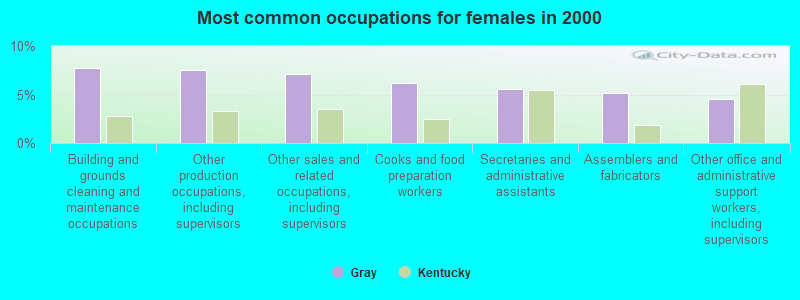
- Building and grounds cleaning and maintenance occupations (7.7%)
- Other production occupations, including supervisors (7.5%)
- Other sales and related occupations, including supervisors (7.1%)
- Cooks and food preparation workers (6.2%)
- Secretaries and administrative assistants (5.6%)
- Assemblers and fabricators (5.2%)
- Other office and administrative support workers, including supervisors (4.6%)
Average climate in Gray, Kentucky
Based on data reported by over 4,000 weather stations


Tornado activity:
Gray-area historical tornado activity is below Kentucky state average. It is 24% smaller than the overall U.S. average.
On 4/3/1974, a category F4 (max. wind speeds 207-260 mph) tornado 33.8 miles away from the Gray place center .
On 6/29/1973, a category F3 (max. wind speeds 158-206 mph) tornado 14.2 miles away from the place center injured 2 people and caused between $50,000 and $500,000 in damages.
Earthquake activity:
Gray-area historical earthquake activity is significantly above Kentucky state average. It is 71% greater than the overall U.S. average.On 7/27/1980 at 18:52:21, a magnitude 5.2 (5.1 MB, 4.7 MS, 5.0 UK, 5.2 UK, Class: Moderate, Intensity: VI - VII) earthquake occurred 87.2 miles away from Gray center
On 8/9/2020 at 12:07:37, a magnitude 5.1 (5.1 MW, Depth: 4.7 mi) earthquake occurred 162.7 miles away from Gray center
On 11/30/1973 at 07:48:41, a magnitude 4.7 (4.7 MB, 4.6 ML, Class: Light, Intensity: IV - V) earthquake occurred 79.3 miles away from the city center
On 4/18/2008 at 09:36:59, a magnitude 5.4 (5.1 MB, 4.8 MS, 5.4 MW, 5.2 MW) earthquake occurred 238.3 miles away from the city center
On 9/7/1988 at 02:28:09, a magnitude 4.6 (4.5 MB, 4.6 LG) earthquake occurred 83.0 miles away from the city center
On 8/23/2011 at 17:51:04, a magnitude 5.8 (5.8 MW, Depth: 3.7 mi) earthquake occurred 338.0 miles away from the city center
Magnitude types: regional Lg-wave magnitude (LG), body-wave magnitude (MB), local magnitude (ML), surface-wave magnitude (MS), moment magnitude (MW)
Natural disasters:
The number of natural disasters in Knox County (31) is a lot greater than the US average (15).Major Disasters (Presidential) Declared: 24
Emergencies Declared: 2
Causes of natural disasters: Floods: 22, Storms: 19, Mudslides: 8, Tornadoes: 7, Landslides: 6, Winter Storms: 5, Fires: 2, Snows: 2, Snowstorms: 2, Winds: 2, Blizzard: 1, Freeze: 1, Hurricane: 1, Snowfall: 1, Other: 1 (Note: some incidents may be assigned to more than one category).
Hospitals and medical centers near Gray:
- CHRISTIAN HEALTH CENTER (Nursing Home, about 6 miles away; CORBIN, KY)
- BARBOURVILLE HEALTH AND REHABILITATION CENTER (Nursing Home, about 7 miles away; BARBOURVILLE, KY)
- CORBIN HEALTH AND REHABILITATION CENTER (Nursing Home, about 10 miles away; CORBIN, KY)
- THE HERITAGE (Nursing Home, about 10 miles away; CORBIN, KY)
- SETON HOME HEALTH SERVICES (Home Health Center, about 12 miles away; LONDON, KY)
- PROFESSIONAL HOME HEALTH CARE, INC (Home Health Center, about 14 miles away; LONDON, KY)
Colleges/universities with over 2000 students nearest to Gray:
- University of the Cumberlands (about 18 miles; Williamsburg, KY; Full-time enrollment: 3,585)
- Lincoln Memorial University (about 31 miles; Harrogate, TN; FT enrollment: 3,706)
- Somerset Community College (about 37 miles; Somerset, KY; FT enrollment: 4,698)
- Hazard Community and Technical College (about 49 miles; Hazard, KY; FT enrollment: 2,087)
- Southeast Kentucky Community and Technical College (about 54 miles; Cumberland, KY; FT enrollment: 2,196)
- Eastern Kentucky University (about 58 miles; Richmond, KY; FT enrollment: 13,525)
- Walters State Community College (about 65 miles; Morristown, TN; FT enrollment: 4,359)
Points of interest:
Notable location: Bailey Switch Fire Department (A). Display/hide its location on the map
Churches in Gray include: Grays Church (A), Candle Ridge Church (B), Mount Pleasant Church (C), Richland Church (D), Poplar Grove Church (E), Emanuel Church (F). Display/hide their locations on the map
Cemeteries: Black Cemetery (1), Turner Cemetery (2), Brafford Cemetery (3), Powell Cemetery (4), Clouse Cemetery (5), Helton Cemetery (6), Johnson Cemetery (7). Display/hide their locations on the map
Streams, rivers, and creeks: Asher Branch (A), Dozier Fork (B), Cooley Branch (C), Wilson Branch (D), Stringer Branch (E), Lynn Camp Branch (F), Knox Fork (G), Jarvis Branch (H), Quillan Branch (I). Display/hide their locations on the map
| This place: | 2.5 people |
| Kentucky: | 2.5 people |
| This place: | 71.0% |
| Whole state: | 66.9% |
| This place: | 5.3% |
| Whole state: | 6.4% |
Likely homosexual households (counted as self-reported same-sex unmarried-partner households)
- Lesbian couples: 0.3% of all households
- Gay men: 0.3% of all households
| This place: | 29.1% |
| Whole state: | 15.8% |
| This place: | 13.8% |
| Whole state: | 6.6% |
For population 15 years and over in Gray:
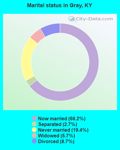
- Never married: 19.4%
- Now married: 66.2%
- Separated: 2.7%
- Widowed: 5.7%
- Divorced: 8.7%
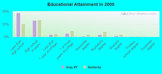
For population 25 years and over in Gray:
- High school or higher: 53.0%
- Bachelor's degree or higher: 7.9%
- Graduate or professional degree: 3.5%
- Unemployed: 6.1%
- Mean travel time to work (commute): 23.6 minutes
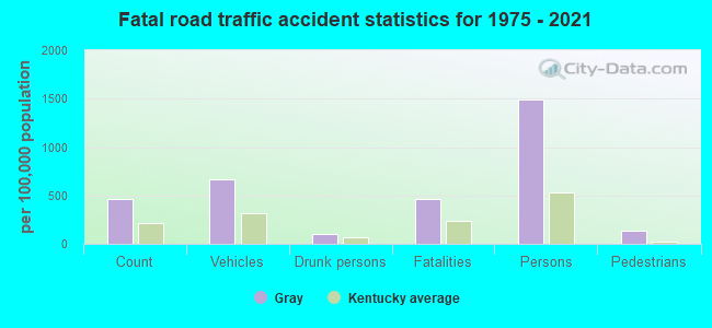
| Here: | 16.8 |
| Kentucky average: | 13.8 |
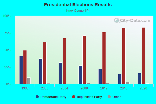
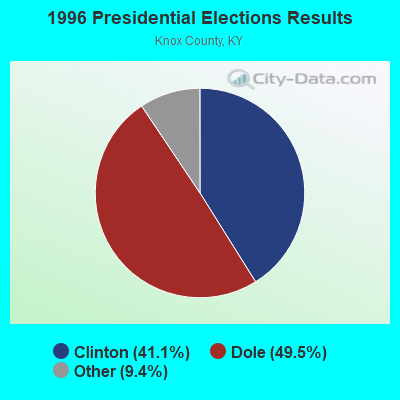
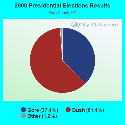
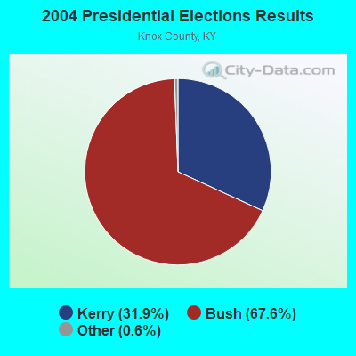
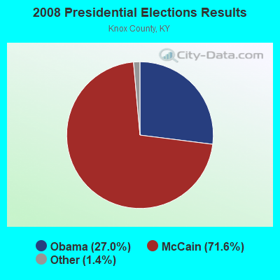
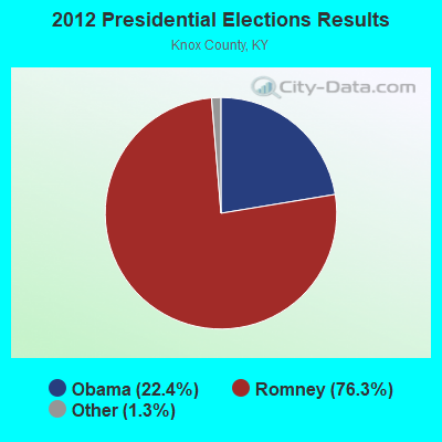
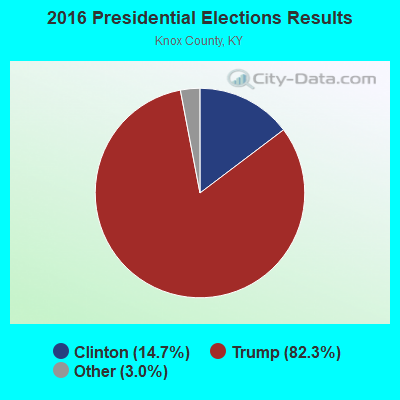
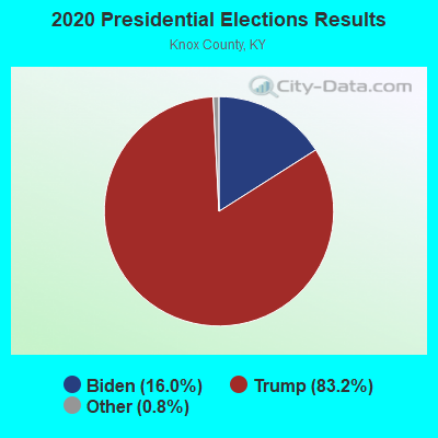
Graphs represent county-level data. Detailed 2008 Election Results
Religion statistics for Gray, KY (based on Knox County data)
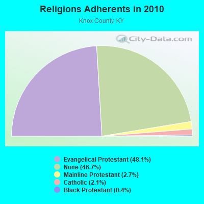
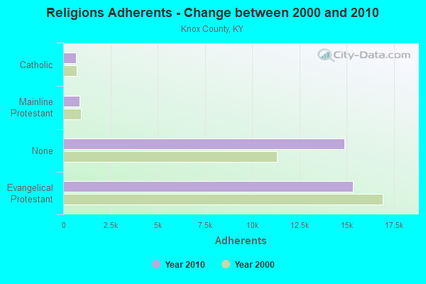
| Religion | Adherents | Congregations |
|---|---|---|
| Evangelical Protestant | 15,334 | 56 |
| Mainline Protestant | 859 | 5 |
| Catholic | 678 | 2 |
| Black Protestant | 123 | 1 |
| Other | - | 1 |
| None | 14,889 | - |
Food Environment Statistics:
| Here: | 2.77 / 10,000 pop. |
| Kentucky: | 2.19 / 10,000 pop. |
| Knox County: | 0.31 / 10,000 pop. |
| Kentucky: | 0.74 / 10,000 pop. |
| Knox County: | 3.38 / 10,000 pop. |
| State: | 4.36 / 10,000 pop. |
| Knox County: | 3.38 / 10,000 pop. |
| State: | 5.74 / 10,000 pop. |
| Knox County: | 11.6% |
| Kentucky: | 11.0% |
| Knox County: | 32.3% |
| Kentucky: | 30.0% |
| Knox County: | 21.0% |
| Kentucky: | 15.9% |
Businesses in Gray, KY
- U-Haul: 1
Strongest AM radio stations in Gray:
- WKDP (1330 AM; 5 kW; CORBIN, KY; Owner: EUBANKS BROADCASTING, INC.)
- WCTT (680 AM; 1 kW; CORBIN, KY; Owner: ENCORE COMMUNICATIONS, INC)
- WEKC (710 AM; daytime; 4 kW; WILLIAMSBURG, KY; Owner: GERALD PARKS)
- WKVL (850 AM; daytime; 50 kW; KNOXVILLE, TN; Owner: HORNE RADIO, LLC)
- WKLB (1290 AM; 5 kW; MANCHESTER, KY; Owner: BARKER BROADCASTING COMPANY, INC.)
- WYWY (950 AM; 1 kW; BARBOURVILLE, KY; Owner: BARBOURVILLE-COMMNITY BROADC/G CO IN)
- WMIK (560 AM; 2 kW; MIDDLESBORO, KY; Owner: GATEWAY BROADCASTING, INC.)
- WEZJ (1440 AM; 2 kW; WILLIAMSBURG, KY; Owner: WHITLEY BROADCASTING CO., INC.)
- WHAS (840 AM; 50 kW; LOUISVILLE, KY; Owner: CLEAR CHANNEL BROADCASTING LICENSES, INC.)
- WFSR (970 AM; 5 kW; HARLAN, KY; Owner: EASTERN BROADCASTING COMPAY)
- WHLN (1410 AM; 5 kW; HARLAN, KY)
- WFTG (1400 AM; 1 kW; LONDON, KY; Owner: F.T.G. BROADCASTING, INC.)
- WFGW (1010 AM; 50 kW; BLACK MOUNTAIN, NC; Owner: BLUE RIDGE BROADCASTING CORP.)
Strongest FM radio stations in Gray:
- WKDP-FM (99.5 FM; CORBIN, KY; Owner: EUBANKS BROADCASTING, INC.)
- WCTT-FM (107.3 FM; CORBIN, KY; Owner: ENCORE COMMUNICATIONS, INC.)
- WKKQ (96.1 FM; BARBOURVILLE, KY; Owner: BARBOURVILLE COMMUNITY B/NG CO.INC.)
- WVCT (91.5 FM; KEAVY, KY; Owner: VICTORY TRAINING SCHOOL CORP.)
- WWLT (103.1 FM; MANCHESTER, KY; Owner: VERNON R. BALDWIN, INC.)
- WMIK-FM (92.7 FM; MIDDLESBORO, KY; Owner: GATEWAY BROADCASTING, INC.)
- WYGE (92.3 FM; LONDON, KY; Owner: ETHEL HUFF BROADCASTING, LLC)
- WEKX (102.7 FM; JELLICO, TN; Owner: WHITLEY BROADCASTING CO., INC.)
- WRIL (106.3 FM; PINEVILLE, KY; Owner: PINE HILLS BROADCASTING, INC.)
- WEZJ-FM (104.3 FM; WILLIAMSBURG, KY; Owner: WHITLEY BROADCASTING CO., INC.)
- WTBK (105.7 FM; MANCHESTER, KY; Owner: MANCHESTER COMMUNICATIONS, INC.)
- WDVX (89.9 FM; CLINTON, TN; Owner: CUMBERLAND COMMUNITIES COMMUNI CORP.)
- WWEL (103.9 FM; LONDON, KY; Owner: F.T.G. BROADCASTING, INC.)
- WSEH (102.7 FM; CUMBERLAND, KY; Owner: CUMBERLAND CITY BROADCASTING, INC.)
- WSGS (101.1 FM; HAZARD, KY; Owner: MOUNTAIN BROADCASTING SERVICE, INC.)
- WTUK (105.1 FM; HARLAN, KY; Owner: EASTERN BROADCASTING COMPANY)
- WCTU (105.9 FM; TAZEWELL, TN; Owner: STAIR COMPANY, INC)
- WAXM (93.5 FM; BIG STONE GAP, VA; Owner: VALLEY BROADCASTING, INC.)
- WIMZ-FM (103.5 FM; KNOXVILLE, TN; Owner: SOUTH CENTRAL COMM., CORP.)
- WZQQ (97.9 FM; HYDEN, KY; Owner: LESLIE COUNTY BROADCASTING, INC.)
TV broadcast stations around Gray:
- W33BK (Channel 33; CORBIN, KY; Owner: TRINITY BROADCASTING NETWORK)
- WVTN-LP (Channel 48; CORBIN, KY; Owner: VICTORY TRAINING SCHOOL CORP.)
- W39CK (Channel 20; CORBIN, KY; Owner: DEREK RAY EUBANKS)
- W07AH (Channel 7; BARBOURVILLE, KY; Owner: BARBOURVILLE AREA TELEVISION CORP.)
- W04AF (Channel 4; BARBOURVILLE, KY; Owner: BARBOURVILLE AREA TELEVISION CORP.)
FCC Registered Antenna Towers:
35 (See the full list of FCC Registered Antenna Towers in Gray)FCC Registered Broadcast Land Mobile Towers:
5- Lat: 36.953972 Lon: -83.977972, Call Sign: WPJM462,
Assigned Frequencies: 160.020 MHz, 160.050 MHz, Grant Date: 09/26/2011, Expiration Date: 08/03/2021, Cancellation Date: 01/08/2022, Certifier: Dallas R Eubanks, Registrant: Professional Licensing Consultants, Inc., Rockville, MD 20849, Phone: (301) 309-2380, Fax: (301) 309-1996
- JOHNSON HOLLOW, Lat: 36.944806 Lon: -83.969556, Call Sign: KIA297,
Assigned Frequencies: 173.350 MHz, 173.350 MHz, Grant Date: 11/23/2010, Expiration Date: 01/30/2021, Cancellation Date: 04/03/2021, Registrant: Pros Rf, 5219 Adairville Rd, Franklin, KY 42134-7500, Phone: (270) 908-4402, Fax: (786) 549-7864, Email:
- Top Of Gillium Knob 5 Km E (Lat: 36.945083 Lon: -83.968528), Type: Tower, Structure height: 79 m, Call Sign: KNBH652,
Assigned Frequencies: 37.5400 MHz, 37.8000 MHz, Grant Date: 07/08/2021, Expiration Date: 08/29/2031, Registrant: Utility Telecom Consulting Group, Inc., 9850 S Maryland Pkwy Ste A5-108, Las Vegas, NV 89183, Phone: (702) 340-1706, Email:
- Lat: 36.945000 Lon: -83.968611, Call Sign: WPXT570,
Assigned Frequencies: 466.462 MHz, 466.687 MHz, 466.987 MHz, 467.162 MHz, 467.400 MHz, 468.237 MHz, 468.512 MHz, 468.762 MHz, 468.962 MHz, 469.437 MHz, Grant Date: 06/09/2003, Expiration Date: 06/09/2013, Cancellation Date: 10/19/2005, Certifier: Terry Estes, Registrant: Ekpc, 4775 Lexington Road, Winchester, KY 40392-0707, Phone: (859) 744-4812, Fax: (859) 744-6008, Email:
- Lat: 36.945000 Lon: -83.968611, Call Sign: WQBN528, Licensee ID: L00003833,
Assigned Frequencies: 466.462 MHz, 466.687 MHz, 467.162 MHz, 467.400 MHz, 468.237 MHz, 468.512 MHz, 468.762 MHz, 468.962 MHz, 469.437 MHz, Grant Date: 11/10/2004, Expiration Date: 11/10/2014, Cancellation Date: 10/24/2007, Certifier: Todd R Ellis, Registrant: East Kentucky Power Cooperative, Inc., 4775 Lexington Rd, Winchester, KY 40392-0707, Phone: (859) 745-9391, Fax: (859) 744-6008, Email:
FCC Registered Microwave Towers:
8 (See the full list of FCC Registered Microwave Towers in this town)FCC Registered Amateur Radio Licenses:
20 (See the full list of FCC Registered Amateur Radio Licenses in Gray)FAA Registered Aircraft:
1- Aircraft: CIRRUS DESIGN CORP SR22 (Category: Land, Seats: 4, Weight: Up to 12,499 Pounds), Engine: CONT MOTOR IO-550 SERIES (300 HP) (Reciprocating)
N-Number: 474CD, N474CD, N-474CD, Serial Number: 1573, Year manufactured: 2005, Airworthiness Date: 08/23/2005, Certificate Issue Date: 08/08/2019
Registrant (LLC): Airmax LLC, 6423 Ky 1232 Ste 9, Gray, KY 40734
2002 - 2018 National Fire Incident Reporting System (NFIRS) incidents
- Fire incident types reported to NFIRS in Gray, KY
- 13838.1%Outside Fires
- 13537.3%Structure Fires
- 6919.1%Mobile Property/Vehicle Fires
- 205.5%Other
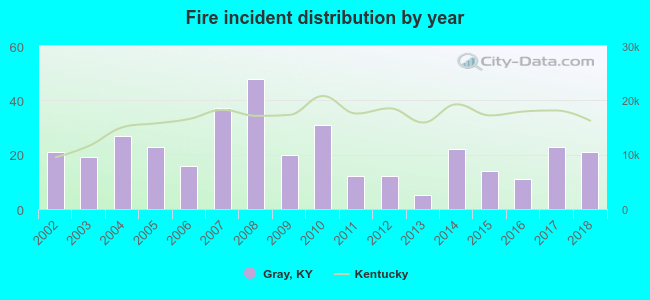 Based on the data from the years 2002 - 2018 the average number of fires per year is 21. The highest number of fires - 48 took place in 2008, and the least - 5 in 2013. The data has a constant trend.
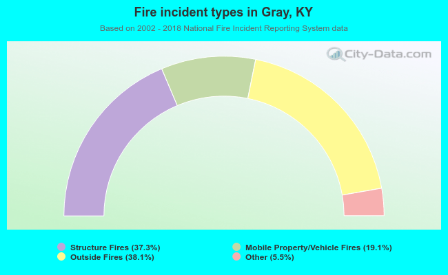 When looking into fire subcategories, the most reports belonged to: Outside Fires (38.1%), and Structure Fires (37.3%).
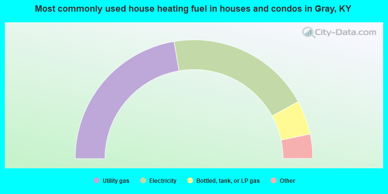
- 44.6%Utility gas
- 39.4%Electricity
- 9.3%Bottled, tank, or LP gas
- 3.1%Coal or coke
- 2.1%Fuel oil, kerosene, etc.
- 1.4%Wood
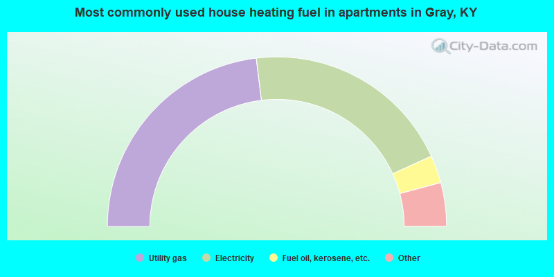
- 46.1%Utility gas
- 40.3%Electricity
- 5.3%Fuel oil, kerosene, etc.
- 3.4%Coal or coke
- 2.4%Bottled, tank, or LP gas
- 2.4%Wood
Gray compared to Kentucky state average:
- Unemployed percentage below state average.
- Black race population percentage significantly below state average.
- Hispanic race population percentage significantly below state average.
- Median age below state average.
- Foreign-born population percentage significantly below state average.
- Length of stay since moving in significantly above state average.
- Number of rooms per house significantly below state average.
- House age significantly below state average.
- Percentage of population with a bachelor's degree or higher significantly below state average.

|
Total of 1 patent application in 2008-2024.