Gregory, Kentucky
Submit your own pictures of this place and show them to the world
- OSM Map
- General Map
- Google Map
- MSN Map

| Males: 629 | |
| Females: 607 |
| Median resident age: | 37.9 years |
| Kentucky median age: | 35.9 years |
Zip code: 42633
| Gregory: | $39,657 |
| KY: | $59,341 |
Estimated per capita income in 2022: $20,865 (it was $9,599 in 2000)
Gregory CCD income, earnings, and wages data
Estimated median house or condo value in 2022: $102,354 (it was $36,000 in 2000)
| Gregory: | $102,354 |
| KY: | $196,300 |
Mean prices in 2022: all housing units: $140,553; detached houses: $157,000; mobile homes: $73,995
Detailed information about poverty and poor residents in Gregory, KY
Compare current foreclosures near Gregory, KY:
| Photo | Address | Area | Beds / Baths | Price | Details |
|---|---|---|---|---|---|

|
#1
Jaylans Way
Somerset, KY 42503
|
2,100 sq. feet
|
2 baths 3 beds |
show details | |

|
#2
Adair St
Monticello, KY 42633
|
1,144 sq. feet
|
1 baths 3 beds |
show details | |

|
#3
Auburn Ave
Somerset, KY 42501
|
1,252 sq. feet
|
2 baths 3 beds |
show details | |

|
#4
Stanton Ln
Somerset, KY 42501
|
1,404 sq. feet
|
2 baths 3 beds |
show details | |

|
#5
Ridgeview Dr
Somerset, KY 42503
|
1,608 sq. feet
|
1 baths 3 beds |
show details | |

|
#6
Green Acres Dr
Monticello, KY 42633
|
1,057 sq. feet
|
1 baths 3 beds |
show details | |

|
#7
Green Acres Dr
Monticello, KY 42633
|
2,212 sq. feet
|
2 baths 3 beds |
show details | |

|
#8
Pine Tree Rd
Nancy, KY 42544
|
1,300 sq. feet
|
1 baths 3 beds |
show details | |

|
#9
Cumberland Dr
Somerset, KY 42503
|
1,870 sq. feet
|
2 baths 3 beds |
show details | |

|
#10
W Highway 92
Monticello, KY 42633
|
1,931 sq. feet
|
2 baths 3 beds |
show details |
| Photo | Address | Area | Beds / Baths | Price | Details |
|---|---|---|---|---|---|

|
#11
Hollow Creek Dr
Somerset, KY 42503
|
2,077 sq. feet
|
3 baths 4 beds |
show details | |

|
#12
Lucky Leaf Dr
Somerset, KY 42503
|
1,776 sq. feet
|
2 baths 3 beds |
show details | |

|
#13
Eagle Dr
Burnside, KY 42519
|
1,276 sq. feet
|
1 baths 3 beds |
show details | |

|
#14
Eagle Dr
Burnside, KY 42519
|
560 sq. feet
|
2 baths 4 beds |
show details | |

|
#15
Windy Hills Dr
Somerset, KY 42501
|
3,308 sq. feet
|
2 baths 3 beds |
show details | |

|
#16
Heartland Dr
Somerset, KY 42503
|
1,661 sq. feet
|
1 baths 3 beds |
show details | |

|
#17
Elihu Cabin Hollow Rd
Somerset, KY 42501
|
725 sq. feet
|
1 baths 2 beds |
show details | |

|
#18
Quail Run
Somerset, KY 42503
|
1,802 sq. feet
|
2 baths 3 beds |
show details | |

|
#19
Sycamore Trl
Somerset, KY 42501
|
1,058 sq. feet
|
2 baths 3 beds |
show details | |

|
#20
Meagan Ct
Monticello, KY 42633
|
978 sq. feet
|
1 baths 2 beds |
show details |
| Photo | Address | Area | Beds / Baths | Price | Details |
|---|---|---|---|---|---|

|
#21
Wray Hill Ln
Monticello, KY 42633
|
1,320 sq. feet
|
1 baths 4 beds |
show details | |

|
#22
Pond Meadow Rd
Somerset, KY 42503
|
1,665 sq. feet
|
2 baths 3 beds |
show details | |

|
#23
Michigan Ave
Monticello, KY 42633
|
1,092 sq. feet
|
1 baths 4 beds |
show details | |

|
#24
E Highway 1248
Somerset, KY 42503
|
972 sq. feet
|
1 baths 2 beds |
show details | |

|
#25
Hearthside Dr
Somerset, KY 42503
|
1,536 sq. feet
|
2 baths 3 beds |
show details | |

|
#26
Highway 790
Bronston, KY 42518
|
884 sq. feet
|
- baths 3 beds |
show details | |

|
#27
Charlottes Pl
Somerset, KY 42503
|
- sq. feet
|
- baths - beds |
show details | |

|
#28
Oak Hill Cir
Parkers Lake, KY 42634
|
- sq. feet
|
- baths - beds |
show details | |

|
#29
W Williamsburg St
Whitley City, KY 42653
|
- sq. feet
|
- baths - beds |
show details | |

|
#30
Doc Winchester Rd
Stearns, KY 42647
|
- sq. feet
|
- baths - beds |
show details |
| Photo | Address | Area | Beds / Baths | Price | Details |
|---|---|---|---|---|---|

|
#31
Brook View Rd
Nancy, KY 42544
|
- sq. feet
|
- baths - beds |
show details | |

|
#32
Highway 235
Nancy, KY 42544
|
- sq. feet
|
- baths - beds |
show details | |

|
#33
Myrtle Dr
Stearns, KY 42647
|
- sq. feet
|
- baths - beds |
show details | |

|
#34
Sandhill Rd
Whitley City, KY 42653
|
980 sq. feet
|
- baths - beds |
show details | |

|
#35
Magnolia Ave
Somerset, KY 42503
|
- sq. feet
|
- baths - beds |
show details | |

|
#36
Winners Circle Dr, Apt 31
Somerset, KY 42503
|
- sq. feet
|
- baths - beds |
show details | |

|
#37
Rush Branch Rd
Somerset, KY 42501
|
- sq. feet
|
- baths - beds |
show details | |

|
#38
Elihu Cabin Hollow Rd
Somerset, KY 42501
|
- sq. feet
|
- baths - beds |
show details | |

|
#39
Kit Cowan Rd
Somerset, KY 42501
|
- sq. feet
|
- baths - beds |
show details | |

|
#40
Somerset Vlg
Somerset, KY 42501
|
- sq. feet
|
- baths - beds |
show details |
| Photo | Address | Area | Beds / Baths | Price | Details |
|---|---|---|---|---|---|

|
#41
Hidden Valley Ln
Monticello, KY 42633
|
1,248 sq. feet
|
- baths - beds |
show details | |

|
#42
Independence Dr Apt 2
Somerset, KY 42501
|
- sq. feet
|
- baths - beds |
show details | |

|
#43
Richardson Rd
Nancy, KY 42544
|
- sq. feet
|
- baths - beds |
show details | |

|
#44
Sam Alley Rd
Monticello, KY 42633
|
924 sq. feet
|
- baths - beds |
show details | |

|
#45
E Appletree Rd
Stearns, KY 42647
|
- sq. feet
|
- baths - beds |
show details | |

|
#46
Holly Hill Dr # A
Somerset, KY 42503
|
- sq. feet
|
- baths - beds |
show details | |

|
#47
Zion Rd
Bronston, KY 42518
|
- sq. feet
|
- baths - beds |
show details | |

|
#48
Rebecca Rd
Whitley City, KY 42653
|
- sq. feet
|
- baths - beds |
show details | |

|
#49
Highway 196
Nancy, KY 42544
|
- sq. feet
|
- baths - beds |
show details | |

|
Check over 1 million property listings on Foreclosure.com!
|
browse all offers | |||

- 1,18298.4%White alone
- 121.0%Hispanic
- 70.6%Two or more races
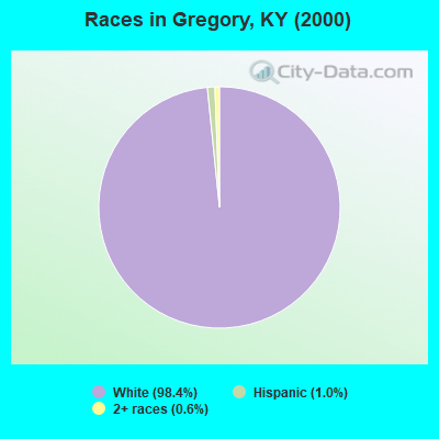
Races in Gregory detailed stats: ancestries, foreign born residents, place of birth
 Recent articles from our blog. Our writers, many of them Ph.D. graduates or candidates, create easy-to-read articles on a wide variety of topics.

Current Local Time: EST time zone
Elevation: 952 feet
Land area: 80.6 square miles.
Population density: 15 people per square mile (very low).

| Gregory CCD: | 0.6% ($233) |
| Kentucky: | 0.8% ($610) |
Nearest city with pop. 50,000+: Knoxville, TN  (72.3 miles , pop. 173,890).
Nearest city with pop. 200,000+: Fayette, KY (83.1 miles , pop. 260,512).
Nearest city with pop. 1,000,000+: Chicago, IL (381.5 miles , pop. 2,896,016).
Nearest cities:
), ), ), ), Latitude: 36.84 N, Longitude: 84.67 W
Area code commonly used in this area: 606


| Here: | 5.0% |
| Kentucky: | 3.8% |

- Educational services (13.5%)
- Wood products (12.2%)
- Construction (10.0%)
- Data processing, libraries, other information services (6.7%)
- Transportation equipment (6.5%)
- Health care (6.2%)
- Agriculture, forestry, fishing & hunting (3.5%)

- Wood products (18.3%)
- Construction (15.7%)
- Transportation equipment (11.3%)
- Educational services (7.8%)
- Agriculture, forestry, fishing & hunting (6.1%)
- Machinery (6.1%)
- Repair & maintenance (5.7%)

- Educational services (21.1%)
- Data processing, libraries, other information services (15.8%)
- Health care (8.2%)
- Social assistance (6.4%)
- Food & beverage stores (5.3%)
- Food (4.7%)
- Accommodation & food services (4.7%)

- Other production occupations, including supervisors (10.5%)
- Carpenters (6.7%)
- Assemblers and fabricators (6.7%)
- Other office and administrative support workers, including supervisors (6.5%)
- Bus drivers (5.7%)
- Woodworkers (5.7%)
- Other teachers, instructors, education, training, and library occupations (5.0%)

- Carpenters (11.7%)
- Woodworkers (10.0%)
- Other production occupations, including supervisors (9.6%)
- Other material moving workers, except laborers (6.5%)
- Assemblers and fabricators (6.5%)
- Vehicle and mobile equipment mechanics, installers, and repairers (5.2%)
- Metal workers and plastic workers (5.2%)

- Other office and administrative support workers, including supervisors (15.2%)
- Other teachers, instructors, education, training, and library occupations (11.7%)
- Other production occupations, including supervisors (11.7%)
- Other sales and related occupations, including supervisors (9.9%)
- Assemblers and fabricators (7.0%)
- Bus drivers (6.4%)
- Waiters and waitresses (4.7%)
Average climate in Gregory, Kentucky
Based on data reported by over 4,000 weather stations


(lower is better)

Air Quality Index (AQI) level in 2022 was 62.9. This is about average.
| City: | 62.9 |
| U.S.: | 72.6 |

Ozone [ppb] level in 2022 was 28.6. This is about average. Closest monitor was 18.4 miles away from the city center.
| City: | 28.6 |
| U.S.: | 33.3 |

Particulate Matter (PM2.5) [µg/m3] level in 2022 was 7.87. This is about average. Closest monitor was 18.4 miles away from the city center.
| City: | 7.87 |
| U.S.: | 8.11 |
Tornado activity:
Gregory-area historical tornado activity is slightly below Kentucky state average. It is 12% greater than the overall U.S. average.
On 4/3/1974, a category F4 (max. wind speeds 207-260 mph) tornado 8.3 miles away from the Gregory place center killed 10 people and injured 113 people and caused between $5000 and $50,000 in damages.
On 4/3/1974, a category F4 tornado 10.0 miles away from the place center .
Earthquake activity:
Gregory-area historical earthquake activity is significantly above Kentucky state average. It is 97% greater than the overall U.S. average.On 7/27/1980 at 18:52:21, a magnitude 5.2 (5.1 MB, 4.7 MS, 5.0 UK, 5.2 UK, Class: Moderate, Intensity: VI - VII) earthquake occurred 102.8 miles away from the city center
On 4/18/2008 at 09:36:59, a magnitude 5.4 (5.1 MB, 4.8 MS, 5.4 MW, 5.2 MW) earthquake occurred 208.4 miles away from Gregory center
On 11/30/1973 at 07:48:41, a magnitude 4.7 (4.7 MB, 4.6 ML, Class: Light, Intensity: IV - V) earthquake occurred 82.0 miles away from the city center
On 4/18/2008 at 09:36:59, a magnitude 5.2 (5.2 MW, Depth: 8.9 mi) earthquake occurred 208.3 miles away from the city center
On 8/9/2020 at 12:07:37, a magnitude 5.1 (5.1 MW, Depth: 4.7 mi) earthquake occurred 200.2 miles away from the city center
On 9/7/1988 at 02:28:09, a magnitude 4.6 (4.5 MB, 4.6 LG) earthquake occurred 100.3 miles away from Gregory center
Magnitude types: regional Lg-wave magnitude (LG), body-wave magnitude (MB), local magnitude (ML), surface-wave magnitude (MS), moment magnitude (MW)
Natural disasters:
The number of natural disasters in Wayne County (15) is near the US average (15).Major Disasters (Presidential) Declared: 11
Emergencies Declared: 2
Causes of natural disasters: Floods: 8, Storms: 6, Mudslides: 3, Tornadoes: 3, Winter Storms: 3, Landslides: 2, Winds: 2, Blizzard: 1, Freeze: 1, Heavy Rain: 1, Hurricane: 1, Snow: 1, Snowfall: 1, Snowstorm: 1, Other: 1 (Note: some incidents may be assigned to more than one category).
Colleges/universities with over 2000 students nearest to Gregory:
- Somerset Community College (about 16 miles; Somerset, KY; Full-time enrollment: 4,698)
- University of the Cumberlands (about 30 miles; Williamsburg, KY; FT enrollment: 3,585)
- Lindsey Wilson College (about 40 miles; Columbia, KY; FT enrollment: 2,552)
- Campbellsville University (about 52 miles; Campbellsville, KY; FT enrollment: 2,948)
- Lincoln Memorial University (about 60 miles; Harrogate, TN; FT enrollment: 3,706)
- Tennessee Technological University (about 66 miles; Cookeville, TN; FT enrollment: 9,761)
- Eastern Kentucky University (about 66 miles; Richmond, KY; FT enrollment: 13,525)
Points of interest:
Notable locations in Gregory: Cullom Rock (A), The Thrashing Rock (B), The Grass Field (C), The Hawk Point (D), A Salt Spring and Deer Lick (E), Buffalo Wallow (F), Jericho (G), Mack Tract (H), Sifter Rock (I). Display/hide their locations on the map
Churches in Gregory include: Concord Baptist Church (A), Clay Hill Church (B), Big Sinking Church (C), Zion Church (D), Shiloh Church (E), Mount Hermon Church (F), Freedom Church (G). Display/hide their locations on the map
Cemeteries: Morrow Cemetery (1), Keith Cemetery (2), Jonesville Cemetery (3), Hardwick Cemetery (4), Carrender-Tuttle Cemetery (5), Kidd Cemetery (6), Cowan Cemetery (7). Display/hide their locations on the map
Streams, rivers, and creeks: Chicken Creek (A), Crabtree Branch (B), Denney Creek (C), Dry Fork (D), Lick Creek (E), Lincoln Creek (F), Little South Fork (G), Long Branch (H), Lovell Branch (I). Display/hide their locations on the map
| This place: | 2.4 people |
| Kentucky: | 2.5 people |
| This place: | 72.8% |
| Whole state: | 66.9% |
| This place: | 3.7% |
| Whole state: | 6.4% |
Likely homosexual households (counted as self-reported same-sex unmarried-partner households)
- Lesbian couples: 0.6% of all households
- Gay men: 0.3% of all households
| This place: | 28.1% |
| Whole state: | 15.8% |
| This place: | 9.9% |
| Whole state: | 6.6% |
For population 15 years and over in Gregory:

- Never married: 18.4%
- Now married: 69.3%
- Separated: 0.5%
- Widowed: 5.2%
- Divorced: 7.0%
For population 25 years and over in Gregory:
- High school or higher: 51.0%
- Bachelor's degree or higher: 0.0%
- Graduate or professional degree: 0.0%
- Unemployed: 5.9%
- Mean travel time to work (commute): 27.7 minutes


| Here: | 17.9 |
| Kentucky average: | 13.8 |
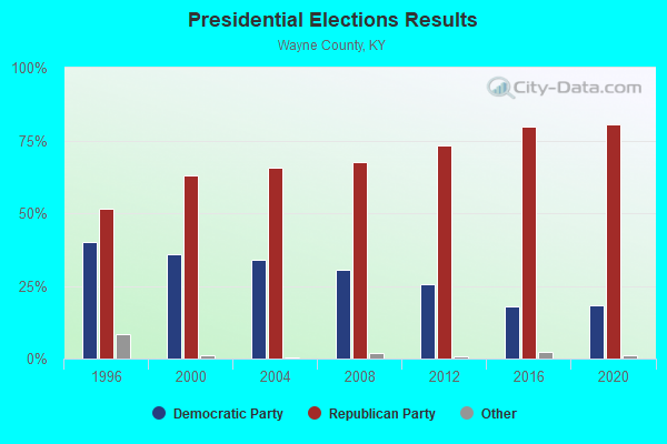
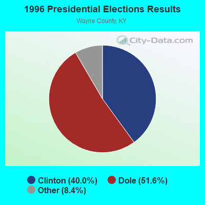
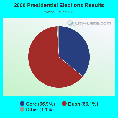
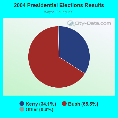
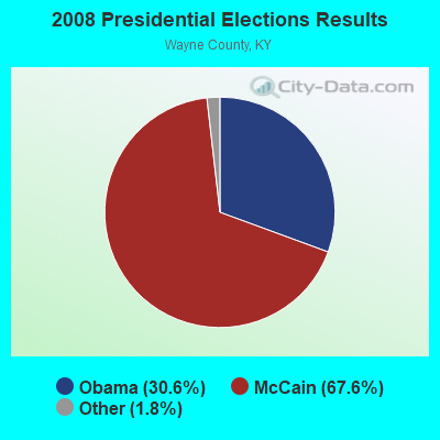
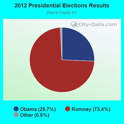
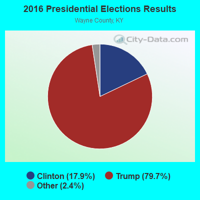
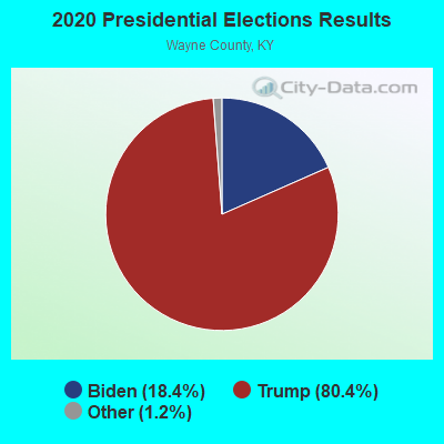
Graphs represent county-level data. Detailed 2008 Election Results
Religion statistics for Gregory, KY (based on Wayne County data)
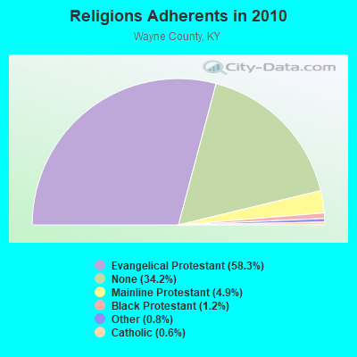
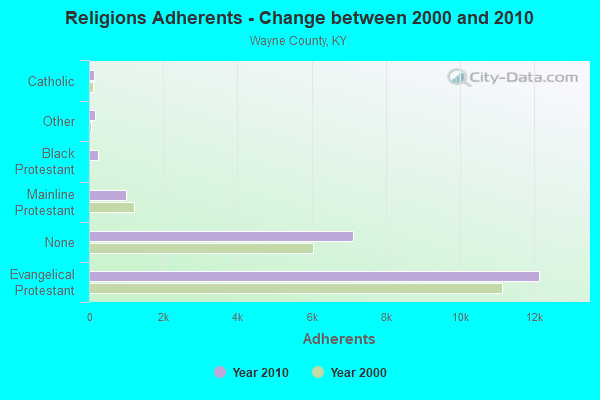
| Religion | Adherents | Congregations |
|---|---|---|
| Evangelical Protestant | 12,144 | 38 |
| Mainline Protestant | 1,010 | 8 |
| Black Protestant | 242 | 2 |
| Other | 158 | 2 |
| Catholic | 134 | 1 |
| None | 7,125 | - |
Food Environment Statistics:
| Wayne County: | 3.89 / 10,000 pop. |
| State: | 2.19 / 10,000 pop. |
| Wayne County: | 0.49 / 10,000 pop. |
| Kentucky: | 0.25 / 10,000 pop. |
| Wayne County: | 0.49 / 10,000 pop. |
| Kentucky: | 0.74 / 10,000 pop. |
| Wayne County: | 3.40 / 10,000 pop. |
| Kentucky: | 4.36 / 10,000 pop. |
| This county: | 2.91 / 10,000 pop. |
| Kentucky: | 5.74 / 10,000 pop. |
| Wayne County: | 10.9% |
| Kentucky: | 11.0% |
| Wayne County: | 31.1% |
| Kentucky: | 30.0% |
| Wayne County: | 17.8% |
| Kentucky: | 15.9% |
Strongest AM radio stations in Gregory:
- WKVL (850 AM; daytime; 50 kW; KNOXVILLE, TN; Owner: HORNE RADIO, LLC)
- WEKC (710 AM; daytime; 4 kW; WILLIAMSBURG, KY; Owner: GERALD PARKS)
- WFLW (1360 AM; 1 kW; MONTICELLO, KY; Owner: STEPHEN W. STAPLES, JR.)
- WHAS (840 AM; 50 kW; LOUISVILLE, KY; Owner: CLEAR CHANNEL BROADCASTING LICENSES, INC.)
- WSM (650 AM; 50 kW; NASHVILLE, TN; Owner: GAYLORD ENTERTAINMENT COMPANY)
- WKDP (1330 AM; 5 kW; CORBIN, KY; Owner: EUBANKS BROADCASTING, INC.)
- WWAM (820 AM; daytime; 50 kW; JASPER, TN; Owner: SHELTON BROADCASTING SYSTEM)
- WAMB (1160 AM; 50 kW; DONELSON, TN; Owner: GREAT SOUTHERN BROADCASTING COMPANY, INC.)
- WFLI (1070 AM; 50 kW; LOOKOUT MOUNTAIN, TN; Owner: WFLI, INC.)
- WKDA (1200 AM; 50 kW; NASHVILLE, TN; Owner: RADIO NASHVILLE, INC.)
- WKEQ (910 AM; 0 kW; BURNSIDE, KY; Owner: CAPSTAR TX LIMITED PARTNERSHIP)
- WNQM (1300 AM; 50 kW; NASHVILLE, TN; Owner: WNQM. INC.)
- WTLO (1480 AM; 1 kW; SOMERSET, KY; Owner: CUMBERLAND COMMUNICATIONS, INC.)
Strongest FM radio stations in Gregory:
- WMKZ (93.1 FM; MONTICELLO, KY; Owner: MONTICELLO-WAYNE COUNTY MEDIA, INC.)
- WKYM (101.7 FM; MONTICELLO, KY; Owner: STEPHEN W. STAPLES JR.)
- WSEK (97.1 FM; SOMERSET, KY; Owner: CAPSTAR TX LIMITED PARTNERSHIP)
- WEKX (102.7 FM; JELLICO, TN; Owner: WHITLEY BROADCASTING CO., INC.)
- WHAY (105.9 FM; WHITLEY CITY, KY; Owner: TIM LAVENDER)
- WDVX (89.9 FM; CLINTON, TN; Owner: CUMBERLAND COMMUNITIES COMMUNI CORP.)
- WTHL (90.5 FM; SOMERSET, KY; Owner: SOMERSET EDUCATIONAL BROADCASTING FOUNDATION)
- WEZJ-FM (104.3 FM; WILLIAMSBURG, KY; Owner: WHITLEY BROADCASTING CO., INC.)
- WKII-FM (102.3 FM; SOMERSET, KY; Owner: CAPSTAR TX LIMITED PARTNERSHIP)
- WMIK-FM (92.7 FM; MIDDLESBORO, KY; Owner: GATEWAY BROADCASTING, INC.)
- WLLK (93.9 FM; BURNSIDE, KY; Owner: CAPSTAR TX LIMITED PARTNERSHIP)
- WYGE (92.3 FM; LONDON, KY; Owner: ETHEL HUFF BROADCASTING, LLC)
- W277AA (103.3 FM; SOMERSET, KY; Owner: WESTERN KENTUCKY UNIVERSITY)
- WJRS (104.9 FM; JAMESTOWN, KY; Owner: LAKE CUMBERLAND BROADCASTERS)
TV broadcast stations around Gregory:
- WKSO-TV (Channel 29; SOMERSET, KY; Owner: KENTUCKY AUTHORITY FOR EDUCATIONAL TV)

- 37.7%Electricity
- 34.6%Wood
- 15.0%Bottled, tank, or LP gas
- 6.4%Utility gas
- 4.6%Coal or coke
- 1.8%No fuel used

- 38.9%Wood
- 25.9%Fuel oil, kerosene, etc.
- 18.5%Bottled, tank, or LP gas
- 9.3%Electricity
- 7.4%Utility gas
Gregory compared to Kentucky state average:
- Median house value below state average.
- Unemployed percentage below state average.
- Black race population percentage significantly below state average.
- Hispanic race population percentage significantly below state average.
- Foreign-born population percentage significantly below state average.
- Renting percentage below state average.
- Length of stay since moving in significantly above state average.
- Number of rooms per house significantly below state average.
- House age significantly below state average.
- Number of college students below state average.
- Percentage of population with a bachelor's degree or higher significantly below state average.