Groton, New Hampshire
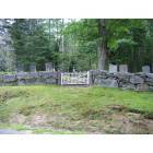
Groton: Cemetary on River Road, Groton NH
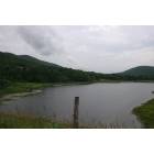
Groton: Baker River
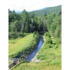
Groton: South Branch Baker River, Groton NH
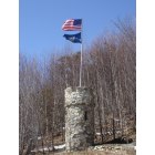
Groton: Tower of the half moon
- add
your


Submit your own pictures of this town and show them to the world
Detailed information about poverty and poor residents in Groton, NH
 Recent articles from our blog. Our writers, many of them Ph.D. graduates or candidates, create easy-to-read articles on a wide variety of topics.

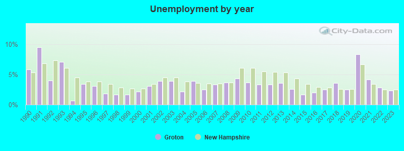
| Here: | 2.3% |
| New Hampshire: | 2.5% |
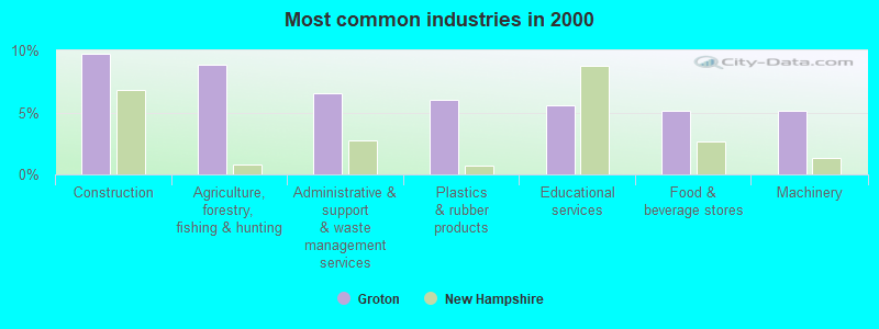
- Construction (9.8%)
- Agriculture, forestry, fishing & hunting (8.8%)
- Administrative & support & waste management services (6.5%)
- Plastics & rubber products (6.0%)
- Educational services (5.6%)
- Food & beverage stores (5.1%)
- Machinery (5.1%)
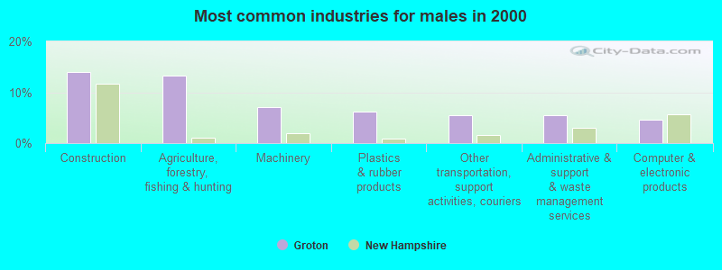
- Construction (14.1%)
- Agriculture, forestry, fishing & hunting (13.3%)
- Machinery (7.0%)
- Plastics & rubber products (6.2%)
- Other transportation, support activities, couriers (5.5%)
- Administrative & support & waste management services (5.5%)
- Computer & electronic products (4.7%)
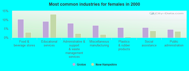
- Food & beverage stores (10.3%)
- Educational services (9.2%)
- Administrative & support & waste management services (8.0%)
- Miscellaneous manufacturing (6.9%)
- Plastics & rubber products (5.7%)
- Social assistance (5.7%)
- Public administration (4.6%)

- Other production occupations, including supervisors (7.0%)
- Metal workers and plastic workers (6.5%)
- Building and grounds cleaning and maintenance occupations (5.6%)
- Art and design workers (5.1%)
- Electrical equipment mechanics and other installation, maintenance, and repair workers, including supervisors (5.1%)
- Fishing, hunting, and forestry occupations (4.7%)
- Carpenters (4.7%)
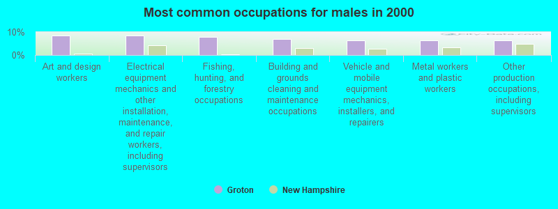
- Art and design workers (8.6%)
- Electrical equipment mechanics and other installation, maintenance, and repair workers, including supervisors (8.6%)
- Fishing, hunting, and forestry occupations (7.8%)
- Building and grounds cleaning and maintenance occupations (7.0%)
- Vehicle and mobile equipment mechanics, installers, and repairers (6.2%)
- Metal workers and plastic workers (6.2%)
- Other production occupations, including supervisors (6.2%)
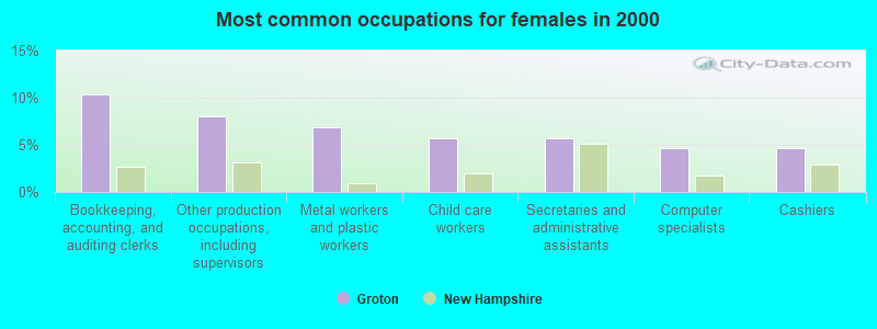
- Bookkeeping, accounting, and auditing clerks (10.3%)
- Other production occupations, including supervisors (8.0%)
- Metal workers and plastic workers (6.9%)
- Child care workers (5.7%)
- Secretaries and administrative assistants (5.7%)
- Computer specialists (4.6%)
- Cashiers (4.6%)
Average climate in Groton, New Hampshire
Based on data reported by over 4,000 weather stations


(lower is better)
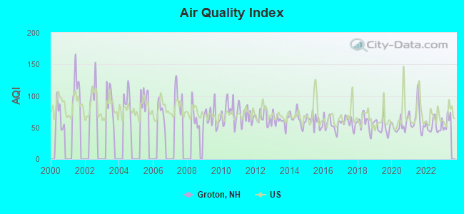
Air Quality Index (AQI) level in 2022 was 52.5. This is better than average.
| City: | 52.5 |
| U.S.: | 72.6 |
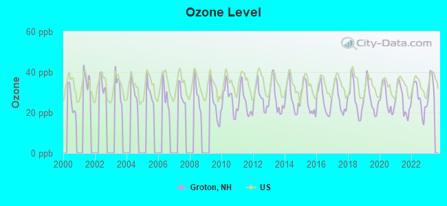
Ozone [ppb] level in 2022 was 26.6. This is better than average. Closest monitor was 5.8 miles away from the city center.
| City: | 26.6 |
| U.S.: | 33.3 |
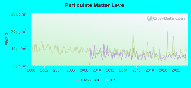
Particulate Matter (PM2.5) [µg/m3] level in 2022 was 5.02. This is significantly better than average. Closest monitor was 9.1 miles away from the city center.
| City: | 5.02 |
| U.S.: | 8.11 |
Tornado activity:
Groton-area historical tornado activity is below New Hampshire state average. It is 68% smaller than the overall U.S. average.
On 5/11/1973, a category F2 (max. wind speeds 113-157 mph) tornado 13.6 miles away from the Groton town center .
On 8/11/1966, a category F2 tornado 20.4 miles away from the town center caused between $50,000 and $500,000 in damages.
Earthquake activity:
Groton-area historical earthquake activity is significantly above New Hampshire state average. It is 71% smaller than the overall U.S. average.On 4/20/2002 at 10:50:47, a magnitude 5.3 (5.3 ML, Depth: 3.0 mi, Class: Moderate, Intensity: VI - VII) earthquake occurred 104.7 miles away from the city center
On 10/7/1983 at 10:18:46, a magnitude 5.3 (5.1 MB, 5.3 LG, 5.1 ML) earthquake occurred 124.1 miles away from the city center
On 4/20/2002 at 10:50:47, a magnitude 5.2 (5.2 MB, 4.2 MS, 5.2 MW, 5.0 MW) earthquake occurred 104.8 miles away from Groton center
On 1/19/1982 at 00:14:42, a magnitude 4.7 (4.5 MB, 4.7 MD, 4.5 LG, Class: Light, Intensity: IV - V) earthquake occurred 22.3 miles away from Groton center
On 10/16/2012 at 23:12:25, a magnitude 4.7 (4.7 ML, Depth: 10.0 mi) earthquake occurred 61.6 miles away from Groton center
On 6/16/1995 at 12:13:11, a magnitude 3.8 (3.8 LG, Depth: 3.1 mi, Class: Light, Intensity: II - III) earthquake occurred 36.6 miles away from Groton center
Magnitude types: regional Lg-wave magnitude (LG), body-wave magnitude (MB), duration magnitude (MD), local magnitude (ML), surface-wave magnitude (MS), moment magnitude (MW)
Natural disasters:
The number of natural disasters in Grafton County (32) is a lot greater than the US average (15).Major Disasters (Presidential) Declared: 20
Emergencies Declared: 9
Causes of natural disasters: Floods: 16, Storms: 16, Hurricanes: 3, Snows: 3, Winter Storms: 3, Tropical Storms: 2, Blizzard: 1, Heavy Rain: 1, Ice Storm: 1, Landslide: 1, Snowfall: 1, Snowstorm: 1, Wind: 1, Other: 1 (Note: some incidents may be assigned to more than one category).

Colleges/universities with over 2000 students nearest to Groton:
- Plymouth State University (about 9 miles; Plymouth, NH; Full-time enrollment: 4,838)
- Dartmouth College (about 22 miles; Hanover, NH; FT enrollment: 6,030)
- NHTI-Concord's Community College (about 41 miles; Concord, NH; FT enrollment: 2,865)
- Norwich University (about 48 miles; Northfield, VT; FT enrollment: 4,221)
- Southern New Hampshire University (about 54 miles; Manchester, NH; FT enrollment: 16,552)
- Saint Anselm College (about 57 miles; Manchester, NH; FT enrollment: 2,059)
- Mount Washington College (about 58 miles; Manchester, NH; FT enrollment: 2,187)
Points of interest:
Notable location: Sculptured Rocks State Wayside Area (A). Display/hide its location on the map
Cemetery: North Groton Cemetery (1). Display/hide its location on the map
Lakes and reservoirs: Little Pond (A), South Branch Baker River Reservoir (B), Spectacle Pond (C). Display/hide their locations on the map
Streams, rivers, and creeks: Hardy Brook (A), Atwell Brook (B). Display/hide their locations on the map
| This town: | 2.3 people |
| New Hampshire: | 2.5 people |
| This town: | 66.4% |
| Whole state: | 66.3% |
| This town: | 8.8% |
| Whole state: | 8.3% |
No gay or lesbian households reported
| This town: | 6.7% |
| Whole state: | 6.5% |
| This town: | 3.4% |
| Whole state: | 2.8% |
| Here: | 9.6 |
| New Hampshire average: | 10.9 |


Graphs represent county-level data. Detailed 2008 Election Results
Religion statistics for Groton, NH (based on Grafton County data)


| Religion | Adherents | Congregations |
|---|---|---|
| Catholic | 9,503 | 12 |
| Mainline Protestant | 7,832 | 57 |
| Evangelical Protestant | 1,494 | 29 |
| Other | 1,320 | 11 |
| None | 68,969 | - |
Food Environment Statistics:
| This county: | 3.87 / 10,000 pop. |
| New Hampshire: | 2.14 / 10,000 pop. |
| Here: | 0.23 / 10,000 pop. |
| New Hampshire: | 0.15 / 10,000 pop. |
| Grafton County: | 1.29 / 10,000 pop. |
| State: | 1.78 / 10,000 pop. |
| This county: | 6.45 / 10,000 pop. |
| State: | 4.02 / 10,000 pop. |
| This county: | 14.41 / 10,000 pop. |
| New Hampshire: | 9.70 / 10,000 pop. |
| This county: | 7.2% |
| State: | 7.6% |
| Here: | 22.9% |
| New Hampshire: | 24.4% |
| Here: | 15.9% |
| New Hampshire: | 15.9% |
Strongest AM radio stations in Groton:
- WPNH (1300 AM; 5 kW; PLYMOUTH, NH; Owner: NORTHEAST COMMUNICATIONS CORPORATION)
- WNTK (1020 AM; 10 kW; NEWPORT, NH; Owner: KOOR COMMUNICATIONS, INC.)
- WRKO (680 AM; 50 kW; BOSTON, MA; Owner: ENTERCOM BOSTON LICENSE, LLC)
- WEZS (1350 AM; 5 kW; LACONIA, NH; Owner: GARY W. HAMMOND)
- WTWN (1100 AM; daytime; 5 kW; WELLS RIVER, VT; Owner: PUFFER BROADCASTING, INC.)
- WCRN (830 AM; 50 kW; WORCESTER, MA; Owner: CARTER BROADCASTING CORPORATION)
- WNNZ (640 AM; 50 kW; WESTFIELD, MA; Owner: CLEAR CHANNEL BROADCASTING LICENSES, INC.)
- WEEI (850 AM; 50 kW; BOSTON, MA; Owner: ENTERCOM BOSTON LICENSE, LLC)
- WKOX (1200 AM; 50 kW; FRAMINGHAM, MA; Owner: CAPSTAR TX LIMITED PARTNERSHIP)
- WGY (810 AM; 50 kW; SCHENECTADY, NY; Owner: CLEAR CHANNEL BROADCASTING LICENSES, INC.)
- WBZ (1030 AM; 50 kW; BOSTON, MA; Owner: INFINITY BROADCASTING OPERATIONS, INC.)
- WCHP (760 AM; 35 kW; CHAMPLAIN, NY; Owner: CHAMPLAIN RADIO, INC.)
- WBIX (1060 AM; 40 kW; NATICK, MA; Owner: LANGER BROADCASTING CORPORATION)
Strongest FM radio stations in Groton:
- WPNH-FM (100.1 FM; PLYMOUTH, NH; Owner: NORTHEAST COMMUNICATIONS CORPORATION)
- WVFM (105.7 FM; CAMPTON, NH; Owner: DEVON BROADCASTING COMPANY, INC.)
- WEVH (91.3 FM; HANOVER, NH; Owner: NEW HAMPSHIRE PUBLIC RADIO INC)
- WSCY (106.9 FM; MOULTONBOROUGH, NH; Owner: NORTHEAST COMMUNICATIONS CORPORATION)
- WPKQ (103.7 FM; NORTH CONWAY, NH; Owner: CITADEL BROADCASTING COMPANY)
- WHOM (94.9 FM; MT. WASHINGTON, NH; Owner: CITADEL BROADCASTING COMPANY)
- WHDQ (106.1 FM; CLAREMONT, NH; Owner: GREAT NORTHERN RADIO, L.L.C.)
- WVPR (89.5 FM; WINDSOR, VT; Owner: VERMONT PUBLIC RADIO)
- WJJR (98.1 FM; RUTLAND, VT; Owner: 6 JOHNSON ROAD LICENSES, INC.)
- WZRT (97.1 FM; RUTLAND, VT; Owner: CAPSTAR TX LIMITED PARTNERSHIP)
- WEBK (105.3 FM; KILLINGTON, VT; Owner: 6 JOHNSON ROAD LICENSES, INC.)
- WGLV (91.7 FM; WOODSTOCK, VT; Owner: CHRISTIAN MINISTRIES INC)
- WHDQ-FM1 (106.1 FM; RUTLAND, VT; Owner: GREAT NORTHERN RADIO, L.L.C.)
- WLKZ (104.9 FM; WOLFEBORO, NH; Owner: TELE-MEDIA COMPANY OF NEW HAMPSHIRE, L.L.C.)
- WNHI (93.3 FM; BELMONT, NH; Owner: CONCORD BROADCASTING, L.L.C.)
- WNTK-FM (99.7 FM; NEW LONDON, NH; Owner: SHEILA E. VINIKOOR)
- WXXK (100.5 FM; LEBANON, NH; Owner: CAPSTAR TX LIMITED PARTNERSHIP)
- WVRR (101.7 FM; NEWPORT, NH; Owner: CAPSTAR TX LIMITED PARTNERSHIP)
- WDEV-FM (96.1 FM; WARREN, VT; Owner: RADIO VERMONT, INC.)
- WCVT (101.7 FM; STOWE, VT; Owner: RADIO VERMONT CLASSICS, L.L.C.)
TV broadcast stations around Groton:
- W15BK (Channel 15; HANOVER, NH; Owner: UNIVERSITY OF NEW HAMPSHIRE)
- WMTW-TV (Channel 8; POLAND SPRING, ME; Owner: WMTW BROADCAST GROUP, LLC)
Groton fatal accident list:
- National Bridge Inventory (NBI) Statistics
- 3Number of bridges
- 13ft / 3.6mTotal length
- $9,426,000Total costs
- 694Total average daily traffic
- 64Total average daily truck traffic
- 1,025Total future (year 2042) average daily traffic
FCC Registered Broadcast Land Mobile Towers:
1- Tenney Mountain (Lat: 43.743056 Lon: -71.795000), Type: Tower, Structure height: 55 m, Overall height: 56 m, Call Sign: WQJZ625,
Assigned Frequencies: 155.850 MHz, Grant Date: 12/18/2018, Expiration Date: 02/25/2029, Certifier: Thomas Andross, Registrant: Grafton County Sheriff, 3785 Dartnouth College Hwy, North Haverhill, NH 03774-4936, Phone: (603) 787-2111, Fax: (603) 787-2005, Email:
FCC Registered Microwave Towers:
4- Tenney Mt Summet, Summit Of Tenney Mountain (Lat: 43.739167 Lon: -71.790278), Type: Tower, Structure height: 54.9 m, Call Sign: WPOM933,
Assigned Frequencies: 948.000 MHz, Grant Date: 03/17/2000, Expiration Date: 04/01/2030, Certifier: Dennis F Begley, Registrant: Reddy Begley & Mccormick, 2175 K St. Nw, Suite 350, Washington, DC 20037, Phone: (202) 659-5700, Fax: (202) 659-5711, Email:
- TENNEY MTN, Tenney Mountain Sky Area (Lat: 43.739194 Lon: -71.790056), Type: Tower, Structure height: 54.8 m, Overall height: 60.9 m, Call Sign: WPQN964,
Assigned Frequencies: 6838.75 MHz, Grant Date: 06/16/2020, Expiration Date: 07/10/2030, Certifier: James R Kowalik, Registrant: Nh Dept. Of Safety/Emergency Services And Communications, 33 Hazen Dr (Mailing), Concord, NH 03305, Phone: (603) 528-7541, Fax: (603) 271-6629, Email:
- Tenney Mountain Summ, Summit Of Tenney Mountain (Lat: 43.739167 Lon: -71.790833), Type: Tower, Structure height: 54.9 m, Call Sign: WPQP681,
Assigned Frequencies: 945.500 MHz, Grant Date: 08/04/2000, Expiration Date: 04/01/2030, Certifier: Dennis F Begley, Registrant: Reddy Begley & Mccormick, Suite 350, 1001 22nd Street, N. W., Washington, DC 20037-1803, Phone: (202) 659-5700, Fax: (202) 659-5711
- TENNEY MTN, Tenney Mountain Road (Lat: 43.739222 Lon: -71.790083), Type: Ltower, Structure height: 56 m, Call Sign: WQMI773,
Assigned Frequencies: 11245.0 MHz, 11325.0 MHz, 11245.0 MHz, 11325.0 MHz, 11245.0 MHz, 11325.0 MHz, 11245.0 MHz, 11325.0 MHz, 11245.0 MHz, 11325.0 MHz... (+6 more), Grant Date: 07/22/2020, Expiration Date: 08/18/2030, Certifier: Dena Delucca, Registrant: New Hampshire Electric Cooperative, 579 Tenney Mountain Highway, Plymouth, NH 03264, Phone: (603) 536-1800, Email:
FCC Registered Paging Towers:
3- Tenney Mountain (Lat: 43.743056 Lon: -71.795000), Type: Pole, Structure height: 50 m, Call Sign: WPOL510,
Assigned Frequencies: 152.630 MHz, Grant Date: 11/19/2019, Expiration Date: 12/10/2029, Certifier: Fred Booth, Registrant: Nh Dept Of Safety, 39 Hazen Dr, Concord, NH 03305, Phone: (603) 271-2421, Fax: (603) 271-6629, Email:
- Tenney Mountain (Lat: 43.736167 Lon: -71.793667), Call Sign: KCI295,
Assigned Frequencies: 43.2200 MHz, Grant Date: 05/11/1999, Expiration Date: 04/01/2009, Cancellation Date: 12/02/2003, Certifier: Paul H Kuzia, Registrant: Wilkinson Barker Knauer, LLP, 2300 N Street, N.W., 7th Floor, Washington, DC 20037, Phone: (202) 783-4141, Fax: (202) 783-5851, Email:
- Tenney Mountain (Lat: 43.739361 Lon: -71.790028), Type: Tower, Structure height: 54.9 m, Overall height: 61 m, Call Sign: KNKG819, Licensee ID: L01422065,
Assigned Frequencies: 931.862 MHz, Grant Date: 08/12/2008, Expiration Date: 07/01/2018, Cancellation Date: 01/28/2014, Certifier: Shawn E Endsley, Registrant: Usa Mobility Wireless, Inc., 3000 Technology Dr. #400, Plano, TX 75074, Phone: (972) 801-0000, Fax: (972) 801-1699, Email:
FCC Registered Amateur Radio Licenses:
1- Call Sign: W2GIK, Licensee ID: L01191116, Grant Date: 09/12/2006, Expiration Date: 09/12/2016, Cancellation Date: 09/13/2018, Registrant: Richard E O Connor, 21 Halls Brook Rd, Groton, NH 03266
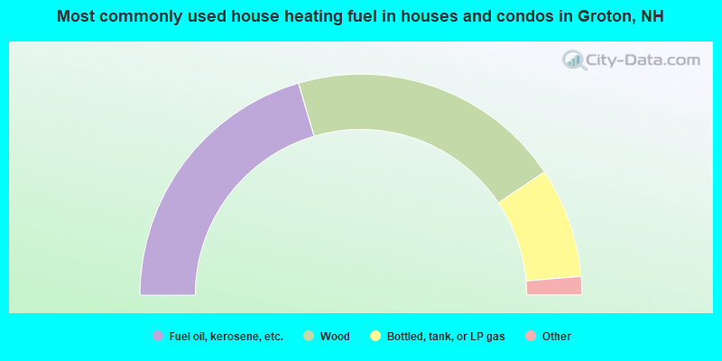
- 40.9%Fuel oil, kerosene, etc.
- 40.3%Wood
- 16.1%Bottled, tank, or LP gas
- 1.3%Utility gas
- 1.3%Electricity
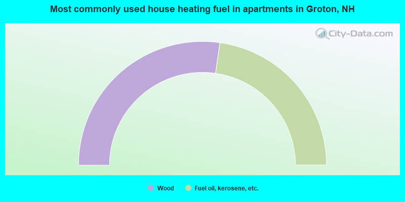
- 54.5%Wood
- 45.5%Fuel oil, kerosene, etc.
Groton compared to New Hampshire state average:
- Unemployed percentage significantly below state average.
- Black race population percentage significantly below state average.
- Hispanic race population percentage significantly below state average.
- Median age above state average.
- Foreign-born population percentage below state average.
- Renting percentage significantly below state average.
- Length of stay since moving in significantly above state average.
- Number of rooms per house significantly below state average.
- House age significantly below state average.
- Number of college students below state average.
- Percentage of population with a bachelor's degree or higher significantly below state average.