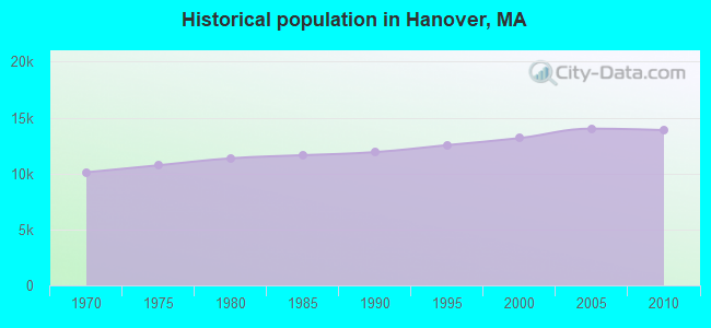
Hanover, Massachusetts
Submit your own pictures of this town and show them to the world
- OSM Map
- General Map
- Google Map
- MSN Map
Population change since 2000: +5.4%
 |
| Males: 6,775 | |
| Females: 7,104 |
| Median resident age: | 41.8 years |
| Massachusetts median age: | 39.2 years |
Zip codes: 02339.
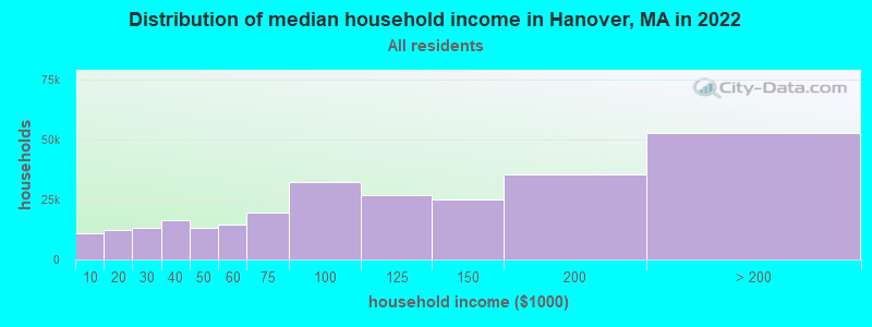
| Hanover: | $136,979 |
| MA: | $94,488 |
Estimated per capita income in 2022: $66,134 (it was $30,268 in 2000)
Hanover town income, earnings, and wages data
Estimated median house or condo value in 2022: $794,130 (it was $255,000 in 2000)
| Hanover: | $794,130 |
| MA: | $534,700 |
Mean prices in 2022: all housing units: $585,203; detached houses: $620,100; townhouses or other attached units: $487,972; in 2-unit structures: $464,355; in 3-to-4-unit structures: $429,583; in 5-or-more-unit structures: $438,441; mobile homes: $207,706; occupied boats, rvs, vans, etc.: $17,153
Detailed information about poverty and poor residents in Hanover, MA


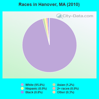
- 13,30095.8%White alone
- 1601.2%Asian alone
- 1210.9%Two or more races
- 1280.9%Hispanic
- 1060.8%Black alone
- 470.3%Other race alone
- 130.09%American Indian alone
- 40.03%Native Hawaiian and Other
Pacific Islander alone
Races in Hanover detailed stats: ancestries, foreign born residents, place of birth
According to our research of Massachusetts and other state lists, there were 2 registered sex offenders living in Hanover, Massachusetts as of April 24, 2024.
The ratio of all residents to sex offenders in Hanover is 6,940 to 1.
The ratio of registered sex offenders to all residents in this city is much lower than the state average.
Type |
2009 |
2010 |
2011 |
2012 |
2013 |
2014 |
2015 |
2016 |
2017 |
2018 |
2019 |
2020 |
2021 |
2022 |
|---|---|---|---|---|---|---|---|---|---|---|---|---|---|---|
| Murders (per 100,000) | 0 (0.0) | 0 (0.0) | 0 (0.0) | 0 (0.0) | 0 (0.0) | 0 (0.0) | 0 (0.0) | 0 (0.0) | 0 (0.0) | 0 (0.0) | 0 (0.0) | 0 (0.0) | 0 (0.0) | 0 (0.0) |
| Rapes (per 100,000) | 0 (0.0) | 0 (0.0) | 0 (0.0) | 0 (0.0) | 2 (14.0) | 0 (0.0) | 1 (6.9) | 0 (0.0) | 0 (0.0) | 1 (6.9) | 0 (0.0) | 0 (0.0) | 2 (13.0) | 3 (19.3) |
| Robberies (per 100,000) | 1 (7.0) | 2 (14.4) | 1 (7.2) | 1 (7.1) | 0 (0.0) | 1 (6.9) | 0 (0.0) | 0 (0.0) | 0 (0.0) | 0 (0.0) | 0 (0.0) | 1 (6.6) | 0 (0.0) | 1 (6.4) |
| Assaults (per 100,000) | 3 (21.1) | 3 (21.6) | 1 (7.2) | 2 (14.2) | 0 (0.0) | 3 (20.8) | 0 (0.0) | 3 (20.7) | 5 (34.3) | 1 (6.9) | 3 (20.7) | 1 (6.6) | 3 (19.5) | 23 (147.6) |
| Burglaries (per 100,000) | 47 (331.3) | 37 (266.6) | 27 (193.4) | 36 (255.7) | 34 (238.2) | 14 (97.1) | 14 (96.7) | 21 (145.2) | 10 (68.5) | 6 (41.3) | 4 (27.6) | 3 (19.8) | 7 (45.5) | 5 (32.1) |
| Thefts (per 100,000) | 354 (2,496) | 281 (2,025) | 249 (1,783) | 230 (1,634) | 171 (1,198) | 171 (1,186) | 134 (925.3) | 92 (636.0) | 82 (561.8) | 110 (757.5) | 116 (800.8) | 46 (303.8) | 39 (253.3) | 58 (372.3) |
| Auto thefts (per 100,000) | 5 (35.2) | 6 (43.2) | 3 (21.5) | 2 (14.2) | 6 (42.0) | 4 (27.7) | 3 (20.7) | 2 (13.8) | 7 (48.0) | 4 (27.5) | 1 (6.9) | 1 (6.6) | 4 (26.0) | 6 (38.5) |
| Arson (per 100,000) | 1 (7.0) | 0 (0.0) | 0 (0.0) | 0 (0.0) | 0 (0.0) | 0 (0.0) | 0 (0.0) | 0 (0.0) | 1 (6.9) | 0 (0.0) | 0 (0.0) | 0 (0.0) | 0 (0.0) | 0 (0.0) |
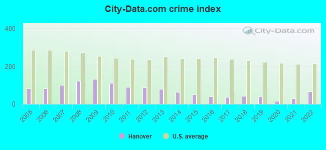
| City-Data.com crime index | 132.2 | 111.8 | 90.2 | 89.4 | 79.2 | 62.7 | 51.0 | 40.9 | 38.0 | 42.3 | 38.7 | 17.4 | 29.7 | 67.1 |
The City-Data.com crime index weighs serious crimes and violent crimes more heavily. Higher means more crime, U.S. average is 246.1. It adjusts for the number of visitors and daily workers commuting into cities.
Crime rate in Hanover detailed stats: murders, rapes, robberies, assaults, burglaries, thefts, arson
Full-time law enforcement employees in 2021, including police officers: 36 (29 officers - 28 male; 1 female).
| Officers per 1,000 residents here: | 1.88 |
| Massachusetts average: | 2.53 |
 Recent articles from our blog. Our writers, many of them Ph.D. graduates or candidates, create easy-to-read articles on a wide variety of topics.


 | Hanover High School Fires Teacher Over Conservative TikTok (57 replies) |
| Norwell, Cohasset, Scituate or Hanover? (26 replies) |
| People are leaving Massachusetts in droves. Who are they? (117 replies) |
| 2023 Real Estate Observations (5278 replies) |
| Nightlife in Boston (261 replies) |
| Towns similar to Hanover? (16 replies) |
Latest news from Hanover, MA collected exclusively by city-data.com from local newspapers, TV, and radio stations
Ancestries: Irish (39.6%), Italian (18.0%), English (16.9%), German (6.2%), French (5.6%), United States (5.1%).
Current Local Time: EST time zone
Incorporated in 1727
Elevation: 60 feet
Land area: 15.6 square miles.
Population density: 889 people per square mile (low).
328 residents are foreign born (1.2% Europe, 0.7% Asia, 0.4% North America).
| This town: | 2.5% |
| Massachusetts: | 12.2% |
| Hanover town: | 1.4% ($3,542) |
| Massachusetts: | 1.3% ($2,336) |
Nearest city with pop. 50,000+: Weymouth, MA  (7.0 miles , pop. 53,988).
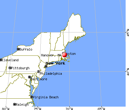
Nearest city with pop. 200,000+: Boston, MA (17.8 miles , pop. 589,141).
Nearest city with pop. 1,000,000+: Bronx, NY (179.6 miles , pop. 1,332,650).
Nearest cities:
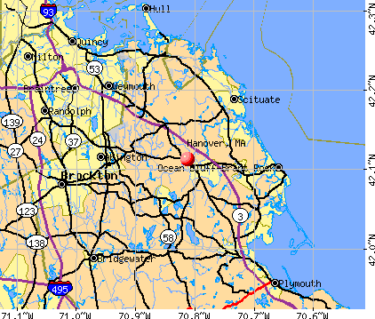
), ), )Latitude: 42.13 N, Longitude: 70.86 W
Area codes: 781, 339

Hanover tourist attractions:
Hanover, Massachusetts accommodation & food services, waste management - Economy and Business Data
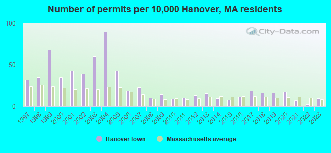
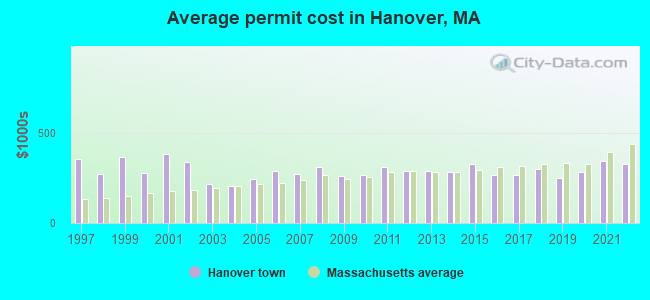
Single-family new house construction building permits:
- 2022: 3 buildings, average cost: $325,000
- 2021: 9 buildings, average cost: $343,900
- 2020: 23 buildings, average cost: $282,400
- 2019: 21 buildings, average cost: $247,900
- 2018: 21 buildings, average cost: $297,900
- 2017: 24 buildings, average cost: $268,200
- 2016: 15 buildings, average cost: $263,500
- 2015: 10 buildings, average cost: $327,200
- 2014: 12 buildings, average cost: $280,100
- 2013: 20 buildings, average cost: $285,000
- 2012: 17 buildings, average cost: $289,500
- 2011: 13 buildings, average cost: $311,200
- 2010: 11 buildings, average cost: $268,300
- 2009: 19 buildings, average cost: $257,900
- 2008: 13 buildings, average cost: $310,500
- 2007: 30 buildings, average cost: $273,400
- 2006: 24 buildings, average cost: $286,700
- 2005: 56 buildings, average cost: $245,400
- 2004: 119 buildings, average cost: $207,200
- 2003: 80 buildings, average cost: $217,600
- 2002: 51 buildings, average cost: $336,000
- 2001: 56 buildings, average cost: $381,600
- 2000: 46 buildings, average cost: $278,500
- 1999: 89 buildings, average cost: $362,800
- 1998: 46 buildings, average cost: $269,100
- 1997: 42 buildings, average cost: $353,400
| Here: | 2.8% |
| Massachusetts: | 3.5% |
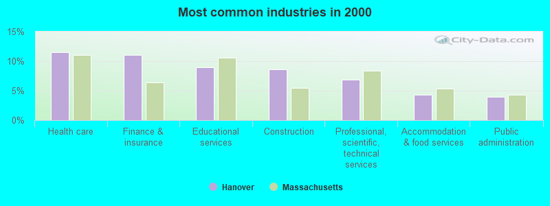
- Health care (11.5%)
- Finance & insurance (11.0%)
- Educational services (8.9%)
- Construction (8.6%)
- Professional, scientific, technical services (6.9%)
- Accommodation & food services (4.3%)
- Public administration (4.0%)
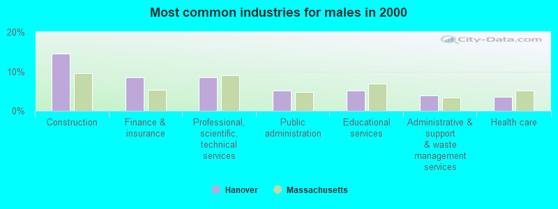
- Construction (14.5%)
- Finance & insurance (8.5%)
- Professional, scientific, technical services (8.4%)
- Public administration (5.1%)
- Educational services (5.1%)
- Administrative & support & waste management services (3.9%)
- Health care (3.6%)
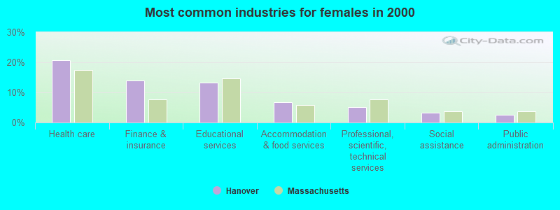
- Health care (20.7%)
- Finance & insurance (13.9%)
- Educational services (13.3%)
- Accommodation & food services (6.8%)
- Professional, scientific, technical services (5.1%)
- Social assistance (3.3%)
- Public administration (2.7%)
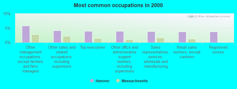
- Other management occupations, except farmers and farm managers (5.8%)
- Other sales and related occupations, including supervisors (4.2%)
- Top executives (4.0%)
- Other office and administrative support workers, including supervisors (3.9%)
- Sales representatives, services, wholesale and manufacturing (3.8%)
- Retail sales workers, except cashiers (3.7%)
- Registered nurses (3.7%)
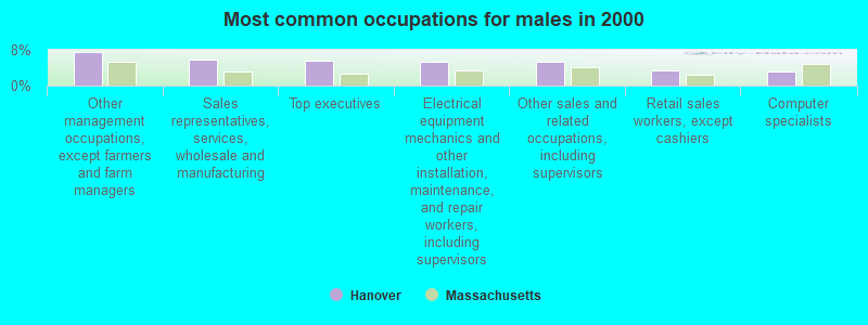
- Other management occupations, except farmers and farm managers (7.5%)
- Sales representatives, services, wholesale and manufacturing (5.8%)
- Top executives (5.6%)
- Electrical equipment mechanics and other installation, maintenance, and repair workers, including supervisors (5.4%)
- Other sales and related occupations, including supervisors (5.4%)
- Retail sales workers, except cashiers (3.5%)
- Computer specialists (3.2%)
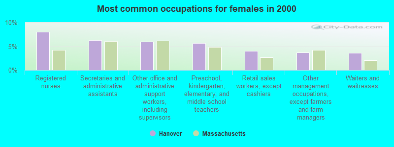
- Registered nurses (8.0%)
- Secretaries and administrative assistants (6.3%)
- Other office and administrative support workers, including supervisors (6.0%)
- Preschool, kindergarten, elementary, and middle school teachers (5.7%)
- Retail sales workers, except cashiers (4.0%)
- Other management occupations, except farmers and farm managers (3.7%)
- Waiters and waitresses (3.6%)
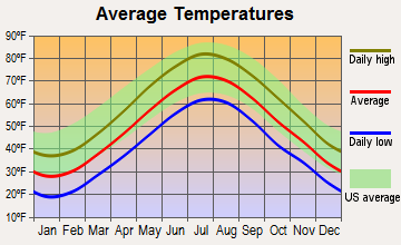
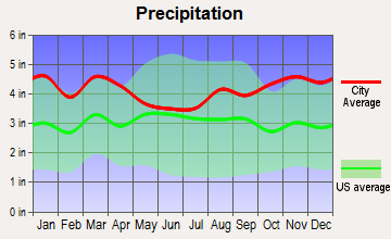
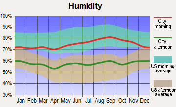
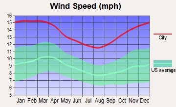
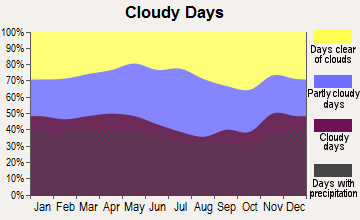
Average climate in Hanover, Massachusetts
Based on data reported by over 4,000 weather stations
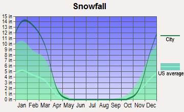
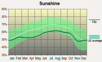
(lower is better)
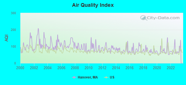
Air Quality Index (AQI) level in 2022 was 74.3. This is about average.
| City: | 74.3 |
| U.S.: | 72.6 |
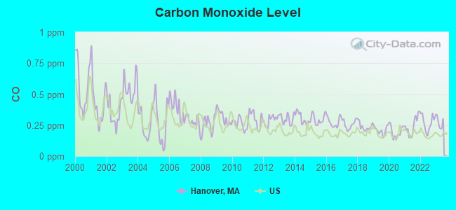
Carbon Monoxide (CO) [ppm] level in 2022 was 0.270. This is about average. Closest monitor was 9.9 miles away from the city center.
| City: | 0.270 |
| U.S.: | 0.251 |
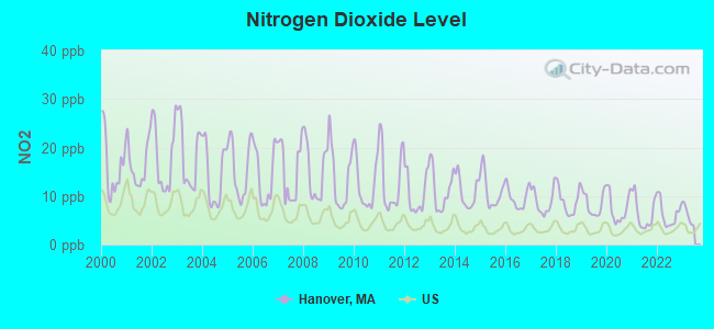
Nitrogen Dioxide (NO2) [ppb] level in 2022 was 6.25. This is worse than average. Closest monitor was 9.4 miles away from the city center.
| City: | 6.25 |
| U.S.: | 5.11 |
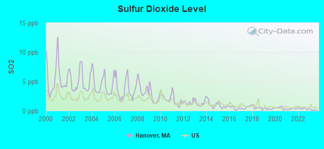
Sulfur Dioxide (SO2) [ppb] level in 2022 was 0.358. This is significantly better than average. Closest monitor was 8.7 miles away from the city center.
| City: | 0.358 |
| U.S.: | 1.515 |
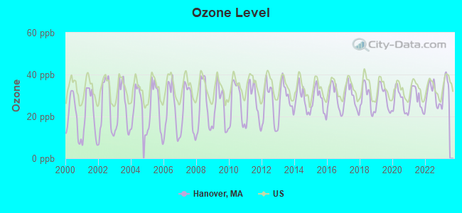
Ozone [ppb] level in 2022 was 30.5. This is about average. Closest monitor was 9.0 miles away from the city center.
| City: | 30.5 |
| U.S.: | 33.3 |
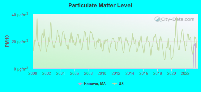
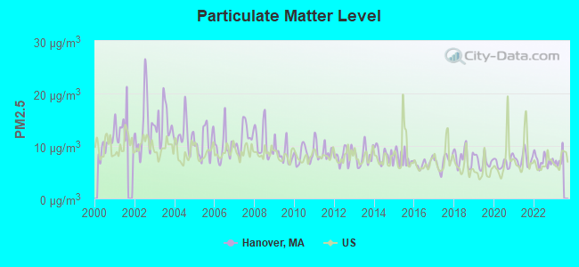
Particulate Matter (PM2.5) [µg/m3] level in 2022 was 7.22. This is about average. Closest monitor was 8.6 miles away from the city center.
| City: | 7.22 |
| U.S.: | 8.11 |
Tornado activity:
Hanover-area historical tornado activity is below Massachusetts state average. It is 58% smaller than the overall U.S. average.
On 6/9/1953, a category F4 (max. wind speeds 207-260 mph) tornado 35.9 miles away from the Hanover town center killed 90 people and injured 1228 people and caused between $50,000,000 and $500,000,000 in damages.
On 6/9/1953, a category F3 (max. wind speeds 158-206 mph) tornado 18.3 miles away from the town center injured 17 people and caused between $500,000 and $5,000,000 in damages.
Earthquake activity:
Hanover-area historical earthquake activity is significantly above Massachusetts state average. It is 74% smaller than the overall U.S. average.On 10/7/1983 at 10:18:46, a magnitude 5.3 (5.1 MB, 5.3 LG, 5.1 ML, Class: Moderate, Intensity: VI - VII) earthquake occurred 216.6 miles away from Hanover center
On 4/20/2002 at 10:50:47, a magnitude 5.3 (5.3 ML, Depth: 3.0 mi) earthquake occurred 218.1 miles away from the city center
On 1/19/1982 at 00:14:42, a magnitude 4.7 (4.5 MB, 4.7 MD, 4.5 LG, Class: Light, Intensity: IV - V) earthquake occurred 102.0 miles away from the city center
On 10/16/2012 at 23:12:25, a magnitude 4.7 (4.7 ML, Depth: 10.0 mi) earthquake occurred 102.1 miles away from Hanover center
On 4/20/2002 at 10:50:47, a magnitude 5.2 (5.2 MB, 4.2 MS, 5.2 MW, 5.0 MW) earthquake occurred 217.5 miles away from Hanover center
On 8/22/1992 at 12:20:32, a magnitude 4.8 (4.8 MB, 3.8 MS, 4.7 LG, Depth: 6.2 mi) earthquake occurred 211.0 miles away from Hanover center
Magnitude types: regional Lg-wave magnitude (LG), body-wave magnitude (MB), duration magnitude (MD), local magnitude (ML), surface-wave magnitude (MS), moment magnitude (MW)
Natural disasters:
The number of natural disasters in Plymouth County (26) is a lot greater than the US average (15).Major Disasters (Presidential) Declared: 17
Emergencies Declared: 9
Causes of natural disasters: Floods: 11, Storms: 9, Hurricanes: 7, Snows: 3, Snowstorms: 3, Blizzards: 2, Winter Storms: 2, Heavy Rain: 1, Snowfall: 1, Tropical Storm: 1, Wind: 1 (Note: some incidents may be assigned to more than one category).
Hospitals and medical centers near Hanover:
- NORWELL VNA INC (Home Health Center, about 3 miles away; NORWELL, MA)
- NORWELL KNOLL NURSING HOME (Nursing Home, about 3 miles away; NORWELL, MA)
- SOUTHWOOD AT NORWELL NURSING CTR (Nursing Home, about 3 miles away; NORWELL, MA)
- COYNE HEALTHCARE CENTER (Nursing Home, about 3 miles away; ROCKLAND, MA)
- DEL-MANOR N H (Nursing Home, about 3 miles away; ROCKLAND, MA)
- ROCKLAND NURSING HOME (Nursing Home, about 3 miles away; ROCKLAND, MA)
- STETSON MANOR NURSING HOME (Nursing Home, about 4 miles away; NORWELL, MA)
Heliports located in Hanover:
Amtrak stations near Hanover:
- 16 miles: ROUTE 128 (WESTWOOD, UNIVERSITY AVE. & RTE. 128) . Services: ticket office, enclosed waiting area, public restrooms, public payphones, vending machines, paid short-term parking, taxi stand, public transit connection.
- 19 miles: BOSTON (SO. STA) (BOSTON, ATLANTIC AVE. & SUMMER ST.) . Services: ticket office, fully wheelchair accessible, enclosed waiting area, public restrooms, public payphones, full-service food facilities and snack bar, ATM, paid short-term parking, paid long-term parking, call for car rental service, taxi stand, intercity bus service, public transit connection.
- 19 miles: BACK BAY (BOSTON, 145 DARTMOUTH ST.) . Services: ticket office, partially wheelchair accessible, enclosed waiting area, public restrooms, public payphones, vending machines, ATM, paid short-term parking, paid long-term parking, call for car rental service, taxi stand, public transit connection.
Operable nuclear power plant near Hanover:
- 16 miles: Pilgrim in Plymouth, MA.
Colleges/universities with over 2000 students nearest to Hanover:
- Massasoit Community College (about 8 miles; Brockton, MA; Full-time enrollment: 5,442)
- Bridgewater State University (about 12 miles; Bridgewater, MA; FT enrollment: 9,802)
- Quincy College (about 12 miles; Quincy, MA; FT enrollment: 3,184)
- Stonehill College (about 13 miles; Easton, MA; FT enrollment: 2,563)
- Curry College (about 16 miles; Milton, MA; FT enrollment: 2,586)
- University of Massachusetts-Boston (about 16 miles; Boston, MA; FT enrollment: 12,625)
- Northeastern University (about 19 miles; Boston, MA; FT enrollment: 27,758)
Public high schools in Hanover:
- HANOVER HIGH (Students: 719, Location: 287 CEDAR STREET, Grades: 9-12)
- SO SHORE VOCATIONAL TECHNICAL HIGH (Students: 592, Location: 476 WEBSTER STREET, Grades: 9-12)
Public elementary/middle schools in Hanover:
- HANOVER MIDDLE (Students: 894, Location: 45 WHITING STREET, Grades: 5-8)
- CEDAR ELEMENTARY (Students: 557, Location: 265 CEDAR STREET, Grades: PK-4)
- CENTER ELEMENTARY (Students: 374, Location: 65 SILVER STREET, Grades: KG-2)
- SYLVESTER (Students: 249, Location: 495 HANOVER STREET, Grades: 3-4)
Library in Hanover:
Points of interest:
Notable locations in Hanover: Hanover Square (A), Hanover Plaza (B), Hanover Fire Department Station 1 (C), Hanover Fire Department Station 2 (D), Hanover Fire Department Station 3 (E), Hanover Fire Department Station 4 Headquarters (F), Hanover Fire Station (G), Hanover Town Hall (H), John Curtis Free Library (I). Display/hide their locations on the map
Shopping Centers: Tedeschi Shopping Center (1), Hanover Mall Shopping Center (2), Merchants Row Shopping Center (3). Display/hide their locations on the map
Churches in Hanover include: Saint Andrews Episcopal Church (A), Lutheran Church of the Cross (B), First Congregational Church (C), First Baptist Church of Hanover (D). Display/hide their locations on the map
Cemeteries: Hanover Center Cemetery (1), Magoun Cemetery (2), Hanover Cemetery (3). Display/hide their locations on the map
Lakes, reservoirs, and swamps: Shinglemill Pond (A), Mill Pond (B), Tindale Pond (C), Hackett Pond (D), Forge Pond (E), Indian Head River Reservoir (F), Wampum Swamp (G), Old Pond Meadows (H). Display/hide their locations on the map
Streams, rivers, and creeks: French Stream (A), Cushing Brook (B), Ben Mann Brook (C), Wildcat Brook (D), Shinglemill Brook (E), Torrey Brook (F), Longwater Brook (G), Mollys Brook (H), Iron Mine Brook (I). Display/hide their locations on the map
Tourist attractions: Hanover Historical Society (Cultural Attractions- Events- & Facilities; 514 Hanover Street), Big Top Playland (Amusement & Theme Parks; Hanover Mall), Star Land Sports & Fun Park (Amusement & Theme Parks; 645 Washington Street).
Hotel: Linchris Hotel Corporation (269 Hanover Street # 2).
Birthplace of: Doug Smith (author) - Ice hockey player.
Drinking water stations with addresses in Hanover and their reported violations in the past:
HANOVER WATER DEPT (Population served: 13,879, Groundwater):Past health violations:
- MCL, Acute (TCR) - In SEP-2011, Contaminant: Coliform. Follow-up actions: St AO (w/o penalty) issued (NOV-29-2011), St Compliance achieved (DEC-23-2011)
- MCL, Monthly (TCR) - In SEP-2011, Contaminant: Coliform. Follow-up actions: St AO (w/o penalty) issued (NOV-29-2011), St Compliance achieved (DEC-23-2011)
- MCL, Monthly (TCR) - In NOV-2010, Contaminant: Coliform. Follow-up actions: St AO (w/o penalty) issued (FEB-18-2011), St Compliance achieved (FEB-18-2011)
| This town: | 2.9 people |
| Massachusetts: | 2.5 people |
| This town: | 79.4% |
| Whole state: | 63.0% |
| This town: | 3.4% |
| Whole state: | 7.0% |
Likely homosexual households (counted as self-reported same-sex unmarried-partner households)
- Lesbian couples: 0.3% of all households
- Gay men: 0.5% of all households
| This town: | 2.3% |
| Whole state: | 9.3% |
| This town: | 0.7% |
| Whole state: | 4.4% |
People in group quarters in Hanover in 2010:
- 77 people in residential schools for people with disabilities
- 18 people in group homes intended for adults
- 3 people in other noninstitutional facilities
Banks with branches in Hanover (2011 data):
- Rockland Trust Company: Hanover Branch at 272 Columbia Road, branch established on 1957/10/28. Info updated 2009/05/20: Bank assets: $4,974.4 mil, Deposits: $3,903.9 mil, headquarters in Rockland, MA, positive income, Commercial Lending Specialization, 67 total offices, Holding Company: Independent Bank Corp.
- RBS Citizens, National Association: Hanover Branch at 250 Rockland Street, branch established on 1956/05/01. Info updated 2007/09/19: Bank assets: $106,940.6 mil, Deposits: $75,690.2 mil, headquarters in Providence, RI, positive income, 1135 total offices, Holding Company: Uk Financial Investments Limited
- Hingham Institution for Savings: Norwell Branch at 5 Assinippi Avenue, branch established on 2008/06/23. Info updated 2006/12/01: Bank assets: $1,127.3 mil, Deposits: $790.5 mil, headquarters in Hingham, MA, positive income, Commercial Lending Specialization, 11 total offices
- S-Bank: Hanover Branch at 1165 Washington Street, branch established on 2010/02/11. Info updated 2009/09/25: Bank assets: $214.7 mil, Deposits: $183.5 mil, headquarters in Weymouth, MA, positive income, Mortgage Lending Specialization, 4 total offices, Holding Company: South Shore Mutual Holding Company
- Bank of America, National Association: Hanover Washington Street Branch at 1764 Washington Street, branch established on 1988/12/12. Info updated 2009/11/18: Bank assets: $1,451,969.3 mil, Deposits: $1,077,176.8 mil, headquarters in Charlotte, NC, positive income, 5782 total offices, Holding Company: Bank Of America Corporation
- Sovereign Bank, National Association: Columbia Road Branch at 303 Columbia Road, branch established on 2001/07/16. Info updated 2012/01/31: Bank assets: $78,146.9 mil, Deposits: $48,042.9 mil, headquarters in Wilmington, DE, positive income, Commercial Lending Specialization, 718 total offices, Holding Company: Banco Santander, S.A.
For population 15 years and over in Hanover:
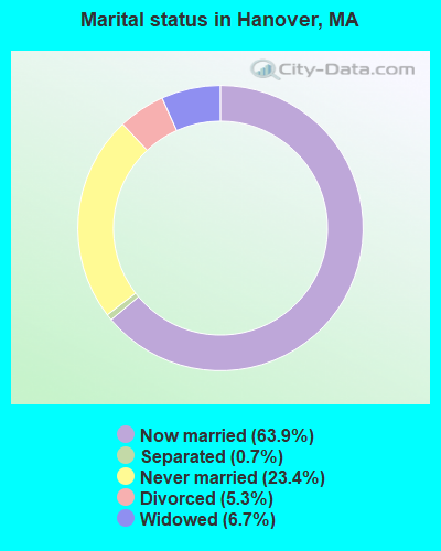
- Never married: 23.4%
- Now married: 63.9%
- Separated: 0.7%
- Widowed: 6.7%
- Divorced: 5.3%
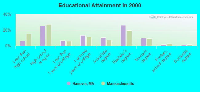
For population 25 years and over in Hanover:
- High school or higher: 93.8%
- Bachelor's degree or higher: 38.3%
- Graduate or professional degree: 12.1%
- Unemployed: 2.9%
- Mean travel time to work (commute): 31.5 minutes
| Here: | 9.2 |
| Massachusetts average: | 13.1 |


Graphs represent county-level data. Detailed 2008 Election Results
Religion statistics for Hanover, MA (based on Plymouth County data)


| Religion | Adherents | Congregations |
|---|---|---|
| Catholic | 165,985 | 35 |
| Mainline Protestant | 23,724 | 91 |
| Evangelical Protestant | 13,159 | 96 |
| Other | 6,129 | 43 |
| Orthodox | 1,140 | 3 |
| Black Protestant | 611 | 5 |
| None | 284,171 | - |
Food Environment Statistics:
| Plymouth County: | 1.74 / 10,000 pop. |
| State: | 1.98 / 10,000 pop. |
| Plymouth County: | 0.04 / 10,000 pop. |
| Massachusetts: | 0.05 / 10,000 pop. |
| This county: | 2.84 / 10,000 pop. |
| Massachusetts: | 2.22 / 10,000 pop. |
| Plymouth County: | 2.20 / 10,000 pop. |
| State: | 1.77 / 10,000 pop. |
| This county: | 7.37 / 10,000 pop. |
| Massachusetts: | 8.76 / 10,000 pop. |
| Plymouth County: | 7.9% |
| Massachusetts: | 8.1% |
| This county: | 21.7% |
| State: | 22.5% |
| Plymouth County: | 16.3% |
| Massachusetts: | 16.5% |
5.54% of this county's 2020 resident taxpayers moved to other counties in 2021 ($85,482 average adjusted gross income)
| Here: | 5.54% |
| Massachusetts average: | 7.18% |
0.01% of residents moved to foreign countries ($80 average AGI)
Plymouth County: 0.01% Massachusetts average: 0.02%
Top counties to which taxpayers relocated from this county between 2020 and 2021:
| to Bristol County, MA | |
| to Norfolk County, MA | |
| to Suffolk County, MA |
| Businesses in Hanover, MA | ||||
| Name | Count | Name | Count | |
|---|---|---|---|---|
| AT&T | 1 | OfficeMax | 1 | |
| Ace Hardware | 1 | Old Navy | 1 | |
| Advance Auto Parts | 1 | Outback | 1 | |
| Aeropostale | 1 | Outback Steakhouse | 1 | |
| AutoZone | 1 | Panera Bread | 1 | |
| Bath & Body Works | 1 | Payless | 1 | |
| Burger King | 1 | Penske | 1 | |
| CVS | 1 | PetSmart | 1 | |
| Casual Male XL | 1 | Pier 1 Imports | 1 | |
| Charlotte Russe | 1 | RadioShack | 1 | |
| Dairy Queen | 1 | Sears | 2 | |
| Deb | 1 | Shaw's | 1 | |
| Dunkin Donuts | 5 | Spencer Gifts | 1 | |
| Famous Footwear | 1 | Sprint Nextel | 1 | |
| FedEx | 6 | Starbucks | 2 | |
| Foot Locker | 1 | Subaru | 1 | |
| Ford | 1 | Subway | 1 | |
| GNC | 1 | T-Mobile | 2 | |
| GameStop | 2 | Target | 1 | |
| Goodwill | 1 | The Limited | 1 | |
| H&R Block | 1 | Toyota | 1 | |
| JCPenney | 1 | Toys"R"Us | 1 | |
| Jones New York | 2 | Trader Joe's | 1 | |
| Journeys | 1 | U-Haul | 1 | |
| Justice | 1 | UPS | 3 | |
| Macy's | 1 | Vans | 2 | |
| MasterBrand Cabinets | 3 | Verizon Wireless | 1 | |
| McDonald's | 2 | Victoria's Secret | 1 | |
| Men's Wearhouse | 2 | Volkswagen | 1 | |
| Motherhood Maternity | 1 | Walmart | 1 | |
| Nike | 7 | YMCA | 1 | |
Strongest AM radio stations in Hanover:
- WBZ (1030 AM; 50 kW; BOSTON, MA; Owner: INFINITY BROADCASTING OPERATIONS, INC.)
- WEEI (850 AM; 50 kW; BOSTON, MA; Owner: ENTERCOM BOSTON LICENSE, LLC)
- WRKO (680 AM; 50 kW; BOSTON, MA; Owner: ENTERCOM BOSTON LICENSE, LLC)
- WWZN (1510 AM; 50 kW; BOSTON, MA; Owner: ROSE CITY RADIO CORPORATION)
- WKOX (1200 AM; 50 kW; FRAMINGHAM, MA; Owner: CAPSTAR TX LIMITED PARTNERSHIP)
- WBIX (1060 AM; 40 kW; NATICK, MA; Owner: LANGER BROADCASTING CORPORATION)
- WALE (990 AM; 50 kW; GREENVILLE, RI; Owner: NORTH AMERICAN BROADCASTING CO., INC.)
- WUNR (1600 AM; 20 kW; BROOKLINE, MA; Owner: CHAMPION BROADCASTING SYSTEMS, INC.)
- WAMG (890 AM; 25 kW; DEDHAM, MA; Owner: MEGA COMMUNICATIONS OF DEDHAM LICENSEE, LLC)
- WRCA (1330 AM; 25 kW; WALTHAM, MA; Owner: WRCA LICENSE, LLC)
- WBET (1460 AM; 5 kW; BROCKTON, MA; Owner: KJI BROADCASTING, LLC)
- WMKI (1260 AM; 5 kW; BOSTON, MA; Owner: ABC, INC.)
- WPLM (1390 AM; 5 kW; PLYMOUTH, MA; Owner: PLYMOUTH ROCK BROADCASTING CO., INC.)
Strongest FM radio stations in Hanover:
- WRPS (88.3 FM; ROCKLAND, MA; Owner: ROCKLAND PUBLIC SCHOOLS)
- WATD-FM (95.9 FM; MARSHFIELD, MA; Owner: MARSHFIELD BROADCASTING CO., INC.)
- WXKS-FM (107.9 FM; MEDFORD, MA; Owner: AMFM RADIO LICENSES, L.L.C.)
- WMJX (106.7 FM; BOSTON, MA; Owner: GREATER BOSTON RADIO, INC.)
- WBOT (97.7 FM; BROCKTON, MA; Owner: RADIO ONE LICENSES, LLC)
- WBMX (98.5 FM; BOSTON, MA; Owner: INFINITY RADIO OPERATIONS INC.)
- WBOS (92.9 FM; BROOKLINE, MA; Owner: GREATER BOSTON RADIO, INC.)
- WJMN (94.5 FM; BOSTON, MA; Owner: AMFM RADIO LICENSES, L.L.C.)
- WCRB (102.5 FM; WALTHAM, MA; Owner: CHARLES RIVER BROADCASTING WCRB LICE)
- WTKK (96.9 FM; BOSTON, MA; Owner: GREATER BOSTON RADIO, INC.)
- WROR-FM (105.7 FM; FRAMINGHAM, MA; Owner: GREATER BOSTON RADIO, INC.)
- WGBH (89.7 FM; BOSTON, MA; Owner: WGBH EDUCATIONAL FOUNDATION)
- WBUR-FM (90.9 FM; BOSTON, MA; Owner: TRUSTEES OF BOSTON UNIVERSITY)
- WBCN (104.1 FM; BOSTON, MA; Owner: HEMISPHERE BROADCASTING CORPORATION)
- WZLX (100.7 FM; BOSTON, MA; Owner: INFINITY BROADCASTING CORPORATION OF BOSTON)
- W267AI (101.3 FM; BOSTON, MA; Owner: MCC BROADCASTING COMPANY, INC.)
- WERS (88.9 FM; BOSTON, MA; Owner: EMERSON COLLEGE)
- WODS (103.3 FM; BOSTON, MA; Owner: INFINITY BROADCASTING OPERATIONS, INC.)
- WPLM-FM (99.1 FM; PLYMOUTH, MA; Owner: PLYMOUTH ROCK BROADCASTING CO., INC.)
- WHRB (95.3 FM; CAMBRIDGE, MA; Owner: HARVARD RADIO BROADCASTING CO., INC.)
TV broadcast stations around Hanover:
- WWDP (Channel 46; NORWELL, MA; Owner: NORWELL TELEVISION, LLC)
- WCVB-TV (Channel 5; BOSTON, MA; Owner: WCVB HEARST-ARGYLE TV, INC.)
- WGBH-TV (Channel 2; BOSTON, MA; Owner: WGBH EDUCATIONAL FOUNDATION)
- WHDH-TV (Channel 7; BOSTON, MA; Owner: WHDH-TV)
- WMFP (Channel 62; LAWRENCE, MA; Owner: WSAH LICENSE, INC.)
- WSBK-TV (Channel 38; BOSTON, MA; Owner: VIACOM INC.)
- WLVI-TV (Channel 56; CAMBRIDGE, MA; Owner: WLVI, INC.)
- WBPX (Channel 68; BOSTON, MA; Owner: PAXSON BOSTON-68 LICENSE, INC.)
- WBZ-TV (Channel 4; BOSTON, MA; Owner: VIACOM INC.)
- WGBX-TV (Channel 44; BOSTON, MA; Owner: WGBH EDUCATIONAL FOUNDATION)
- WFXT (Channel 25; BOSTON, MA; Owner: FOX TELEVISION STATIONS INC.)
- WTMU-LP (Channel 32; BOSTON, MA; Owner: ZGS BOSTON, INC.)
- WCEA-LP (Channel 58; BOSTON, MA; Owner: CHANNEL 19 TV CORPORATION)
- W40BO (Channel 40; BOSTON, MA; Owner: PAXSON COMMUNICATIONS LPTV, INC.)
- WLNE-TV (Channel 6; NEW BEDFORD, MA; Owner: FREEDOM BROADCASTING OF SOUTHERN NEW ENGLAND, INC.)
- WPRI-TV (Channel 12; PROVIDENCE, RI; Owner: TVL BROADCASTING OF RHODE ISLAND, LLC)
- WNAC-TV (Channel 64; PROVIDENCE, RI; Owner: WNAC, LLC)
- WLWC (Channel 28; NEW BEDFORD, MA; Owner: C-28 FCC LICENSEE SUBSIDIARY, LLC)
- WUTF (Channel 66; MARLBOROUGH, MA; Owner: TELEFUTURA BOSTON LLC)
- WJAR (Channel 10; PROVIDENCE, RI; Owner: OUTLET BROADCASTING, INC.)
- WSBE-TV (Channel 36; PROVIDENCE, RI; Owner: RHODE ISLAND PUBLIC TELECOM. AUTHORITY)
- WUNI (Channel 27; WORCESTER, MA; Owner: ENTRAVISION HOLDINGS, LLC)
- National Bridge Inventory (NBI) Statistics
- 7Number of bridges
- 69ft / 21.2mTotal length
- $8,851,000Total costs
- 162,700Total average daily traffic
- 13,016Total average daily truck traffic
FCC Registered Antenna Towers:
2- Kyle B Entz, Route 53 (Lat: 42.113333 Lon: -70.824167), Type: 60.3, Overall height: 54.9 m, Registrant: Nextel Communications Of The Mid-Atlantic, Inc., Doug.Smith@nextel.Com, , Resto-n, Phone: (866) 400-6040
- Route 53 (Lat: 42.113333 Lon: -70.824167), Type: 60.3, Overall height: 54.9 m, Registrant: Nextel Communications Of The Mid-Atlantic Dba , Doug.Smith@nextel.Com, , Lexin-gton, Phone: (617) 839-6000
FCC Registered Broadcast Land Mobile Towers:
13 (See the full list of FCC Registered Broadcast Land Mobile Towers in Hanover, MA)FCC Registered Microwave Towers:
3- HANOVER, 596 Washington St (Lat: 42.122361 Lon: -70.826944), Type: Mast, Structure height: 57.9 m, Overall height: 59.4 m, Call Sign: WMQ431,
Assigned Frequencies: 10602.5 MHz, 6093.45 MHz, 6063.80 MHz, 10557.5 MHz, 6123.10 MHz, Grant Date: 03/02/2010, Expiration Date: 04/01/2020, Cancellation Date: 05/12/2017, Certifier: Carol L Tacker, Registrant: At&t Mobility LLC, 1120 20th Street, Nw - Suite 1000, Washington, DC 20036, Phone: (202) 457-2055, Fax: (202) 457-3073, Email:
- BOS0833, 100 Mayflower Drive (Lat: 42.113556 Lon: -70.874333), Type: Tower, Structure height: 45.7 m, Overall height: 46.3 m, Call Sign: WQDV639, Licensee ID: L01728370,
Assigned Frequencies: 19480.0 MHz, Grant Date: 11/08/2005, Expiration Date: 11/08/2015, Cancellation Date: 09/09/2013, Certifier: Joseph M Sandri Jr., Registrant: Fibertower Network Services, Corp., Debtor-In-Possession, 1875 Eye Street, Nw, 5th Floor, Room 505, Washington, DC 20006, Phone: (202) 223-1028, Email:
- Hanover, 596 Washington St. (Lat: 42.122361 Lon: -70.826889), Type: Tower, Structure height: 57.9 m, Overall height: 59.1 m, Call Sign: WQID950,
Assigned Frequencies: 5974.85 MHz, Grant Date: 01/15/2008, Expiration Date: 01/15/2018, Cancellation Date: 07/15/2009, Certifier: William Chastain, Registrant: Radio Dynamics Corporation, 774 Mays Blvd., #10-465, Silver Spring, MD 20914, Phone: (301) 493-5171, Fax: (301) 576-4553, Email:
FCC Registered Paging Towers:
1- 2100 Hanover (Lat: 42.155917 Lon: -70.848639), Overall height: 52 m, Call Sign: KNKS214,
Assigned Frequencies: 931.487 MHz, Grant Date: 02/09/1996, Expiration Date: 02/09/2006, Cancellation Date: 02/01/2005, Certifier: William Buxbaum, Registrant: Network Services, LLC Debtor-In-Possession, 525 South Douglas Street, El Segundo, CA 90245, Phone: (310) 615-6523, Fax: (310) 615-6581, Email:
FCC Registered Amateur Radio Licenses:
62 (See the full list of FCC Registered Amateur Radio Licenses in Hanover)FAA Registered Aircraft Manufacturers and Dealers:
7 (See the full list of FAA Registered Manufacturers and Dealers in Hanover)FAA Registered Aircraft:
6 (See the full list of FAA Registered Aircraft)2002 - 2018 National Fire Incident Reporting System (NFIRS) incidents
- Fire incident types reported to NFIRS in Hanover, MA
- 48048.2%Outside Fires
- 37337.4%Structure Fires
- 13113.2%Mobile Property/Vehicle Fires
- 121.2%Other
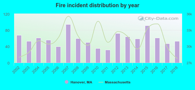 Based on the data from the years 2002 - 2018 the average number of fire incidents per year is 59. The highest number of fires - 94 took place in 2007, and the least - 32 in 2011. The data has a decreasing trend.
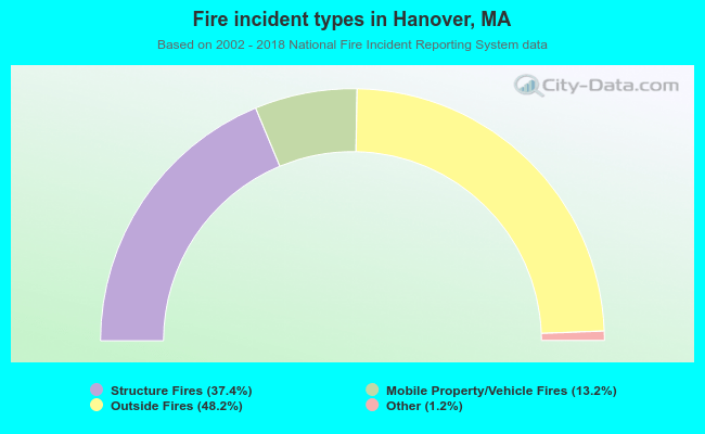 When looking into fire subcategories, the most reports belonged to: Outside Fires (48.2%), and Structure Fires (37.4%).
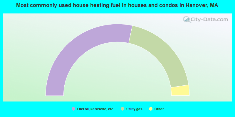
- 56.7%Fuel oil, kerosene, etc.
- 38.6%Utility gas
- 2.5%Electricity
- 1.1%Bottled, tank, or LP gas
- 0.7%Wood
- 0.5%Other fuel
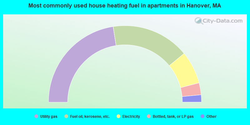
- 45.0%Utility gas
- 33.0%Fuel oil, kerosene, etc.
- 13.8%Electricity
- 5.0%Bottled, tank, or LP gas
- 1.7%No fuel used
- 1.5%Wood
Hanover compared to Massachusetts state average:
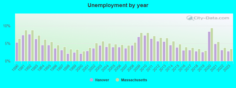
- Unemployed percentage significantly below state average.
- Black race population percentage significantly below state average.
- Hispanic race population percentage significantly below state average.
- Foreign-born population percentage significantly below state average.
- Renting percentage significantly below state average.
- Length of stay since moving in significantly above state average.
- Number of rooms per house significantly below state average.
- House age significantly below state average.
Hanover on our top lists:
- #25 on the list of "Top 101 cities with largest percentage of females in occupations: pipelayers, plumbers, pipefitters, and steamfitters (population 5,000+)"
- #26 on the list of "Top 101 cities with largest percentage of females in occupations: registered nurses (population 5,000+)"
- #27 on the list of "Top 101 cities with largest percentage of females in occupations: social scientists and related workers (population 5,000+)"
- #37 on the list of "Top 101 cities with largest percentage of males in industries: sporting goods, camera, and hobby and toy stores (population 5,000+)"
- #43 on the list of "Top 101 cities with largest percentage of females in industries: book stores and news dealers (population 5,000+)"
- #65 on the list of "Top 101 cities with largest percentage of females in industries: rail transportation (population 5,000+)"
- #70 on the list of "Top 101 cities with largest percentage of females in industries: sewing, needlework, and piece goods stores (population 5,000+)"
- #80 on the list of "Top 101 cities with largest percentage of males in industries: paper and paper products merchant wholesalers (population 5,000+)"
- #82 on the list of "Top 101 cities with largest percentage of males in industries: building material and garden equipment and supplies dealers (population 5,000+)"
- #83 on the list of "Top 101 cities with largest percentage of females in industries: apparel, fabrics, and notions merchant wholesalers (population 5,000+)"
- #85 on the list of "Top 101 cities with largest percentage of females in occupations: top executives (population 5,000+)"
- #50 (02339) on the list of "Top 101 zip codes with the largest percentage of Irish first ancestries (pop 5,000+)"
- #18 on the list of "Top 101 counties with the highest percentage of residents that visited a dentist within the past year"
- #24 on the list of "Top 101 counties with the highest percentage of residents that smoked 100+ cigarettes in their lives"
- #35 on the list of "Top 101 counties with the largest decrease in the number of births per 1000 residents 2000-2006 to 2007-2013 (pop 50,000+)"
- #39 on the list of "Top 101 counties with the lowest percentage of residents that keep firearms around their homes"
- #39 on the list of "Top 101 counties with the lowest number of infant deaths per 1000 residents 2007-2013 (pop. 50,000+)"

|
|
Total of 132 patent applications in 2008-2024.