Harpswell, Maine

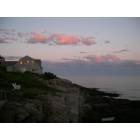
Harpswell: Standing on Orr's looking over to Cook's Restaurant on Bailey Island
Harpswell: Bailey Island
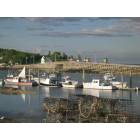
Harpswell: Crib Bridge, Bailey Island
Harpswell: Mackeral cove on a perfect summer afternoon
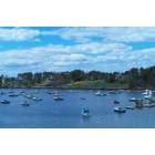
Harpswell: Mackerel Cove, Bailey Island

Harpswell: Quahog Bay Sunrise from Trufant-Summerton Farm
Harpswell: First Place Winner 2009 Portland Press Herald/ Summer Rocks in Maine

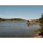
Harpswell: Crossing the bridge onto Orr's in mid fall on a beautiful evening
- add
your


Submit your own pictures of this town and show them to the world
- OSM Map
- Google Map
- MSN Map
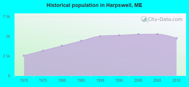
Population change since 2000: -9.5%
 |
| Males: 2,296 | |
| Females: 2,444 |
| Median resident age: | 52.9 years |
| Maine median age: | 43.0 years |
Zip codes: 04066.
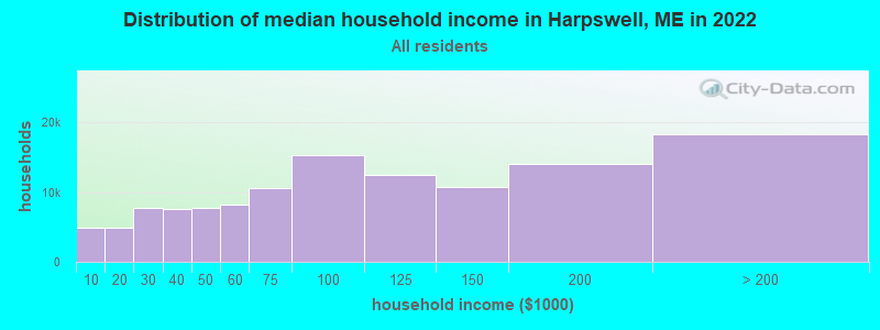
| Harpswell: | $82,374 |
| ME: | $69,543 |
Estimated per capita income in 2022: $69,978 (it was $30,433 in 2000)
Harpswell town income, earnings, and wages data
Estimated median house or condo value in 2022: $534,645 (it was $156,900 in 2000)
| Harpswell: | $534,645 |
| ME: | $290,600 |
Mean prices in 2022: all housing units: $514,200; detached houses: $533,395; townhouses or other attached units: $572,947; in 2-unit structures: $538,406; in 3-to-4-unit structures: $462,507; in 5-or-more-unit structures: $450,834; mobile homes: $93,551
Detailed information about poverty and poor residents in Harpswell, ME


Compare current foreclosures near Harpswell, ME:
| Photo | Address | Area | Beds / Baths | Price | Details |
|---|---|---|---|---|---|

|
#1
Pleasant St
Lisbon Falls, ME 04252
|
561 sq. feet
|
1 baths 2 beds |
show details | |

|
#2
Charles St
Bath, ME 04530
|
- sq. feet
|
3 baths 5 beds |
show details | |

|
#3
Bruce Hill Rd
Cumberland Center, ME 04021
|
2,536 sq. feet
|
2 baths 3 beds |
show details | |

|
#4
Liberty Way
Portland, ME 04103
|
- sq. feet
|
- baths - beds |
show details | |

|
#5
Ocean Ave
Portland, ME 04103
|
- sq. feet
|
- baths - beds |
show details | |

|
#6
Ocean Ave
Portland, ME 04103
|
- sq. feet
|
- baths - beds |
show details | |

|
#7
Bay Shore Rd
Wiscasset, ME 04578
|
- sq. feet
|
- baths - beds |
show details | |

|
#8
Bickford Ave
Brunswick, ME 04011
|
- sq. feet
|
- baths - beds |
show details | |

|
#9
Oak Grove Ave
Bath, ME 04530
|
- sq. feet
|
- baths - beds |
show details | |

|
#10
Heath Ln
Bath, ME 04530
|
- sq. feet
|
- baths - beds |
show details |
| Photo | Address | Area | Beds / Baths | Price | Details |
|---|---|---|---|---|---|

|
#11
Winter St Apt 2
Topsham, ME 04086
|
- sq. feet
|
- baths - beds |
show details | |

|
#12
Durham Rd
Freeport, ME 04032
|
- sq. feet
|
- baths - beds |
show details | |

|
#13
Chase Ct
Freeport, ME 04032
|
- sq. feet
|
- baths - beds |
show details | |

|
#14
Gerald St
Bath, ME 04530
|
- sq. feet
|
- baths - beds |
show details | |

|
#15
Goldeneye Dr
Topsham, ME 04086
|
- sq. feet
|
- baths - beds |
show details | |

|
#16
Adelard Dr
Brunswick, ME 04011
|
- sq. feet
|
- baths - beds |
show details | |

|
#17
Middle Rd
Falmouth, ME 04105
|
- sq. feet
|
- baths - beds |
show details | |

|
#18
Sweeping Oak Ln
Durham, ME 04222
|
- sq. feet
|
- baths - beds |
show details | |

|
#19
Shea St
Brunswick, ME 04011
|
- sq. feet
|
- baths - beds |
show details | |

|
#20
Wing St
Lisbon Falls, ME 04252
|
- sq. feet
|
- baths - beds |
show details |
| Photo | Address | Area | Beds / Baths | Price | Details |
|---|---|---|---|---|---|

|
#21
Morning St # 2
Portland, ME 04101
|
- sq. feet
|
- baths - beds |
show details | |

|
#22
Angel Pl
Bath, ME 04530
|
- sq. feet
|
- baths - beds |
show details | |

|
#23
Ward Cir
Brunswick, ME 04011
|
- sq. feet
|
- baths - beds |
show details | |

|
#24
Providence St
Portland, ME 04103
|
- sq. feet
|
- baths - beds |
show details | |

|
#25
Main Rd
Phippsburg, ME 04562
|
- sq. feet
|
- baths - beds |
show details | |

|
Check over 1 million property listings on Foreclosure.com!
|
browse all offers | |||

- 4,59697.0%White alone
- 621.3%Two or more races
- 390.8%Hispanic
- 280.6%Asian alone
- 100.2%American Indian alone
- 40.08%Black alone
- 10.02%Other race alone

Races in Harpswell detailed stats: ancestries, foreign born residents, place of birth
According to our research of Maine and other state lists, there were 4 registered sex offenders living in Harpswell, Maine as of April 24, 2024.
The ratio of all residents to sex offenders in Harpswell is 1,185 to 1.
The ratio of registered sex offenders to all residents in this city is lower than the state average.
 Recent articles from our blog. Our writers, many of them Ph.D. graduates or candidates, create easy-to-read articles on a wide variety of topics.

Harpswell, ME City Guides:
Ancestries: English (26.5%), Irish (12.9%), United States (8.9%), Scottish (7.8%), French (7.1%), German (6.6%).
Current Local Time: EST time zone
Incorporated in 1758
Land area: 24.2 square miles.
Population density: 196 people per square mile (very low).
218 residents are foreign born (1.4% North America, 1.2% Europe, 1.2% Asia, 0.4% Africa).
| This town: | 4.2% |
| Maine: | 2.9% |
| Harpswell town: | 0.9% ($1,423) |
| Maine: | 1.5% ($1,417) |
Nearest city with pop. 50,000+: Portland, ME  (17.7 miles , pop. 64,249).
Nearest city with pop. 200,000+: Boston, MA (116.3 miles , pop. 589,141).
Nearest city with pop. 1,000,000+: Bronx, NY (285.3 miles , pop. 1,332,650).
Nearest cities:
), ), ), ), )Latitude: 43.79 N, Longitude: 69.96 W
Area code: 207
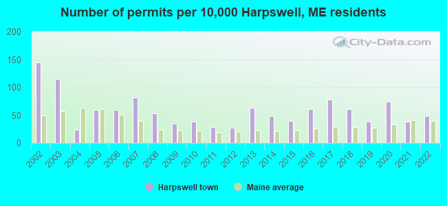
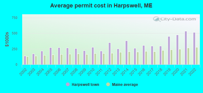
Single-family new house construction building permits:
- 2022: 25 buildings, average cost: $518,300
- 2021: 20 buildings, average cost: $537,200
- 2020: 39 buildings, average cost: $476,700
- 2019: 20 buildings, average cost: $452,100
- 2018: 32 buildings, average cost: $296,700
- 2017: 41 buildings, average cost: $297,500
- 2016: 32 buildings, average cost: $309,400
- 2015: 21 buildings, average cost: $262,700
- 2014: 25 buildings, average cost: $380,700
- 2013: 33 buildings, average cost: $252,400
- 2012: 14 buildings, average cost: $354,400
- 2011: 15 buildings, average cost: $220,900
- 2010: 20 buildings, average cost: $279,200
- 2009: 18 buildings, average cost: $225,000
- 2008: 28 buildings, average cost: $259,000
- 2007: 43 buildings, average cost: $267,700
- 2006: 31 buildings, average cost: $272,500
- 2005: 31 buildings, average cost: $272,600
- 2004: 12 buildings, average cost: $218,500
- 2003: 60 buildings, average cost: $171,900
- 2002: 76 buildings, average cost: $137,700
| Here: | 3.0% |
| Maine: | 3.4% |

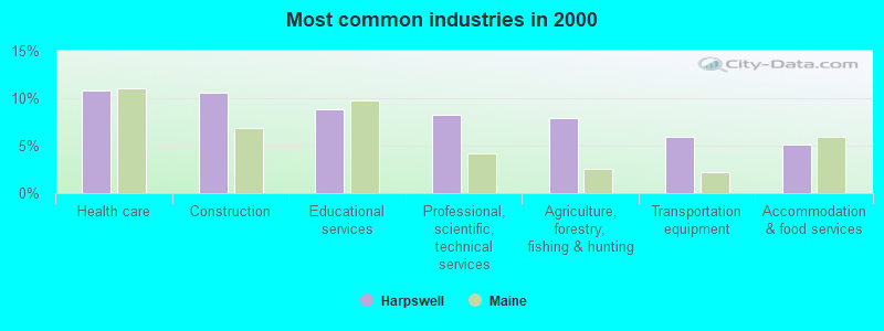
- Health care (10.8%)
- Construction (10.6%)
- Educational services (8.8%)
- Professional, scientific, technical services (8.2%)
- Agriculture, forestry, fishing & hunting (7.9%)
- Transportation equipment (5.9%)
- Accommodation & food services (5.1%)
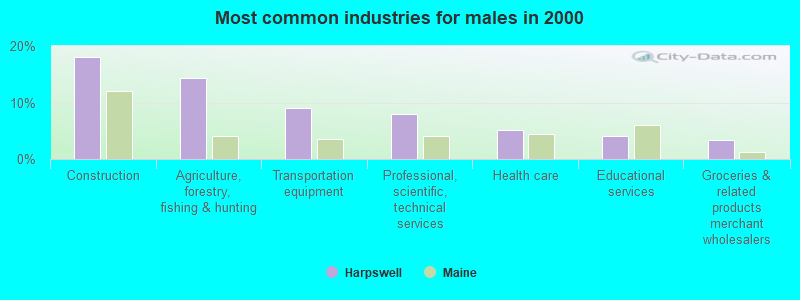
- Construction (18.0%)
- Agriculture, forestry, fishing & hunting (14.3%)
- Transportation equipment (8.9%)
- Professional, scientific, technical services (7.9%)
- Health care (5.2%)
- Educational services (4.0%)
- Groceries & related products merchant wholesalers (3.3%)

- Health care (17.1%)
- Educational services (14.2%)
- Accommodation & food services (8.8%)
- Professional, scientific, technical services (8.6%)
- Social assistance (4.2%)
- Public administration (4.1%)
- Arts, entertainment, recreation (3.7%)
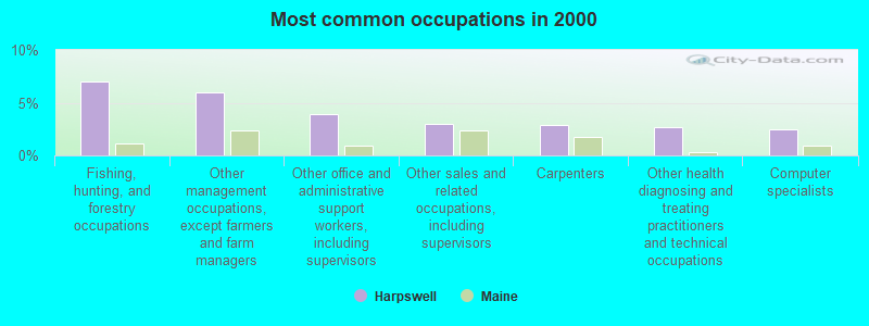
- Fishing, hunting, and forestry occupations (7.0%)
- Other management occupations, except farmers and farm managers (6.0%)
- Other office and administrative support workers, including supervisors (3.9%)
- Other sales and related occupations, including supervisors (3.0%)
- Carpenters (2.9%)
- Other health diagnosing and treating practitioners and technical occupations (2.7%)
- Computer specialists (2.4%)
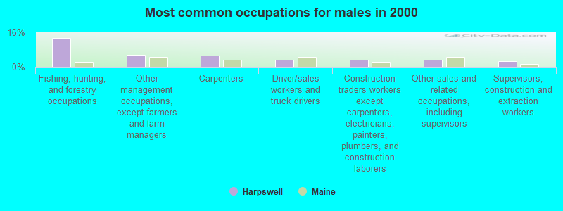
- Fishing, hunting, and forestry occupations (13.3%)
- Other management occupations, except farmers and farm managers (5.7%)
- Carpenters (5.4%)
- Driver/sales workers and truck drivers (3.3%)
- Construction traders workers except carpenters, electricians, painters, plumbers, and construction laborers (3.2%)
- Other sales and related occupations, including supervisors (3.1%)
- Supervisors, construction and extraction workers (2.7%)

- Other office and administrative support workers, including supervisors (8.3%)
- Other management occupations, except farmers and farm managers (6.3%)
- Bookkeeping, accounting, and auditing clerks (4.4%)
- Building and grounds cleaning and maintenance occupations (3.5%)
- Nursing, psychiatric, and home health aides (3.5%)
- Secretaries and administrative assistants (3.3%)
- Preschool, kindergarten, elementary, and middle school teachers (3.2%)
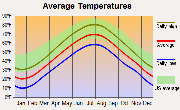
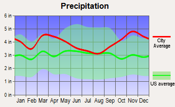
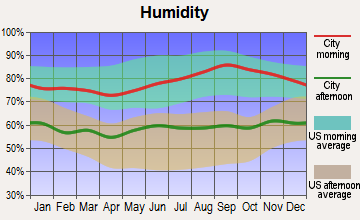
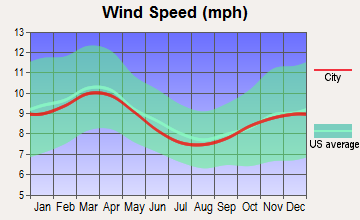
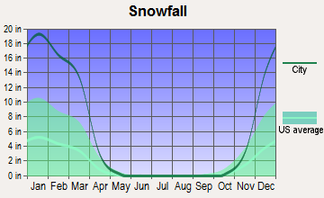
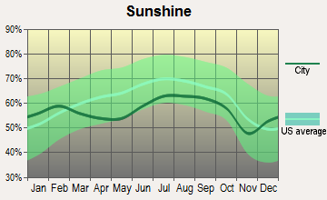
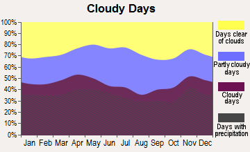
Average climate in Harpswell, Maine
Based on data reported by over 4,000 weather stations
(lower is better)
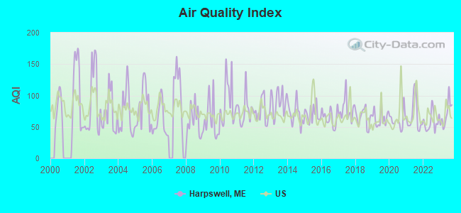
Air Quality Index (AQI) level in 2023 was 70.7. This is about average.
| City: | 70.7 |
| U.S.: | 72.6 |
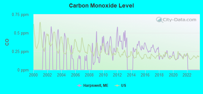
Carbon Monoxide (CO) [ppm] level in 2021 was 0.192. This is better than average. Closest monitor was 17.7 miles away from the city center.
| City: | 0.192 |
| U.S.: | 0.251 |
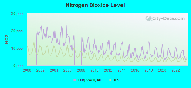
Nitrogen Dioxide (NO2) [ppb] level in 2023 was 5.47. This is about average. Closest monitor was 17.4 miles away from the city center.
| City: | 5.47 |
| U.S.: | 5.11 |
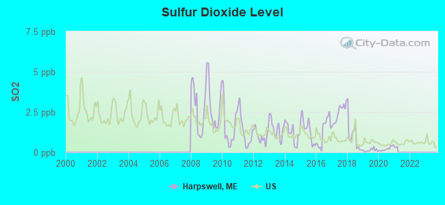
Sulfur Dioxide (SO2) [ppb] level in 2020 was 0.222. This is significantly better than average. Closest monitor was 6.2 miles away from the city center.
| City: | 0.222 |
| U.S.: | 1.515 |
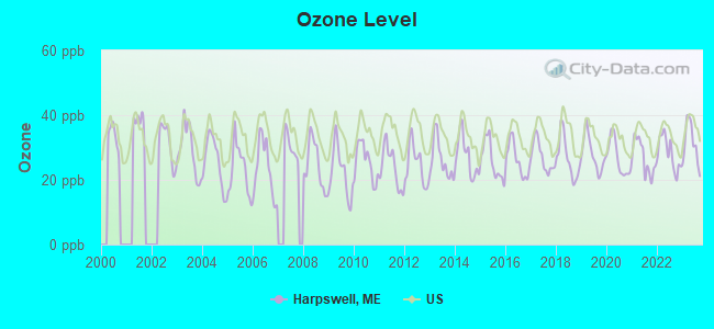
Ozone [ppb] level in 2023 was 31.2. This is about average. Closest monitor was 8.7 miles away from the city center.
| City: | 31.2 |
| U.S.: | 33.3 |
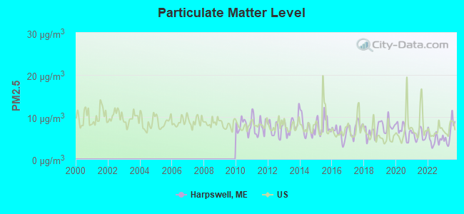
Particulate Matter (PM2.5) [µg/m3] level in 2023 was 6.31. This is better than average. Closest monitor was 16.7 miles away from the city center.
| City: | 6.31 |
| U.S.: | 8.11 |
Earthquake activity:
Harpswell-area historical earthquake activity is significantly above Maine state average. It is 76% smaller than the overall U.S. average.On 10/16/2012 at 23:12:25, a magnitude 4.7 (4.7 ML, Depth: 10.0 mi, Class: Light, Intensity: IV - V) earthquake occurred 37.3 miles away from the city center
On 4/20/2002 at 10:50:47, a magnitude 5.3 (5.3 ML, Depth: 3.0 mi, Class: Moderate, Intensity: VI - VII) earthquake occurred 192.3 miles away from the city center
On 1/19/1982 at 00:14:42, a magnitude 4.7 (4.5 MB, 4.7 MD, 4.5 LG) earthquake occurred 84.6 miles away from the city center
On 4/20/2002 at 10:50:47, a magnitude 5.2 (5.2 MB, 4.2 MS, 5.2 MW, 5.0 MW) earthquake occurred 192.9 miles away from Harpswell center
On 10/7/1983 at 10:18:46, a magnitude 5.3 (5.1 MB, 5.3 LG, 5.1 ML) earthquake occurred 218.9 miles away from Harpswell center
On 2/26/1999 at 03:38:43, a magnitude 3.8 (3.8 LG, Depth: 2.0 mi, Class: Light, Intensity: II - III) earthquake occurred 52.7 miles away from Harpswell center
Magnitude types: regional Lg-wave magnitude (LG), body-wave magnitude (MB), duration magnitude (MD), local magnitude (ML), surface-wave magnitude (MS), moment magnitude (MW)
Natural disasters:
The number of natural disasters in Cumberland County (33) is a lot greater than the US average (15).Major Disasters (Presidential) Declared: 22
Emergencies Declared: 10
Causes of natural disasters: Floods: 19, Storms: 13, Snows: 7, Winter Storms: 6, Heavy Rains: 3, Hurricanes: 3, Winds: 3, Blizzard: 1, Ice Storm: 1, Mudslide: 1, Snowfall: 1, Snowstorm: 1, Tornado: 1, Other: 2 (Note: some incidents may be assigned to more than one category).
Hospitals and medical centers near Harpswell:
- HORIZONS LIVING AND REHAB CENTER (Nursing Home, about 8 miles away; BRUNSWICK, ME)
- DIONNE COMMONS (Nursing Home, about 8 miles away; BRUNSWICK, ME)
- COMMUNITY HEALTH AND NURSING SERVICES (Home Health Center, about 8 miles away; BRUNSWICK, ME)
- MID COAST SENIOR HEALTH CENTER (Nursing Home, about 8 miles away; BRUNSWICK, ME)
- FREEPORT NURSING AND REHAB CENTER (Nursing Home, about 9 miles away; FREEPORT, ME)
- BRUNSWICK MANOR (Nursing Home, about 9 miles away; BRUNSWICK, ME)
- COASTAL DIALYSIS CENTER (Dialysis Facility, about 11 miles away; BATH, ME)
Airports located in Harpswell:
- Farr Field Airport (ME33) (Runways: 1)
Colleges/universities with over 2000 students nearest to Harpswell:
- Southern Maine Community College (about 17 miles; South Portland, ME; Full-time enrollment: 4,666)
- University of Southern Maine (about 19 miles; Portland, ME; FT enrollment: 6,647)
- Saint Joseph's College of Maine (about 27 miles; Standish, ME; FT enrollment: 2,010)
- University of New England (about 32 miles; Biddeford, ME; FT enrollment: 4,539)
- University of Maine at Augusta (about 40 miles; Augusta, ME; FT enrollment: 3,204)
- University of Maine at Farmington (about 62 miles; Farmington, ME; FT enrollment: 2,036)
- University of New Hampshire-Main Campus (about 67 miles; Durham, NH; FT enrollment: 15,243)
Public high school in Harpswell:
Public elementary/middle school in Harpswell:
- HARPSWELL COMMUNITY SCHOOL (Location: 308 HARPSWELL ISLANDS ROAD, Grades: KG-5)
Points of interest:
Notable locations in Harpswell: Oak Ledge Camp (A), Watsons Marina (B), Orrs-Bailey Yacht Club (C), Orrs Island Campground (D), Mackerel Cove Marina (E), Holbrooks Marina (F), High Head Yacht Club (G), Orrs Island Fire Department (H), Cundys Harbor Volunteer Fire Department (I), Harpswell Neck Volunteer Fire Department (J), Harpswell Historical Society Building (K), Harpswell Town Offices (L). Display/hide their locations on the map
Churches in Harpswell include: Queen of the Mission Chapel (A), Harpswell Meetinghouse (B), Union Church (C), East Harpswell Free Will Baptist Church (D). Display/hide their locations on the map
Cemetery: Cranberryhorn Cemetery (1). Display/hide its location on the map
Reservoir: Wilson Pond (A). Display/hide its location on the map
Creek: Strawberry Creek (A). Display/hide its location on the map
Park in Harpswell: Lobstermans Statue (1). Display/hide its location on the map
Drinking water stations with addresses in Harpswell and their reported violations in the past:
ESTES LOBSTER HOUSE (Population served: 450, Groundwater):Past health violations:BLOCK & TACKLE (Population served: 240, Groundwater):Past monitoring violations:
- MCL, Monthly (TCR) - In JUN-2007, Contaminant: Coliform. Follow-up actions: St Public Notif requested (JUN-08-2007), St Violation/Reminder Notice (JUN-08-2007), St Compliance achieved (MAY-13-2009), St Intentional no-action (SEP-15-2011)
- MCL, Monthly (TCR) - In MAY-2007, Contaminant: Coliform. Follow-up actions: St Public Notif requested (MAY-21-2007), St Violation/Reminder Notice (MAY-21-2007), St Compliance achieved (MAY-13-2009), St Intentional no-action (SEP-15-2011)
- MCL, Monthly (TCR) - In APR-2007, Contaminant: Coliform. Follow-up actions: St Public Notif requested (MAY-10-2007), St Violation/Reminder Notice (MAY-10-2007), St Public Notif received (MAY-18-2007), St Compliance achieved (MAY-13-2009)
- 2 routine major monitoring violations
Past monitoring violations:DOLPHIN MARINA & RESTAURANT (Population served: 200, Groundwater):
- One regular monitoring violation
Past health violations:MORSES CRIBSTONE GRILL (Population served: 195, Groundwater):Past monitoring violations:
- MCL, Monthly (TCR) - Between OCT-2008 and DEC-2008, Contaminant: Coliform. Follow-up actions: St Formal NOV issued (NOV-10-2008), St Public Notif requested (NOV-10-2008), St Public Notif received (MAY-04-2009), St Compliance achieved (MAY-12-2009)
- MCL, Acute (TCR) - In OCT-2005, Contaminant: Coliform. Follow-up actions: St Tech Assistance Visit (NOV-01-2005), St Violation/Reminder Notice (NOV-01-2005), St Public Notif requested (NOV-01-2005), St Compliance Meeting conducted (NOV-01-2005), St Boil Water Order (NOV-01-2005), St Public Notif received (APR-24-2006), St Compliance achieved (JAN-29-2007)
- One routine major monitoring violation
Past health violations:AUBURN COLONY DINING HALL (Population served: 125, Groundwater):Past monitoring violations:
- MCL, Acute (TCR) - In JUN-2012, Contaminant: Coliform. Follow-up actions: St Tech Assistance Visit (JUL-02-2012), St Compliance Meeting conducted (JUL-02-2012), St Boil Water Order (JUL-02-2012), St Public Notif requested (JUL-02-2012), St Compliance achieved (JUL-02-2012), St Formal NOV issued (JUL-02-2012), St Public Notif received (JUL-02-2013), St Site Visit (enforcement) (JUL-03-2013)
- 8 routine major monitoring violations
- One minor monitoring violation
- 2 regular monitoring violations
Past monitoring violations:THE HARPSWELL INN (Population served: 120, Groundwater):
- Monitoring, Repeat Major (TCR) - In AUG-2006, Contaminant: Coliform (TCR). Follow-up actions: St Public Notif requested (SEP-07-2006), St Violation/Reminder Notice (SEP-07-2006), St Public Notif received (NOV-17-2010), St Compliance achieved (JUL-20-2011)
- 7 routine major monitoring violations
- One regular monitoring violation
Past monitoring violations:MILLSTONE APARTMENTS (Population served: 97, Groundwater):
- 4 routine major monitoring violations
Past health violations:Past monitoring violations:
- MCL, Monthly (TCR) - In OCT-2005, Contaminant: Coliform. Follow-up actions: St Public Notif requested (OCT-19-2005), St Violation/Reminder Notice (OCT-19-2005), St Public Notif received (2 times from NOV-10-2005 to MAY-05-2006), St Compliance achieved (APR-22-2011)
- MCL, Monthly (TCR) - In SEP-2005, Contaminant: Coliform. Follow-up actions: St Public Notif requested (SEP-30-2005), St Violation/Reminder Notice (SEP-30-2005), St Public Notif received (2 times from NOV-16-2005 to MAY-05-2006), St Compliance achieved (APR-22-2011)
- MCL, Monthly (TCR) - In FEB-2005, Contaminant: Coliform. Follow-up actions: St Public Notif requested (FEB-18-2005), St Violation/Reminder Notice (FEB-18-2005), St Public Notif received (2 times from APR-06-2005 to MAY-05-2006), St Compliance achieved (APR-22-2011)
- Follow-up Or Routine LCR Tap M/R - In JUL-11-2003, Contaminant: Lead and Copper Rule. Follow-up actions: St Public Notif requested (JUN-01-2005), St Violation/Reminder Notice (JUN-01-2005), St Public Notif received (JUN-13-2005), St Compliance achieved (SEP-06-2005)
- 5 routine major monitoring violations
- 2 regular monitoring violations
Drinking water stations with addresses in Harpswell that have no violations reported:
- MERRIMANS COVE ASSOCIATION INC (Population served: 55, Primary Water Source Type: Groundwater under infl of surface water)
| This town: | 2.1 people |
| Maine: | 2.3 people |
| This town: | 65.4% |
| Whole state: | 62.9% |
| This town: | 9.1% |
| Whole state: | 9.4% |
Likely homosexual households (counted as self-reported same-sex unmarried-partner households)
- Lesbian couples: 0.9% of all households
- Gay men: 0.6% of all households
| This town: | 5.6% |
| Whole state: | 10.9% |
| This town: | 2.4% |
| Whole state: | 4.1% |
4 people in homes for the mentally retarded in 2000
For population 15 years and over in Harpswell:
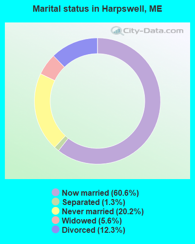
- Never married: 20.2%
- Now married: 60.6%
- Separated: 1.3%
- Widowed: 5.6%
- Divorced: 12.3%
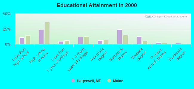
For population 25 years and over in Harpswell:
- High school or higher: 88.9%
- Bachelor's degree or higher: 42.2%
- Graduate or professional degree: 17.9%
- Unemployed: 2.2%
- Mean travel time to work (commute): 31.5 minutes
| Here: | 12.2 |
| Maine average: | 11.2 |

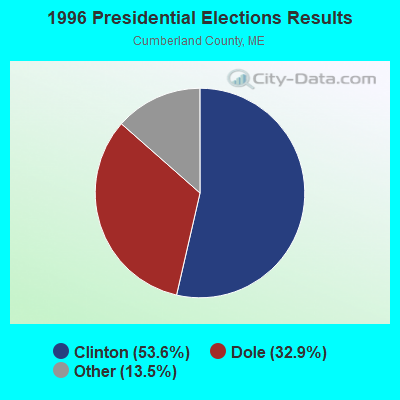
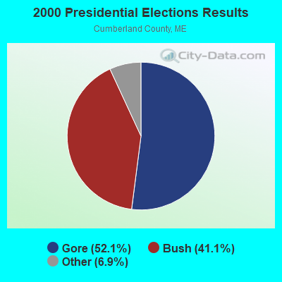


Graphs represent county-level data. Detailed 2008 Election Results
Religion statistics for Harpswell, ME (based on Cumberland County data)
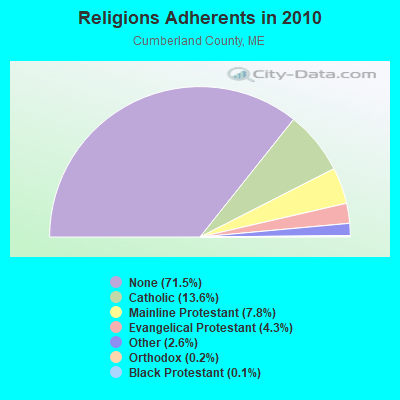
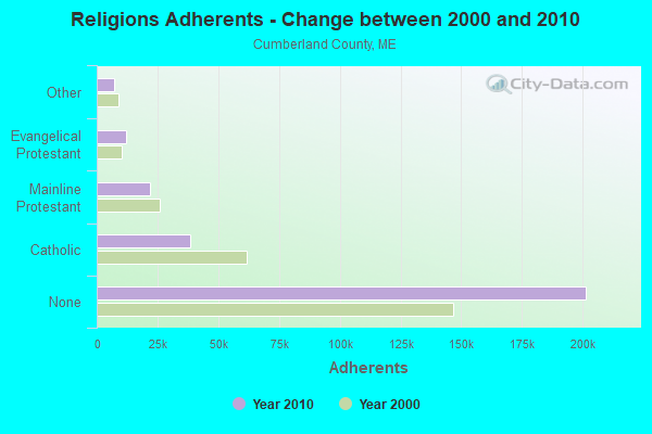
| Religion | Adherents | Congregations |
|---|---|---|
| Catholic | 38,243 | 19 |
| Mainline Protestant | 22,030 | 96 |
| Evangelical Protestant | 12,007 | 85 |
| Other | 7,187 | 44 |
| Orthodox | 500 | 1 |
| Black Protestant | 285 | 2 |
| None | 201,422 | - |
Food Environment Statistics:
| This county: | 2.62 / 10,000 pop. |
| State: | 2.80 / 10,000 pop. |
| This county: | 0.11 / 10,000 pop. |
| Maine: | 0.14 / 10,000 pop. |
| Here: | 2.44 / 10,000 pop. |
| Maine: | 2.20 / 10,000 pop. |
| Here: | 3.82 / 10,000 pop. |
| Maine: | 5.75 / 10,000 pop. |
| Cumberland County: | 12.01 / 10,000 pop. |
| State: | 11.02 / 10,000 pop. |
| Cumberland County: | 7.1% |
| Maine: | 8.2% |
| This county: | 19.5% |
| Maine: | 25.0% |
Strongest AM radio stations in Harpswell:
- WGAN (560 AM; 5 kW; PORTLAND, ME; Owner: SAGA COMMUNICATIONS OF NEW ENGLAND, LLC)
- WJTO (730 AM; 1 kW; BATH, ME; Owner: BLUE JEY BROADCASTING COMPANY)
- WMTW (870 AM; 10 kW; GORHAM, ME; Owner: RADIO PARTNERS OF MAINE, L.P.)
- WJJB (900 AM; 1 kW; BRUNSWICK, ME; Owner: ATLANTIC COAST RADIO, LLC)
- WZAN (970 AM; 5 kW; PORTLAND, ME; Owner: SAGA COMMUNICATIONS OF NEW ENGLAND, LLC)
- WLOB (1310 AM; 5 kW; PORTLAND, ME; Owner: ATLANTIC COAST RADIO, LLC)
- WJAE (1440 AM; 5 kW; WESTBROOK, ME; Owner: ALTANTIC COAST RADIO, LLC)
- WLAM (1470 AM; 5 kW; LEWISTON, ME; Owner: RADIO PARTNERS OF MAINE, L.P.)
- WRKO (680 AM; 50 kW; BOSTON, MA; Owner: ENTERCOM BOSTON LICENSE, LLC)
- WEEI (850 AM; 50 kW; BOSTON, MA; Owner: ENTERCOM BOSTON LICENSE, LLC)
- WTME (780 AM; 10 kW; RUMFORD, ME; Owner: MOUNTAIN VALLEY BROADCASTING, INC.)
- WBZ (1030 AM; 50 kW; BOSTON, MA; Owner: INFINITY BROADCASTING OPERATIONS, INC.)
- WFAU (1280 AM; 5 kW; GARDINER, ME; Owner: CAPSTAR TX LIMITED PARTNERSHIP)
Strongest FM radio stations in Harpswell:
- WYFP (91.9 FM; HARPSWELL, ME; Owner: BIBLE BROADCASTING NETWORK, INC.)
- WJJB-FM (95.5 FM; TOPSHAM, ME; Owner: ATLANTIC COAST RADIO, LLC)
- WCLZ (98.9 FM; BRUNSWICK, ME; Owner: CITADEL BROADCASTING COMPANY)
- WYNZ (100.9 FM; WESTBROOK, ME; Owner: SAGA COMMUNICATIONS OF NEW ENGLAND, LLC)
- WJBQ (97.9 FM; PORTLAND, ME; Owner: CITADEL BROADCASTING COMPANY)
- WTHT (107.5 FM; LEWISTON, ME; Owner: RADIO PARTNERS OF MAINE, L.P.)
- WBLM (102.9 FM; PORTLAND, ME; Owner: CITADEL BROADCASTING COMPANY)
- WMEA (90.1 FM; PORTLAND, ME; Owner: MAINE PUBLIC BROADCASTING CORPORATION)
- WPOR (101.9 FM; PORTLAND, ME; Owner: SAGA COMMUNICATIONS OF NEW ENGLAND, LLC)
- WPKQ (103.7 FM; NORTH CONWAY, NH; Owner: CITADEL BROADCASTING COMPANY)
- WMTW-FM (106.7 FM; NORTH WINDHAM, ME; Owner: RADIO PARTNERS OF MAINE, L.P.)
- WHOM (94.9 FM; MT. WASHINGTON, NH; Owner: CITADEL BROADCASTING COMPANY)
- WMEK-FM (99.9 FM; AUBURN, ME; Owner: RADIO PARTNERS OF MAINE, L.P.)
- WMGX (93.1 FM; PORTLAND, ME; Owner: SAGA COMMUNICATIONS OF NEW ENGLAND, LLC)
- WMSJ (89.3 FM; FREEPORT, ME; Owner: DOWNEAST CHRISTIAN COMMUNICATIONS)
- WBCI (105.9 FM; BATH, ME; Owner: BLOUNT COMMUNICATIONS, INC.)
- WCYI (93.9 FM; LEWISTON, ME; Owner: CITADEL BROADCASTING COMPANY)
- WCYY (94.3 FM; BIDDEFORD, ME; Owner: CITADEL BROADCASTING COMPANY)
- WCME (96.7 FM; BOOTHBAY HARBOR, ME; Owner: CAPSTAR TX LIMITED PARTNERSHIP)
- WRED (95.9 FM; SACO, ME; Owner: ATLANTIC COAST RADIO, LLC)
TV broadcast stations around Harpswell:
- WGME-TV (Channel 13; PORTLAND, ME; Owner: WGME LICENSEE, LLC)
- WPXT (Channel 51; PORTLAND, ME; Owner: HMW, INC.)
- WPME (Channel 35; LEWISTON, ME; Owner: KB PRIME MEDIA LLC)
- WMTW-TV (Channel 8; POLAND SPRING, ME; Owner: WMTW BROADCAST GROUP, LLC)
- WCSH (Channel 6; PORTLAND, ME; Owner: PACIFIC AND SOUTHERN COMPANY, INC.)
- W32CA (Channel 32; PORTLAND, ME; Owner: NATIONAL MINORITY T.V., INC.)
- WPFO (Channel 23; WATERVILLE, ME; Owner: CMCG PORTLAND LICENSE LLC)
- WMEA-TV (Channel 26; BIDDEFORD, ME; Owner: MAINE PUBLIC BROADCASTING CORP.)
- WCBB (Channel 10; AUGUSTA, ME; Owner: MAINE PUBLIC BROADCASTING CORP.)
- W58CM (Channel 58; BANGOR, ME; Owner: MS COMMUNICATIONS, LLC)
- W57AP (Channel 57; FALMOUTH, ME; Owner: SHERWOOD H. CRAIG)
- National Bridge Inventory (NBI) Statistics
- 4Number of bridges
- 92ft / 27.7mTotal length
- 12,449Total average daily traffic
- 621Total average daily truck traffic
- 17,469Total future (year 2036) average daily traffic
FCC Registered Antenna Towers:
13 (See the full list of FCC Registered Antenna Towers in Harpswell)FCC Registered Broadcast Land Mobile Towers:
3- 11 Mitchell Field Drive (Lat: 43.770778 Lon: -70.010028), Type: Ltower, Structure height: 60.1 m, Overall height: 60.7 m, Call Sign: KNES301,
Assigned Frequencies: 154.190 MHz, Grant Date: 10/07/2014, Expiration Date: 12/05/2024, Registrant: Radio Communications Management, 158 Rand Rd, Portland, ME 04103, Phone: (207) 797-7503, Email:
- HARPSWELL, Off Of Community Dr. At Harpswell Recycling Center (Lat: 43.814167 Lon: -69.940972), Type: Gtower, Structure height: 97.5 m, Overall height: 98.8 m, Call Sign: WQKL561,
Assigned Frequencies: 151.107 MHz, 154.875 MHz, 155.625 MHz, Grant Date: 04/18/2019, Expiration Date: 07/06/2029, Certifier: William Holmes, Registrant: Radio Communications Management, 158 Rand Rd, Portland, ME 04103, Phone: (207) 797-7503, Fax: (717) 221-8860, Email:
- Lat: 43.786389 Lon: -69.959806, Call Sign: WRUY834,
Assigned Frequencies: 159.000 MHz, 159.000 MHz, Grant Date: 10/19/2022, Expiration Date: 10/19/2032, Certifier: Terri Lynn Gaudet, Registrant: Dirigo Wireless, Inc., 41 Lewiston Rd., Gray, ME 04039, Phone: (207) 513-1110, Email:
FCC Registered Microwave Towers:
4- HARPSWELL, Off Of Community Dr. At Harpswell Recycling Center (Lat: 43.814167 Lon: -69.940972), Type: Gtower, Structure height: 97.5 m, Overall height: 98.8 m, Call Sign: WQLC428, Licensee ID: L00046814,
Assigned Frequencies: 6345.49 MHz, 6345.49 MHz, 6345.49 MHz, 6345.49 MHz, 6345.49 MHz, 6345.49 MHz, 6345.49 MHz, 6345.49 MHz, 6345.49 MHz, Grant Date: 09/11/2019, Expiration Date: 12/02/2029, Certifier: William Holmes, Registrant: Cumberland County, Maine, 22 High Street, Unit 1, Windham, ME 04062, Phone: (207) 892-6785, Fax: (207) 892-8617, Email:
- COASTAL STUD, 240 Bayview Rd (Lat: 43.788667 Lon: -69.957694), Type: Building, Structure height: 11.6 m, Overall height: 13.6 m, Call Sign: WRPJ463,
Assigned Frequencies: 941.562 MHz, Grant Date: 02/11/2022, Expiration Date: 02/11/2032, Certifier: Steven Blanc, Registrant: Radio Communications Management, Inc, 158 Rand Rd, Portland, ME 04102, Phone: (207) 797-7503, Email:
- CRWN, Off Of Community Dr. At Harpswell Recycling Center (Lat: 43.814167 Lon: -69.940972), Type: Gtower, Structure height: 97.5 m, Overall height: 98.8 m, Call Sign: WRZM713,
Assigned Frequencies: 11395.0 MHz, 11435.0 MHz, 11395.0 MHz, 11435.0 MHz, 11395.0 MHz, 11435.0 MHz, 11395.0 MHz, 11435.0 MHz, 11395.0 MHz, 11435.0 MHz... (+8 more), Grant Date: 11/20/2023, Expiration Date: 11/20/2033, Certifier: Catherine Doughty, Registrant: Radio Communications Management Inc., 158 Rand Road, Rcm, Portland, ME 04102, Phone: (207) 797-7503, Email:
- BLSKY, 11 Mitchell Field Drive (Lat: 43.770778 Lon: -70.010028), Type: Ltower, Structure height: 60.1 m, Overall height: 60.7 m, Call Sign: WRZM714,
Assigned Frequencies: 10855.0 MHz, 10905.0 MHz, 10855.0 MHz, 10905.0 MHz, 10855.0 MHz, 10905.0 MHz, 10855.0 MHz, 10905.0 MHz, 10855.0 MHz, 10905.0 MHz... (+8 more), Grant Date: 11/20/2023, Expiration Date: 11/20/2033, Certifier: Catherine Doughty, Registrant: Radio Communications Management Inc., 158 Rand Road, Rcm, Portland, ME 04102, Phone: (207) 797-7503, Email:
FCC Registered Maritime Coast & Aviation Ground Towers:
2- Rt 1 Mountain Rd Great Island (Lat: 43.797583 Lon: -69.939778), Type: Tower, Call Sign: KZV802, Licensee ID: L00022877,
Assigned Frequencies: 156.425 MHz, 156.800 MHz, 156.450 MHz, Grant Date: 06/25/1998, Expiration Date: 08/19/2003, Cancellation Date: 10/19/2003, Registrant: Long Reach Charter Inc, Rt 1 Box 348, Orrs Island, ME 04066
- Dyers Cove Fr 10 (Lat: 43.833417 Lon: -70.384500), Type: Building, Overall height: 3 m, Call Sign: WHG616, Licensee ID: L00001830,
Assigned Frequencies: 156.450 MHz, 156.800 MHz, 156.900 MHz, 156.950 MHz, Grant Date: 10/10/1995, Expiration Date: 10/10/2000, Cancellation Date: 05/06/2001, Registrant: University Of Maine, Rr 2 Box 2251c, Brunswick, ME 04011
FCC Registered Amateur Radio Licenses:
24 (See the full list of FCC Registered Amateur Radio Licenses in Harpswell)FAA Registered Aircraft:
5- Aircraft: PIPER PA-28R-201T (Category: Land, Seats: 4, Weight: Up to 12,499 Pounds, Speed: 108 mph), Engine: CONT MOTOR TSIO-360 SER (225 HP) (Reciprocating)
N-Number: 143PB, N143PB, N-143PB, Serial Number: 28R-7703243, Year manufactured: 1977, Airworthiness Date: 07/14/1977, Certificate Issue Date: 04/24/2017
Registrant (LLC): Scotts Aviation LLC, 1829 Harpswell Neck Rd, Harpswell, ME 04079 - Aircraft: DOUGLAS K THOMPSON JUSTAIRCRAFT SUPERST (Category: Land, Seats: 2, Weight: Up to 12,499 Pounds), Engine: ROTAX 912ULS SERIES (100 HP) (4 Cycle)
N-Number: 184DT, N184DT, N-184DT, Serial Number: JA284-01-13, Year manufactured: 2014, Airworthiness Date: 03/22/2014, Certificate Issue Date: 07/16/2020
Registrant (Individual): William O Saxton, 498 Basin Point Rd, Harpswell, ME 04079 - Aircraft: BUCKEYE AVIATION 98 DREAM MACHINE (Category: Land, Seats: 2, Weight: Up to 12,499 Pounds), Engine: ROTAX 582SER (65 HP) (2 Cycle)
N-Number: 713BF, N713BF, N-713BF, Serial Number: 4272, Year manufactured: 1998, Airworthiness Date: 01/18/2008, Certificate Issue Date: 11/08/2007
Registrant (Individual): Prescott E Mccurdy, 34 Allen Point Rd, Harpswell, ME 04079 - Aircraft: BEECH F33A (Category: Land, Seats: 5, Weight: Up to 12,499 Pounds, Speed: 138 mph), Engine: CONT MOTOR IO 520 SERIES (285 HP) (Reciprocating)
N-Number: 89SG, N89SG, N-89SG, Serial Number: CE-1357, Year manufactured: 1989, Airworthiness Date: 06/09/1989, Certificate Issue Date: 03/27/2013
Registrant (Individual): Christopher L Hatch, Po Box 62, Harpswell, ME 04079 - Aircraft: DORFMAN WILLIAM A BEDE 4 (Category: Land, Seats: 4, Weight: Up to 12,499 Pounds), Engine: LYCOMING O&VO-360 SER (180 HP) (Reciprocating)
N-Number: 58266, N58266, N-58266, Serial Number: 275, Airworthiness Date: 10/28/1985, Certificate Issue Date: 01/03/2000
Registrant (Individual): Frederick O Dammann, 12 Karls Spur, Harpswell, ME 04079
Deregistered: Cancel Date: 01/25/2018
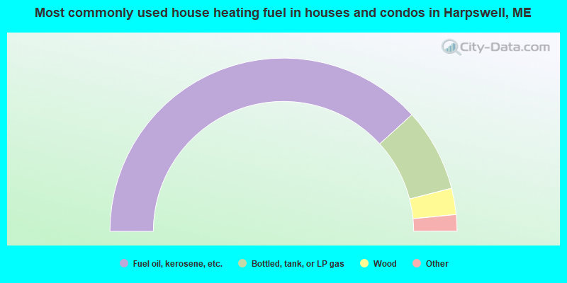
- 76.5%Fuel oil, kerosene, etc.
- 15.5%Bottled, tank, or LP gas
- 4.9%Wood
- 1.6%Electricity
- 1.0%Utility gas
- 0.5%Solar energy
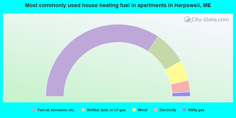
- 68.8%Fuel oil, kerosene, etc.
- 14.9%Bottled, tank, or LP gas
- 9.1%Wood
- 5.2%Electricity
- 2.0%Utility gas
Harpswell compared to Maine state average:
- Median house value above state average.
- Unemployed percentage significantly below state average.
- Black race population percentage significantly below state average.
- Hispanic race population percentage below state average.
- Median age significantly above state average.
- Length of stay since moving in significantly above state average.
- Number of rooms per house significantly below state average.
- House age significantly below state average.
- Percentage of population with a bachelor's degree or higher above state average.

|
|
Total of 26 patent applications in 2008-2024.