Havasupai, Arizona
Submit your own pictures of this place and show them to the world
- OSM Map
- General Map
- Google Map
- MSN Map

| Males: 263 | |
| Females: 286 |
| Median resident age: | 24.9 years |
| Arizona median age: | 34.2 years |
Zip code: 86435
| Havasupai: | $32,925 |
| AZ: | $74,568 |
Estimated per capita income in 2022: $14,410 (it was $7,422 in 2000)
Havasupai CCD income, earnings, and wages data
Estimated median house or condo value in 2022: $75,506 (it was $20,500 in 2000)
| Havasupai: | $75,506 |
| AZ: | $402,800 |
Mean prices in 2022: all housing units: $534,481; detached houses: $608,062; townhouses or other attached units: $531,298; in 2-unit structures: $871,912; in 3-to-4-unit structures: $994,763; in 5-or-more-unit structures: $343,515; mobile homes: $170,991; occupied boats, rvs, vans, etc.: $11,864
Detailed information about poverty and poor residents in Havasupai, AZ


- 44989.3%American Indian alone
- 458.9%White alone
- 91.8%Hispanic

 Recent articles from our blog. Our writers, many of them Ph.D. graduates or candidates, create easy-to-read articles on a wide variety of topics.

Current Local Time: MST (no DST) time zone
Land area: 276.1 square miles.
Population density: 2.0 people per square mile (very low).

| Havasupai CCD: | 1.0% ($199) |
| Arizona: | 0.9% ($962) |
Nearest city with pop. 50,000+: Flagstaff, AZ  (84.7 miles , pop. 52,894).
Nearest city with pop. 200,000+: Las Vegas, NV (146.3 miles , pop. 478,434).
Nearest city with pop. 1,000,000+: Phoenix, AZ (182.7 miles , pop. 1,321,045).
Nearest cities:
), ), Latitude: 36.13 N, Longitude: 112.60 W
Area code commonly used in this area: 928


| Here: | 4.3% |
| Arizona: | 3.8% |

- Public administration (23.5%)
- Accommodation & food services (17.3%)
- U. S. Postal service (13.6%)
- Educational services (8.6%)
- Agriculture, forestry, fishing & hunting (4.9%)
- Food & beverage stores (4.9%)
- Professional, scientific, technical services (4.9%)

- Public administration (26.6%)
- Accommodation & food services (14.1%)
- U. S. Postal service (12.5%)
- Agriculture, forestry, fishing & hunting (6.2%)
- Food & beverage stores (6.2%)
- Professional, scientific, technical services (6.2%)
- Administrative & support & waste management services (6.2%)

- Accommodation & food services (29.4%)
- U. S. Postal service (17.6%)
- Educational services (17.6%)
- Computer & electronic products (11.8%)
- Public administration (11.8%)
- Finance & insurance (11.8%)

- Cooks and food preparation workers (17.3%)
- Material recording, scheduling, dispatching, and distributing workers (13.6%)
- Laborers and material movers, hand (9.9%)
- Preschool, kindergarten, elementary, and middle school teachers (8.6%)
- Construction traders workers except carpenters, electricians, painters, plumbers, and construction laborers (7.4%)
- Law enforcement workers, including supervisors (4.9%)
- Other protective service workers, including supervisors (4.9%)

- Cooks and food preparation workers (14.1%)
- Material recording, scheduling, dispatching, and distributing workers (12.5%)
- Laborers and material movers, hand (12.5%)
- Construction traders workers except carpenters, electricians, painters, plumbers, and construction laborers (9.4%)
- Preschool, kindergarten, elementary, and middle school teachers (6.2%)
- Religious workers (6.2%)
- Law enforcement workers, including supervisors (6.2%)

- Cooks and food preparation workers (29.4%)
- Preschool, kindergarten, elementary, and middle school teachers (17.6%)
- Material recording, scheduling, dispatching, and distributing workers (17.6%)
- Information and record clerks, except customer service representatives (11.8%)
- Child care workers (11.8%)
- Bookkeeping, accounting, and auditing clerks (11.8%)
Average climate in Havasupai, Arizona
Based on data reported by over 4,000 weather stations


(lower is better)

Air Quality Index (AQI) level in 2023 was 65.2. This is about average.
| City: | 65.2 |
| U.S.: | 72.6 |

Ozone [ppb] level in 2023 was 48.6. This is significantly worse than average. Closest monitor was 24.0 miles away from the city center.
| City: | 48.6 |
| U.S.: | 33.3 |
Earthquake activity:
Havasupai-area historical earthquake activity is significantly above Arizona state average. It is 3450% greater than the overall U.S. average.On 6/28/1992 at 11:57:34, a magnitude 7.6 (6.2 MB, 7.6 MS, 7.3 MW, Depth: 0.7 mi, Class: Major, Intensity: VIII - XII) earthquake occurred 259.9 miles away from Havasupai center, causing 3 deaths (1 shaking deaths, 2 other deaths) and 400 injuries, causing $100,000,000 total damage and $40,000,000 insured losses
On 10/16/1999 at 09:46:44, a magnitude 7.4 (6.3 MB, 7.4 MS, 7.2 MW, 7.3 ML) earthquake occurred 243.6 miles away from Havasupai center
On 7/21/1952 at 11:52:14, a magnitude 7.7 (7.7 UK) earthquake occurred 368.3 miles away from Havasupai center, causing $50,000,000 total damage
On 5/19/1940 at 04:36:40, a magnitude 7.2 (7.2 UK) earthquake occurred 267.5 miles away from Havasupai center, causing $33,000,000 total damage
On 12/31/1934 at 18:45:56, a magnitude 7.1 (7.1 UK) earthquake occurred 299.0 miles away from the city center
On 10/3/1915 at 06:52:48, a magnitude 7.6 (7.6 UK) earthquake occurred 402.1 miles away from the city center
Magnitude types: body-wave magnitude (MB), local magnitude (ML), surface-wave magnitude (MS), moment magnitude (MW)
Natural disasters:
The number of natural disasters in Coconino County (17) is near the US average (15).Major Disasters (Presidential) Declared: 8
Emergencies Declared: 3
Causes of natural disasters: Fires: 6, Floods: 6, Storms: 5, Winter Storms: 2, Drought: 1, Flash Flood: 1, Heavy Rain: 1, Hurricane: 1, Tornado: 1, Other: 1 (Note: some incidents may be assigned to more than one category).
Colleges/universities with over 2000 students nearest to Havasupai:
- Northern Arizona University (about 85 miles; Flagstaff, AZ; Full-time enrollment: 22,494)
- Coconino Community College (about 86 miles; Flagstaff, AZ; FT enrollment: 2,090)
- Dixie State University (about 86 miles; Saint George, UT; FT enrollment: 6,485)
- Mohave Community College (about 101 miles; Kingman, AZ; FT enrollment: 3,309)
- Northcentral University (about 108 miles; Prescott Valley, AZ; FT enrollment: 5,927)
- Southern Utah University (about 110 miles; Cedar City, UT; FT enrollment: 6,522)
- Yavapai College (about 111 miles; Prescott, AZ; FT enrollment: 4,258)
Points of interest:
Notable locations in Havasupai: Hualapai Hilltop (A), Topocoba Hilltop (B). Display/hide their locations on the map
Reservoirs: Hidden Log Tank (A), Little Jim Tank (B), Mexican Jack Tank (C), Moqui Tank (D), Newman Tank (E), Rock Tanks (F), Sinyala Tank (G), Watahomigie Tank (H). Display/hide their locations on the map
Streams, rivers, and creeks: Black Tank Wash (A), Cataract Creek (B), Pasture Wash (C), Prairie Wash (D), Heather Wash (E), Coconino Wash (F). Display/hide their locations on the map
| This place: | 4.5 people |
| Arizona: | 2.6 people |
| This place: | 83.0% |
| Whole state: | 66.2% |
| This place: | 18.0% |
| Whole state: | 7.8% |
Likely homosexual households (counted as self-reported same-sex unmarried-partner households)
- Lesbian couples: 1.0% of all households
- Gay men: 2.0% of all households
| This place: | 50.2% |
| Whole state: | 13.9% |
| This place: | 32.9% |
| Whole state: | 6.2% |
For population 15 years and over in Havasupai:

- Never married: 44.1%
- Now married: 44.4%
- Separated: 0.0%
- Widowed: 1.8%
- Divorced: 9.7%
For population 25 years and over in Havasupai:
- High school or higher: 53.3%
- Bachelor's degree or higher: 7.5%
- Graduate or professional degree: 3.8%
- Unemployed: 14.7%
- Mean travel time to work (commute): 53.6 minutes


| Here: | 10.1 |
| Arizona average: | 13.1 |
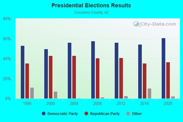
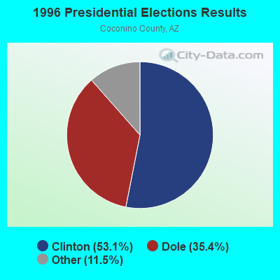
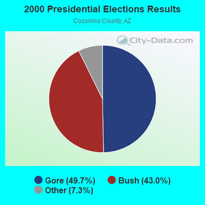
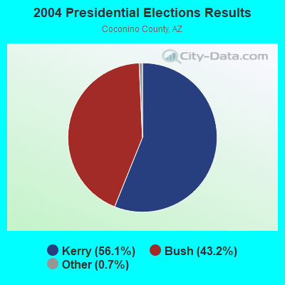
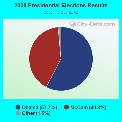
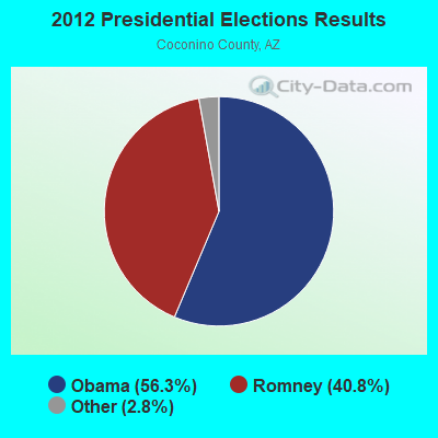
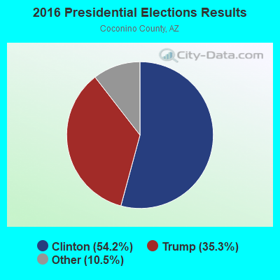
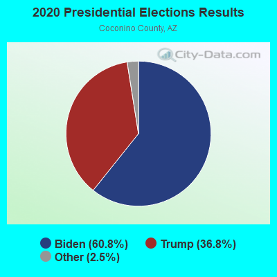
Graphs represent county-level data. Detailed 2008 Election Results
Religion statistics for Havasupai, AZ (based on Coconino County data)
| Religion | Adherents | Congregations |
|---|---|---|
| Other | 18,297 | 54 |
| Evangelical Protestant | 10,785 | 98 |
| Catholic | 6,750 | 9 |
| Mainline Protestant | 3,756 | 18 |
| Black Protestant | 171 | 2 |
| Orthodox | 150 | 1 |
| None | 94,512 | - |
Food Environment Statistics:
| Coconino County: | 1.57 / 10,000 pop. |
| Arizona: | 1.36 / 10,000 pop. |
| This county: | 0.08 / 10,000 pop. |
| Arizona: | 0.14 / 10,000 pop. |
| Coconino County: | 0.47 / 10,000 pop. |
| State: | 0.55 / 10,000 pop. |
| Coconino County: | 5.65 / 10,000 pop. |
| Arizona: | 2.47 / 10,000 pop. |
| Coconino County: | 12.72 / 10,000 pop. |
| Arizona: | 6.21 / 10,000 pop. |
| This county: | 6.8% |
| Arizona: | 8.0% |
| Coconino County: | 21.5% |
| Arizona: | 22.8% |
| This county: | 8.3% |
| Arizona: | 14.2% |
Strongest AM radio stations in Havasupai:
- KDWN (720 AM; 50 kW; LAS VEGAS, NV; Owner: RADIO NEVADA CORP.)
- KXNT (840 AM; 50 kW; NORTH LAS VEGAS, NV; Owner: INFINITY RADIO OPERATIONS INC.)
- KMIA (710 AM; 50 kW; BLACK CANYON CITY, AZ; Owner: ENTRAVISION HOLDINGS, LLC)
- KYET (1180 AM; 10 kW; WILLIAMS, AZ; Owner: GRAND CANYON GATEWAY BROADCASTING, LLC)
- KTNN (660 AM; 50 kW; WINDOW ROCK, AZ; Owner: THE NAVAJO NATION)
- KFNX (1100 AM; 50 kW; CAVE CREEK, AZ; Owner: NORTH AMERICAN BROADCASTING CO., INC.)
- KDXU (890 AM; 10 kW; ST. GEORGE, UT; Owner: WESTERN BROADCASTING, LS, LLC)
- KHAC (880 AM; 43 kW; TSE BONITO, NM; Owner: WESTERN INDIAN MINISTRIES, INC.)
- KUNF (1210 AM; 10 kW; WASHINGTON, UT; Owner: MARATHON MEDIA GROUP, L.L.C.)
- KPXQ (1360 AM; 50 kW; GLENDALE, AZ; Owner: COMMON GROUND BROADCASTING, INC.)
- KZNU (1450 AM; 10 kW; ST. GEORGE, UT; Owner: AM RADIO 1450, INC.)
- KMIK (1580 AM; 50 kW; TEMPE, AZ; Owner: ABC, INC.)
- KFLT (830 AM; 50 kW; TUCSON, AZ; Owner: FAMILY LIFE B/CING SYSTEM, INC.)
Strongest FM radio stations in Havasupai:
- KNAG (90.3 FM; GRAND CANYON, AZ; Owner: ARIZONA BOARD OF REGENTS/NORTHERN ARIZONA UNIVERSITY)
- KPLD (101.1 FM; KANAB, UT; Owner: MARATHON MEDIA GROUP, L.L.C.)
- KZHK (95.9 FM; ST. GEORGE, UT; Owner: MARVIN KENT FRANDSEN)
- KJZA (89.5 FM; DRAKE, AZ; Owner: ST. PAUL BIBLE COLLEGE)
- National Bridge Inventory (NBI) Statistics
- 1Number of bridges
- 23ft / 6.6mTotal length
- 4,730Total average daily traffic
- 473Total average daily truck traffic
- 4,740Total future (year 2038) average daily traffic

- 61.2%Wood
- 28.4%Electricity
- 10.4%Bottled, tank, or LP gas

- 57.6%Wood
- 35.6%Electricity
- 6.8%Other fuel
Havasupai compared to Arizona state average:
- Median household income significantly below state average.
- Median house value significantly below state average.
- Black race population percentage significantly below state average.
- Hispanic race population percentage significantly below state average.
- Median age significantly below state average.
- Foreign-born population percentage significantly below state average.
- Renting percentage below state average.
- Length of stay since moving in significantly above state average.
- Number of rooms per house significantly below state average.
- House age significantly below state average.
- Percentage of population with a bachelor's degree or higher significantly below state average.
Havasupai on our top lists:
- #1 on the list of "Top 101 cities with the least people driving a car to work alone (population 500+)"
- #42 on the list of "Top 101 cities with the least cars per house, population 500+"
- #42 on the list of "Top 100 cities with longest commuting times"
- #25 (86435) on the list of "Top 101 zip codes with the largest percentage of German first ancestries"
- #4 on the list of "Top 101 counties with the highest Ozone (1-hour) air pollution readings in 2012 (ppm)"
- #33 on the list of "Top 101 counties with the lowest Particulate Matter (PM2.5) Annual air pollution readings in 2012 (µg/m3)"
- #43 on the list of "Top 101 counties with the largest decrease in the number of births per 1000 residents 2000-2006 to 2007-2013 (pop 50,000+)"
- #44 on the list of "Top 101 counties with the lowest number of deaths per 1000 residents 2007-2013 (pop. 50,000+)"
- #57 on the list of "Top 101 counties with the highest Particulate Matter (PM10) Annual air pollution readings in 2012 (µg/m3)"