Henderson-Spring Hill, Alabama
Submit your own pictures of this place and show them to the world
- OSM Map
- Google Map
- MSN Map
| Males: 1,463 | |
| Females: 1,584 |
| Median resident age: | 34.4 years |
| Alabama median age: | 35.8 years |
Zip code: 36079
| Henderson-Spring Hill: | $46,321 |
| AL: | $59,674 |
Estimated per capita income in 2022: $30,946 (it was $17,062 in 2000)
Henderson-Spring Hill CCD income, earnings, and wages data
Estimated median house or condo value in 2022: $141,243 (it was $50,800 in 2000)
| Henderson-Spring Hill: | $141,243 |
| AL: | $200,900 |
Henderson-Spring Hill, AL residents, houses, and apartments details
Detailed information about poverty and poor residents in Henderson-Spring Hill, AL
Compare current foreclosures near your location:
| Photo | Address | Area | Beds / Baths | Price | Details |
|---|---|---|---|---|---|

|
#1
Bayberry Cir
Columbus, OH 43207
|
1,564 sq. feet
|
1 baths 3 beds |
$127,500
|
show details |

|
#2
E 21st Ave
Columbus, OH 43211
|
1,061 sq. feet
|
1 baths 3 beds |
$187,900
|
show details |

|
#3
1 2 Sullivant Avenue
Columbus, OH 43204
|
2,288 sq. feet
|
2 baths 4 beds |
show details | |

|
#4
Arborlee Dr
Reynoldsburg, OH 43068
|
1,263 sq. feet
|
2 baths 3 beds |
show details | |

|
#5
N Roys Ave
Columbus, OH 43204
|
1,248 sq. feet
|
2 baths 3 beds |
show details | |

|
#6
Meadowbrook Dr
Columbus, OH 43207
|
1,752 sq. feet
|
2 baths 4 beds |
show details | |

|
#7
S Chillicothe St
Plain City, OH 43064
|
1,736 sq. feet
|
2 baths 4 beds |
show details | |

|
#8
High Free Pike
West Jefferson, OH 43162
|
1,216 sq. feet
|
2 baths 4 beds |
show details | |

|
#9
Stone Shadow Dr
Blacklick, OH 43004
|
1,640 sq. feet
|
2 baths 3 beds |
show details | |

|
#10
Gladiolus Ct
Reynoldsburg, OH 43068
|
2,208 sq. feet
|
2 baths 3 beds |
show details |
| Photo | Address | Area | Beds / Baths | Price | Details |
|---|---|---|---|---|---|

|
#11
Bretton Pl
Columbus, OH 43211
|
1,056 sq. feet
|
1 baths 3 beds |
show details | |

|
#12
Jennybrook Ln
Hilliard, OH 43026
|
2,218 sq. feet
|
3 baths 3 beds |
show details | |

|
#13
Mink St SW
Pataskala, OH 43062
|
1,442 sq. feet
|
1 baths 3 beds |
show details | |

|
#14
Franklin Ave
Columbus, OH 43205
|
2,925 sq. feet
|
2 baths 4 beds |
show details | |

|
#15
S Richardson Ave
Columbus, OH 43204
|
1,520 sq. feet
|
2 baths 3 beds |
show details | |

|
#16
Vineyard Haven Loop
Dublin, OH 43016
|
4,625 sq. feet
|
4 baths 4 beds |
show details | |

|
#17
Belle Oak Dr
Galloway, OH 43119
|
1,296 sq. feet
|
2 baths 3 beds |
show details | |

|
#18
Blue Lake Ave
Galloway, OH 43119
|
1,540 sq. feet
|
2 baths 3 beds |
show details | |

|
#19
Olentangy St
Columbus, OH 43202
|
1,216 sq. feet
|
1 baths 3 beds |
show details | |

|
#20
Mayflower Blvd
Columbus, OH 43213
|
1,591 sq. feet
|
2 baths 4 beds |
show details |
| Photo | Address | Area | Beds / Baths | Price | Details |
|---|---|---|---|---|---|

|
#21
Falls Peak Ln
Delaware, OH 43015
|
1,352 sq. feet
|
2 baths 2 beds |
show details | |

|
#22
Spohn Dr
Westerville, OH 43081
|
1,040 sq. feet
|
1 baths 3 beds |
show details | |

|
#23
Wrexham Ave
Columbus, OH 43223
|
1,235 sq. feet
|
1 baths 3 beds |
show details | |

|
#24
N Grener Ave
Columbus, OH 43228
|
1,120 sq. feet
|
1 baths 3 beds |
show details | |

|
#25
E Welch Ave
Columbus, OH 43207
|
1,864 sq. feet
|
2 baths 3 beds |
show details | |

|
#26
Elaine Rd
Columbus, OH 43213
|
764 sq. feet
|
1 baths 2 beds |
show details | |

|
#27
Hiawatha Park Dr
Columbus, OH 43211
|
1,278 sq. feet
|
1 baths 4 beds |
show details | |

|
#28
S Hague Ave
Columbus, OH 43204
|
979 sq. feet
|
1 baths 2 beds |
show details | |

|
#29
S Ashburton Rd
Columbus, OH 43213
|
1,220 sq. feet
|
1 baths 3 beds |
show details | |

|
#30
Sleeping Meadow Dr
New Albany, OH 43054
|
3,211 sq. feet
|
2 baths 4 beds |
show details |
| Photo | Address | Area | Beds / Baths | Price | Details |
|---|---|---|---|---|---|

|
#31
Lynn Cir
Grove City, OH 43123
|
936 sq. feet
|
1 baths 3 beds |
show details | |

|
#32
Mango Ln
Hilliard, OH 43026
|
1,024 sq. feet
|
1 baths 2 beds |
show details | |

|
#33
Nantucket Ave
Columbus, OH 43235
|
1,864 sq. feet
|
2 baths 3 beds |
show details | |

|
#34
Messner Dr
Hilliard, OH 43026
|
832 sq. feet
|
1 baths 2 beds |
show details | |

|
#35
Maroon Dr
Powell, OH 43065
|
1,198 sq. feet
|
2 baths 3 beds |
show details | |

|
#36
Falene Pl
Galloway, OH 43119
|
1,178 sq. feet
|
1 baths 3 beds |
show details | |

|
#37
Fairlane Rd
Columbus, OH 43207
|
1,550 sq. feet
|
1 baths 4 beds |
show details | |

|
#38
Royal Farm E
Blacklick, OH 43004
|
2,425 sq. feet
|
2 baths 3 beds |
show details | |

|
#39
Grayfriars Ln
Columbus, OH 43224
|
1,256 sq. feet
|
2 baths 3 beds |
show details | |

|
#40
W Kanawha Ave
Columbus, OH 43214
|
656 sq. feet
|
1 baths 1 beds |
show details |
| Photo | Address | Area | Beds / Baths | Price | Details |
|---|---|---|---|---|---|

|
#41
Darbyshire Dr
Hilliard, OH 43026
|
1,775 sq. feet
|
2 baths 3 beds |
show details | |

|
#42
Edgewyn Ave
Hilliard, OH 43026
|
900 sq. feet
|
1 baths 3 beds |
show details | |

|
#43
Stephen St
Grove City, OH 43123
|
1,027 sq. feet
|
1 baths 3 beds |
show details | |

|
#44
Autumn Wind Dr
Grove City, OH 43123
|
1,697 sq. feet
|
2 baths 3 beds |
show details | |

|
#45
Almont Dr
Columbus, OH 43229
|
1,563 sq. feet
|
2 baths 5 beds |
show details | |

|
#46
E Kanawha Ave
Columbus, OH 43214
|
1,230 sq. feet
|
1 baths 3 beds |
show details | |

|
#47
Windy Hill Ln
Galloway, OH 43119
|
1,350 sq. feet
|
2 baths 3 beds |
show details | |

|
#48
Leap Rd
Hilliard, OH 43026
|
1,352 sq. feet
|
1 baths 3 beds |
show details | |

|
#49
Conway Dr
Columbus, OH 43227
|
1,232 sq. feet
|
1 baths 3 beds |
show details | |

|
Check over 1 million property listings on Foreclosure.com!
|
browse all offers | |||

- 2,02867.6%White alone
- 84528.1%Black alone
- 521.7%American Indian alone
- 411.4%Hispanic
- 341.1%Two or more races
- 10.03%Native Hawaiian and Other
Pacific Islander alone - 10.03%Other race alone

 Recent articles from our blog. Our writers, many of them Ph.D. graduates or candidates, create easy-to-read articles on a wide variety of topics.

Current Local Time: CST time zone
Land area: 114.2 square miles.
Population density: 27 people per square mile (very low).
| Henderson-Spring Hill CCD: | 0.4% ($199) |
| Alabama: | 0.4% ($289) |
Nearest city with pop. 50,000+: Dothan, AL  (48.2 miles , pop. 57,737).
Nearest city with pop. 200,000+: Montgomery, AL (49.3 miles , pop. 201,568).
Nearest city with pop. 1,000,000+: Houston, TX (571.8 miles , pop. 1,953,631).
Nearest cities:
), ), ), ), )Latitude: 31.68 N, Longitude: 86.03 W
Area code commonly used in this area: 334

| Here: | 3.2% |
| Alabama: | 2.6% |

- Construction (11.6%)
- Educational services (8.0%)
- Health care (7.3%)
- Agriculture, forestry, fishing & hunting (6.4%)
- Food & beverage stores (5.9%)
- Department & other general merchandise stores (5.4%)
- Food (4.5%)

- Construction (20.8%)
- Agriculture, forestry, fishing & hunting (10.4%)
- Plastics & rubber products (6.8%)
- Truck transportation (5.7%)
- Wood products (5.6%)
- Public administration (5.1%)
- Other transportation, support activities, couriers (4.3%)

- Health care (14.0%)
- Educational services (12.9%)
- Food & beverage stores (9.6%)
- Department & other general merchandise stores (7.6%)
- Food (6.9%)
- Finance & insurance (6.5%)
- Accommodation & food services (4.5%)

- Other production occupations, including supervisors (7.1%)
- Secretaries and administrative assistants (6.6%)
- Driver/sales workers and truck drivers (5.6%)
- Cashiers (5.2%)
- Building and grounds cleaning and maintenance occupations (5.1%)
- Cooks and food preparation workers (4.0%)
- Electrical equipment mechanics and other installation, maintenance, and repair workers, including supervisors (3.4%)

- Driver/sales workers and truck drivers (10.4%)
- Other production occupations, including supervisors (9.5%)
- Electrical equipment mechanics and other installation, maintenance, and repair workers, including supervisors (6.2%)
- Construction traders workers except carpenters, electricians, painters, plumbers, and construction laborers (5.9%)
- Farmers and farm managers (4.7%)
- Engineers (4.5%)
- Painters and paperhangers (4.3%)

- Secretaries and administrative assistants (14.4%)
- Cashiers (11.3%)
- Building and grounds cleaning and maintenance occupations (7.1%)
- Cooks and food preparation workers (5.6%)
- Information and record clerks, except customer service representatives (5.1%)
- Nursing, psychiatric, and home health aides (5.1%)
- Other production occupations, including supervisors (4.4%)
Average climate in Henderson-Spring Hill, Alabama
Based on data reported by over 4,000 weather stations


(lower is better)

Lead (Pb) [µg/m3] level in 2007 was 0.230. This is significantly worse than average. Closest monitor was 8.2 miles away from the city center.
| City: | 0.230 |
| U.S.: | 0.009 |
Tornado activity:
Henderson-Spring Hill-area historical tornado activity is slightly below Alabama state average. It is 45% greater than the overall U.S. average.
On 3/2/1971, a category F3 (max. wind speeds 158-206 mph) tornado 3.3 miles away from the Henderson-Spring Hill place center caused between $5000 and $50,000 in damages.
On 3/1/2007, a category F4 (max. wind speeds 207-260 mph) tornado 28.5 miles away from the place center killed 9 people and injured 50 people and caused $250 million in damages.
Earthquake activity:
Henderson-Spring Hill-area historical earthquake activity is significantly above Alabama state average. It is 35% greater than the overall U.S. average.On 10/24/1997 at 08:35:17, a magnitude 4.9 (4.8 MB, 4.2 MS, 4.9 LG, Depth: 6.2 mi, Class: Light, Intensity: IV - V) earthquake occurred 83.1 miles away from Henderson-Spring Hill center
On 1/18/1999 at 07:00:53, a magnitude 4.8 (4.8 MB, 4.0 LG, Depth: 0.6 mi) earthquake occurred 139.1 miles away from the city center
On 4/29/2003 at 08:59:39, a magnitude 4.9 (4.4 MB, 4.6 MW, 4.9 LG) earthquake occurred 195.9 miles away from the city center
On 11/7/2004 at 11:20:21, a magnitude 4.3 (4.3 MW, Depth: 3.1 mi) earthquake occurred 130.2 miles away from Henderson-Spring Hill center
On 6/24/1975 at 11:11:36, a magnitude 4.5 (4.5 MB) earthquake occurred 176.1 miles away from the city center
On 4/29/2003 at 08:59:39, a magnitude 4.6 (4.6 MW, Depth: 12.3 mi) earthquake occurred 195.9 miles away from Henderson-Spring Hill center
Magnitude types: regional Lg-wave magnitude (LG), body-wave magnitude (MB), surface-wave magnitude (MS), moment magnitude (MW)
Natural disasters:
The number of natural disasters in Pike County (16) is near the US average (15).Major Disasters (Presidential) Declared: 9
Emergencies Declared: 5
Causes of natural disasters: Storms: 7, Hurricanes: 6, Floods: 5, Tornadoes: 5, Winds: 3, Drought: 1, Snowfall: 1, Winter Storm: 1, Other: 1 (Note: some incidents may be assigned to more than one category).
Hospitals and medical centers near Henderson-Spring Hill:
- TROY HEALTH AND REHABILITATION CENTER (Nursing Home, about 8 miles away; TROY, AL)
- FMC TROY (Dialysis Facility, about 9 miles away; TROY, AL)
- PIKE COUNTY HOME CARE (Home Health Center, about 9 miles away; TROY, AL)
- LIGHTHOUSE HOSPICE OF ALABAMA, LLC (Hospital, about 10 miles away; TROY, AL)
- LUVERNE HEALTH AND REHABILITATION, LLC (Nursing Home, about 15 miles away; LUVERNE, AL)
Colleges/universities with over 2000 students nearest to Henderson-Spring Hill:
- Troy University (about 10 miles; Troy, AL; Full-time enrollment: 16,148)
- Enterprise State Community College (about 29 miles; Enterprise, AL; FT enrollment: 2,101)
- George C Wallace State Community College-Dothan (about 42 miles; Dothan, AL; FT enrollment: 3,611)
- Auburn University at Montgomery (about 49 miles; Montgomery, AL; FT enrollment: 4,092)
- Alabama State University (about 50 miles; Montgomery, AL; FT enrollment: 5,457)
- Faulkner University (about 50 miles; Montgomery, AL; FT enrollment: 2,887)
- Tuskegee University (about 56 miles; Tuskegee, AL; FT enrollment: 2,810)
Points of interest:
Notable locations in Henderson-Spring Hill: County Line (A), Camp Sharon Campground (B), Spring Hill Volunteer Fire Department (C), Henderson Volunteer Fire Department (D). Display/hide their locations on the map
Churches in Henderson-Spring Hill include: New Mount Zion Church (A), Mount Hillard Church (B), Turner Chapel (C), White Rock Church (D), Bethel Church (E), Center Ridge Church (F), Henderson Church (G), Spring Hill Church (H), Elam Church (I). Display/hide their locations on the map
Cemeteries: Spears Cemetery (1), Old Salem Cemetery (2), Mount Zion Cemetery (3), Ballard Hill Cemetery (4), Boutwell-Bundy Cemetery (5), Davis Cemetery (6), Henderson Cemetery (7). Display/hide their locations on the map
Lakes and reservoirs: Mandy Warren Lake (A), Gibson Pond (B), Stewarts Pond (C), Loflins Pond (D), Shaver Pond (E), Whiteheads Pond (F), Pearsons Pond (G), Norris Pond (H). Display/hide their locations on the map
Streams, rivers, and creeks: Thunder Spring Creek (A), Tenmile Branch (B), Smilies Mill Creek (C), Smart Branch (D), Silers Mill Creek (E), Sanders Creek (F), Parks Branch (G), Dugans Branch (H), Dolton Branch (I). Display/hide their locations on the map
| This place: | 2.4 people |
| Alabama: | 2.5 people |
| This place: | 68.6% |
| Whole state: | 67.8% |
| This place: | 4.0% |
| Whole state: | 4.7% |
Likely homosexual households (counted as self-reported same-sex unmarried-partner households)
- Lesbian couples: 0.3% of all households
- Gay men: 0.3% of all households
| This place: | 22.7% |
| Whole state: | 16.1% |
| This place: | 8.8% |
| Whole state: | 7.3% |
For population 15 years and over in Henderson-Spring Hill:

- Never married: 23.9%
- Now married: 59.0%
- Separated: 4.0%
- Widowed: 7.6%
- Divorced: 9.6%
For population 25 years and over in Henderson-Spring Hill:
- High school or higher: 55.2%
- Bachelor's degree or higher: 9.8%
- Graduate or professional degree: 4.4%
- Unemployed: 6.9%
- Mean travel time to work (commute): 22.2 minutes


| Here: | 15.6 |
| Alabama average: | 13.2 |
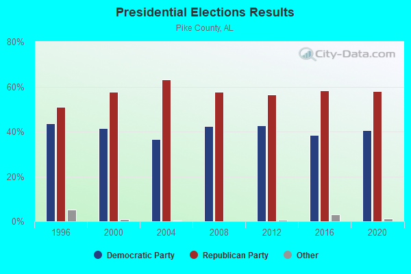
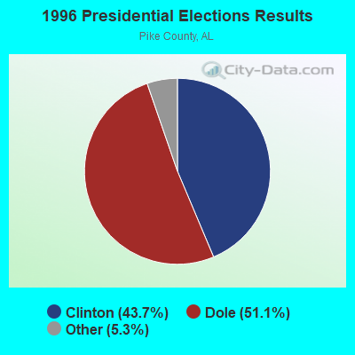
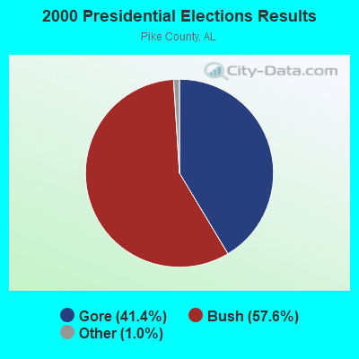

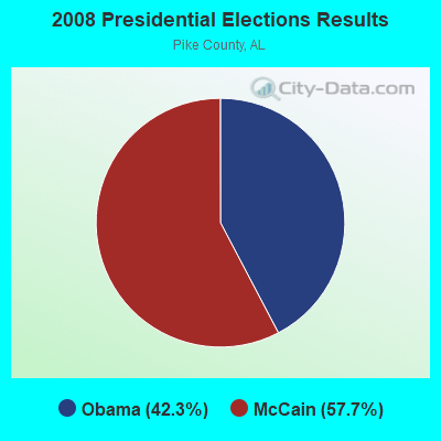
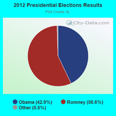
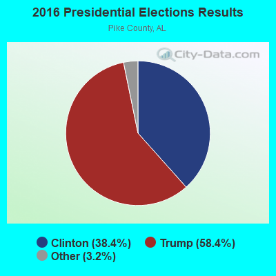
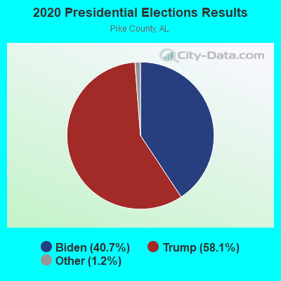
Graphs represent county-level data. Detailed 2008 Election Results
Religion statistics for Henderson-Spring Hill, AL (based on Pike County data)
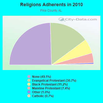
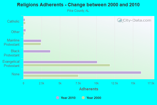
| Religion | Adherents | Congregations |
|---|---|---|
| Evangelical Protestant | 10,098 | 52 |
| Black Protestant | 3,675 | 19 |
| Mainline Protestant | 2,442 | 14 |
| Other | 325 | 3 |
| Catholic | 215 | 1 |
| None | 16,144 | - |
Food Environment Statistics:
| Pike County: | 2.65 / 10,000 pop. |
| State: | 1.89 / 10,000 pop. |
| Pike County: | 0.33 / 10,000 pop. |
| Alabama: | 0.20 / 10,000 pop. |
| This county: | 0.66 / 10,000 pop. |
| Alabama: | 0.65 / 10,000 pop. |
| This county: | 5.30 / 10,000 pop. |
| State: | 6.32 / 10,000 pop. |
| Pike County: | 5.63 / 10,000 pop. |
| Alabama: | 5.75 / 10,000 pop. |
| This county: | 12.2% |
| State: | 11.8% |
| Pike County: | 36.7% |
| Alabama: | 31.7% |
| Pike County: | 14.4% |
| Alabama: | 13.5% |
Strongest AM radio stations in Henderson-Spring Hill:
- WTBF (970 AM; 5 kW; TROY, AL; Owner: TROY BROADCASTING CORP.)
- WQLS (1200 AM; 10 kW; OZARK, AL; Owner: STYLES BROADCASTING OF DOTHAN, INC.)
- WMSP (740 AM; 10 kW; MONTGOMERY, AL; Owner: CUMULUS LICENSING CORP.)
- WASG (550 AM; 25 kW; ATMORE, AL; Owner: 550 AM, INC)
- WJOX (690 AM; 50 kW; BIRMINGHAM, AL; Owner: CITADEL BROADCASTING COMPANY)
- WTKN (1560 AM; daytime; 5 kW; DALEVILLE, AL; Owner: JOSEPH A. ADAMS, SR.)
- WOOF (560 AM; 5 kW; DOTHAN, AL; Owner: WOOF, INC.)
- WELB (1350 AM; 1 kW; ELBA, AL; Owner: ELBA RADIO COMPANY)
- WDJC (850 AM; 50 kW; BIRMINGHAM, AL; Owner: KIMTRON, INC.)
- WACV (1170 AM; 10 kW; MONTGOMERY, AL; Owner: MONTGOMERY BROADCAST PROPERTIES, LTD)
- WNSI (810 AM; 50 kW; JACKSONVILLE, AL; Owner: UNITED BROADCASTING NETWORK, INC.)
- WGST (640 AM; 50 kW; ATLANTA, GA; Owner: CITICASTERS LICENSES, L.P.)
- WAPI (1070 AM; 50 kW; BIRMINGHAM, AL; Owner: CITADEL BROADCASTING COMPANY)
Strongest FM radio stations in Henderson-Spring Hill:
- WAXU (91.1 FM; TROY, AL; Owner: AMERICAN FAMILY ASSOCIATION)
- WQLD (104.3 FM; LUVERNE, AL; Owner: CAPSTAR TX LIMITED PARTNERSHIP)
- WZHT (105.7 FM; TROY, AL; Owner: CAPSTAR TX LIMITED PARTNERSHIP)
- WTBF-FM (94.7 FM; BRUNDIDGE, AL; Owner: TROY BROADCASTING CORPORATION)
- WKMX (106.7 FM; ENTERPRISE, AL; Owner: WKMX, INC.)
- WAOQ (100.3 FM; BRANTLEY, AL; Owner: ALATRON CORPORATION, INC.)
- WZTZ (101.1 FM; ELBA, AL; Owner: ELBA RADIO COMPANY)
- WLWI-FM (92.3 FM; MONTGOMERY, AL; Owner: CUMULUS LICENSING CORP.)
- WTSU (89.9 FM; MONTGOMERY-TROY, AL; Owner: TROY STATE UNIVERSITY)
- WAPR (88.3 FM; SELMA, AL; Owner: UA-ASU-TSU EDUCATIONAL RADIO CORP.)
TV broadcast stations around Henderson-Spring Hill:
- WRJM-TV (Channel 67; TROY, AL; Owner: JOSIE PARK BROADCASTING, INC.)
- WSFA (Channel 12; MONTGOMERY, AL; Owner: LIBCO, INC.)
- WCOV-TV (Channel 20; MONTGOMERY, AL; Owner: WOODS COMMUNICATIONS CORPORATION)
- WDIQ (Channel 2; DOZIER, AL; Owner: ALABAMA EDUCATIONAL TELEVISION COMMISSION)
- WNCF (Channel 32; MONTGOMERY, AL; Owner: CHANNEL 32 MONTGOMERY LLC)
- WTVY (Channel 4; DOTHAN, AL; Owner: GRAY MIDAMERICA TV LICENSEE CORP.)
- WAKA (Channel 8; SELMA, AL; Owner: ALABAMA BROADCASTING PARTNERS)
- WGIQ (Channel 43; LOUISVILLE, AL; Owner: ALABAMA EDUCATIONAL TELEVISION COMMISSION)
- WDFX-TV (Channel 34; OZARK, AL; Owner: WAITT LICENSE CO. OF ALABAMA, L.L.C.)

- 54.1%Electricity
- 31.8%Bottled, tank, or LP gas
- 11.3%Utility gas
- 1.0%Fuel oil, kerosene, etc.
- 0.9%No fuel used
- 0.7%Wood
- 0.2%Other fuel

- 54.4%Electricity
- 29.6%Bottled, tank, or LP gas
- 12.4%Utility gas
- 1.8%Fuel oil, kerosene, etc.
- 1.8%Wood
Henderson-Spring Hill compared to Alabama state average:
- Unemployed percentage below state average.
- Hispanic race population percentage significantly below state average.
- Median age significantly below state average.
- Foreign-born population percentage significantly below state average.
- Length of stay since moving in significantly above state average.
- Number of rooms per house significantly below state average.
- House age significantly below state average.
- Percentage of population with a bachelor's degree or higher below state average.