Hermitage Springs, Tennessee
Submit your own pictures of this place and show them to the world
- OSM Map
- General Map
- Google Map
- MSN Map

| Males: 1,402 | |
| Females: 1,427 |
| Median resident age: | 38.7 years |
| Tennessee median age: | 35.9 years |
Zip code: 37150
| Hermitage Springs: | $43,729 |
| TN: | $65,254 |
Estimated per capita income in 2022: $23,420 (it was $13,358 in 2000)
Hermitage Springs CCD income, earnings, and wages data
Estimated median house or condo value in 2022: $152,207 (it was $48,400 in 2000)
| Hermitage Springs: | $152,207 |
| TN: | $284,800 |
Mean prices in 2022: all housing units: $192,458; detached houses: $215,354; townhouses or other attached units: $190,501; mobile homes: $63,525
Hermitage Springs, TN residents, houses, and apartments details
Detailed information about poverty and poor residents in Hermitage Springs, TN
Compare current foreclosures near Hermitage Springs, TN:
| Photo | Address | Area | Beds / Baths | Price | Details |
|---|---|---|---|---|---|

|
#1
Morgan Rd
Lafayette, TN 37083
|
1,680 sq. feet
|
2 baths 4 beds |
show details | |

|
#2
Christie Cir
Red Boiling Springs, TN 37150
|
897 sq. feet
|
1 baths 3 beds |
show details | |

|
#3
Edgewood St
Lafayette, TN 37083
|
1,152 sq. feet
|
2 baths 3 beds |
show details | |

|
#4
Sulphur Lick Rd
Tompkinsville, KY 42167
|
1,716 sq. feet
|
4 baths 3 beds |
show details | |

|
#5
S Main St
Tompkinsville, KY 42167
|
1,072 sq. feet
|
1 baths 2 beds |
show details | |

|
#6
Christie Cir
Red Boiling Springs, TN 37150
|
989 sq. feet
|
1 baths - beds |
show details | |

|
#7
Riley Creek Rd
Whitleyville, TN 38588
|
1,872 sq. feet
|
2 baths - beds |
show details | |

|
#8
Galen Rd
Lafayette, TN 37083
|
1,056 sq. feet
|
3 baths - beds |
show details | |

|
#9
Kristen Dr
Lafayette, TN 37083
|
1,144 sq. feet
|
2 baths - beds |
show details | |

|
#10
Indian Creek Rd
Whitleyville, TN 38588
|
644 sq. feet
|
1 baths - beds |
show details |
| Photo | Address | Area | Beds / Baths | Price | Details |
|---|---|---|---|---|---|

|
#11
Long Fork Creek Rd
Lafayette, TN 37083
|
1,412 sq. feet
|
1 baths - beds |
show details | |

|
#12
Trent Rd
Lafayette, TN 37083
|
1,413 sq. feet
|
2 baths - beds |
show details | |

|
#13
Sugar Creek Rd
Gainesboro, TN 38562
|
2,040 sq. feet
|
1 baths - beds |
show details | |

|
#14
Carthage Rd
Red Boiling Springs, TN 37150
|
1,400 sq. feet
|
2 baths - beds |
show details | |

|
#15
Pleasant Shade Hwy
Pleasant Shade, TN 37145
|
1,568 sq. feet
|
2 baths - beds |
show details | |

|
#16
Akersville Rd
Lafayette, TN 37083
|
3,000 sq. feet
|
2 baths - beds |
show details | |

|
#17
Oak Grove Rd
Red Boiling Springs, TN 37150
|
1,432 sq. feet
|
1 baths - beds |
show details | |

|
#18
Salt Lick Creek Rd
Pleasant Shade, TN 37145
|
2,880 sq. feet
|
1 baths - beds |
show details | |

|
#19
Akersville Rd
Lafayette, TN 37083
|
1,744 sq. feet
|
2 baths - beds |
show details | |

|
#20
Walton Ave
Lafayette, TN 37083
|
1,582 sq. feet
|
1 baths - beds |
show details |
| Photo | Address | Area | Beds / Baths | Price | Details |
|---|---|---|---|---|---|

|
#21
Ernest Phann Ln
Gainesboro, TN 38562
|
876 sq. feet
|
1 baths - beds |
show details | |

|
#22
Turkeytown Rd
Hilham, TN 38568
|
- sq. feet
|
- baths - beds |
show details | |

|
#23
Highway 52 Byp E
Lafayette, TN 37083
|
- sq. feet
|
- baths - beds |
show details | |

|
#24
Happy Springs Rd
Red Boiling Springs, TN 37150
|
- sq. feet
|
- baths - beds |
show details | |

|
#25
Akersville Rd # B
Lafayette, TN 37083
|
- sq. feet
|
- baths - beds |
show details | |

|
#26
Coys Cove Ln
Gainesboro, TN 38562
|
- sq. feet
|
- baths - beds |
show details | |

|
#27
Kimbel Dr
Lafayette, TN 37083
|
- sq. feet
|
- baths - beds |
show details | |

|
#28
Wells Dr # B
Lafayette, TN 37083
|
- sq. feet
|
- baths - beds |
show details | |

|
#29
Days Rd # D
Lafayette, TN 37083
|
- sq. feet
|
- baths - beds |
show details | |

|
#30
Poplar School Rd
Glasgow, KY 42141
|
- sq. feet
|
- baths - beds |
show details |
| Photo | Address | Area | Beds / Baths | Price | Details |
|---|---|---|---|---|---|

|
#31
Homer Bartley Rd
Summer Shade, KY 42166
|
1,680 sq. feet
|
- baths - beds |
show details | |

|
#32
Anders Ln
Lafayette, TN 37083
|
- sq. feet
|
- baths - beds |
show details | |

|
#33
Dog Branch Rd N
Pleasant Shade, TN 37145
|
- sq. feet
|
- baths - beds |
show details | |

|
#34
Cassetty Ln
Gainesboro, TN 38562
|
- sq. feet
|
- baths - beds |
show details | |

|
#35
Miller Rd
Lafayette, TN 37083
|
- sq. feet
|
- baths - beds |
show details | |

|
#36
Dotson Rd
Lafayette, TN 37083
|
- sq. feet
|
- baths - beds |
show details | |

|
#37
Bilbrey St
Red Boiling Springs, TN 37150
|
980 sq. feet
|
- baths - beds |
show details | |

|
#38
Athens Church Rd
Tompkinsville, KY 42167
|
- sq. feet
|
- baths - beds |
show details | |

|
#39
Emile Ln
Tompkinsville, KY 42167
|
- sq. feet
|
- baths - beds |
show details | |

|
#40
Harlans Xrds
Tompkinsville, KY 42167
|
- sq. feet
|
- baths - beds |
show details |
| Photo | Address | Area | Beds / Baths | Price | Details |
|---|---|---|---|---|---|

|
#41
Clay County Hwy
Celina, TN 38551
|
- sq. feet
|
- baths - beds |
show details | |

|
#42
Galen Rd
Lafayette, TN 37083
|
- sq. feet
|
- baths - beds |
show details | |

|
#43
W 5th St
Tompkinsville, KY 42167
|
- sq. feet
|
- baths - beds |
show details | |

|
#44
Mud Lick Flippin Rd
Tompkinsville, KY 42167
|
- sq. feet
|
- baths - beds |
show details | |

|
#45
Billie Collins Ln
Celina, TN 38551
|
- sq. feet
|
- baths - beds |
show details | |

|
#46
Hill Top Ct
Celina, TN 38551
|
- sq. feet
|
- baths - beds |
show details | |

|
#47
County Line Rd
Fountain Run, KY 42133
|
- sq. feet
|
- baths - beds |
show details | |

|
#48
Brookwood Ln # B23
Gainesboro, TN 38562
|
- sq. feet
|
- baths - beds |
show details | |

|
#49
Deer Run Ln # 6
Gainesboro, TN 38562
|
- sq. feet
|
- baths - beds |
show details | |

|
Check over 1 million property listings on Foreclosure.com!
|
browse all offers | |||

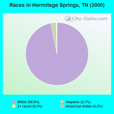
- 2,75996.8%White alone
- 772.7%Hispanic
- 80.3%Two or more races
- 50.2%American Indian alone
- 20.07%Asian alone
Races in Hermitage Springs detailed stats: ancestries, foreign born residents, place of birth
 Recent articles from our blog. Our writers, many of them Ph.D. graduates or candidates, create easy-to-read articles on a wide variety of topics.

Current Local Time: CST time zone
Elevation: 758 feet
Land area: 87.2 square miles.
Population density: 32 people per square mile (very low).

| Hermitage Springs CCD: | 0.7% ($340) |
| Tennessee: | 0.8% ($715) |
Nearest city with pop. 50,000+: Murfreesboro, TN  (61.9 miles , pop. 68,816).
Nearest city with pop. 200,000+: Nashville-Davidson, TN (64.3 miles , pop. 545,524).
Nearest city with pop. 1,000,000+: Chicago, IL (378.7 miles , pop. 2,896,016).
Nearest cities:
), ), ), Latitude: 36.58 N, Longitude: 85.73 W

| Here: | 4.1% |
| Tennessee: | 3.0% |
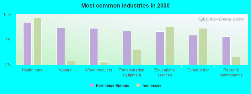
- Health care (8.5%)
- Apparel (7.3%)
- Wood products (7.3%)
- Transportation equipment (6.7%)
- Educational services (6.6%)
- Construction (5.9%)
- Repair & maintenance (5.7%)
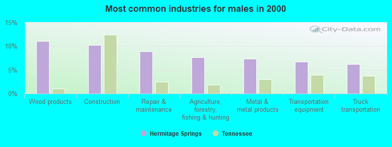
- Wood products (11.1%)
- Construction (10.3%)
- Repair & maintenance (8.9%)
- Agriculture, forestry, fishing & hunting (7.6%)
- Metal & metal products (7.4%)
- Transportation equipment (6.7%)
- Truck transportation (6.2%)
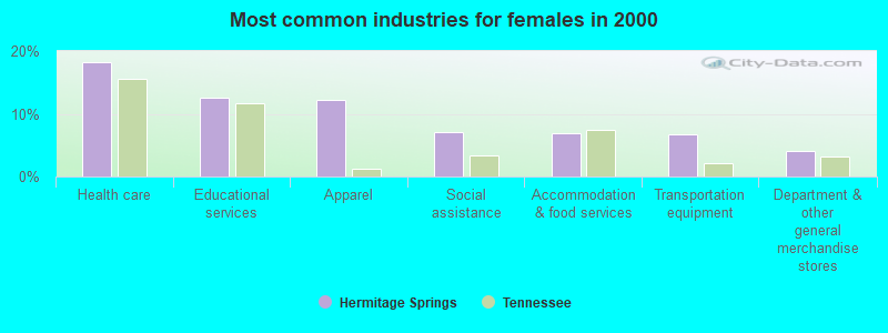
- Health care (18.3%)
- Educational services (12.6%)
- Apparel (12.2%)
- Social assistance (7.1%)
- Accommodation & food services (6.9%)
- Transportation equipment (6.7%)
- Department & other general merchandise stores (4.1%)
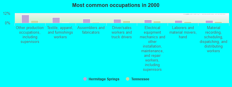
- Other production occupations, including supervisors (10.3%)
- Textile, apparel, and furnishings workers (7.0%)
- Assemblers and fabricators (5.0%)
- Driver/sales workers and truck drivers (4.8%)
- Electrical equipment mechanics and other installation, maintenance, and repair workers, including supervisors (4.1%)
- Laborers and material movers, hand (3.4%)
- Material recording, scheduling, dispatching, and distributing workers (3.1%)
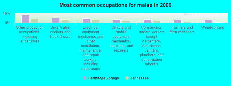
- Other production occupations, including supervisors (13.0%)
- Driver/sales workers and truck drivers (8.3%)
- Electrical equipment mechanics and other installation, maintenance, and repair workers, including supervisors (7.1%)
- Vehicle and mobile equipment mechanics, installers, and repairers (5.1%)
- Construction traders workers except carpenters, electricians, painters, plumbers, and construction laborers (5.1%)
- Farmers and farm managers (5.0%)
- Woodworkers (4.7%)

- Textile, apparel, and furnishings workers (14.5%)
- Other production occupations, including supervisors (6.7%)
- Assemblers and fabricators (5.5%)
- Building and grounds cleaning and maintenance occupations (5.3%)
- Health technologists and technicians (4.6%)
- Material recording, scheduling, dispatching, and distributing workers (4.4%)
- Child care workers (4.1%)
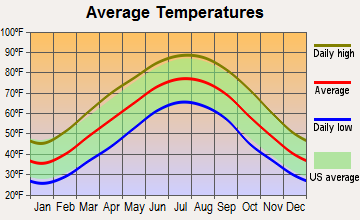
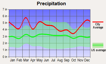
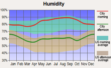
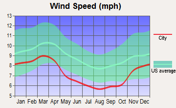
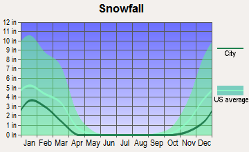
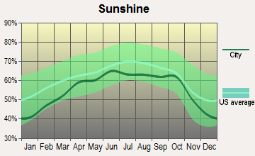
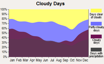
Average climate in Hermitage Springs, Tennessee
Based on data reported by over 4,000 weather stations
Tornado activity:
Hermitage Springs-area historical tornado activity is near Tennessee state average. It is 52% greater than the overall U.S. average.
On 4/3/1974, a category F4 (max. wind speeds 207-260 mph) tornado 20.8 miles away from the Hermitage Springs place center killed 10 people and injured 113 people and caused between $5000 and $50,000 in damages.
On 2/5/2008, a category F3 (max. wind speeds 158-206 mph) tornado 9.4 miles away from the place center caused $4 million in damages.
Earthquake activity:
Hermitage Springs-area historical earthquake activity is significantly above Tennessee state average. It is 143% greater than the overall U.S. average.On 4/18/2008 at 09:36:59, a magnitude 5.4 (5.1 MB, 4.8 MS, 5.4 MW, 5.2 MW, Class: Moderate, Intensity: VI - VII) earthquake occurred 175.4 miles away from Hermitage Springs center
On 7/27/1980 at 18:52:21, a magnitude 5.2 (5.1 MB, 4.7 MS, 5.0 UK, 5.2 UK) earthquake occurred 149.6 miles away from the city center
On 4/18/2008 at 09:36:59, a magnitude 5.2 (5.2 MW, Depth: 8.9 mi) earthquake occurred 175.4 miles away from the city center
On 6/18/2002 at 17:37:15, a magnitude 5.0 (4.3 MB, 4.6 MW, 5.0 LG) earthquake occurred 149.0 miles away from the city center
On 4/29/2003 at 08:59:39, a magnitude 4.9 (4.4 MB, 4.6 MW, 4.9 LG, Class: Light, Intensity: IV - V) earthquake occurred 144.2 miles away from the city center
On 11/30/1973 at 07:48:41, a magnitude 4.7 (4.7 MB, 4.6 ML) earthquake occurred 112.6 miles away from Hermitage Springs center
Magnitude types: regional Lg-wave magnitude (LG), body-wave magnitude (MB), local magnitude (ML), surface-wave magnitude (MS), moment magnitude (MW)
Natural disasters:
The number of natural disasters in Clay County (16) is near the US average (15).Major Disasters (Presidential) Declared: 12
Emergencies Declared: 2
Causes of natural disasters: Floods: 11, Storms: 10, Winter Storms: 3, Tornadoes: 2, Flash Flood: 1, Hurricane: 1, Ice Storm: 1, Landslide: 1, Mudslide: 1, Snowfall: 1, Wind: 1, Other: 1 (Note: some incidents may be assigned to more than one category).
Hospitals and medical centers near Hermitage Springs:
- THE PALACE (Nursing Home, about 8 miles away; RED BOILING SPRINGS, TN)
- MONROE COUNTY MEDICAL CENTER Acute Care Hospitals (about 10 miles away; TOMPKINSVILLE, KY)
- MONROE HEALTH AND REHABILITATION CENTER (Nursing Home, about 10 miles away; TOMPKINSVILLE, KY)
- CELINA HEALTH AND REHABILITATION CENTER (Nursing Home, about 13 miles away; CELINA, TN)
- CUMBERLAND RIVER HOSPITAL Acute Care Hospitals (about 14 miles away; CELINA, TN)
- MABRY HEALTH CARE (Nursing Home, about 15 miles away; GAINESBORO, TN)
Colleges/universities with over 2000 students nearest to Hermitage Springs:
- Tennessee Technological University (about 31 miles; Cookeville, TN; Full-time enrollment: 9,761)
- Lindsey Wilson College (about 44 miles; Columbia, KY; FT enrollment: 2,552)
- Volunteer State Community College (about 45 miles; Gallatin, TN; FT enrollment: 5,311)
- Western Kentucky University (about 50 miles; Bowling Green, KY; FT enrollment: 16,942)
- Southcentral Kentucky Community and Technical College (about 50 miles; Bowling Green, KY; FT enrollment: 2,794)
- Campbellsville University (about 58 miles; Campbellsville, KY; FT enrollment: 2,948)
- Middle Tennessee State University (about 62 miles; Murfreesboro, TN; FT enrollment: 21,628)
Public elementary/middle schools in Hermitage Springs:
- DUPONT TYLER MIDDLE (Students: 763, Location: 431 TYLER DR, Grades: 5-8)
- RUBY MAJOR ELEMENTARY (Students: 636, Location: 5141 JOHN HAGER RD, Grades: KG-4)
- TULIP GROVE ELEMENTARY (Students: 632, Location: 441 TYLER DR, Grades: PK-4)
- DODSON ELEMENTARY (Students: 488, Location: 4401 CHANDLER RD, Grades: PK-4)
- HERMITAGE ELEMENTARY (Students: 329, Location: 3800 PLANTATION DR, Grades: KG-4)
Points of interest:
Notable locations in Hermitage Springs: Running Late Poultry Farm (A), Smith's Poultry Farms (B), Ridge Top Farm (C), Moss Volunteer Fire Department (D), Union Hill Community Center (E), Mount Vernon Volunteer Fire Department Red Boiling Springs (F), Hermitage Springs Volunteer Fire Department (G). Display/hide their locations on the map
Churches in Hermitage Springs include: Leonard Church (A), Wesleyan Church (B), Bakerton Church of Christ (C), Campground Church (D), Clementsville Church of Christ (E), Hermitage Springs Church of Christ (F), Milestown Church of Christ (G), Moss Church of Christ (H), Mount Vernon Charity Tabernacle (I). Display/hide their locations on the map
Cemeteries: Turner Cemetery (1), Jonestown Cemetery (2), Leonard Cemetery (3), Biles Cemetery (4), Reeves Cemetery (5), Browning Cemetery (6), Miles Cemetery (7). Display/hide their locations on the map
Reservoirs: Line Creek Lake Number Three B (A), Lake Site Number Four (B). Display/hide their locations on the map
Streams, rivers, and creeks: Little Brimstone Creek (A), Left Fork Brimstone Creek (B), Cove Creek (C), Hurricane Creek (D), Trace Creek (E), Bean Branch (F), Pide Branch (G), School Branch (H), Wilson Branch (I). Display/hide their locations on the map
| This place: | 2.5 people |
| Tennessee: | 2.5 people |
| This place: | 61.6% |
| Whole state: | 69.8% |
| This place: | 3.9% |
| Whole state: | 4.2% |
Likely homosexual households (counted as self-reported same-sex unmarried-partner households)
- Lesbian couples: 0.2% of all households
- Gay men: 0.2% of all households
| This place: | 15.5% |
| Whole state: | 13.5% |
| This place: | 5.3% |
| Whole state: | 5.8% |
For population 15 years and over in Hermitage Springs:
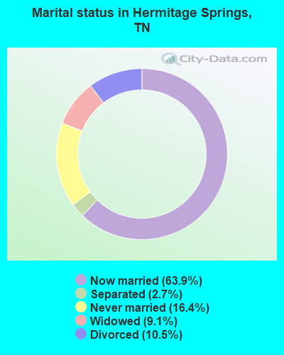
- Never married: 16.4%
- Now married: 63.9%
- Separated: 2.7%
- Widowed: 9.1%
- Divorced: 10.5%
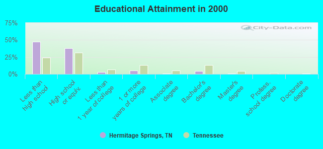
For population 25 years and over in Hermitage Springs:
- High school or higher: 52.4%
- Bachelor's degree or higher: 5.9%
- Graduate or professional degree: 1.5%
- Unemployed: 6.6%
- Mean travel time to work (commute): 31.3 minutes
| Here: | 16.7 |
| Tennessee average: | 13.3 |
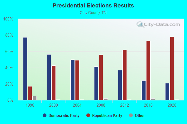
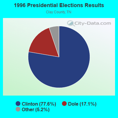
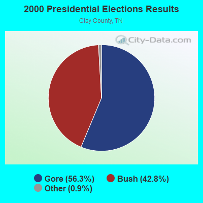


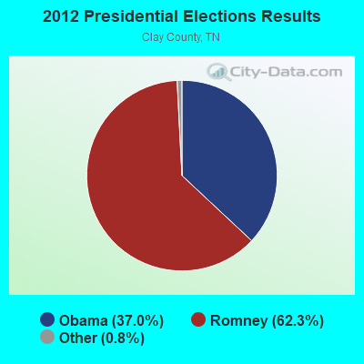


Graphs represent county-level data. Detailed 2008 Election Results
Religion statistics for Hermitage Springs, TN (based on Clay County data)
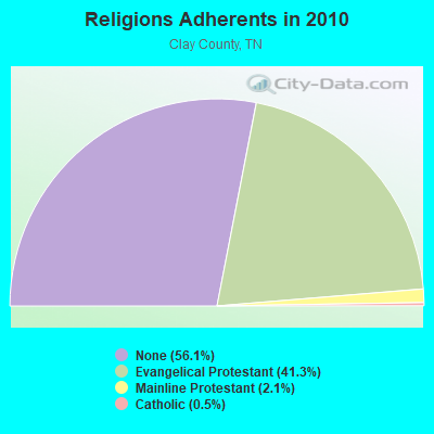
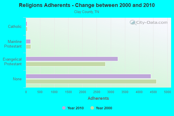
| Religion | Adherents | Congregations |
|---|---|---|
| Evangelical Protestant | 3,246 | 29 |
| Mainline Protestant | 164 | 1 |
| Catholic | 40 | 1 |
| None | 4,411 | - |
Food Environment Statistics:
| Clay County: | 2.55 / 10,000 pop. |
| Tennessee: | 1.99 / 10,000 pop. |
| Here: | 7.65 / 10,000 pop. |
| Tennessee: | 5.16 / 10,000 pop. |
| Clay County: | 6.37 / 10,000 pop. |
| Tennessee: | 6.56 / 10,000 pop. |
| This county: | 11.7% |
| Tennessee: | 11.4% |
| Clay County: | 31.6% |
| Tennessee: | 30.2% |
| Here: | 17.3% |
| Tennessee: | 13.5% |
Strongest AM radio stations in Hermitage Springs:
- WSM (650 AM; 50 kW; NASHVILLE, TN; Owner: GAYLORD ENTERTAINMENT COMPANY)
- WTKY (1370 AM; daytime; 2 kW; TOMPKINSVILLE, KY; Owner: WHITTIMORE ENTERPRISES, INC.)
- WAMB (1160 AM; 50 kW; DONELSON, TN; Owner: GREAT SOUTHERN BROADCASTING COMPANY, INC.)
- WLAC (1510 AM; 50 kW; NASHVILLE, TN; Owner: CAPSTAR TX LIMITED PARTNERSHIP)
- WKDA (1200 AM; 50 kW; NASHVILLE, TN; Owner: RADIO NASHVILLE, INC.)
- WNQM (1300 AM; 50 kW; NASHVILLE, TN; Owner: WNQM. INC.)
- WWAM (820 AM; daytime; 50 kW; JASPER, TN; Owner: SHELTON BROADCASTING SYSTEM)
- WKVL (850 AM; daytime; 50 kW; KNOXVILLE, TN; Owner: HORNE RADIO, LLC)
- WHAS (840 AM; 50 kW; LOUISVILLE, KY; Owner: CLEAR CHANNEL BROADCASTING LICENSES, INC.)
- WFLI (1070 AM; 50 kW; LOOKOUT MOUNTAIN, TN; Owner: WFLI, INC.)
- WPLN (1430 AM; 15 kW; MADISON, TN)
- WHIN (1010 AM; 5 kW; GALLATIN, TN; Owner: WHIN, INC.)
- WEEN (1460 AM; 1 kW; LAFAYETTE, TN; Owner: LAFAYETTE BROADCASTING CO., INC.)
Strongest FM radio stations in Hermitage Springs:
- WVFB (101.5 FM; CELINA, TN; Owner: ELIZABETH BERNICE WHITTIMORE)
- WKWY (102.7 FM; TOMPKINSVILLE, KY; Owner: J.K. WHITTIMORE)
- WGSQ (94.7 FM; COOKEVILLE, TN; Owner: CLEAR CHANNEL BROADCASTING LICENSES, INC.)
- WBXE (93.7 FM; BAXTER, TN; Owner: JWC BROADCASTING)
- WLQK (95.9 FM; LIVINGSTON, TN; Owner: JWC BROADCASTING)
- WGGC (95.1 FM; GLASGOW, KY; Owner: HERITAGE COMMUNICATIONS, INC.)
- WTKY-FM (92.1 FM; TOMPKINSVILLE, KY; Owner: WHITTIMORE ENTERPRISES, INC.)
- WLCT (102.1 FM; LAFAYETTE, TN; Owner: LAFAYETTE BROADCASTING CO., INC.)
- WSGP (88.3 FM; GLASGOW, KY; Owner: SOMERSET EDUCATIONAL BROADCASTING FOUNDATION)
- WLIV-FM (104.7 FM; MONTEREY, TN; Owner: WKXN INC)
- WWOG (90.9 FM; COOKEVILLE, TN; Owner: SOMERSET EDUCATIONAL BROADCASTING FOUNDATION)
- WUCZ (104.1 FM; CARTHAGE, TN; Owner: WOOD BROADCASTING, INC.)
- WOVO (105.3 FM; GLASGOW, KY; Owner: NEWBERRY BROADCASTING, INC.)
- WKYR-FM (107.9 FM; BURKESVILLE, KY; Owner: RAY MULLINIX)
TV broadcast stations around Hermitage Springs:
- WPGD (Channel 50; HENDERSONVILLE, TN; Owner: TRINITY BROADCASTING NETWORK)
- WCTE (Channel 22; COOKEVILLE, TN; Owner: UPPER CUMBERLAND BROADCAST COUNCIL)
- WPBM-LP (Channel 48; SCOTTSVILLE, KY; Owner: PROCLAIM BROADCASTING, INC.)
FCC Registered Broadcast Land Mobile Towers:
1- 5550 Clay Co Hwy (Lat: 36.583389 Lon: -85.770250), Type: Tank, Structure height: 30 m, Call Sign: KNNS327,
Assigned Frequencies: 451.075 MHz, Grant Date: 02/08/2011, Expiration Date: 04/16/2021, Cancellation Date: 09/25/2021, Certifier: Ray Clements, Registrant: Micro Comm Inc, 6980 W 153rd St, Overland Park, KS 66223, Fax: (913) 681-2753
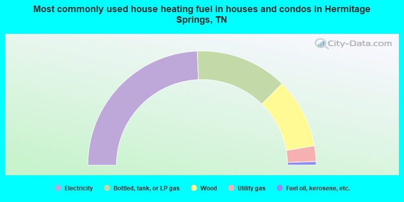
- 48.7%Electricity
- 26.0%Bottled, tank, or LP gas
- 19.9%Wood
- 4.4%Utility gas
- 1.0%Fuel oil, kerosene, etc.
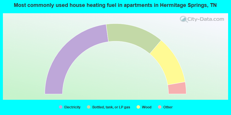
- 45.7%Electricity
- 26.6%Bottled, tank, or LP gas
- 22.1%Wood
- 3.0%Fuel oil, kerosene, etc.
- 2.5%Utility gas
Hermitage Springs compared to Tennessee state average:
- Median house value below state average.
- Unemployed percentage below state average.
- Black race population percentage significantly below state average.
- Hispanic race population percentage below state average.
- Foreign-born population percentage significantly below state average.
- Renting percentage significantly below state average.
- Length of stay since moving in significantly above state average.
- Number of rooms per house significantly below state average.
- House age significantly below state average.
- Number of college students below state average.
- Percentage of population with a bachelor's degree or higher significantly below state average.