Holton, Wisconsin
Submit your own pictures of this town and show them to the world
- OSM Map
- Google Map
- MSN Map
Population change since 2000: -3.7%
 |
| Males: 473 | |
| Females: 400 |
| Median resident age: | 38.1 years |
| Wisconsin median age: | 42.6 years |
Zip codes: 54405.
| Holton: | $55,588 |
| WI: | $70,996 |
Estimated per capita income in 2022: $26,036 (it was $13,884 in 2000)
Holton town income, earnings, and wages data
Estimated median house or condo value in 2022: $166,734 (it was $79,800 in 2000)
| Holton: | $166,734 |
| WI: | $252,800 |
Mean prices in 2022: all housing units: $244,309; detached houses: $248,058; townhouses or other attached units: $250,016; in 2-unit structures: $447,594; in 3-to-4-unit structures: $109,765; in 5-or-more-unit structures: $137,100; mobile homes: $64,848; occupied boats, rvs, vans, etc.: $112,419
Detailed information about poverty and poor residents in Holton, WI


- 84897.1%White alone
- 222.5%Hispanic
- 30.3%American Indian alone

Races in Holton detailed stats: ancestries, foreign born residents, place of birth
 Recent articles from our blog. Our writers, many of them Ph.D. graduates or candidates, create easy-to-read articles on a wide variety of topics.

Ancestries: German (70.5%), Norwegian (6.4%), Polish (4.9%), Irish (4.1%), Czech (3.4%), French (3.2%).
Current Local Time: CST time zone
Land area: 34.3 square miles.
Population density: 25 people per square mile (very low).
17 residents are foreign born
| This town: | 1.9% |
| Wisconsin: | 3.6% |
| Holton town: | 1.2% ($934) |
| Wisconsin: | 2.0% ($2,245) |
Nearest city with pop. 50,000+: Eau Claire, WI  (61.4 miles , pop. 61,704).
Nearest city with pop. 200,000+: Madison, WI (139.1 miles , pop. 208,054).
Nearest city with pop. 1,000,000+: Chicago, IL (253.3 miles , pop. 2,896,016).
Nearest cities:
), ), ), ), ), ), Latitude: 44.99 N, Longitude: 90.26 W
Area code commonly used in this area: 715

| Here: | 2.4% |
| Wisconsin: | 2.7% |

- Agriculture, forestry, fishing & hunting (34.6%)
- Wood products (10.5%)
- Health care (6.8%)
- Food (4.5%)
- Construction (4.3%)
- Accommodation & food services (3.9%)
- Educational services (3.7%)

- Agriculture, forestry, fishing & hunting (42.3%)
- Wood products (12.0%)
- Construction (6.9%)
- Machinery (5.5%)
- Repair & maintenance (5.1%)
- Metal & metal products (4.0%)
- Food (3.6%)

- Agriculture, forestry, fishing & hunting (24.5%)
- Health care (13.7%)
- Wood products (8.5%)
- Accommodation & food services (8.5%)
- Educational services (7.5%)
- Food (5.7%)
- Textile mills & textile products (3.3%)

- Farmers and farm managers (25.3%)
- Agricultural workers, including supervisors (8.2%)
- Other production occupations, including supervisors (7.4%)
- Driver/sales workers and truck drivers (3.9%)
- Electrical equipment mechanics and other installation, maintenance, and repair workers, including supervisors (3.7%)
- Laborers and material movers, hand (2.9%)
- Preschool, kindergarten, elementary, and middle school teachers (2.7%)

- Farmers and farm managers (33.6%)
- Other production occupations, including supervisors (9.1%)
- Agricultural workers, including supervisors (7.7%)
- Electrical equipment mechanics and other installation, maintenance, and repair workers, including supervisors (6.6%)
- Driver/sales workers and truck drivers (6.2%)
- Metal workers and plastic workers (4.7%)
- Carpenters (3.6%)

- Farmers and farm managers (14.6%)
- Agricultural workers, including supervisors (9.0%)
- Preschool, kindergarten, elementary, and middle school teachers (6.1%)
- Other production occupations, including supervisors (5.2%)
- Bookkeeping, accounting, and auditing clerks (4.7%)
- Other office and administrative support workers, including supervisors (4.7%)
- Nursing, psychiatric, and home health aides (4.2%)
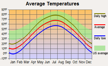
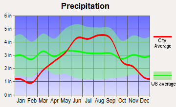
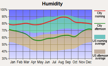
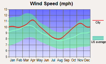
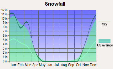
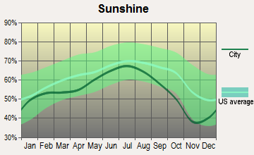
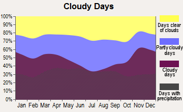
Average climate in Holton, Wisconsin
Based on data reported by over 4,000 weather stations
(lower is better)

Air Quality Index (AQI) level in 2023 was 82.8. This is about average.
| City: | 82.8 |
| U.S.: | 72.6 |

Ozone [ppb] level in 2023 was 39.2. This is about average. Closest monitor was 22.3 miles away from the city center.
| City: | 39.2 |
| U.S.: | 33.3 |

Particulate Matter (PM2.5) [µg/m3] level in 2022 was 6.03. This is better than average. Closest monitor was 22.3 miles away from the city center.
| City: | 6.03 |
| U.S.: | 8.11 |
Tornado activity:
Holton-area historical tornado activity is slightly below Wisconsin state average. It is 0% smaller than the overall U.S. average.
On 6/4/1958, a category F4 (max. wind speeds 207-260 mph) tornado 11.2 miles away from the Holton town center killed 4 people and injured 3 people and caused between $500,000 and $5,000,000 in damages.
On 9/28/1971, a category F3 (max. wind speeds 158-206 mph) tornado 10.0 miles away from the town center injured 5 people and caused between $50,000 and $500,000 in damages.
Earthquake activity:
Holton-area historical earthquake activity is significantly above Wisconsin state average. It is 75% smaller than the overall U.S. average.On 7/9/1975 at 14:54:15, a magnitude 4.6 (4.6 MB, Class: Light, Intensity: IV - V) earthquake occurred 284.8 miles away from Holton center
On 6/28/2004 at 06:10:52, a magnitude 4.2 (4.2 MW, Depth: 6.2 mi) earthquake occurred 253.3 miles away from Holton center
On 2/10/2010 at 09:59:35, a magnitude 3.8 (3.8 MW, Depth: 6.2 mi, Class: Light, Intensity: II - III) earthquake occurred 226.7 miles away from the city center
On 5/2/2015 at 16:23:07, a magnitude 4.2 (4.2 MW, Depth: 2.8 mi) earthquake occurred 307.8 miles away from Holton center
On 6/5/1993 at 01:24:53, a magnitude 4.1 (4.1 LG, Depth: 6.2 mi) earthquake occurred 297.0 miles away from the city center
On 9/2/1999 at 16:17:29, a magnitude 3.5 (3.5 LG, Depth: 3.1 mi) earthquake occurred 229.6 miles away from Holton center
Magnitude types: regional Lg-wave magnitude (LG), body-wave magnitude (MB), moment magnitude (MW)
Natural disasters:
The number of natural disasters in Marathon County (10) is smaller than the US average (15).Major Disasters (Presidential) Declared: 8
Emergencies Declared: 2
Causes of natural disasters: Floods: 7, Storms: 7, Tornadoes: 3, Drought: 1, Hurricane: 1, Other: 1 (Note: some incidents may be assigned to more than one category).
Hospitals and medical centers near Holton:
- GOLDEN LIVINGCENTER-CONTINENTAL MANOR (Nursing Home, about 4 miles away; ABBOTSFORD, WI)
- COLONIAL CENTER (Nursing Home, about 6 miles away; COLBY, WI)
- MEMORIAL HEALTH CENTER DIALYSIS (Dialysis Facility, about 12 miles away; MEDFORD, WI)
- MEMORIAL NURSING AND REHAB CENTER (Nursing Home, about 12 miles away; MEDFORD, WI)
Colleges/universities with over 2000 students nearest to Holton:
- Northcentral Technical College (about 31 miles; Wausau, WI; Full-time enrollment: 3,356)
- University of Wisconsin-Stevens Point (about 47 miles; Stevens Point, WI; FT enrollment: 9,089)
- Mid-State Technical College (about 48 miles; Wisconsin Rapids, WI; FT enrollment: 2,128)
- University of Wisconsin-Eau Claire (about 62 miles; Eau Claire, WI; FT enrollment: 10,143)
- Chippewa Valley Technical College (about 63 miles; Eau Claire, WI; FT enrollment: 4,038)
- University of Wisconsin-Stout (about 82 miles; Menomonie, WI; FT enrollment: 8,120)
- University of Wisconsin-La Crosse (about 94 miles; La Crosse, WI; FT enrollment: 9,837)
Points of interest:
Notable locations in Holton: Ploeckelman Farms (A), Venzke Dairy (B). Display/hide their locations on the map
Cemetery: Holton Cemetery (1). Display/hide its location on the map
Rivers: West Branch Big Eau Pleine River (A), East Branch Big Eau Pleine River (B). Display/hide their locations on the map
| This town: | 2.8 people |
| Wisconsin: | 2.4 people |
| This town: | 77.6% |
| Whole state: | 64.4% |
| This town: | 3.2% |
| Whole state: | 7.3% |
No gay or lesbian households reported
| This town: | 14.9% |
| Whole state: | 8.7% |
| This town: | 6.8% |
| Whole state: | 3.7% |
For population 15 years and over in Holton:

- Never married: 25.6%
- Now married: 66.9%
- Separated: 0.9%
- Widowed: 2.0%
- Divorced: 4.7%
For population 25 years and over in Holton:
- High school or higher: 78.9%
- Bachelor's degree or higher: 8.5%
- Graduate or professional degree: 1.3%
- Unemployed: 3.8%
- Mean travel time to work (commute): 19.5 minutes


| Here: | 10.3 |
| Wisconsin average: | 11.0 |
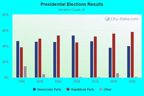
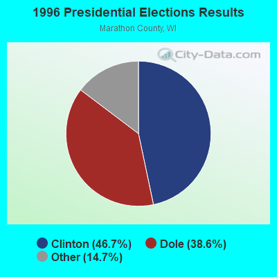
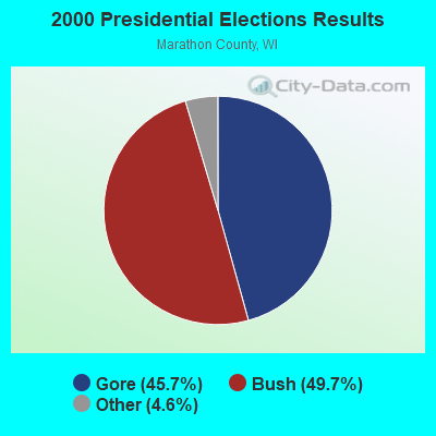
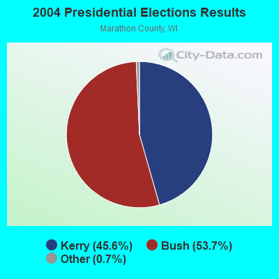
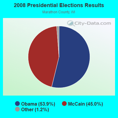
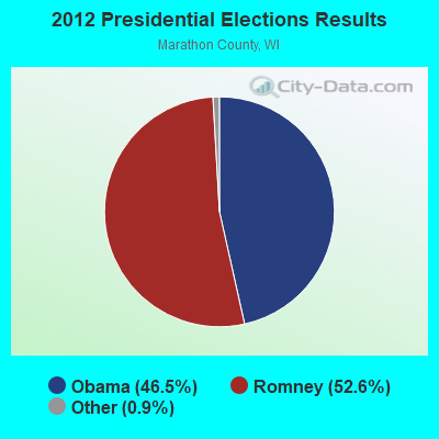
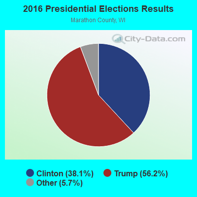
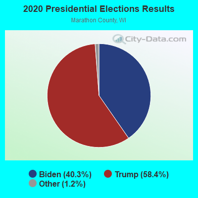
Graphs represent county-level data. Detailed 2008 Election Results
Religion statistics for Holton, WI (based on Marathon County data)
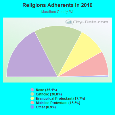
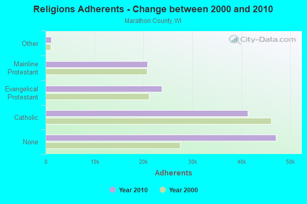
| Religion | Adherents | Congregations |
|---|---|---|
| Catholic | 41,260 | 25 |
| Evangelical Protestant | 23,686 | 75 |
| Mainline Protestant | 20,779 | 39 |
| Other | 1,196 | 9 |
| Orthodox | 40 | 1 |
| None | 47,102 | - |
Food Environment Statistics:
| Marathon County: | 2.47 / 10,000 pop. |
| State: | 1.86 / 10,000 pop. |
| Marathon County: | 0.23 / 10,000 pop. |
| Wisconsin: | 0.11 / 10,000 pop. |
| Here: | 4.16 / 10,000 pop. |
| Wisconsin: | 4.12 / 10,000 pop. |
| This county: | 8.17 / 10,000 pop. |
| State: | 8.64 / 10,000 pop. |
| This county: | 7.9% |
| Wisconsin: | 7.6% |
| Here: | 27.1% |
| State: | 27.5% |
| Marathon County: | 13.2% |
| State: | 13.0% |
Strongest AM radio stations in Holton:
- WSAU (550 AM; 20 kW; WAUSAU, WI; Owner: WRIG, INC.)
- WSPT (1010 AM; 50 kW; STEVENS POINT, WI)
- WRIG (1390 AM; 10 kW; SCHOFIELD, WI; Owner: WRIG, INC.)
- WLBL (930 AM; 5 kW; AUBURNDALE, WI; Owner: STATE OF WISCONSIN - EDUCATIONAL COMMUNICATIONS BOARD)
- WIGM (1490 AM; 1 kW; MEDFORD, WI; Owner: W I G M, INC.)
- WEBC (560 AM; 50 kW; DULUTH, MN)
- WNAM (1280 AM; 50 kW; NEENAH-MENASHA, WI; Owner: CUMULUS LICENSING CORP.)
- WCCN (1370 AM; 5 kW; NEILLSVILLE, WI; Owner: CENTRAL WISCONSIN BROADCASTING, INC.)
- WCTS (1030 AM; 50 kW; MAPLEWOOD, MN; Owner: CNTL. BAPT. THEO/AL SEMI MINNEAPOLIS)
- WCCO (830 AM; 50 kW; MINNEAPOLIS, MN; Owner: INFINITY MEDIA CORPORATION)
- WTMJ (620 AM; 50 kW; MILWAUKEE, WI; Owner: JOURNAL BROADCAST CORPORATION)
- WHBY (1150 AM; 25 kW; KIMBERLY, WI; Owner: WOODWARD COMMUNICATIONS, INC.)
- WFHR (1320 AM; 5 kW; WISCONSIN RAPIDS, WI; Owner: WISCONSIN RAPIDS BROADCASTING, LLC)
Strongest FM radio stations in Holton:
- WOFM (94.7 FM; MOSINEE, WI; Owner: WRIG, INC.)
- WDEZ (101.9 FM; WAUSAU, WI; Owner: W R I G, INC.)
- WHRM (90.9 FM; WAUSAU, WI; Owner: STATE OF WISCONSIN - EDUCATIONAL COMMUNICATIONS BOARD)
- WAXX (104.5 FM; EAU CLAIRE, WI; Owner: MAVERICK MEDIA OF EAU CLAIRE LICENSE LLC)
- WIFC (95.5 FM; WAUSAU, WI; Owner: WRIG, INC.)
- WKEB (99.3 FM; MEDFORD, WI; Owner: WIGM, INCORPORATED)
- WLBL-FM (91.9 FM; WAUSAU, WI; Owner: STATE OF WISCONSIN - EDUCATIONAL COMMUNICATIONS BOARD)
- WXPW (91.9 FM; WAUSAU, WI; Owner: WHITE PINE COMMUNITY BROADCASTING, INC)
- WOSQ (92.3 FM; SPENCER, WI; Owner: NEWRADIO GROUP, LLC)
- WLJY (106.5 FM; MARSHFIELD, WI; Owner: NEWRADIO GROUP, LLC)
- WYCO (107.9 FM; WAUSAU, WI; Owner: SEEHAFER BROADCASTING CORPORATION)
- WMZK (104.1 FM; MERRILL, WI; Owner: ROBERTS BROADCASTING, INC.)
- WWIB (103.7 FM; HALLIE, WI; Owner: STEWARDS OF SOUND, INC.)
- WGNV (88.5 FM; MILLADORE, WI; Owner: EVANGEL MINISTRIES, INC.)
- WCLQ (89.5 FM; WAUSAU, WI; Owner: CHRISTIAN LIFE COMMUNICATIONS, INC.)
- WCCN-FM (107.5 FM; NEILLSVILLE, WI; Owner: CENTRAL WISCONSIN B/CG INC.)
- WKQH (104.9 FM; MARATHON, WI; Owner: RLM COMMUNICATIONS, INC)
TV broadcast stations around Holton:
- WEAU-TV (Channel 13; EAU CLAIRE, WI; Owner: WEAU LICENSEE CORP.)
- WAOW-TV (Channel 9; WAUSAU, WI; Owner: WAOW-WYOW TELEVISION, INC.)
- WSAW-TV (Channel 7; WAUSAU, WI; Owner: GRAY MIDAMERICA TV LICENSEE CORP.)
- W24BV (Channel 24; WHITING, WI; Owner: MS COMMUNICATIONS, LLC)
- WHRM-TV (Channel 20; WAUSAU, WI; Owner: STATE OF WISCONSIN - EDUCATIONAL COMMUNICATIONS BOARD)
- WFXS (Channel 55; WITTENBERG, WI; Owner: DAVIS TELEVISION WAUSAU, LLC)
- National Bridge Inventory (NBI) Statistics
- 22Number of bridges
- 151ft / 46.0mTotal length
- $626,000Total costs
- 43,246Total average daily traffic
- 3,782Total average daily truck traffic
- 64,788Total future (year 2039) average daily traffic

- New bridges - historical statistics
- 11930-1939
- 21940-1949
- 81960-1969
- 31980-1989
- 41990-1999
- 32000-2009
- 12020-2022

- 41.4%Bottled, tank, or LP gas
- 27.6%Fuel oil, kerosene, etc.
- 22.6%Wood
- 7.7%Electricity
- 0.8%Utility gas

- 62.9%Bottled, tank, or LP gas
- 25.7%Fuel oil, kerosene, etc.
- 5.7%Electricity
- 5.7%Wood
Holton compared to Wisconsin state average:
- Median house value below state average.
- Unemployed percentage significantly below state average.
- Black race population percentage significantly below state average.
- Hispanic race population percentage significantly below state average.
- Median age below state average.
- Foreign-born population percentage significantly below state average.
- Renting percentage significantly below state average.
- Length of stay since moving in significantly above state average.
- Number of rooms per house significantly below state average.
- House age significantly below state average.
- Number of college students below state average.
- Percentage of population with a bachelor's degree or higher significantly below state average.
State forum archive: