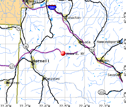
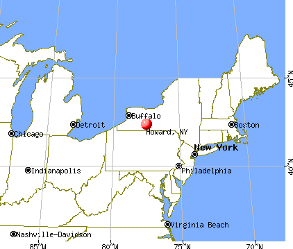
Howard, New York
Submit your own pictures of this town and show them to the world
- OSM Map
- General Map
- Google Map
- MSN Map
Population change since 2000: +2.6%
 |
| Males: 757 | |
| Females: 710 |
| Median resident age: | 42.2 years |
| New York median age: | 40.7 years |
Zip codes: 14843.
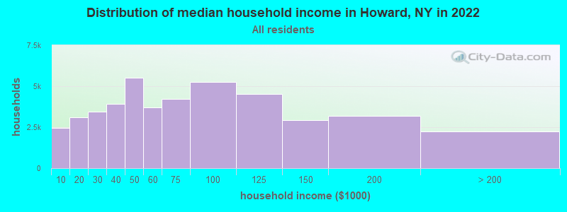
| Howard: | $66,418 |
| NY: | $79,557 |
Estimated per capita income in 2022: $28,771 (it was $15,116 in 2000)
Howard town income, earnings, and wages data
Estimated median house or condo value in 2022: $119,380 (it was $60,700 in 2000)
| Howard: | $119,380 |
| NY: | $400,400 |
Mean prices in 2022: all housing units: $169,714; detached houses: $184,786; townhouses or other attached units: $138,888; in 2-unit structures: $291,252; in 3-to-4-unit structures: $333,918; in 5-or-more-unit structures: $308,305; mobile homes: $80,148; occupied boats, rvs, vans, etc.: $43,655
Detailed information about poverty and poor residents in Howard, NY


- 1,42196.9%White alone
- 261.8%Hispanic
- 110.7%Two or more races
- 30.2%Black alone
- 30.2%American Indian alone
- 30.2%Asian alone
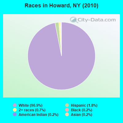
Races in Howard detailed stats: ancestries, foreign born residents, place of birth
According to our research of New York and other state lists, there was 1 registered sex offender living in Howard, New York as of April 18, 2024.
The ratio of all residents to sex offenders in Howard is 1,467 to 1.
The ratio of registered sex offenders to all residents in this city is lower than the state average.
 Recent articles from our blog. Our writers, many of them Ph.D. graduates or candidates, create easy-to-read articles on a wide variety of topics.


Latest news from Howard, NY collected exclusively by city-data.com from local newspapers, TV, and radio stations
Ancestries: English (24.6%), German (23.4%), Irish (18.4%), United States (6.6%), Italian (5.7%), Dutch (5.0%).
Current Local Time: EST time zone
Elevation: 1650 feet
Land area: 60.6 square miles.
Population density: 24 people per square mile (very low).
5 residents are foreign born
| This town: | 0.3% |
| New York: | 20.4% |
| Howard town: | 2.4% ($1,463) |
| New York: | 1.9% ($2,847) |
Nearest city with pop. 50,000+: Rochester, NY  (57.0 miles , pop. 219,773).
Nearest city with pop. 1,000,000+: Philadelphia, PA (203.9 miles , pop. 1,517,550).
Nearest cities:
), ), ), ), ), Latitude: 42.34 N, Longitude: 77.52 W
Area code commonly used in this area: 607

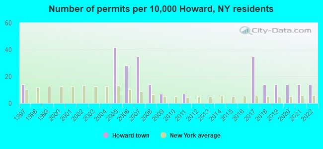
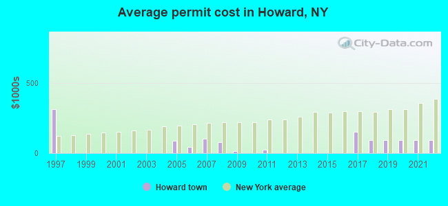
Single-family new house construction building permits:
- 2022: 2 buildings, average cost: $92,500
- 2021: 2 buildings, average cost: $92,500
- 2020: 2 buildings, average cost: $92,500
- 2019: 2 buildings, average cost: $92,500
- 2018: 2 buildings, average cost: $92,500
- 2017: 5 buildings, average cost: $149,400
- 2011: 1 building, cost: $25,000
- 2009: 1 building, cost: $15,000
- 2008: 2 buildings, average cost: $77,500
- 2007: 5 buildings, average cost: $103,800
- 2006: 4 buildings, average cost: $45,000
- 2005: 6 buildings, average cost: $88,700
- 1997: 2 buildings, average cost: $312,500
| Here: | 4.5% |
| New York: | 4.4% |
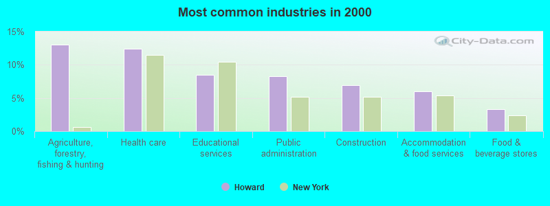
- Agriculture, forestry, fishing & hunting (13.0%)
- Health care (12.4%)
- Educational services (8.5%)
- Public administration (8.2%)
- Construction (6.9%)
- Accommodation & food services (6.0%)
- Food & beverage stores (3.3%)
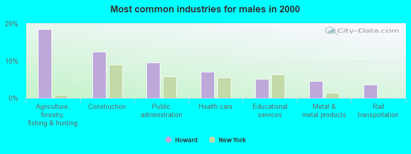
- Agriculture, forestry, fishing & hunting (18.5%)
- Construction (12.4%)
- Public administration (9.6%)
- Health care (7.0%)
- Educational services (5.1%)
- Metal & metal products (4.5%)
- Rail transportation (3.7%)
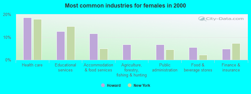
- Health care (18.6%)
- Educational services (12.5%)
- Accommodation & food services (11.5%)
- Agriculture, forestry, fishing & hunting (6.7%)
- Public administration (6.7%)
- Food & beverage stores (5.4%)
- Finance & insurance (4.8%)
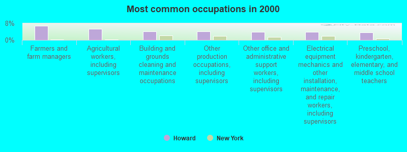
- Farmers and farm managers (6.9%)
- Agricultural workers, including supervisors (5.2%)
- Building and grounds cleaning and maintenance occupations (4.2%)
- Other production occupations, including supervisors (4.0%)
- Other office and administrative support workers, including supervisors (3.9%)
- Electrical equipment mechanics and other installation, maintenance, and repair workers, including supervisors (3.9%)
- Preschool, kindergarten, elementary, and middle school teachers (3.7%)
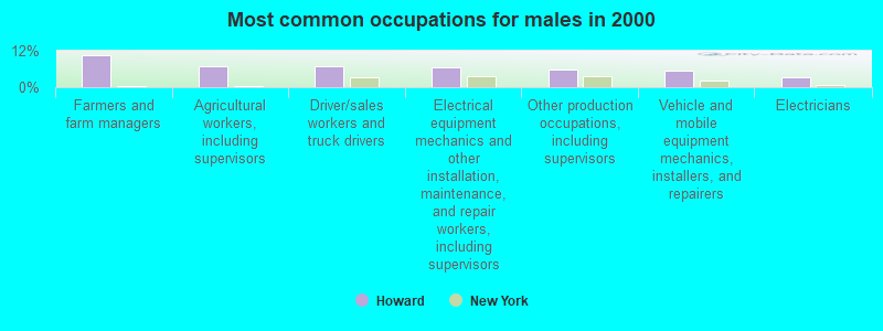
- Farmers and farm managers (10.4%)
- Agricultural workers, including supervisors (7.0%)
- Driver/sales workers and truck drivers (6.7%)
- Electrical equipment mechanics and other installation, maintenance, and repair workers, including supervisors (6.5%)
- Other production occupations, including supervisors (5.9%)
- Vehicle and mobile equipment mechanics, installers, and repairers (5.3%)
- Electricians (3.4%)
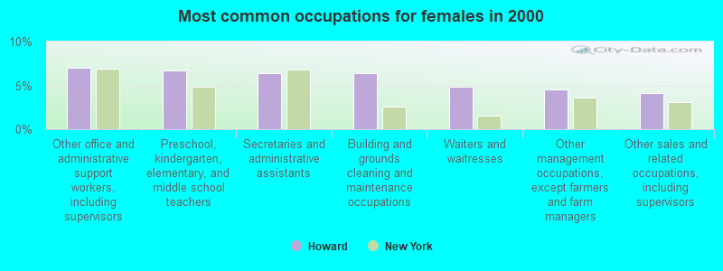
- Other office and administrative support workers, including supervisors (7.1%)
- Preschool, kindergarten, elementary, and middle school teachers (6.7%)
- Secretaries and administrative assistants (6.4%)
- Building and grounds cleaning and maintenance occupations (6.4%)
- Waiters and waitresses (4.8%)
- Other management occupations, except farmers and farm managers (4.5%)
- Other sales and related occupations, including supervisors (4.2%)
Average climate in Howard, New York
Based on data reported by over 4,000 weather stations


(lower is better)
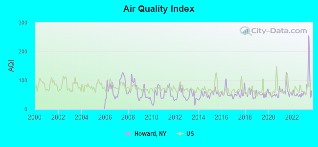
Air Quality Index (AQI) level in 2023 was 91.9. This is worse than average.
| City: | 91.9 |
| U.S.: | 72.6 |
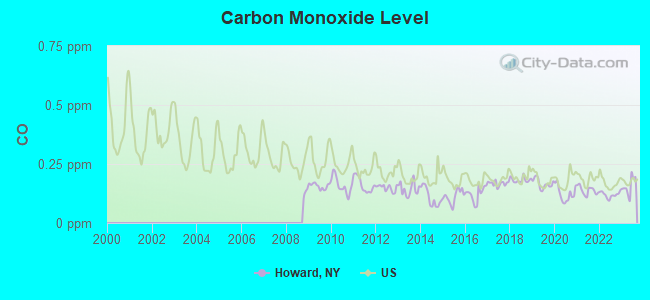
Carbon Monoxide (CO) [ppm] level in 2023 was 0.156. This is significantly better than average. Closest monitor was 23.5 miles away from the city center.
| City: | 0.156 |
| U.S.: | 0.251 |

Nitrogen Dioxide (NO2) [ppb] level in 2011 was 2.25. This is significantly better than average. Closest monitor was 23.5 miles away from the city center.
| City: | 2.25 |
| U.S.: | 5.11 |
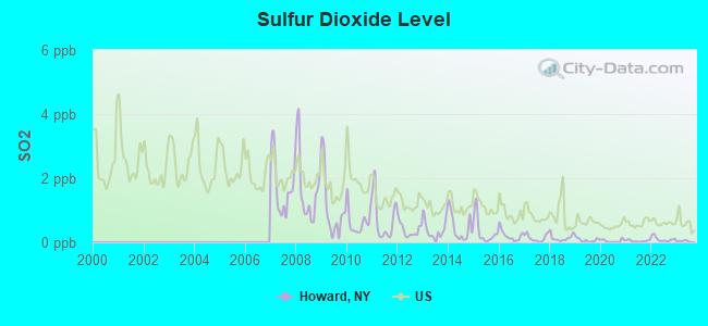
Sulfur Dioxide (SO2) [ppb] level in 2023 was 0.0309. This is significantly better than average. Closest monitor was 15.6 miles away from the city center.
| City: | 0.0309 |
| U.S.: | 1.5147 |
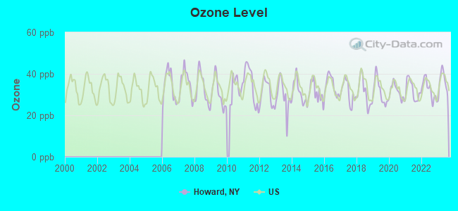
Ozone [ppb] level in 2023 was 35.9. This is about average. Closest monitor was 23.5 miles away from the city center.
| City: | 35.9 |
| U.S.: | 33.3 |
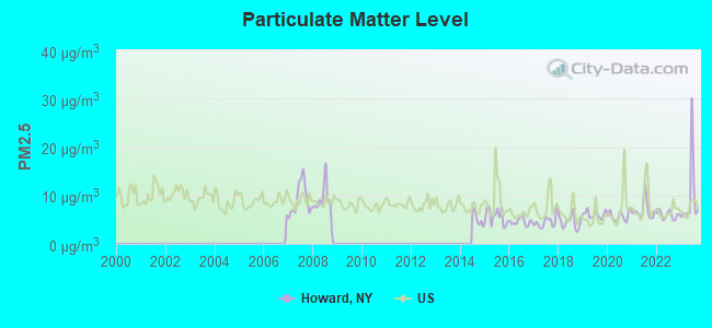
Particulate Matter (PM2.5) [µg/m3] level in 2023 was 9.50. This is about average. Closest monitor was 23.5 miles away from the city center.
| City: | 9.50 |
| U.S.: | 8.11 |
Tornado activity:
Howard-area historical tornado activity is slightly below New York state average. It is 66% smaller than the overall U.S. average.
On 6/20/1969, a category F3 (max. wind speeds 158-206 mph) tornado 27.4 miles away from the Howard town center caused between $500,000 and $5,000,000 in damages.
On 8/30/1955, a category F3 tornado 30.5 miles away from the town center caused between $5000 and $50,000 in damages.
Earthquake activity:
Howard-area historical earthquake activity is significantly above New York state average. It is 66% smaller than the overall U.S. average.On 9/25/1998 at 19:52:52, a magnitude 5.2 (4.8 MB, 4.3 MS, 5.2 LG, 4.5 MW, Depth: 3.1 mi, Class: Moderate, Intensity: VI - VII) earthquake occurred 159.6 miles away from Howard center
On 10/7/1983 at 10:18:46, a magnitude 5.3 (5.1 MB, 5.3 LG, 5.1 ML) earthquake occurred 195.0 miles away from the city center
On 8/23/2011 at 17:51:04, a magnitude 5.8 (5.8 MW, Depth: 3.7 mi) earthquake occurred 307.6 miles away from the city center
On 4/20/2002 at 10:50:47, a magnitude 5.3 (5.3 ML, Depth: 3.0 mi) earthquake occurred 243.4 miles away from Howard center
On 1/31/1986 at 16:46:43, a magnitude 5.0 (5.0 MB) earthquake occurred 194.3 miles away from Howard center
On 4/20/2002 at 10:50:47, a magnitude 5.2 (5.2 MB, 4.2 MS, 5.2 MW, 5.0 MW) earthquake occurred 241.5 miles away from the city center
Magnitude types: regional Lg-wave magnitude (LG), body-wave magnitude (MB), local magnitude (ML), surface-wave magnitude (MS), moment magnitude (MW)
Natural disasters:
The number of natural disasters in Steuben County (20) is greater than the US average (15).Major Disasters (Presidential) Declared: 16
Emergencies Declared: 4
Causes of natural disasters: Storms: 12, Floods: 10, Hurricanes: 2, Tornadoes: 2, Blizzard: 1, Flash Flood: 1, Heavy Rain: 1, Landslide: 1, Power Outage: 1, Tropical Depression: 1, Tropical Storm: 1, Wind: 1, Winter Storm: 1, Other: 1 (Note: some incidents may be assigned to more than one category).

Hospitals and medical centers near Howard:
- HORNELL GARDENS (Nursing Home, about 8 miles away; HORNELL, NY)
- ST JAMES MERCY HOSPITAL Acute Care Hospitals (about 8 miles away; HORNELL, NY)
- ST. JAMES MERCY HOSPITAL (Dialysis Facility, about 8 miles away; HORNELL, NY)
- BATH VA MEDICAL CENTER (Hospital, Acute Care - Veterans Administration, about 9 miles away; BATH, NY)
- STEUBEN CO PUBLIC HLTH CHHA (Home Health Center, about 11 miles away; BATH, NY)
Colleges/universities with over 2000 students nearest to Howard:
- Alfred University (about 16 miles; Alfred, NY; Full-time enrollment: 2,411)
- SUNY College of Technology at Alfred (about 16 miles; Alfred, NY; FT enrollment: 3,483)
- Corning Community College (about 28 miles; Corning, NY; FT enrollment: 3,036)
- SUNY College at Geneseo (about 35 miles; Geneseo, NY; FT enrollment: 5,520)
- Finger Lakes Community College (about 39 miles; Canandaigua, NY; FT enrollment: 4,732)
- Mansfield University of Pennsylvania (about 45 miles; Mansfield, PA; FT enrollment: 2,826)
- Hobart William Smith Colleges (about 45 miles; Geneva, NY; FT enrollment: 2,476)
Public elementary/middle schools in Howard:
- PS 232 LINDENWOOD (Students: 924, Location: 153-23 83RD ST, Grades: KG-8)
- PS 207 ROCKWOOD PARK (Students: 772, Location: 159-15 88TH ST, Grades: PK-8)
- PS 146 HOWARD BEACH (Students: 702, Location: 98-01 159TH AVE, Grades: PK-8)
Private elementary/middle schools in Howard:
- AVE MARIA CATHOLIC ACADEMY (Students: 192, Location: 15820 101ST ST, Grades: PK-8)
- ST HELEN SCHOOL (Students: 182, Location: 8309 157TH AVE, Grades: PK-8)
Points of interest:
Notable locations in Howard: Palmer Farms (A), Howard Public Library (B), Howard Volunteer Fire Department (C). Display/hide their locations on the map
Church in Howard: Buena Vista Wesleyan Church (A). Display/hide its location on the map
Cemeteries: Scherer Cemetery (1), McConnell Cemetery (2), Johnson Cemetery (3), White Cemetery (4), Allen Cemetery (5), Greenville Cemetery (6), Parkhill Cemetery (7). Display/hide their locations on the map
Lakes and swamps: Smith Pond (A), Lake Demons (B), Spaulding Swamp (C). Display/hide their locations on the map
| This town: | 2.6 people |
| New York: | 2.6 people |
| This town: | 73.1% |
| Whole state: | 63.5% |
| This town: | 8.3% |
| Whole state: | 6.8% |
Likely homosexual households (counted as self-reported same-sex unmarried-partner households)
- Lesbian couples: 0.2% of all households
- Gay men: 0.2% of all households
| This town: | 8.4% |
| Whole state: | 14.6% |
| This town: | 3.0% |
| Whole state: | 7.4% |
13 people in other noninstitutional group quarters in 2000
For population 15 years and over in Howard:
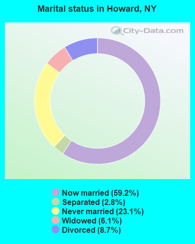
- Never married: 23.1%
- Now married: 59.2%
- Separated: 2.8%
- Widowed: 6.1%
- Divorced: 8.7%
For population 25 years and over in Howard:
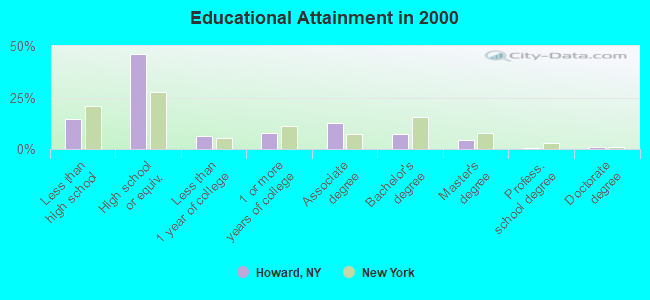
- High school or higher: 85.5%
- Bachelor's degree or higher: 13.1%
- Graduate or professional degree: 5.9%
- Unemployed: 7.1%
- Mean travel time to work (commute): 26.4 minutes
| Here: | 9.0 |
| New York average: | 14.2 |
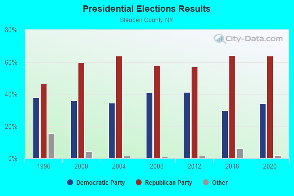
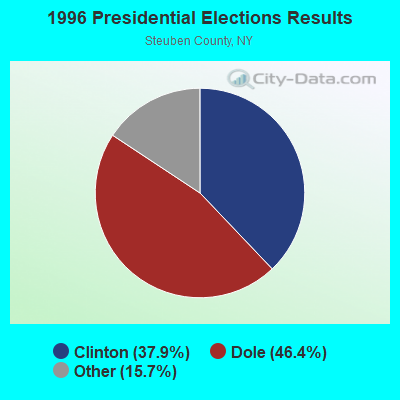
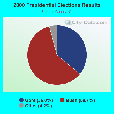
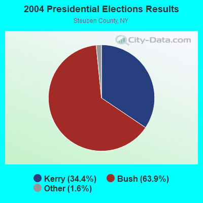
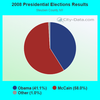
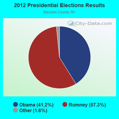
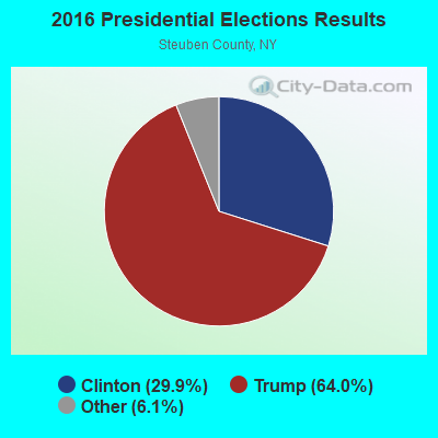
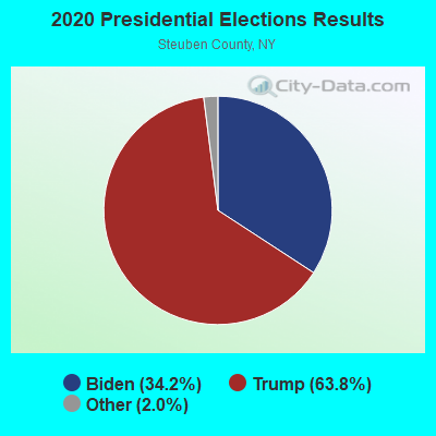
Graphs represent county-level data. Detailed 2008 Election Results
Religion statistics for Howard, NY (based on Steuben County data)
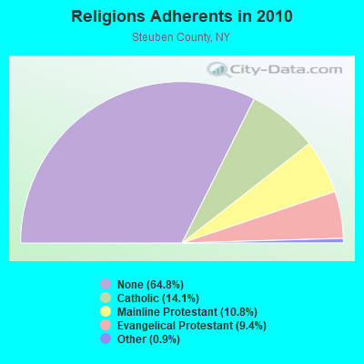
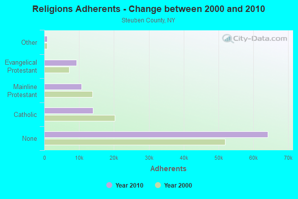
| Religion | Adherents | Congregations |
|---|---|---|
| Catholic | 13,963 | 11 |
| Mainline Protestant | 10,652 | 70 |
| Evangelical Protestant | 9,272 | 72 |
| Other | 857 | 8 |
| Orthodox | 65 | 1 |
| None | 64,181 | - |
Food Environment Statistics:
| Steuben County: | 2.48 / 10,000 pop. |
| State: | 4.13 / 10,000 pop. |
| This county: | 0.10 / 10,000 pop. |
| New York: | 0.06 / 10,000 pop. |
| Here: | 0.72 / 10,000 pop. |
| New York: | 0.92 / 10,000 pop. |
| Here: | 4.24 / 10,000 pop. |
| New York: | 1.68 / 10,000 pop. |
| This county: | 9.00 / 10,000 pop. |
| New York: | 8.82 / 10,000 pop. |
| Steuben County: | 10.2% |
| New York: | 8.2% |
| Steuben County: | 28.3% |
| New York: | 23.8% |
| Here: | 14.2% |
| State: | 15.6% |
Strongest AM radio stations in Howard:
- WABH (1380 AM; 10 kW; BATH, NY)
- WHHO (1320 AM; 5 kW; HORNELL, NY; Owner: BILBAT RADIO, INC.)
- WLEA (1480 AM; 2 kW; HORNELL, NY; Owner: PMJ COMMUNICATIONS, INC.)
- WHAM (1180 AM; 50 kW; ROCHESTER, NY; Owner: CITICASTERS LICENSES, L.P.)
- WWKB (1520 AM; 50 kW; BUFFALO, NY; Owner: ENTERCOM BUFFALO LICENSE, LLC)
- WLNL (1000 AM; daytime; 5 kW; HORSEHEADS, NY; Owner: LIGHTHOUSE MEDIA, INC.)
- WFLR (1570 AM; 5 kW; DUNDEE, NY; Owner: LAKES COUNTY COMMUNICATION CORP.)
- WWLZ (820 AM; 4 kW; HORSEHEADS, NY; Owner: CHEMUNG COUNTY RADIO, INC.)
- WDNY (1400 AM; 1 kW; DANSVILLE, NY; Owner: MILLER MEDIA INC)
- WELM (1410 AM; 5 kW; ELMIRA, NY; Owner: PEMBROOK PINES ELMIRA, LIMITED)
- WPIE (1160 AM; 5 kW; TRUMANSBURG, NY; Owner: PEMBROOK PINES ITHACA LTD. N.A.)
- WWJZ (640 AM; 50 kW; MOUNT HOLLY, NJ; Owner: ABC, INC.)
- WEHH (1590 AM; 5 kW; ELMIRA HTS/HORSEHEAD, NY; Owner: PEMBROOK PINES ELMIRA, LTD.)
Strongest FM radio stations in Howard:
- WCIK (103.1 FM; BATH, NY; Owner: FAMILY LIFE MINISTRIES, INC.)
- WCKR (92.1 FM; HORNELL, NY; Owner: PMJ COMMUNICATIONS, INC.)
- WSQA (88.7 FM; HORNELL, NY; Owner: WSKG PUBLIC TELECOMMUNICATIONS COUNCIL)
- WKPQ (105.3 FM; HORNELL, NY; Owner: BILBAT RADIO, INC.)
- WDNY-FM (93.9 FM; DANSVILLE, NY; Owner: MILLER MEDIA INC.)
- WVIN-FM (98.3 FM; BATH, NY; Owner: PEMBROOK PINES MASS MEDIA, NA CORP.)
- W201CY (88.1 FM; DANSVILLE, NY; Owner: MARS HILL BROADCASTING CO., INC.)
- W257AX (99.3 FM; HORNELL, NY; Owner: FAMILY LIFE MINISTRIES, INC.)
- W246AP (97.1 FM; DANSVILLE, NY; Owner: CALVARY CHAPEL OF THE FINGER LAKES)
- W282AC (104.3 FM; DANSVILLE, NY; Owner: FAMILY LIFE MINISTRIES, INC.)
- WZKZ (101.9 FM; ALFRED, NY; Owner: PEMBROOK PINES ELMIRA, LTD.)
- WCIY (88.9 FM; CANANDAIGUA, NY; Owner: FAMILY LIFE MINISTRIES, INC.)
- WFXF (107.3 FM; SOUTH BRISTOL TOWNSH, NY; Owner: CITICASTERS LICENSES, L.P.)
- WNVE (95.1 FM; HONEOYE FALLS, NY; Owner: CITICASTERS LICENSES, L.P.)
- WGMM (97.7 FM; BIG FLATS, NY; Owner: EOLIN BROADCASTING, INC.)
- WCBA-FM (98.7 FM; CORNING, NY; Owner: EOLIN BROADCASTING, INC.)
- WETD (90.7 FM; ALFRED, NY; Owner: STATE UNIVERSITY OF NEW YORK)
- WMTT (94.7 FM; TIOGA, PA; Owner: EUROPA COMMUNICATIONS, INC.)
- WISY (102.3 FM; CANANDAIGUA, NY; Owner: CITICASTERS LICENSES, L.P.)
- WFLR-FM (95.9 FM; DUNDEE, NY; Owner: LAKES COUNTRY COMMUNICATIONS CORP.)
TV broadcast stations around Howard:
- W16BE (Channel 16; HORNELL, NY; Owner: WYDC, INC.)
- W60AD (Channel 60; SAVONA, NY; Owner: WSKG PUBLIC TELECOMMUNICATIONS COUNCIL)
- WETM-TV (Channel 18; ELMIRA, NY; Owner: SMITH TELEVISION OF NEW YORK LICENSE HOLDINGS, INC.)
- W20BL (Channel 20; BATH, NY; Owner: WYDC, INC.)
- WYDC (Channel 48; CORNING, NY; Owner: WYDC, INC.)
- National Bridge Inventory (NBI) Statistics
- 14Number of bridges
- 85ft / 25.9mTotal length
- $15,048,000Total costs
- 20,591Total average daily traffic
- 501Total average daily truck traffic
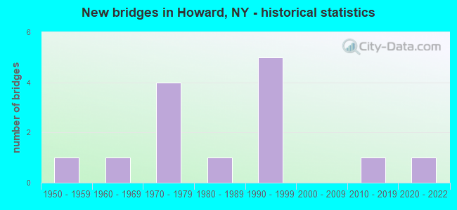
- New bridges - historical statistics
- 11950-1959
- 11960-1969
- 41970-1979
- 11980-1989
- 51990-1999
- 12010-2019
- 12020-2022
FCC Registered Antenna Towers:
15 (See the full list of FCC Registered Antenna Towers in Howard)FCC Registered Microwave Towers:
1- UNY0078, 7069 Hughes Road (Lat: 42.343500 Lon: -77.505333), Type: Ltower, Structure height: 91.4 m, Overall height: 96.6 m, Call Sign: WQSX431,
Assigned Frequencies: 11545.0 MHz, 11585.0 MHz, 11545.0 MHz, 11585.0 MHz, 11545.0 MHz, 11585.0 MHz, 11545.0 MHz, 11585.0 MHz, 11545.0 MHz, 11585.0 MHz... (+10 more), Grant Date: 01/17/2024, Expiration Date: 12/04/2033, Certifier: Karl Kuykendall, Registrant: Uniti Fiber LLC, 107 St. Francis Street, Suite 1800, Mobile, AL 36602, Phone: (877) 652-2321, Email:
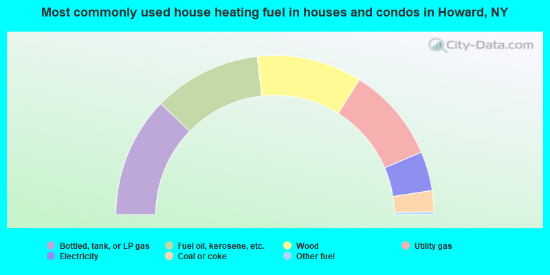
- 24.6%Bottled, tank, or LP gas
- 21.9%Fuel oil, kerosene, etc.
- 21.4%Wood
- 19.4%Utility gas
- 8.0%Electricity
- 4.3%Coal or coke
- 0.5%Other fuel
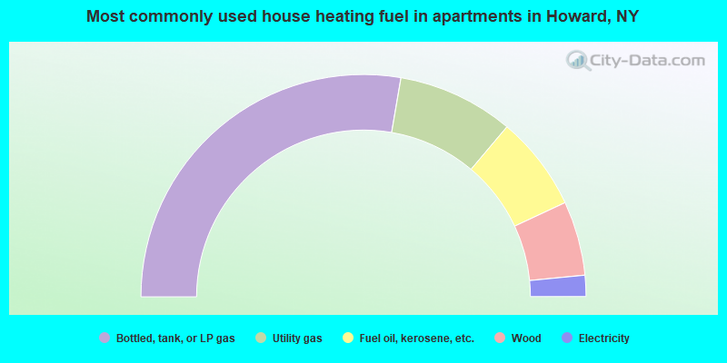
- 55.4%Bottled, tank, or LP gas
- 16.9%Utility gas
- 13.8%Fuel oil, kerosene, etc.
- 10.8%Wood
- 3.1%Electricity
Howard compared to New York state average:
- Median house value significantly below state average.
- Unemployed percentage below state average.
- Black race population percentage significantly below state average.
- Hispanic race population percentage significantly below state average.
- Foreign-born population percentage significantly below state average.
- Renting percentage significantly below state average.
- Length of stay since moving in significantly above state average.
- Number of rooms per house significantly below state average.
- House age significantly below state average.
- Number of college students below state average.
- Percentage of population with a bachelor's degree or higher below state average.