Huerfano Valley, Colorado
Submit your own pictures of this place and show them to the world
- OSM Map
- General Map
- Google Map
- MSN Map

| Males: 574 | |
| Females: 532 |
| Median resident age: | 34.7 years |
| Colorado median age: | 34.3 years |
Zip code: 81022
| Huerfano Valley: | $63,953 |
| CO: | $89,302 |
Estimated per capita income in 2022: $25,055 (it was $13,726 in 2000)
Huerfano Valley CCD income, earnings, and wages data
Estimated median house or condo value in 2022: $341,302 (it was $108,300 in 2000)
| Huerfano Valley: | $341,302 |
| CO: | $531,100 |
Mean prices in 2022: all housing units: $286,422; detached houses: $291,247; townhouses or other attached units: $315,514; in 2-unit structures: $321,637; in 5-or-more-unit structures: $685,963; mobile homes: $106,314
Huerfano Valley, CO residents, houses, and apartments details
Detailed information about poverty and poor residents in Huerfano Valley, CO


- 84983.5%White alone
- 14113.9%Hispanic
- 161.6%Two or more races
- 90.9%American Indian alone
- 10.10%Black alone
- 10.10%Other race alone

 Recent articles from our blog. Our writers, many of them Ph.D. graduates or candidates, create easy-to-read articles on a wide variety of topics.

Current Local Time: MST time zone
Land area: 806.0 square miles.
Population density: 1.4 people per square mile (very low).

| Huerfano Valley CCD: | 0.5% ($565) |
| Colorado: | 0.7% ($1,132) |
Nearest city with pop. 50,000+: Pueblo, CO  (23.7 miles , pop. 102,121).
Nearest city with pop. 200,000+: Colorado Springs, CO (64.0 miles , pop. 360,890).
Nearest city with pop. 1,000,000+: Phoenix, AZ (533.7 miles , pop. 1,321,045).
Nearest cities:
), ), ), ), Latitude: 38.01 N, Longitude: 104.33 W
Area code commonly used in this area: 719


| Here: | 4.5% |
| Colorado: | 3.2% |

- Construction (11.5%)
- Health care (9.9%)
- Agriculture, forestry, fishing & hunting (8.8%)
- Educational services (7.6%)
- Accommodation & food services (7.6%)
- Finance & insurance (5.6%)
- Public administration (5.2%)

- Construction (21.2%)
- Agriculture, forestry, fishing & hunting (11.6%)
- Public administration (9.5%)
- Metal & metal products (7.9%)
- Repair & maintenance (5.8%)
- Administrative & support & waste management services (5.4%)
- Transportation equipment (3.3%)

- Health care (21.6%)
- Accommodation & food services (16.7%)
- Educational services (13.7%)
- Finance & insurance (10.3%)
- Broadcasting & telecommunications (7.4%)
- Agriculture, forestry, fishing & hunting (5.4%)
- Department & other general merchandise stores (5.4%)

- Supervisors and other personal care and service workers, except child care workers (6.5%)
- Metal workers and plastic workers (5.6%)
- Bookkeeping, accounting, and auditing clerks (4.7%)
- Agricultural workers, including supervisors (4.5%)
- Laborers and material movers, hand (4.3%)
- Other office and administrative support workers, including supervisors (4.0%)
- Information and record clerks, except customer service representatives (4.0%)

- Metal workers and plastic workers (10.4%)
- Electricians (6.6%)
- Agricultural workers, including supervisors (6.2%)
- Other material moving workers, except laborers (5.8%)
- Vehicle and mobile equipment mechanics, installers, and repairers (5.8%)
- Other production occupations, including supervisors (5.8%)
- Farmers and farm managers (5.4%)

- Supervisors and other personal care and service workers, except child care workers (14.2%)
- Bookkeeping, accounting, and auditing clerks (10.3%)
- Other office and administrative support workers, including supervisors (8.8%)
- Secretaries and administrative assistants (7.8%)
- Other healthcare support occupations (6.9%)
- Laborers and material movers, hand (6.9%)
- Other sales and related occupations, including supervisors (5.4%)
Average climate in Huerfano Valley, Colorado
Based on data reported by over 4,000 weather stations


Tornado activity:
Huerfano Valley-area historical tornado activity is significantly below Colorado state average. It is 67% smaller than the overall U.S. average.
On 8/21/1984, a category F2 (max. wind speeds 113-157 mph) tornado 22.1 miles away from the Huerfano Valley place center caused between $500 and $5000 in damages.
On 7/10/1978, a category F2 tornado 27.4 miles away from the place center injured 2 people and caused between $5000 and $50,000 in damages.
Earthquake activity:
Huerfano Valley-area historical earthquake activity is significantly above Colorado state average. It is 686% greater than the overall U.S. average.On 8/23/2011 at 05:46:18, a magnitude 5.3 (5.3 MW, Depth: 2.5 mi, Class: Moderate, Intensity: VI - VII) earthquake occurred 68.7 miles away from Huerfano Valley center
On 8/18/1959 at 06:37:13, a magnitude 7.7 (7.7 UK, Class: Major, Intensity: VIII - XII) earthquake occurred 559.6 miles away from Huerfano Valley center, causing $26,000,000 total damage
On 8/10/2005 at 22:08:22, a magnitude 5.0 (5.0 MW, Depth: 3.1 mi) earthquake occurred 78.6 miles away from the city center
On 8/10/2005 at 22:08:22, a magnitude 5.0 (5.0 MB, 4.7 MS, 5.0 MW) earthquake occurred 79.2 miles away from the city center
On 8/22/2011 at 23:30:19, a magnitude 4.7 (4.7 MW, Depth: 3.1 mi, Class: Light, Intensity: IV - V) earthquake occurred 68.8 miles away from the city center
On 9/5/2001 at 10:52:07, a magnitude 4.5 (4.5 MB, Depth: 3.1 mi) earthquake occurred 62.1 miles away from the city center
Magnitude types: body-wave magnitude (MB), surface-wave magnitude (MS), moment magnitude (MW)
Natural disasters:
The number of natural disasters in Pueblo County (14) is near the US average (15).Major Disasters (Presidential) Declared: 6
Emergencies Declared: 6
Causes of natural disasters: Floods: 5, Storms: 5, Landslides: 3, Mudslides: 3, Snows: 3, Fires: 2, Tornadoes: 2, Drought: 1, Flash Flood: 1, Heavy Rain: 1, Hurricane: 1, Snowstorm: 1, Other: 1 (Note: some incidents may be assigned to more than one category).
Colleges/universities with over 2000 students nearest to Huerfano Valley:
- Pueblo Community College (about 25 miles; Pueblo, CO; Full-time enrollment: 5,329)
- Colorado State University-Pueblo (about 25 miles; Pueblo, CO; FT enrollment: 5,993)
- Pikes Peak Community College (about 58 miles; Colorado Springs, CO; FT enrollment: 10,395)
- Colorado College (about 64 miles; Colorado Springs, CO; FT enrollment: 2,199)
- University of Colorado Colorado Springs (about 67 miles; Colorado Springs, CO; FT enrollment: 8,700)
- Colorado Technical University-Online (about 67 miles; Colorado Springs, CO; FT enrollment: 22,771)
- Colorado Technical University-Colorado Springs (about 67 miles; Colorado Springs, CO; FT enrollment: 2,049)
Points of interest:
Notable locations in Huerfano Valley: Butler Ranch (A), Sanford Windmill (B), McElhaney Windmill (C), Jacobs Ranch (D), Black Ranch (E), Mustang Ranch (F), English Camp (G), Carr Windmill (H), Weinegar Windmill (I), East Cox Windmill (J), Gallegos Windmill (K), Hog Ranch (L), Finn Windmill (M), Lower Doyle Windmill (N), Flying A Ranch (O), Bull Pasture Windmill (P), Big Flat Windmill (Q), Upper Doyle Windmill (R), Spurlock Ranch (S), New Windmill (T). Display/hide their locations on the map
Church in Huerfano Valley: San Jose Church (A). Display/hide its location on the map
Cemeteries: Doyle Cemetery (1), San Jose Church Cemetery (2), Finn Cemetery (3). Display/hide their locations on the map
Lakes and reservoirs: Dry Lake (A), Karrick Lake (B), Lodge Lake (C), Hungerford Lake (D), Buffalo Arroyo Reservoir (E), Dotson and Enlargement Reservoir (F), Brown Reservoir (G), Dotson Reservoir (H). Display/hide their locations on the map
Streams, rivers, and creeks: Turkey Creek (A), Chicosa Creek (B), Huerfano River (C), Yellowbank Creek (D), Thomkins Arroyo (E), Fourmile Creek (F), Buffalo Arroyo (G), Twomile Arroyo (H), Goat Butte Creek (I). Display/hide their locations on the map
| This place: | 2.7 people |
| Colorado: | 2.5 people |
| This place: | 75.9% |
| Whole state: | 63.9% |
| This place: | 4.2% |
| Whole state: | 6.5% |
Likely homosexual households (counted as self-reported same-sex unmarried-partner households)
- Lesbian couples: 0.5% of all households
- Gay men: 0.5% of all households
| This place: | 15.0% |
| Whole state: | 9.3% |
| This place: | 1.5% |
| Whole state: | 4.1% |
For population 15 years and over in Huerfano Valley:

- Never married: 20.8%
- Now married: 65.6%
- Separated: 0.0%
- Widowed: 3.2%
- Divorced: 10.5%
For population 25 years and over in Huerfano Valley:
- High school or higher: 87.6%
- Bachelor's degree or higher: 14.7%
- Graduate or professional degree: 5.2%
- Unemployed: 11.4%
- Mean travel time to work (commute): 29.0 minutes


| Here: | 9.8 |
| Colorado average: | 11.8 |
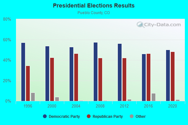
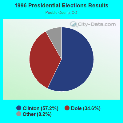
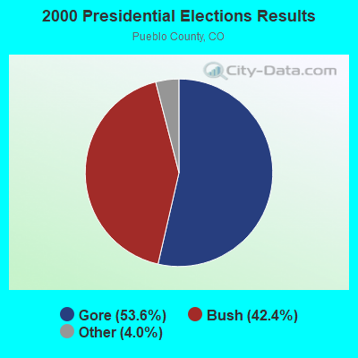
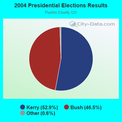

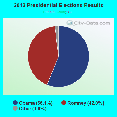
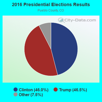
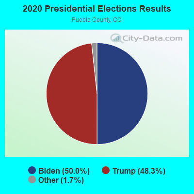
Graphs represent county-level data. Detailed 2008 Election Results
Religion statistics for Huerfano Valley, CO (based on Pueblo County data)
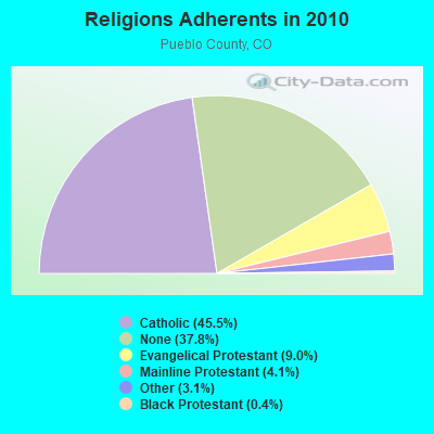
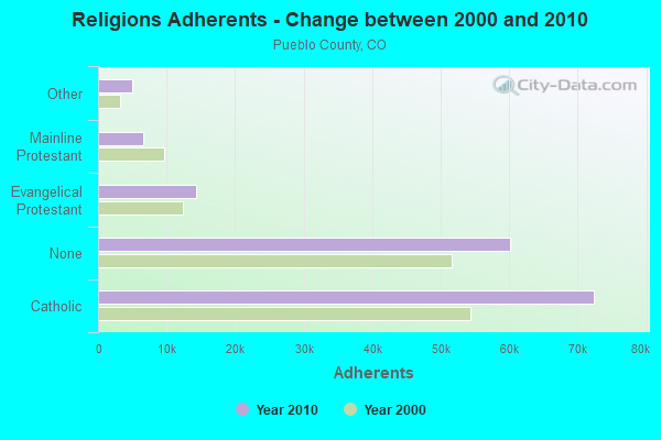
| Religion | Adherents | Congregations |
|---|---|---|
| Catholic | 72,405 | 18 |
| Evangelical Protestant | 14,339 | 88 |
| Mainline Protestant | 6,572 | 26 |
| Other | 4,946 | 20 |
| Black Protestant | 615 | 3 |
| Orthodox | 135 | 2 |
| None | 60,051 | - |
Food Environment Statistics:
| This county: | 1.16 / 10,000 pop. |
| Colorado: | 1.50 / 10,000 pop. |
| Here: | 0.19 / 10,000 pop. |
| Colorado: | 0.15 / 10,000 pop. |
| Pueblo County: | 0.19 / 10,000 pop. |
| Colorado: | 0.45 / 10,000 pop. |
| Pueblo County: | 4.27 / 10,000 pop. |
| Colorado: | 3.13 / 10,000 pop. |
| This county: | 7.69 / 10,000 pop. |
| Colorado: | 8.99 / 10,000 pop. |
| Pueblo County: | 7.0% |
| Colorado: | 5.3% |
| This county: | 23.3% |
| State: | 18.4% |
| Pueblo County: | 10.5% |
| Colorado: | 9.6% |
Strongest AM radio stations in Huerfano Valley:
- KGHF (1350 AM; 5 kW; PUEBLO, CO; Owner: CLEAR CHANNEL BROADCASTING LICENSES, INC.)
- KOA (850 AM; 50 kW; DENVER, CO; Owner: JACOR BROADCASTING OF COLORADO, INC.)
- KFEL (970 AM; 3 kW; PUEBLO, CO; Owner: WELLSPRING HARVEST MINISTRIES, INC.)
- KCBR (1040 AM; daytime; 15 kW; MONUMENT, CO; Owner: KLZ RADIO, INC.)
- KLTT (670 AM; 50 kW; COMMERCE CITY, CO; Owner: KLZ RADIO, INC.)
- KMXA (1090 AM; 50 kW; AURORA, CO; Owner: ENTRAVISION HOLDINGS, LLC)
- KKZN (760 AM; 50 kW; THORNTON, CO; Owner: JACOR BROADCASTING OF COLORADO, INC.)
- KCMN (1530 AM; 15 kW; COLORADO SPRINGS, CO)
- KWYD (1580 AM; 10 kW; COLORADO SPRINGS, CO; Owner: PILGRIM COMMUNICATIONS, INC.)
- KCSJ (590 AM; 1 kW; PUEBLO, CO; Owner: CLEAR CHANNEL BROADCASTING LICENSES, INC.)
- KKOB (770 AM; 50 kW; ALBUQUERQUE, NM; Owner: CITADEL BROADCASTING COMPANY)
- KCUV (1510 AM; 25 kW; LITTLETON, CO; Owner: PEOPLE WIRELESS, INC.)
- KKPC (1230 AM; 1 kW; PUEBLO, CO; Owner: PUBLIC BROADCASTING OF COLORADO, INC.)
Strongest FM radio stations in Huerfano Valley:
- KNKN (107.1 FM; PUEBLO, CO; Owner: METROPOLITAN RADIO GROUP, INC.)
- KKMG (98.9 FM; PUEBLO, CO; Owner: CITADEL BROADCASTING COMPANY)
- KYZX (103.9 FM; PUEBLO WEST, CO; Owner: COLORADO SPRINGS RADIO B/CASTRS, INC)
- KDZA-FM (107.9 FM; PUEBLO, CO; Owner: CAPSTAR TX LIMITED PARTNERSHIP)
- KCCY (96.9 FM; PUEBLO, CO; Owner: CAPSTAR TX LIMITED PARTNERSHIP)
- K203AT (88.5 FM; WESTCLIFFE, ETC., CO; Owner: THE COLORADO COLLEGE)
- KKFM (98.1 FM; COLORADO SPRINGS, CO; Owner: CITADEL BROADCASTING COMPANY)
- KKCS-FM (101.9 FM; COLORADO SPRINGS, CO; Owner: WALTON STATIONS - COLORADO, INC.)
- KBIQ (102.7 FM; MANITOU SPRINGS, CO; Owner: BISON MEDIA, INC.)
- KRCC (91.5 FM; COLORADO SPRINGS, CO; Owner: THE COLORADO COLLEGE)
- KSKX (105.5 FM; SECURITY, CO; Owner: OPTIMA COMMUNICATIONS, INC.)
- KKLI (106.3 FM; WIDEFIELD, CO; Owner: CAPSTAR TX LIMITED PARTNERSHIP)
- KGFT (100.7 FM; PUEBLO, CO; Owner: BISON MEDIA, INC)
- KTLF (90.5 FM; COLORADO SPRINGS, CO; Owner: EDUCATIONAL COMMUNICATIONS OF COLORADO SPRINGS, INC.)
- KSPZ (92.9 FM; COLORADO SPRINGS, CO; Owner: CITADEL BROADCASTING COMPANY)
- KVUU (99.9 FM; PUEBLO, CO; Owner: CAPSTAR TX LIMITED PARTNERSHIP)
- KMOM (96.1 FM; FOUNTAIN, CO; Owner: AMFM TEXAS LICENSES LIMITED PARTNERSHIP)
- KCME (88.7 FM; MANITOU SPRINGS, CO; Owner: CHEYENNE MOUNTAIN PUBLIC BROADCAST HOUSE, INC)
- KILO (94.3 FM; COLORADO SPRINGS, CO; Owner: COLORADO SPRINGS RADIO BCSTERS, INC.)
- KRDO-FM (95.1 FM; COLORADO SPRINGS, CO; Owner: THE PIKES PEAK BROADCASTING CO.)

- 83.2%Bottled, tank, or LP gas
- 9.8%Wood
- 5.3%Electricity
- 1.8%Utility gas

- 90.7%Bottled, tank, or LP gas
- 9.3%Wood
Huerfano Valley compared to Colorado state average:
- Median house value below state average.
- Black race population percentage significantly below state average.
- Foreign-born population percentage significantly below state average.
- Renting percentage below state average.
- Length of stay since moving in significantly above state average.
- Number of rooms per house significantly below state average.
- House age significantly below state average.
- Percentage of population with a bachelor's degree or higher below state average.