Hunt, Idaho
Submit your own pictures of this place and show them to the world
- OSM Map
- General Map
- Google Map
- MSN Map

| Males: 307 | |
| Females: 322 |
| Median resident age: | 26.5 years |
| Idaho median age: | 33.2 years |
Zip code: 83338
| Hunt: | $64,976 |
| ID: | $72,785 |
Estimated per capita income in 2022: $22,422 (it was $11,956 in 2000)
Hunt CCD income, earnings, and wages data
Estimated median house or condo value in 2022: $435,310 (it was $129,200 in 2000)
| Hunt: | $435,310 |
| ID: | $432,500 |
Mean prices in 2022: all housing units: $372,891; detached houses: $402,181; townhouses or other attached units: $203,334; mobile homes: $132,339
Detailed information about poverty and poor residents in Hunt, ID


- 43975.7%White alone
- 13523.3%Hispanic
- 50.9%Two or more races
- 10.2%Asian alone

Races in Hunt detailed stats: ancestries, foreign born residents, place of birth
 Recent articles from our blog. Our writers, many of them Ph.D. graduates or candidates, create easy-to-read articles on a wide variety of topics.

Current Local Time: MST time zone
Elevation: 3955 feet
Land area: 255.3 square miles.
Population density: 2.5 people per square mile (very low).

| Hunt CCD: | 0.8% ($1,089) |
| Idaho: | 1.0% ($1,007) |
Nearest city with pop. 50,000+: Pocatello, ID  (86.2 miles , pop. 51,466).
Nearest city with pop. 200,000+: Las Vegas, NV (453.8 miles , pop. 478,434).
Nearest city with pop. 1,000,000+: Los Angeles, CA (638.5 miles , pop. 3,694,820).
Nearest cities:
Latitude: 42.70 N, Longitude: 114.13 W
Area code commonly used in this area: 208


| Here: | 3.4% |
| Idaho: | 3.1% |

- Agriculture, forestry, fishing & hunting (53.7%)
- Farm supplies merchant wholesalers (5.3%)
- Health care (5.3%)
- Public administration (5.3%)
- Food (4.7%)
- Educational services (3.7%)
- Truck transportation (3.7%)

- Agriculture, forestry, fishing & hunting (73.5%)
- Farm supplies merchant wholesalers (7.6%)
- Food (6.8%)
- Furniture & related product manufacturing (3.8%)
- Broadcasting & telecommunications (3.8%)
- Truck transportation (2.3%)
- Utilities (2.3%)

- Public administration (17.2%)
- Health care (17.2%)
- Educational services (12.1%)
- Finance & insurance (12.1%)
- Agriculture, forestry, fishing & hunting (8.6%)
- Accommodation & food services (8.6%)
- Motor vehicles, parts & supplies merchant wholesalers (8.6%)

- Farmers and farm managers (25.8%)
- Agricultural workers, including supervisors (24.7%)
- Other production occupations, including supervisors (6.8%)
- Laborers and material movers, hand (5.8%)
- Top executives (5.3%)
- Registered nurses (3.7%)
- Life, physical, and social science technicians (3.7%)

- Farmers and farm managers (37.1%)
- Agricultural workers, including supervisors (35.6%)
- Top executives (5.3%)
- Life, physical, and social science technicians (5.3%)
- Laborers and material movers, hand (4.5%)
- Woodworkers (3.8%)
- Electrical equipment mechanics and other installation, maintenance, and repair workers, including supervisors (3.8%)

- Other production occupations, including supervisors (17.2%)
- Preschool, kindergarten, elementary, and middle school teachers (12.1%)
- Other financial specialists (12.1%)
- Registered nurses (12.1%)
- Food and beverage serving workers, except waiters and waitresses (8.6%)
- Secretaries and administrative assistants (8.6%)
- Laborers and material movers, hand (8.6%)
Average climate in Hunt, Idaho
Based on data reported by over 4,000 weather stations


(lower is better)

Air Quality Index (AQI) level in 2022 was 60.3. This is better than average.
| City: | 60.3 |
| U.S.: | 72.6 |

Particulate Matter (PM2.5) [µg/m3] level in 2022 was 6.73. This is better than average. Closest monitor was 6.4 miles away from the city center.
| City: | 6.73 |
| U.S.: | 8.11 |
Earthquake activity:
Hunt-area historical earthquake activity is significantly above Idaho state average. It is 2172% greater than the overall U.S. average.On 10/28/1983 at 14:06:06, a magnitude 7.3 (6.2 MB, 7.3 MS, 7.0 MW, Class: Major, Intensity: VIII - XII) earthquake occurred 96.6 miles away from Hunt center, causing 2 deaths (2 shaking deaths) and 3 injuries, causing $15,000,000 total damage
On 8/18/1959 at 06:37:13, a magnitude 7.7 (7.7 UK) earthquake occurred 216.5 miles away from Hunt center, causing $26,000,000 total damage
On 10/3/1915 at 06:52:48, a magnitude 7.6 (7.6 UK) earthquake occurred 231.4 miles away from the city center
On 3/31/2020 at 23:52:30, a magnitude 6.5 (6.5 MW, Depth: 7.5 mi, Class: Strong, Intensity: VII - IX) earthquake occurred 131.7 miles away from Hunt center
On 3/28/1975 at 02:31:05, a magnitude 6.2 (6.1 MB, 6.0 MS, 6.2 ML) earthquake occurred 97.0 miles away from the city center
On 12/16/1954 at 11:07:12, a magnitude 7.0 (7.0 UK) earthquake occurred 315.4 miles away from Hunt center
Magnitude types: body-wave magnitude (MB), local magnitude (ML), surface-wave magnitude (MS), moment magnitude (MW)
Natural disasters:
The number of natural disasters in Jerome County (5) is a lot smaller than the US average (15).Major Disasters (Presidential) Declared: 2
Emergencies Declared: 1
Causes of natural disasters: Floods: 2, Fire: 1, Heavy Rain: 1, Hurricane: 1, Winter Storm: 1, Other: 1 (Note: some incidents may be assigned to more than one category).
Colleges/universities with over 2000 students nearest to Hunt:
- College of Southern Idaho (about 20 miles; Twin Falls, ID; Full-time enrollment: 5,051)
- Idaho State University (about 88 miles; Pocatello, ID; FT enrollment: 10,350)
- Boise State University (about 123 miles; Boise, ID; FT enrollment: 16,774)
- College of Western Idaho (about 136 miles; Nampa, ID; FT enrollment: 6,300)
- Utah State University (about 136 miles; Logan, UT; FT enrollment: 21,131)
- Northwest Nazarene University (about 137 miles; Nampa, ID; FT enrollment: 2,290)
- Brigham Young University-Idaho (about 142 miles; Rexburg, ID; FT enrollment: 30,522)
Points of interest:
Notable locations in Hunt: Minidoka Relocation Center (A), Midpoint Substation (B). Display/hide their locations on the map
Lakes and reservoirs: Camp Two Lake (A), Rocky Ridge Lake (B), Russian Lake (C), 26 Mile Lake (D), Cheatgrass Reservoir (E), Don Reservoir (F), East Artifact Reservoir (G), Bend Reservoir (H). Display/hide their locations on the map
Park in Hunt: Minidoka Internment National Monument (1). Display/hide its location on the map
| This place: | 3.3 people |
| Idaho: | 2.7 people |
| This place: | 81.8% |
| Whole state: | 69.6% |
| This place: | 6.9% |
| Whole state: | 6.3% |
Likely homosexual households (counted as self-reported same-sex unmarried-partner households)
- Lesbian couples: 0.0% of all households
- Gay men: 1.3% of all households
| This place: | 8.2% |
| Whole state: | 11.8% |
For population 15 years and over in Hunt:

- Never married: 22.3%
- Now married: 70.6%
- Separated: 0.0%
- Widowed: 2.7%
- Divorced: 4.5%
For population 25 years and over in Hunt:
- High school or higher: 81.8%
- Bachelor's degree or higher: 19.8%
- Graduate or professional degree: 0.0%
- Mean travel time to work (commute): 19.4 minutes


| Here: | 10.2 |
| Idaho average: | 11.1 |
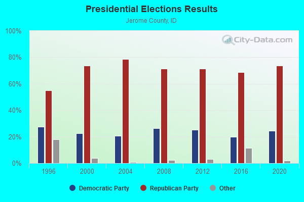
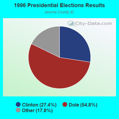
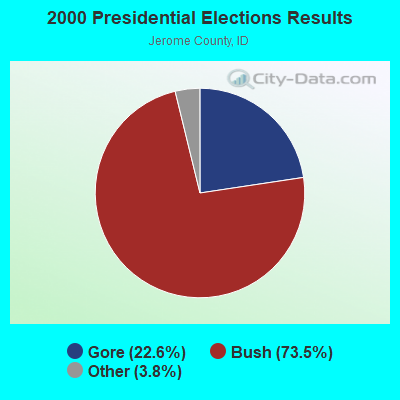
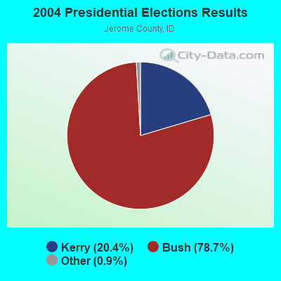
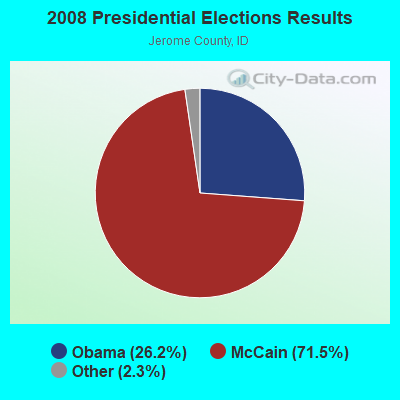
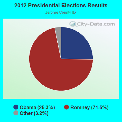
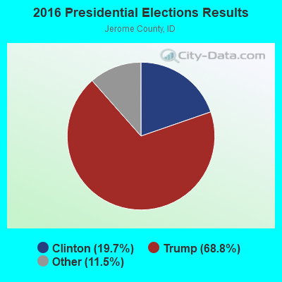
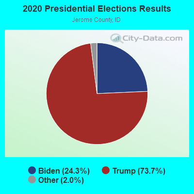
Graphs represent county-level data. Detailed 2008 Election Results
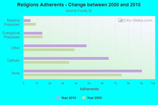
Religion statistics for Hunt, ID (based on Jerome County data)
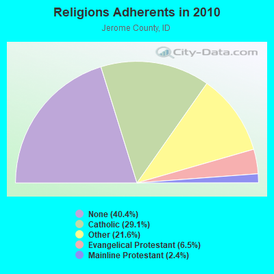
| Religion | Adherents | Congregations |
|---|---|---|
| Catholic | 6,511 | 1 |
| Other | 4,827 | 12 |
| Evangelical Protestant | 1,445 | 15 |
| Mainline Protestant | 547 | 6 |
| None | 9,044 | - |
Food Environment Statistics:
| Jerome County: | 0.50 / 10,000 pop. |
| Idaho: | 1.88 / 10,000 pop. |
| Here: | 0.50 / 10,000 pop. |
| Idaho: | 0.28 / 10,000 pop. |
| Jerome County: | 5.50 / 10,000 pop. |
| State: | 3.87 / 10,000 pop. |
| Jerome County: | 5.50 / 10,000 pop. |
| Idaho: | 7.75 / 10,000 pop. |
| Jerome County: | 7.9% |
| Idaho: | 7.7% |
| This county: | 26.8% |
| Idaho: | 25.7% |
| Here: | 12.4% |
| Idaho: | 11.7% |
Strongest AM radio stations in Hunt:
- KLIX (1310 AM; 5 kW; TWIN FALLS, ID; Owner: CITICASTERS LICENSES, L.P.)
- KTFI (1270 AM; 5 kW; TWIN FALLS, ID; Owner: AGM-IDAHO BROADCASTING, LLC)
- KFTA (970 AM; 2 kW; RUPERT, ID; Owner: TRI-MARKET RADIO BROADCASTERS, INC.)
- KBOI (670 AM; 50 kW; BOISE, ID; Owner: CITADEL BROADCASTING COMPANY)
- KRXR (1480 AM; 5 kW; GOODING, ID; Owner: MARIA ELENA JUAREZ)
- KALL (700 AM; 50 kW; NORTH SALT LAKE CITY, UT; Owner: CITICASTERS LICENSES, L.P.)
- KBAR (1230 AM; 1 kW; BURLEY, ID; Owner: KART & EAGLE ROCK B/C INC,TENANTS)
- KEZJ (1450 AM; 1 kW; TWIN FALLS, ID; Owner: COLLEGE OF SOUTHERN IDAHO)
- KART (1400 AM; 1 kW; JEROME, ID; Owner: KART BROADCASTING CO., INC.)
- KIQN (1010 AM; 50 kW; TOOELE, UT)
- KZNR (690 AM; 10 kW; BLACKFOOT, ID; Owner: WESTERN COMMUNICATIONS, INC.)
- KSL (1160 AM; 50 kW; SALT LAKE CITY, UT; Owner: BONNEVILLE HOLDING COMPANY)
- KWEI (1260 AM; 50 kW; WEISER, ID; Owner: TREASURE VALLEY BROADCASTING CO.)
Strongest FM radio stations in Hunt:
- KEFX (88.9 FM; TWIN FALLS, ID; Owner: CALVARY CHAPEL OF TWIN FALLS, INC.)
- KAWZ (89.9 FM; TWIN FALLS, ID; Owner: CALVARY CHAPEL OF TWIN FALLS)
- KMVX (102.9 FM; JEROME, ID; Owner: KART BROADCASTING CO., INC.)
- KCIR (90.7 FM; TWIN FALLS, ID; Owner: FAITH COMMUNICATIONS CORP)
- KKMV (92.5 FM; RUPERT, ID; Owner: TRI-MARKET RADIO BROADCASTERS, INC.)
- KZDX (99.9 FM; BURLEY, ID; Owner: KART & EAGLE ROCK B/C INC,TENANTS)
- KEZJ-FM (95.7 FM; TWIN FALLS, ID; Owner: CITICASTERS LICENSES, L.P.)
- KISY (100.7 FM; GOODING, ID; Owner: AGM-IDAHO BROADCASTING, LLC)
- KBSY (88.5 FM; BURLEY, ID; Owner: IDAHO STATE BOARD OF EDUCATION)
- KBSW (91.7 FM; TWIN FALLS, ID; Owner: IDAHO STATE BOARD OF EDUCATION)
TV broadcast stations around Hunt:
- KMVT (Channel 11; TWIN FALLS, ID; Owner: CATAMOUNT-IDAHO LICENSE L.L.C.)
- K59BV (Channel 59; LAVA HOT SPRINGS, ID; Owner: STATE BOARD OF EDUCATION (IEPBS))
- KTID-LP (Channel 58; TWIN FALLS, ETC., ID; Owner: E-DA-HOE, INC.)
- KTWT-LP (Channel 43; TWIN FALLS, ID; Owner: E-DA-HOE, INC.)
- KCTF-LP (Channel 45; TWIN FALLS, ID; Owner: CHRISTIAN BROADCASTING OF IDAHO, INC.)
- KBAX-LP (Channel 27; TWIN FALLS, ID; Owner: CHRISTIAN BROADCASTING OF IDAHO, INC.)
- KDID-LP (Channel 55; TWIN FALLS, ID; Owner: TWIN BROADCASTING, INC.)
- K25EV (Channel 25; TWIN FALLS, ID; Owner: TRINITY BROADCASTING NETWORK)
- KTFT-LP (Channel 38; TWIN FALLS, ID; Owner: KING BROADCASTING COMPANY)
- KSAW-LP (Channel 52; TWIN FALLS, ID; Owner: JOURNAL BROADCAST CORPORATION)
- KIPT (Channel 13; TWIN FALLS, ID; Owner: STATE BOARD OF EDUCATION, STATE OF IDAHO)

- 48.0%Electricity
- 21.6%Fuel oil, kerosene, etc.
- 13.7%No fuel used
- 5.9%Bottled, tank, or LP gas
- 5.9%Wood
- 4.9%Coal or coke

- 41.1%Electricity
- 19.6%Bottled, tank, or LP gas
- 19.6%Other fuel
- 16.1%Wood
- 3.6%Fuel oil, kerosene, etc.
Hunt compared to Idaho state average:
- Unemployed percentage significantly below state average.
- Black race population percentage significantly below state average.
- Hispanic race population percentage above state average.
- Median age significantly below state average.
- Foreign-born population percentage significantly below state average.
- Length of stay since moving in significantly above state average.
- Number of rooms per house significantly below state average.
- House age significantly below state average.
- Number of college students significantly below state average.