Huntington, Massachusetts
Submit your own pictures of this town and show them to the world
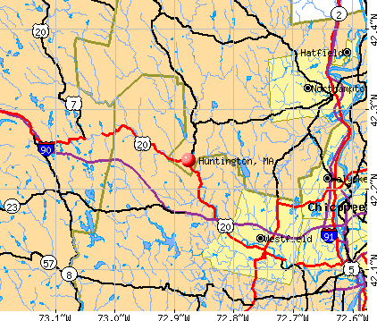
- OSM Map
- General Map
- Google Map
- MSN Map
Population change since 2000: +0.3%
 |
| Males: 1,093 | |
| Females: 1,087 |
| Median resident age: | 42.9 years |
| Massachusetts median age: | 39.2 years |
Zip codes: 01050.
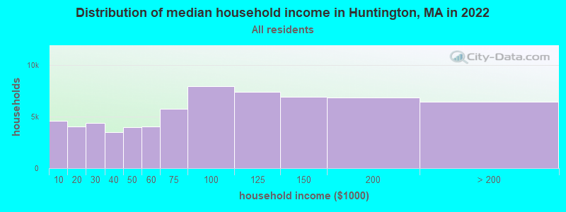
| Huntington: | $87,170 |
| MA: | $94,488 |
Estimated per capita income in 2022: $37,183 (it was $19,385 in 2000)
Huntington town income, earnings, and wages data
Estimated median house or condo value in 2022: $311,605 (it was $119,900 in 2000)
| Huntington: | $311,605 |
| MA: | $534,700 |
Mean prices in 2022: all housing units: $406,762; detached houses: $418,541; townhouses or other attached units: $363,334; in 2-unit structures: $269,911; in 3-to-4-unit structures: $561,325; in 5-or-more-unit structures: $236,751; mobile homes: $362,036
Detailed information about poverty and poor residents in Huntington, MA
Compare current foreclosures near Huntington, MA:
| Photo | Address | Area | Beds / Baths | Price | Details |
|---|---|---|---|---|---|

|
#1
Littleville Rd
Huntington, MA 01050
|
1,188 sq. feet
|
1 baths 2 beds |
show details | |

|
#2
W Franklin St
Holyoke, MA 01040
|
1,558 sq. feet
|
1 baths 2 beds |
$234,900
|
show details |

|
#3
Cold Spring Rd
Southampton, MA 01073
|
2,736 sq. feet
|
1 baths 3 beds |
$284,900
|
show details |

|
#4
Chipman Rd
Middlefield, MA 01243
|
1,486 sq. feet
|
2 baths 2 beds |
show details | |

|
#5
Dewey Cir # 5a
Haydenville, MA 01039
|
800 sq. feet
|
2 baths 3 beds |
show details | |

|
#6
Pleasant St
Holyoke, MA 01040
|
4,057 sq. feet
|
3 baths 6 beds |
show details | |

|
#7
Washington St
Westfield, MA 01085
|
1,300 sq. feet
|
2 baths 3 beds |
show details | |

|
#8
Worthy Ave
West Springfield, MA 01089
|
1,501 sq. feet
|
1 baths 3 beds |
show details | |

|
#9
Lewandowski Ave
Easthampton, MA 01027
|
1,056 sq. feet
|
1 baths 3 beds |
show details | |

|
#10
Montgomery St
Westfield, MA 01085
|
1,714 sq. feet
|
2 baths 4 beds |
show details |
| Photo | Address | Area | Beds / Baths | Price | Details |
|---|---|---|---|---|---|

|
#11
Newbury St
Springfield, MA 01104
|
1,308 sq. feet
|
1 baths 3 beds |
show details | |

|
#12
Ontario St
Springfield, MA 01104
|
1,260 sq. feet
|
1 baths 3 beds |
show details | |

|
#13
Royal St
Chicopee, MA 01020
|
3,296 sq. feet
|
4 baths 7 beds |
show details | |

|
#14
Ontario St
Springfield, MA 01104
|
1,405 sq. feet
|
1 baths 3 beds |
show details | |

|
#15
Catherine St
Chicopee, MA 01013
|
1,073 sq. feet
|
1 baths 2 beds |
show details | |

|
#16
Empire St
Chicopee, MA 01013
|
960 sq. feet
|
1 baths 3 beds |
show details | |

|
#17
Russell Stage Rd
Blandford, MA 01008
|
1,650 sq. feet
|
2 baths 3 beds |
show details | |

|
#18
Lancaster Ave
West Springfield, MA 01089
|
1,505 sq. feet
|
1 baths 3 beds |
show details | |

|
#19
Walter St
Chicopee, MA 01013
|
2,484 sq. feet
|
2 baths 6 beds |
show details | |

|
#20
Telegraph Ave
Chicopee, MA 01020
|
3,072 sq. feet
|
5 baths 6 beds |
show details |
| Photo | Address | Area | Beds / Baths | Price | Details |
|---|---|---|---|---|---|

|
#21
Pondview Dr
Chicopee, MA 01020
|
1,200 sq. feet
|
1 baths 3 beds |
show details | |

|
#22
Birchwood Rd
Southwick, MA 01077
|
1,080 sq. feet
|
1 baths 3 beds |
show details | |

|
#23
Ridgeview Dr
Feeding Hills, MA 01030
|
1,356 sq. feet
|
1 baths 3 beds |
show details | |

|
#24
Westbrook Rd
South Hadley, MA 01075
|
1,048 sq. feet
|
1 baths 3 beds |
show details | |

|
#25
Powder Mill Rd
Southwick, MA 01077
|
1,032 sq. feet
|
1 baths 3 beds |
show details | |

|
#26
Priestly Farms Rd
South Hadley, MA 01075
|
3,004 sq. feet
|
3 baths 3 beds |
show details | |

|
#27
Boulay Cir
Chicopee, MA 01020
|
1,048 sq. feet
|
1 baths 2 beds |
show details | |

|
#28
Clarence St
West Springfield, MA 01089
|
967 sq. feet
|
1 baths 2 beds |
show details | |

|
#29
Morton St
West Springfield, MA 01089
|
907 sq. feet
|
1 baths 2 beds |
show details | |

|
#30
Leo Dr
Chicopee, MA 01020
|
1,228 sq. feet
|
2 baths 3 beds |
show details |
| Photo | Address | Area | Beds / Baths | Price | Details |
|---|---|---|---|---|---|

|
#31
Forest Hill Rd
Feeding Hills, MA 01030
|
1,881 sq. feet
|
1 baths 4 beds |
show details | |

|
#32
Pondview Dr
Chicopee, MA 01020
|
1,410 sq. feet
|
1 baths 3 beds |
show details | |

|
#33
Pine St
South Hadley, MA 01075
|
1,536 sq. feet
|
2 baths 3 beds |
show details | |

|
#34
Brightwood St
Chicopee, MA 01020
|
2,576 sq. feet
|
4 baths 4 beds |
show details | |

|
#35
Beeler Ave
Chicopee, MA 01020
|
1,056 sq. feet
|
1 baths 3 beds |
show details | |

|
#36
Irene St
Chicopee, MA 01020
|
1,088 sq. feet
|
1 baths 3 beds |
show details | |

|
#37
Ohio Ave
Chicopee, MA 01013
|
1,411 sq. feet
|
1 baths 4 beds |
show details | |

|
#38
Penrose Dr
West Springfield, MA 01089
|
1,096 sq. feet
|
1 baths 3 beds |
show details | |

|
#39
David Dr
Hinsdale, MA 01235
|
1,664 sq. feet
|
2 baths 3 beds |
show details | |

|
#40
Calvin St
Chicopee, MA 01013
|
966 sq. feet
|
2 baths 3 beds |
show details |
| Photo | Address | Area | Beds / Baths | Price | Details |
|---|---|---|---|---|---|

|
#41
Brush Hill Ave Apt 56
West Springfield, MA 01089
|
724 sq. feet
|
1 baths 1 beds |
show details | |

|
#42
Chestnut St
West Hatfield, MA 01088
|
1,248 sq. feet
|
1 baths 3 beds |
show details | |

|
#43
Chicopee St # 2
Chicopee, MA 01013
|
2,402 sq. feet
|
2 baths 4 beds |
show details | |

|
#44
Lyman St
South Hadley, MA 01075
|
1,152 sq. feet
|
2 baths 2 beds |
show details | |

|
#45
Mary St
Chicopee, MA 01020
|
1,414 sq. feet
|
2 baths 4 beds |
show details | |

|
#46
Rolf Ave
Chicopee, MA 01020
|
2,354 sq. feet
|
2 baths 4 beds |
show details | |

|
#47
Dale St
Chicopee, MA 01013
|
2,344 sq. feet
|
2 baths 3 beds |
show details | |

|
#48
Bowers St
West Springfield, MA 01089
|
1,080 sq. feet
|
1 baths 3 beds |
show details | |

|
#49
Bridge St # 1
Hatfield, MA 01038
|
3,300 sq. feet
|
3 baths 4 beds |
show details | |

|
Check over 1 million property listings on Foreclosure.com!
|
browse all offers | |||


- 2,09095.9%White alone
- 411.9%Hispanic
- 351.6%Two or more races
- 40.2%Black alone
- 50.2%American Indian alone
- 30.1%Asian alone
- 20.09%Native Hawaiian and Other
Pacific Islander alone
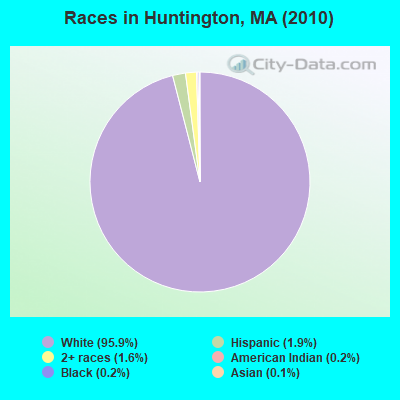
Races in Huntington detailed stats: ancestries, foreign born residents, place of birth
According to our research of Massachusetts and other state lists, there were 3 registered sex offenders living in Huntington, Massachusetts as of April 25, 2024.
The ratio of all residents to sex offenders in Huntington is 727 to 1.
 Recent articles from our blog. Our writers, many of them Ph.D. graduates or candidates, create easy-to-read articles on a wide variety of topics.


 | Like he** I'm going to pay these prices! (684 replies) |
| What is the most iconic building or structure in Boston? (67 replies) |
| Boston Photo Thread (397 replies) |
| Considering going to college in Boston (64 replies) |
| Huntingtom Theater is back! (3 replies) |
| Visiting MA/Boston/Cape Cod (11 replies) |
Latest news from Huntington, MA collected exclusively by city-data.com from local newspapers, TV, and radio stations
Ancestries: English (18.1%), French (17.5%), Irish (17.5%), French Canadian (12.8%), German (9.5%), Polish (9.3%).
Current Local Time: EST time zone
Incorporated in 1775
Elevation: 382 feet
Land area: 26.6 square miles.
Population density: 82 people per square mile (very low).
31 residents are foreign born
| This town: | 1.4% |
| Massachusetts: | 12.2% |
| Huntington town: | 1.3% ($1,618) |
| Massachusetts: | 1.3% ($2,336) |
Nearest city with pop. 50,000+: Chicopee, MA  (15.4 miles , pop. 54,653).
Nearest city with pop. 200,000+: Boston, MA (90.7 miles , pop. 589,141).
Nearest city with pop. 1,000,000+: Bronx, NY (111.2 miles , pop. 1,332,650).
Nearest cities:
), ), ), )Latitude: 42.27 N, Longitude: 72.86 W
Area code: 413
Single-family new house construction building permits:
- 2022: 4 buildings, average cost: $207,700
- 2021: 3 buildings, average cost: $207,700
- 2020: 2 buildings, average cost: $318,700
- 2019: 2 buildings, average cost: $300,000
- 2018: 2 buildings, average cost: $202,800
- 2017: 4 buildings, average cost: $245,600
- 2016: 4 buildings, average cost: $164,600
- 2015: 2 buildings, average cost: $137,500
- 2014: 2 buildings, average cost: $137,500
- 2013: 2 buildings, average cost: $95,000
- 2012: 1 building, cost: $170,000
- 2011: 1 building, cost: $170,000
- 2010: 1 building, cost: $170,000
- 2009: 2 buildings, average cost: $80,000
- 2008: 4 buildings, average cost: $218,500
- 2007: 7 buildings, average cost: $191,400
- 2006: 7 buildings, average cost: $147,800
- 2005: 16 buildings, average cost: $180,400
- 2004: 6 buildings, average cost: $170,300
- 2003: 6 buildings, average cost: $89,200
- 2002: 10 buildings, average cost: $110,100
- 2001: 5 buildings, average cost: $140,400
- 2000: 5 buildings, average cost: $153,100
- 1999: 6 buildings, average cost: $118,000
- 1998: 8 buildings, average cost: $115,500
- 1997: 6 buildings, average cost: $159,200
| Here: | 4.2% |
| Massachusetts: | 3.5% |
- Educational services (14.2%)
- Health care (8.7%)
- Construction (5.9%)
- Accommodation & food services (4.9%)
- Paper (4.7%)
- Metal & metal products (3.8%)
- Professional, scientific, technical services (3.6%)
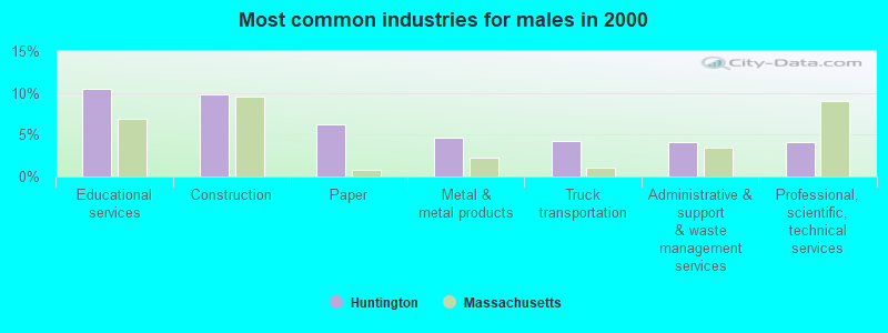
- Educational services (10.5%)
- Construction (9.9%)
- Paper (6.2%)
- Metal & metal products (4.6%)
- Truck transportation (4.3%)
- Administrative & support & waste management services (4.1%)
- Professional, scientific, technical services (4.1%)
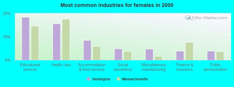
- Educational services (18.4%)
- Health care (15.5%)
- Accommodation & food services (8.5%)
- Social assistance (4.9%)
- Miscellaneous manufacturing (4.7%)
- Finance & insurance (3.8%)
- Public administration (3.8%)
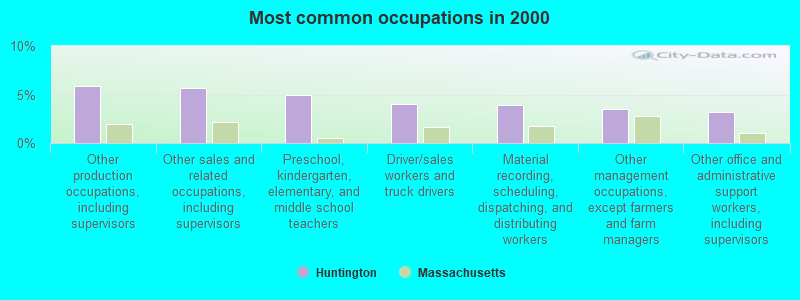
- Other production occupations, including supervisors (5.9%)
- Other sales and related occupations, including supervisors (5.7%)
- Preschool, kindergarten, elementary, and middle school teachers (4.9%)
- Driver/sales workers and truck drivers (4.0%)
- Material recording, scheduling, dispatching, and distributing workers (3.9%)
- Other management occupations, except farmers and farm managers (3.6%)
- Other office and administrative support workers, including supervisors (3.2%)
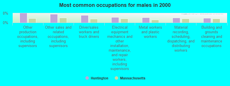
- Other production occupations, including supervisors (8.0%)
- Other sales and related occupations, including supervisors (7.3%)
- Driver/sales workers and truck drivers (6.4%)
- Electrical equipment mechanics and other installation, maintenance, and repair workers, including supervisors (4.6%)
- Metal workers and plastic workers (4.5%)
- Material recording, scheduling, dispatching, and distributing workers (4.1%)
- Building and grounds cleaning and maintenance occupations (4.0%)
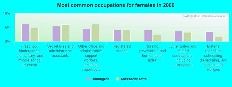
- Preschool, kindergarten, elementary, and middle school teachers (6.3%)
- Secretaries and administrative assistants (5.4%)
- Other office and administrative support workers, including supervisors (4.5%)
- Registered nurses (4.2%)
- Nursing, psychiatric, and home health aides (4.2%)
- Other sales and related occupations, including supervisors (3.8%)
- Material recording, scheduling, dispatching, and distributing workers (3.6%)
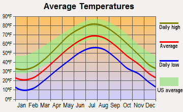
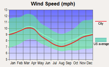
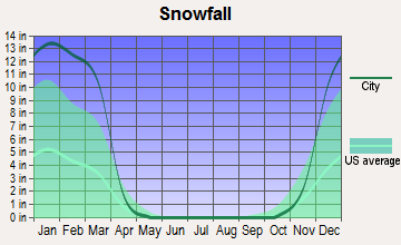
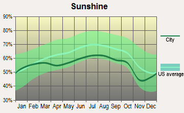
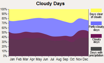
Average climate in Huntington, Massachusetts
Based on data reported by over 4,000 weather stations
(lower is better)
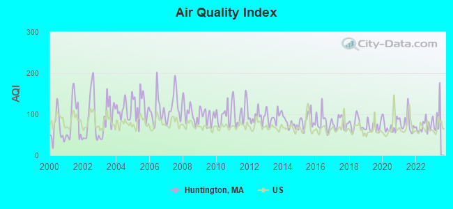
Air Quality Index (AQI) level in 2022 was 69.9. This is about average.
| City: | 69.9 |
| U.S.: | 72.6 |
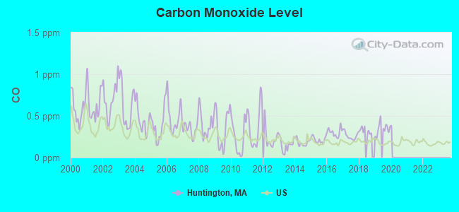
Carbon Monoxide (CO) [ppm] level in 2019 was 0.346. This is worse than average. Closest monitor was 14.2 miles away from the city center.
| City: | 0.346 |
| U.S.: | 0.251 |
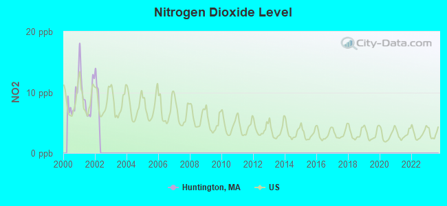
Nitrogen Dioxide (NO2) [ppb] level in 2001 was 9.83. This is significantly worse than average. Closest monitor was 14.1 miles away from the city center.
| City: | 9.83 |
| U.S.: | 5.11 |
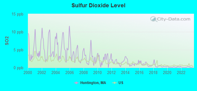
Sulfur Dioxide (SO2) [ppb] level in 2022 was 0.141. This is significantly better than average. Closest monitor was 11.8 miles away from the city center.
| City: | 0.141 |
| U.S.: | 1.515 |
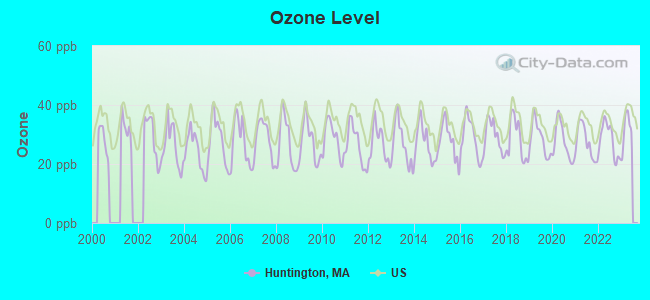
Ozone [ppb] level in 2022 was 28.1. This is about average. Closest monitor was 14.5 miles away from the city center.
| City: | 28.1 |
| U.S.: | 33.3 |
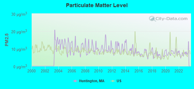
Particulate Matter (PM2.5) [µg/m3] level in 2022 was 6.82. This is about average. Closest monitor was 16.4 miles away from the city center.
| City: | 6.82 |
| U.S.: | 8.11 |
Tornado activity:
Huntington-area historical tornado activity is above Massachusetts state average. It is 10% smaller than the overall U.S. average.
On 10/3/1979, a category F4 (max. wind speeds 207-260 mph) tornado 17.0 miles away from the Huntington town center killed 3 people and injured 500 people and caused between $50,000,000 and $500,000,000 in damages.
On 5/29/1995, a category F4 tornado 17.2 miles away from the town center killed 3 people and injured 24 people and caused between $5,000,000 and $50,000,000 in damages.
Earthquake activity:
Huntington-area historical earthquake activity is significantly above Massachusetts state average. It is 69% smaller than the overall U.S. average.On 10/7/1983 at 10:18:46, a magnitude 5.3 (5.1 MB, 5.3 LG, 5.1 ML, Class: Moderate, Intensity: VI - VII) earthquake occurred 138.6 miles away from the city center
On 4/20/2002 at 10:50:47, a magnitude 5.3 (5.3 ML, Depth: 3.0 mi) earthquake occurred 161.0 miles away from the city center
On 4/20/2002 at 10:50:47, a magnitude 5.2 (5.2 MB, 4.2 MS, 5.2 MW, 5.0 MW) earthquake occurred 159.6 miles away from Huntington center
On 1/19/1982 at 00:14:42, a magnitude 4.7 (4.5 MB, 4.7 MD, 4.5 LG, Class: Light, Intensity: IV - V) earthquake occurred 106.6 miles away from Huntington center
On 10/16/2012 at 23:12:25, a magnitude 4.7 (4.7 ML, Depth: 10.0 mi) earthquake occurred 144.7 miles away from Huntington center
On 8/23/2011 at 17:51:04, a magnitude 5.8 (5.8 MW, Depth: 3.7 mi) earthquake occurred 403.5 miles away from the city center
Magnitude types: regional Lg-wave magnitude (LG), body-wave magnitude (MB), duration magnitude (MD), local magnitude (ML), surface-wave magnitude (MS), moment magnitude (MW)
Natural disasters:
The number of natural disasters in Hampshire County (21) is greater than the US average (15).Major Disasters (Presidential) Declared: 10
Emergencies Declared: 10
Causes of natural disasters: Floods: 5, Snowstorms: 5, Storms: 5, Hurricanes: 4, Winter Storms: 4, Blizzards: 2, Snows: 2, Snowfall: 1, Tropical Storm: 1, Wind: 1, Other: 1 (Note: some incidents may be assigned to more than one category).
Hospitals and medical centers near Huntington:
- NORTHAMPTON VA MEDICAL CENTER (Hospital, Acute Care - Veterans Administration, about 11 miles away; LEEDS, MA)
- OVERLOOK AT NORTHAMPTON (Nursing Home, about 11 miles away; LEEDS, MA)
- LINDA MANOR EXTENDED CARE FACILITY (Nursing Home, about 11 miles away; LEEDS, MA)
- CALVIN COOLIDGE NURING AND REHAB CTR - NORTHAMPTON (Nursing Home, about 12 miles away; NORTHAMPTON, MA)
- COOLEY DICKINSON HOSPITAL INC,THE Acute Care Hospitals (about 12 miles away; NORTHAMPTON, MA)
- NOBLE HOSPITAL Acute Care Hospitals (about 12 miles away; WESTFIELD, MA)
- HOLYOKE REHABILITATION CENTER (Nursing Home, about 12 miles away; HOLYOKE, MA)
Amtrak stations near Huntington:
- 18 miles: SPRINGFIELD (66 LYMAN ST.) . Services: ticket office, partially wheelchair accessible, enclosed waiting area, public restrooms, public payphones, full-service food facilities, snack bar, vending machines, ATM, paid short-term parking, paid long-term parking, call for car rental service, taxi stand, intercity bus service, public transit connection.
- 20 miles: AMHERST (RAILROAD ST.) . Services: enclosed waiting area, public payphones, free short-term parking, paid long-term parking, call for car rental service, call for taxi service, public transit connection.
Colleges/universities with over 2000 students nearest to Huntington:
- Westfield State University (about 10 miles; Westfield, MA; Full-time enrollment: 5,548)
- Holyoke Community College (about 12 miles; Holyoke, MA; FT enrollment: 4,911)
- Smith College (about 12 miles; Northampton, MA; FT enrollment: 3,549)
- Mount Holyoke College (about 15 miles; South Hadley, MA; FT enrollment: 2,573)
- Springfield Technical Community College (about 18 miles; Springfield, MA; FT enrollment: 4,750)
- American International College (about 19 miles; Springfield, MA; FT enrollment: 2,733)
- University of Massachusetts-Amherst (about 20 miles; Amherst, MA; FT enrollment: 26,583)
Public high school in Huntington:
- GATEWAY REGIONAL HIGH (Students: 398, Location: 12 LITTLEVILLE ROAD, Grades: 9-12)
Public elementary/middle schools in Huntington:
- GATEWAY REGIONAL MIDDLE SCHOOL (Students: 440, Location: 12 LITTLEVILLE ROAD, Grades: 5-6)
- LITTLEVILLE ELEMENTARY SCHOOL (Students: 179, Location: 4 LITTLEVILLE ROAD, Grades: PK-4)
- GATEWAY REGIONAL JUNIOR HIGH SCHOOL (Location: 12 LITTLEVILLE ROAD, Grades: 7-8)
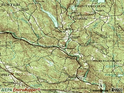
Points of interest:
Notable locations in Huntington: Hilltown Community Ambulance (A), Huntington Fire Department Main Station (B), Gateway Learning Resource Center (C). Display/hide their locations on the map
Churches in Huntington include: Pioneer Valley Assembly Church (A), Huntington Evangelical Church (B). Display/hide their locations on the map
Cemeteries: Saint Thomas Cemetery (1), Norwich Bridge Cemetery (2). Display/hide their locations on the map
Reservoir: Littleville Lake (A). Display/hide its location on the map
Streams, rivers, and creeks: West Branch Westfield River (A), Roaring Brook (B), Cold Brook (C). Display/hide their locations on the map
Birthplace of: Louis B. Allyn - Chemist, Michael J. Dowling (Minnesota politician) - Politician.
Drinking water stations with addresses in Huntington and their reported violations in the past:
HUNTINGTON WATER DEPT (Population served: 1,200, Groundwater):Past health violations:
- MCL, Monthly (TCR) - In NOV-2012, Contaminant: Coliform. Follow-up actions: St AO (w/o penalty) issued (NOV-20-2012)
- MCL, Monthly (TCR) - In MAY-2012, Contaminant: Coliform. Follow-up actions: St AO (w/o penalty) issued (JUN-08-2012)
- MCL, Monthly (TCR) - In SEP-2006, Contaminant: Coliform. Follow-up actions: St AO (w/o penalty) issued (OCT-12-2006)
- MCL, Monthly (TCR) - In OCT-2005, Contaminant: Coliform. Follow-up actions: St AO (w/o penalty) issued (DEC-29-2005)
| This town: | 2.5 people |
| Massachusetts: | 2.5 people |
| This town: | 68.3% |
| Whole state: | 63.0% |
| This town: | 9.2% |
| Whole state: | 7.0% |
Likely homosexual households (counted as self-reported same-sex unmarried-partner households)
- Lesbian couples: 1.4% of all households
- Gay men: 0.7% of all households
| This town: | 5.8% |
| Whole state: | 9.3% |
| This town: | 1.6% |
| Whole state: | 4.4% |
Banks with branches in Huntington (2011 data):
- United Bank: Huntington Branch at 14 Russell Road, branch established on 1996/09/09. Info updated 2012/01/20: Bank assets: $1,617.9 mil, Deposits: $1,235.2 mil, headquarters in West Springfield, MA, positive income, Commercial Lending Specialization, 25 total offices
For population 15 years and over in Huntington:
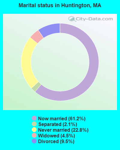
- Never married: 22.8%
- Now married: 61.2%
- Separated: 2.1%
- Widowed: 4.5%
- Divorced: 9.5%
For population 25 years and over in Huntington:
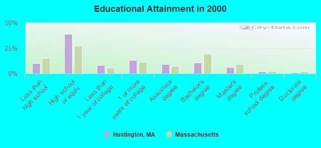
- High school or higher: 89.7%
- Bachelor's degree or higher: 20.2%
- Graduate or professional degree: 9.5%
- Unemployed: 3.7%
- Mean travel time to work (commute): 34.4 minutes
| Here: | 10.1 |
| Massachusetts average: | 13.1 |
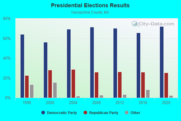
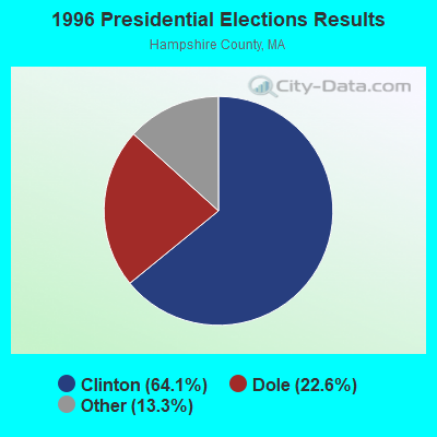
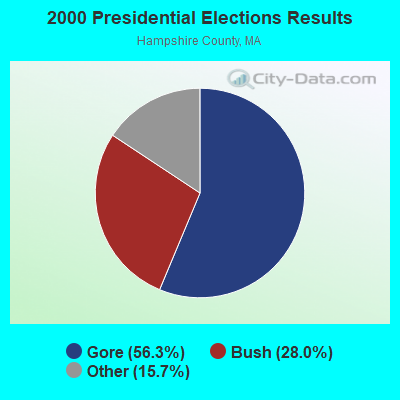
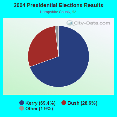
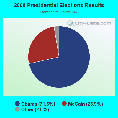
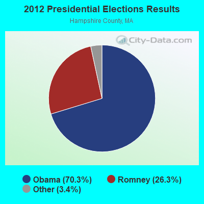
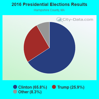
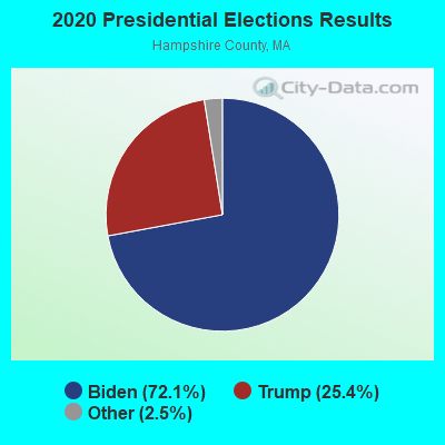
Graphs represent county-level data. Detailed 2008 Election Results
Religion statistics for Huntington, MA (based on Hampshire County data)
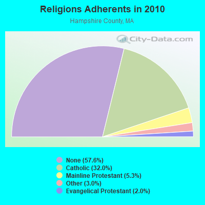
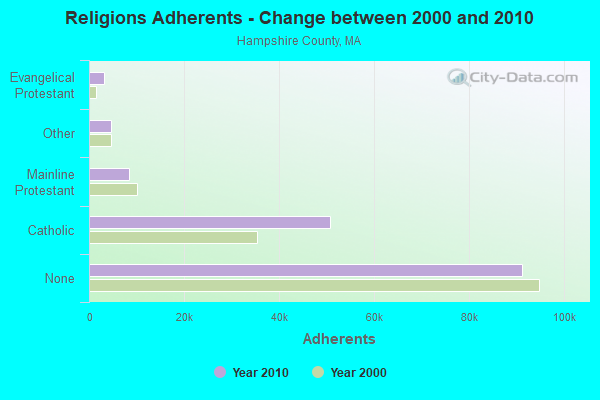
| Religion | Adherents | Congregations |
|---|---|---|
| Catholic | 50,643 | 22 |
| Mainline Protestant | 8,454 | 45 |
| Other | 4,722 | 27 |
| Evangelical Protestant | 3,128 | 22 |
| Black Protestant | 29 | 1 |
| None | 91,104 | - |
Food Environment Statistics:
| Hampshire County: | 2.07 / 10,000 pop. |
| State: | 1.98 / 10,000 pop. |
| This county: | 0.06 / 10,000 pop. |
| Massachusetts: | 0.05 / 10,000 pop. |
| Here: | 1.55 / 10,000 pop. |
| State: | 2.22 / 10,000 pop. |
| Here: | 1.94 / 10,000 pop. |
| Massachusetts: | 1.77 / 10,000 pop. |
| Here: | 10.22 / 10,000 pop. |
| Massachusetts: | 8.76 / 10,000 pop. |
| Hampshire County: | 7.3% |
| State: | 8.1% |
| Here: | 21.7% |
| State: | 22.5% |
| Here: | 12.3% |
| State: | 16.5% |
Strongest AM radio stations in Huntington:
- WNNZ (640 AM; 50 kW; WESTFIELD, MA; Owner: CLEAR CHANNEL BROADCASTING LICENSES, INC.)
- WHYN (560 AM; 5 kW; SPRINGFIELD, MA; Owner: CLEAR CHANNEL BROADCASTING LICENSES, INC.)
- WTIC (1080 AM; 50 kW; HARTFORD, CT; Owner: INFINITY RADIO OPERATIONS INC.)
- WACE (730 AM; 5 kW; CHICOPEE, MA; Owner: CARTER BROADCASTING CORP.)
- WCRN (830 AM; 50 kW; WORCESTER, MA; Owner: CARTER BROADCASTING CORPORATION)
- WVNE (760 AM; daytime; 25 kW; LEICESTER, MA; Owner: BLOUNT MASSCOM, INC.)
- WSPR (1270 AM; 5 kW; SPRINGFIELD, MA; Owner: ANTONIO F. AND HELENA R. GOIS, TENANTS BY THE ENTIRETY)
- WGY (810 AM; 50 kW; SCHENECTADY, NY; Owner: CLEAR CHANNEL BROADCASTING LICENSES, INC.)
- WALE (990 AM; 50 kW; GREENVILLE, RI; Owner: NORTH AMERICAN BROADCASTING CO., INC.)
- WRKO (680 AM; 50 kW; BOSTON, MA; Owner: ENTERCOM BOSTON LICENSE, LLC)
- WIZZ (1520 AM; daytime; 10 kW; GREENFIELD, MA; Owner: P. & M. RADIO, LLC)
- WPTR (1540 AM; 50 kW; ALBANY, NY; Owner: KIMTRON, INC.)
- WPNI (1430 AM; 5 kW; AMHERST, MA; Owner: WESTERN MASSACHUSETTS RADIO COMPANY)
Strongest FM radio stations in Huntington:
- WHYN-FM (93.1 FM; SPRINGFIELD, MA; Owner: CLEAR CHANNEL BROADCASTING LICENSES, INC.)
- WRNX (100.9 FM; AMHERST, MA; Owner: WESTERN MASSACHUSETTS RADIO COMPANY)
- WAQY (102.1 FM; SPRINGFIELD, MA; Owner: SAGA COMMUNICATIONS OF NEW ENGLAND, LLC)
- WAMC-FM (90.3 FM; ALBANY, NY; Owner: WAMC)
- WFCR (88.5 FM; AMHERST, MA; Owner: UNIVERSITY OF MASSACHUSETTS)
- WLZX (99.3 FM; NORTHAMPTON, MA; Owner: SAGA COMMUNICATIONS OF NEW ENGLAND, LLC)
- WPKX (97.9 FM; ENFIELD, CT; Owner: CAPSTAR TX LIMITED PARTNERSHIP)
- WAMH (89.3 FM; AMHERST, MA; Owner: TRUSTEES OF AMHERST COLLEGE)
- WEIB (106.3 FM; NORTHAMPTON, MA; Owner: CUTTING EDGE BROADCASTING, INC.)
- WHVP (91.1 FM; HUDSON, NY; Owner: SOUND OF LIFE, INC.)
- W246AM (97.1 FM; AMHERST, MA; Owner: GREAT NORTHERN RADIO, LLC)
- WEQX (102.7 FM; MANCHESTER, VT; Owner: NORTHSHIRE COMMUNICATIONS, INC.)
- WRCH (100.5 FM; NEW BRITAIN, CT; Owner: INFINITY RADIO OPERATIONS INC.)
- WJAN (95.1 FM; SUNDERLAND, VT; Owner: 6 JOHNSON ROAD LICENSES, INC.)
- WCCH (103.5 FM; HOLYOKE, MA; Owner: HOLYOKE COMMUNITY COLLEGE)
- WAMQ (105.1 FM; GREAT BARRINGTON, MA; Owner: WAMC)
- WBEC-FM (105.5 FM; PITTSFIELD, MA; Owner: GREAT NORTHERN RADIO, LLC)
- WVAY (100.7 FM; WILMINGTON, VT; Owner: GREAT NORTHERN RADIO, L.L.C.)
- WUPE (95.9 FM; PITTSFIELD, MA; Owner: WEINER BROADCASTING, INC.)
- WPVQ (95.3 FM; GREENFIELD, MA; Owner: GREAT NORTHERN RADIO, L.L.C.)
TV broadcast stations around Huntington:
- WWLP (Channel 22; SPRINGFIELD, MA; Owner: WWLP BROADCASTING, LLC)
- WTIC-TV (Channel 61; HARTFORD, CT; Owner: TRIBUNE TELEVISION COMPANY)
- W11BJ (Channel 11; HARTFORD, CT; Owner: COMMUNICATIONS SITE MANAGEMENT LLC)
- W67DF (Channel 67; SPRINGFIELD, MA; Owner: TRINITY BROADCASTING NETWORK)
- WYDN (Channel 48; WORCESTER, MA; Owner: EDUCATIONAL PUBLIC TV CORPORATION)
- WUVN (Channel 18; HARTFORD, CT; Owner: ENTRAVISION HOLDINGS, LLC)
- WTXX (Channel 20; WATERBURY, CT; Owner: WTXX INC.)
- WVIT (Channel 30; NEW BRITAIN, CT; Owner: OUTLET BROADCASTING, INC)
- WEDH (Channel 24; HARTFORD, CT; Owner: CONNECTICUT PUBLIC BROADCASTING, INC.)
- WGGB-TV (Channel 40; SPRINGFIELD, MA; Owner: WGGB LICENSEE, LLC)
- WGBY-TV (Channel 57; SPRINGFIELD, MA; Owner: WGBH EDUCATIONAL FOUNDATION)
- WDMR-LP (Channel 65; SPRINGFIELD, MA; Owner: ZGS HARTFORD, INC.)
- W35BK (Channel 35; PLAINFIELD, MA; Owner: LYDIA SYLVANE STOCKWELL)
- National Bridge Inventory (NBI) Statistics
- 8Number of bridges
- 148ft / 45.0mTotal length
- $37,571,000Total costs
- 22,413Total average daily traffic
- 1,471Total average daily truck traffic
- 27,228Total future (year 2031) average daily traffic
FCC Registered Antenna Towers:
6- Tim McDougall, Pleasant St ( 015667 ) (Lat: 42.240389 Lon: -72.874472), Type: 60.6, Overall height: 57.9 m, Registrant: American Towers, Inc., Bosto-n, Phone: (617) 585-7600
- CARLO CENTORE, 7 Lyman Road (Lat: 42.284639 Lon: -72.858750), Type: 54.8, Overall height: 54.8 m, Phone: (203) 483-9656
- CARLOS CENTORE, 7 Lyman Road (Lat: 42.284639 Lon: -72.858750), Type: 54.8, Overall height: 54.8 m, Phone: (203) 483-9656
- Janis E Merritts, 7 Lyman Road (Lat: 42.284639 Lon: -72.858750), Type: 54.8, Overall height: 54.8 m, Registrant: Pinnacle Towers Acquisition LLC, Regulatory.Department@crowncastle.Com, , Canon-sburg, Phone: (724) 416-2000
- Tim McDougall, Pleasant St ( 015667 ) (Lat: 42.240389 Lon: -72.874472), Type: 60.6, Overall height: 57.9 m, Registrant: American Towers, Inc., Bosto-n, Phone: (617) 585-7600
- Christine A Verre, 7 Lyman Road (Lat: 42.284639 Lon: -72.858750), Type: 54.8, Overall height: 54.8 m, Registrant: Crown Castle Usa, Christine.Verre@crowncastle.Com, , Canon-sburg, Phone: (336) 643-2524
FCC Registered Broadcast Land Mobile Towers:
3- Lat: 42.250361 Lon: -72.870472, Call Sign: WQJA800,
Assigned Frequencies: 452.287 MHz, Grant Date: 07/09/2008, Expiration Date: 07/09/2018, Cancellation Date: 09/08/2018, Certifier: David Hopson, Registrant: Tower Communications Co., 904 Meadow Street, Chicopee, MA 01013, Phone: (413) 592-4554, Fax: (413) 592-3158, Email:
- Lat: 42.251028 Lon: -72.870556, Call Sign: WROS705,
Assigned Frequencies: 451.462 MHz, 451.712 MHz, Grant Date: 12/02/2021, Expiration Date: 12/02/2031, Certifier: Kurt Zinnack, Registrant: Three-Way Communications, 1000 Old County Circle, Unit 114, Windsor Locks, CT 06096, Phone: (860) 627-0571, Email:
- 12 Littleville Road (Lat: 42.251111 Lon: -72.870000), Type: Building, Structure height: 9 m, Call Sign: WSAU885,
Assigned Frequencies: 462.825 MHz, Grant Date: 02/15/2024, Expiration Date: 02/15/2034, Certifier: Chris Parker, Registrant: Visiplex, 1287 Barclay Boulevard, Buffalo Grove, IL 60089, Phone: (847) 229-0250, Email:
FCC Registered Amateur Radio Licenses:
16 (See the full list of FCC Registered Amateur Radio Licenses in Huntington)FAA Registered Aircraft:
2- Aircraft: PIPER PA-28-140 (Category: Land, Seats: 4, Weight: Up to 12,499 Pounds, Speed: 107 mph), Engine: LYCOMING 0-320 SERIES (180 HP) (Reciprocating)
N-Number: 3975K, N3975K, N-3975K, Serial Number: 28-23861, Year manufactured: 1967, Airworthiness Date: 10/19/1967, Certificate Issue Date: 09/10/2015
Registrant (Individual): Mark Iwanicki, 187 Goss Hill Rd, Huntington, MA 01050 - Aircraft: PIPER PA-28R-201 (Category: Land, Seats: 4, Weight: Up to 12,499 Pounds, Speed: 108 mph), Engine: LYCOMING I0360 SER (180 HP) (Reciprocating)
N-Number: 743ED, N743ED, N-743ED, Serial Number: 28R-7837096, Year manufactured: 1977, Airworthiness Date: 12/15/1977, Certificate Issue Date: 10/09/1985
Registrant (Individual): Edward W Grabowski, Goss Hill Rd, Huntington, MA 01050
2002 - 2018 National Fire Incident Reporting System (NFIRS) incidents
- Fire incident types reported to NFIRS in Huntington, MA
- 12342.7%Structure Fires
- 12041.7%Outside Fires
- 258.7%Mobile Property/Vehicle Fires
- 206.9%Other
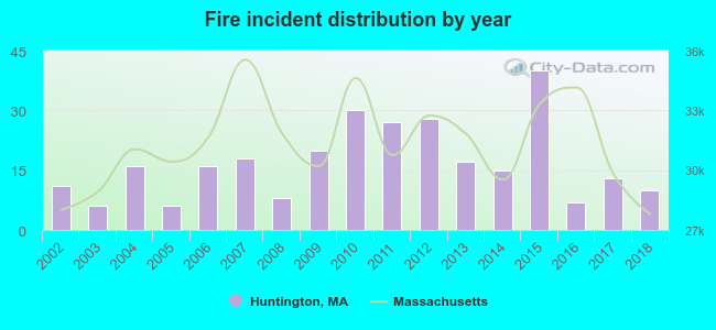 According to the data from the years 2002 - 2018 the average number of fire incidents per year is 17. The highest number of fire incidents - 40 took place in 2015, and the least - 6 in 2003. The data has a declining trend.
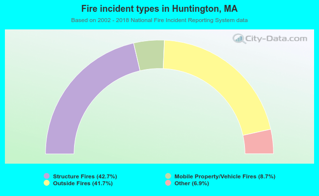 When looking into fire subcategories, the most incidents belonged to: Structure Fires (42.7%), and Outside Fires (41.7%).
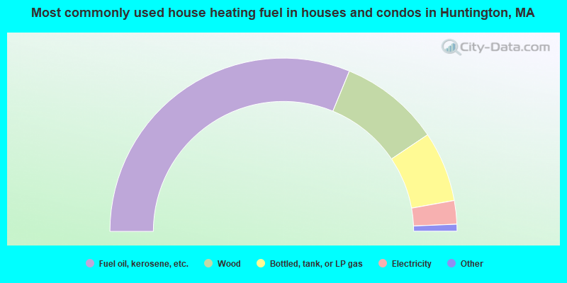
- 62.4%Fuel oil, kerosene, etc.
- 18.8%Wood
- 13.1%Bottled, tank, or LP gas
- 4.4%Electricity
- 0.6%Utility gas
- 0.3%Coal or coke
- 0.3%Other fuel
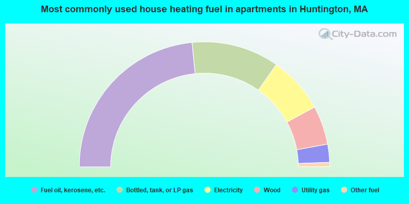
- 46.8%Fuel oil, kerosene, etc.
- 22.6%Bottled, tank, or LP gas
- 14.7%Electricity
- 10.0%Wood
- 4.7%Utility gas
- 1.1%Other fuel
Huntington compared to Massachusetts state average:
- Median house value below state average.
- Unemployed percentage significantly below state average.
- Black race population percentage significantly below state average.
- Hispanic race population percentage significantly below state average.
- Foreign-born population percentage significantly below state average.
- Renting percentage below state average.
- Length of stay since moving in significantly above state average.
- Number of rooms per house significantly below state average.
- House age significantly below state average.
- Percentage of population with a bachelor's degree or higher below state average.

|
Total of 13 patent applications in 2008-2024.