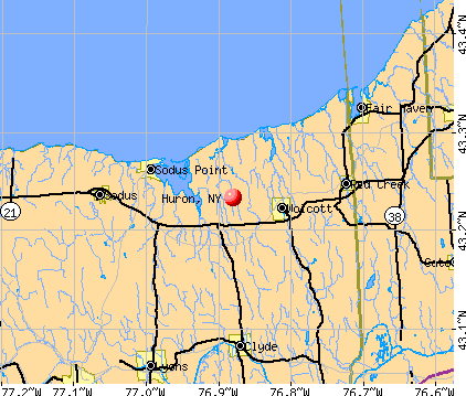
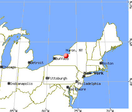
Huron, New York
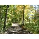
Huron: Driveway in the woods
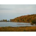
Huron: A view of East Bay in the fall
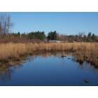
Huron: A section of East Bay
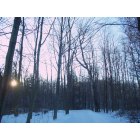
Huron: Huron woods in the Winter
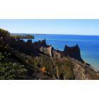
Huron: Chimney Bluffs State Park, fall 2007, taken from the trail
- add
your


Submit your own pictures of this town and show them to the world
- OSM Map
- General Map
- Google Map
- MSN Map
Population change since 2000: +0.0%
 |
| Males: 1,098 | |
| Females: 1,020 |
| Median resident age: | 46.4 years |
| New York median age: | 40.7 years |
Zip codes: 14590.
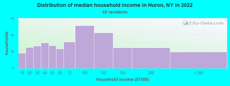
| Huron: | $66,623 |
| NY: | $79,557 |
Estimated per capita income in 2022: $36,524 (it was $19,648 in 2000)
Huron town income, earnings, and wages data
Estimated median house or condo value in 2022: $169,988 (it was $86,800 in 2000)
| Huron: | $169,988 |
| NY: | $400,400 |
Mean prices in 2022: all housing units: $177,416; detached houses: $194,685; townhouses or other attached units: $174,832; in 2-unit structures: $148,309; in 3-to-4-unit structures: $91,913; in 5-or-more-unit structures: $195,849; mobile homes: $52,467; occupied boats, rvs, vans, etc.: $19,284
Detailed information about poverty and poor residents in Huron, NY


- 1,95292.2%White alone
- 964.5%Hispanic
- 452.1%Black alone
- 130.6%Two or more races
- 60.3%Asian alone
- 50.2%American Indian alone
- 10.05%Native Hawaiian and Other
Pacific Islander alone
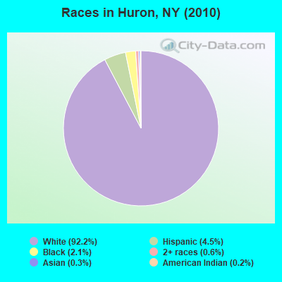
Races in Huron detailed stats: ancestries, foreign born residents, place of birth
 Recent articles from our blog. Our writers, many of them Ph.D. graduates or candidates, create easy-to-read articles on a wide variety of topics.


 | Crane watch map (341 replies) |
| smaller Upstate NY cities and towns/African American communities (5935 replies) |
| For those interested in Binghamton development/news/events, etc... (417 replies) |
| Buffalo--Boom or Bust (849 replies) |
| Google Street View Reveals More of Buffalo's Transformation Since 2007 (43 replies) |
| For those interested in Technology and Economic activity in Upstate NY... (2799 replies) |
Latest news from Huron, NY collected exclusively by city-data.com from local newspapers, TV, and radio stations
Ancestries: German (22.3%), English (19.1%), Irish (16.7%), Dutch (12.3%), Italian (8.4%), United States (7.6%).
Current Local Time: EST time zone
Elevation: 390 feet
Land area: 39.5 square miles.
Population density: 54 people per square mile (very low).
11 residents are foreign born
| This town: | 0.5% |
| New York: | 20.4% |
| Huron town: | 2.4% ($2,052) |
| New York: | 1.9% ($2,847) |
Nearest city with pop. 50,000+: Irondequoit, NY  (34.4 miles , pop. 52,354).
Nearest city with pop. 200,000+: Rochester, NY (36.5 miles , pop. 219,773).
Nearest city with pop. 1,000,000+: Bronx, NY (226.9 miles , pop. 1,332,650).
Nearest cities:
), ), Latitude: 43.24 N, Longitude: 76.89 W
Area code commonly used in this area: 315

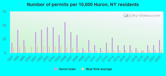
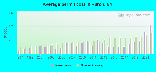
Single-family new house construction building permits:
- 2022: 5 buildings, average cost: $522,000
- 2021: 3 buildings, average cost: $397,000
- 2020: 3 buildings, average cost: $244,000
- 2019: 1 building, cost: $208,000
- 2018: 2 buildings, average cost: $181,300
- 2017: 3 buildings, average cost: $133,400
- 2016: 3 buildings, average cost: $133,300
- 2015: 3 buildings, average cost: $118,300
- 2014: 6 buildings, average cost: $133,000
- 2013: 4 buildings, average cost: $196,300
- 2012: 2 buildings, average cost: $262,500
- 2011: 3 buildings, average cost: $140,000
- 2010: 5 buildings, average cost: $232,000
- 2009: 2 buildings, average cost: $190,000
- 2008: 7 buildings, average cost: $151,700
- 2007: 8 buildings, average cost: $197,500
- 2006: 12 buildings, average cost: $190,500
- 2005: 7 buildings, average cost: $101,700
- 2004: 10 buildings, average cost: $78,400
- 2003: 10 buildings, average cost: $146,500
- 2002: 9 buildings, average cost: $123,200
- 2001: 8 buildings, average cost: $144,400
- 1999: 5 buildings, average cost: $100,200
- 1998: 9 buildings, average cost: $83,200
- 1997: 4 buildings, average cost: $46,500
| Here: | 4.0% |
| New York: | 4.4% |
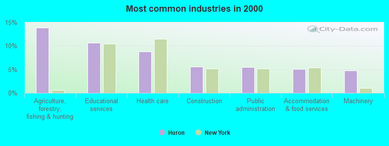
- Agriculture, forestry, fishing & hunting (13.9%)
- Educational services (10.7%)
- Health care (8.8%)
- Construction (5.6%)
- Public administration (5.5%)
- Accommodation & food services (5.1%)
- Machinery (4.7%)
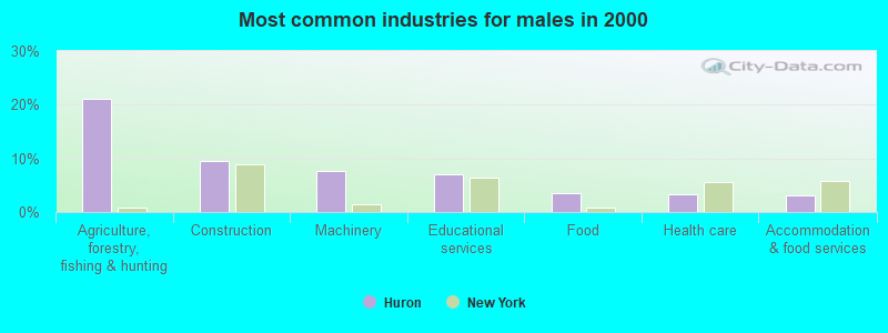
- Agriculture, forestry, fishing & hunting (21.0%)
- Construction (9.5%)
- Machinery (7.7%)
- Educational services (7.0%)
- Food (3.4%)
- Health care (3.2%)
- Accommodation & food services (3.1%)
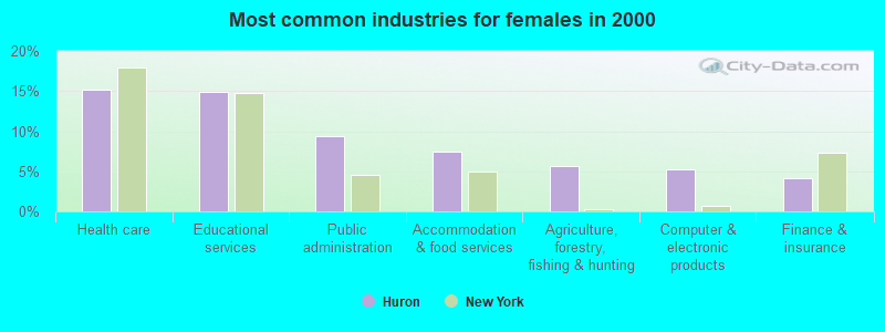
- Health care (15.1%)
- Educational services (14.9%)
- Public administration (9.3%)
- Accommodation & food services (7.5%)
- Agriculture, forestry, fishing & hunting (5.6%)
- Computer & electronic products (5.2%)
- Finance & insurance (4.1%)
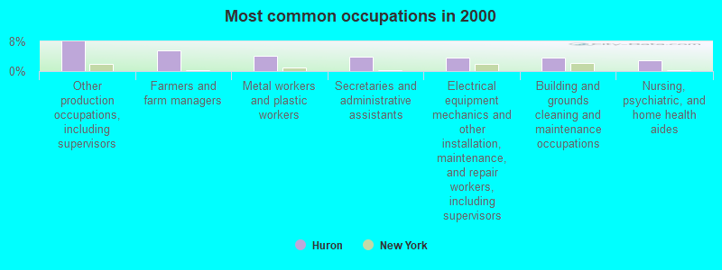
- Other production occupations, including supervisors (8.0%)
- Farmers and farm managers (5.6%)
- Metal workers and plastic workers (4.2%)
- Secretaries and administrative assistants (3.9%)
- Electrical equipment mechanics and other installation, maintenance, and repair workers, including supervisors (3.8%)
- Building and grounds cleaning and maintenance occupations (3.7%)
- Nursing, psychiatric, and home health aides (2.8%)
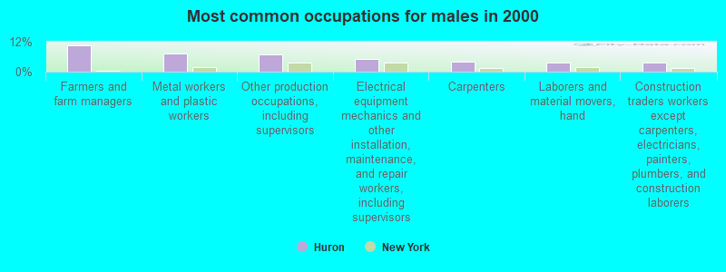
- Farmers and farm managers (10.4%)
- Metal workers and plastic workers (7.2%)
- Other production occupations, including supervisors (6.8%)
- Electrical equipment mechanics and other installation, maintenance, and repair workers, including supervisors (5.2%)
- Carpenters (4.0%)
- Laborers and material movers, hand (3.8%)
- Construction traders workers except carpenters, electricians, painters, plumbers, and construction laborers (3.6%)
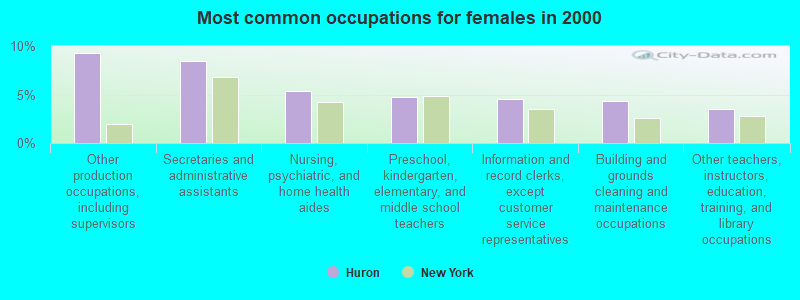
- Other production occupations, including supervisors (9.3%)
- Secretaries and administrative assistants (8.5%)
- Nursing, psychiatric, and home health aides (5.4%)
- Preschool, kindergarten, elementary, and middle school teachers (4.8%)
- Information and record clerks, except customer service representatives (4.6%)
- Building and grounds cleaning and maintenance occupations (4.3%)
- Other teachers, instructors, education, training, and library occupations (3.5%)
Average climate in Huron, New York
Based on data reported by over 4,000 weather stations


Earthquake activity:
Huron-area historical earthquake activity is significantly above New York state average. It is 68% smaller than the overall U.S. average.On 10/7/1983 at 10:18:46, a magnitude 5.3 (5.1 MB, 5.3 LG, 5.1 ML, Class: Moderate, Intensity: VI - VII) earthquake occurred 137.0 miles away from Huron center
On 4/20/2002 at 10:50:47, a magnitude 5.3 (5.3 ML, Depth: 3.0 mi) earthquake occurred 182.1 miles away from Huron center
On 4/20/2002 at 10:50:47, a magnitude 5.2 (5.2 MB, 4.2 MS, 5.2 MW, 5.0 MW) earthquake occurred 180.3 miles away from the city center
On 9/25/1998 at 19:52:52, a magnitude 5.2 (4.8 MB, 4.3 MS, 5.2 LG, 4.5 MW, Depth: 3.1 mi) earthquake occurred 216.0 miles away from Huron center
On 8/23/2011 at 17:51:04, a magnitude 5.8 (5.8 MW, Depth: 3.7 mi) earthquake occurred 372.7 miles away from Huron center
On 1/31/1986 at 16:46:43, a magnitude 5.0 (5.0 MB) earthquake occurred 245.5 miles away from Huron center
Magnitude types: regional Lg-wave magnitude (LG), body-wave magnitude (MB), local magnitude (ML), surface-wave magnitude (MS), moment magnitude (MW)
Natural disasters:
The number of natural disasters in Wayne County (14) is near the US average (15).Major Disasters (Presidential) Declared: 7
Emergencies Declared: 6
Causes of natural disasters: Floods: 3, Storms: 3, Hurricanes: 2, Winter Storms: 2, Blizzard: 1, Ice Storm: 1, Power Outage: 1, Tropical Storm: 1, Wind: 1, Other: 2 (Note: some incidents may be assigned to more than one category).

Colleges/universities with over 2000 students nearest to Huron:
- SUNY College at Oswego (about 23 miles; Oswego, NY; Full-time enrollment: 7,550)
- Hobart William Smith Colleges (about 27 miles; Geneva, NY; FT enrollment: 2,476)
- Cayuga County Community College (about 28 miles; Auburn, NY; FT enrollment: 3,141)
- Finger Lakes Community College (about 32 miles; Canandaigua, NY; FT enrollment: 4,732)
- Saint John Fisher College (about 33 miles; Rochester, NY; FT enrollment: 3,373)
- Nazareth College (about 33 miles; Rochester, NY; FT enrollment: 2,632)
- Monroe Community College (about 38 miles; Rochester, NY; FT enrollment: 14,295)
Points of interest:
Notable locations in Huron: Thorpe Vineyard (A), Sodus Bay Yacht Club (B), Skippers Landing Marina (C), Lake Bluff Campground (D). Display/hide their locations on the map
Churches in Huron include: Saint Johns Chapel (A), Huron Presbyterian Church (B). Display/hide their locations on the map
Cemeteries: Huron Evergreen Cemetery (1), York Settlement Cemetery (2). Display/hide their locations on the map
Swamps: Root Swamp (A), Brush Marsh (B). Display/hide their locations on the map
Creeks: Beaver Creek (A), Third Creek (B), Sodus Creek (C), Mudge Creek (D), Clark Creek (E). Display/hide their locations on the map
Beach: Crescent Beach (A). Display/hide its location on the map
| This town: | 2.4 people |
| New York: | 2.6 people |
| This town: | 69.0% |
| Whole state: | 63.5% |
| This town: | 9.9% |
| Whole state: | 6.8% |
Likely homosexual households (counted as self-reported same-sex unmarried-partner households)
- Lesbian couples: 0.6% of all households
- Gay men: 0.2% of all households
| This town: | 12.6% |
| Whole state: | 14.6% |
| This town: | 5.4% |
| Whole state: | 7.4% |
People in group quarters in Huron in 2010:
- 20 people in correctional residential facilities
- 17 people in local jails and other municipal confinement facilities
- 8 people in group homes intended for adults
- 5 people in workers' group living quarters and job corps centers
People in group quarters in Huron in 2000:
- 29 people in other group homes
- 11 people in homes for the mentally retarded
- 6 people in agriculture workers' dormitories on farms
For population 15 years and over in Huron:
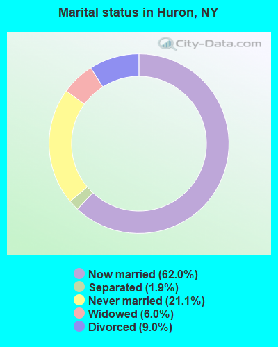
- Never married: 21.1%
- Now married: 62.0%
- Separated: 1.9%
- Widowed: 6.0%
- Divorced: 9.0%
For population 25 years and over in Huron:
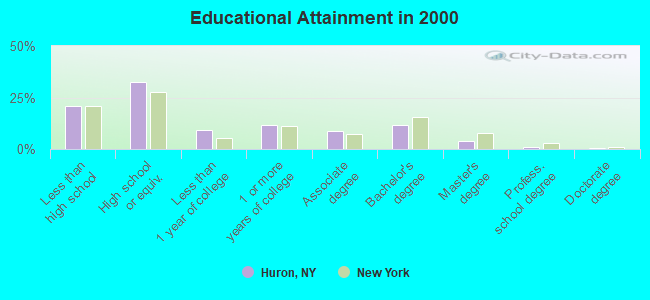
- High school or higher: 79.2%
- Bachelor's degree or higher: 16.6%
- Graduate or professional degree: 5.2%
- Unemployed: 5.3%
- Mean travel time to work (commute): 30.5 minutes
| Here: | 12.1 |
| New York average: | 14.2 |
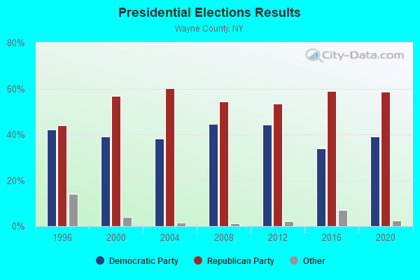
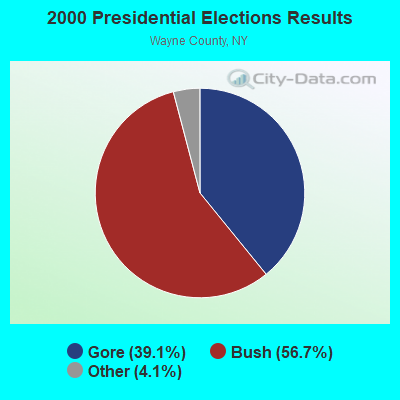
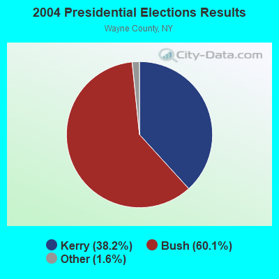
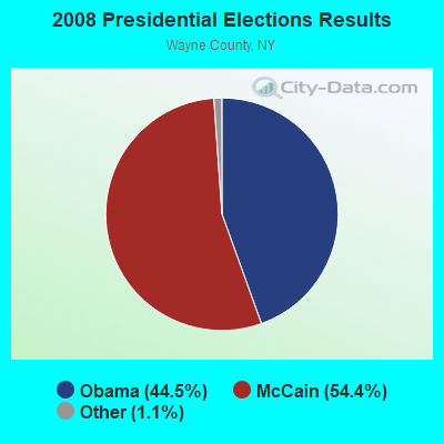
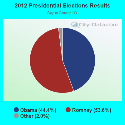
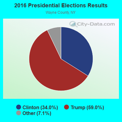
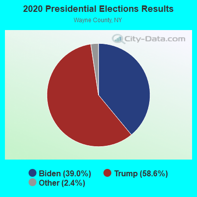
Graphs represent county-level data. Detailed 2008 Election Results
Religion statistics for Huron, NY (based on Wayne County data)
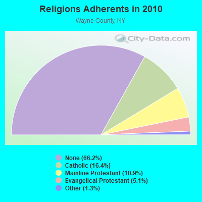
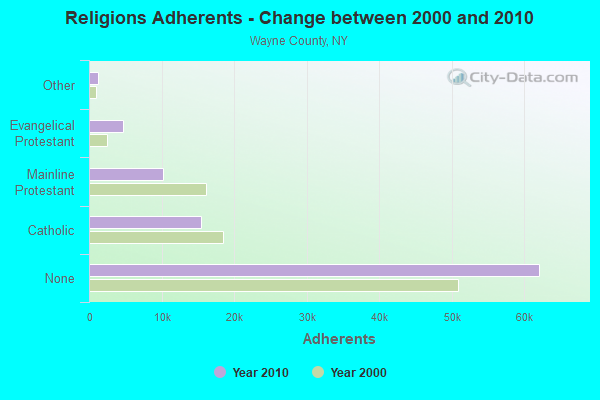
| Religion | Adherents | Congregations |
|---|---|---|
| Catholic | 15,422 | 8 |
| Mainline Protestant | 10,259 | 57 |
| Evangelical Protestant | 4,743 | 44 |
| Other | 1,254 | 5 |
| Black Protestant | - | 2 |
| None | 62,094 | - |
Food Environment Statistics:
| This county: | 1.75 / 10,000 pop. |
| State: | 4.13 / 10,000 pop. |
| Here: | 0.66 / 10,000 pop. |
| New York: | 0.92 / 10,000 pop. |
| Wayne County: | 4.59 / 10,000 pop. |
| State: | 1.68 / 10,000 pop. |
| Wayne County: | 5.90 / 10,000 pop. |
| New York: | 8.82 / 10,000 pop. |
| Here: | 8.9% |
| New York: | 8.2% |
| Wayne County: | 25.4% |
| New York: | 23.8% |
| Wayne County: | 14.0% |
| State: | 15.6% |
Strongest AM radio stations in Huron:
- WHAM (1180 AM; 50 kW; ROCHESTER, NY; Owner: CITICASTERS LICENSES, L.P.)
- WACK (1420 AM; 5 kW; NEWARK, NY; Owner: PEMBROOK PINES, INC.)
- WHEN (620 AM; 5 kW; SYRACUSE, NY; Owner: CLEAR CHANNEL BROADCASTING LICENSES, INC.)
- WSYR (570 AM; 5 kW; SYRACUSE, NY; Owner: CLEAR CHANNEL BROADCASTING LICENSES, INC.)
- WWKB (1520 AM; 50 kW; BUFFALO, NY; Owner: ENTERCOM BUFFALO LICENSE, LLC)
- WHTK (1280 AM; 5 kW; ROCHESTER, NY)
- WFBL (1050 AM; 2 kW; BALDWINSVILLE, NY; Owner: BUCKLEY BROADCASTING CORPORATION)
- WXXI (1370 AM; 5 kW; ROCHESTER, NY; Owner: WXXI PUBLIC BROADCASTING COUNCIL)
- WDCW (1390 AM; 5 kW; SYRACUSE, NY; Owner: KIMTRON, INC.)
- WHIC (1460 AM; 5 kW; ROCHESTER, NY; Owner: HOLY FAMILY COMMUNICATIONS)
- WGY (810 AM; 50 kW; SCHENECTADY, NY; Owner: CLEAR CHANNEL BROADCASTING LICENSES, INC.)
- WLGZ (990 AM; 5 kW; ROCHESTER, NY; Owner: KIMTRON, INC.)
- WNSS (1260 AM; 5 kW; SYRACUSE, NY; Owner: CITADEL BROADCASTING COMPANY)
Strongest FM radio stations in Huron:
- WCOV-FM (93.7 FM; CLYDE, NY; Owner: FAMILY LIFE MINISTRIES, INC.)
- WFRW (88.1 FM; WEBSTER, NY; Owner: FAMILY STATIONS, INC.)
- WUUF (103.5 FM; SODUS, NY; Owner: WAYNCO RADIO)
- WPHR (106.9 FM; AUBURN, NY; Owner: CLEAR CHANNEL BROADCASTING LICENSES, INC.)
- WRVO (89.9 FM; OSWEGO, NY; Owner: STATE UNIVERSITY OF NEW YORK)
- WISY (102.3 FM; CANANDAIGUA, NY; Owner: CITICASTERS LICENSES, L.P.)
- WCIY (88.9 FM; CANANDAIGUA, NY; Owner: FAMILY LIFE MINISTRIES, INC.)
- WBBS (104.7 FM; FULTON, NY; Owner: CITICASTERS LICENSES, L.P.)
- WFXF (107.3 FM; SOUTH BRISTOL TOWNSH, NY; Owner: CITICASTERS LICENSES, L.P.)
- WNVE (95.1 FM; HONEOYE FALLS, NY; Owner: CITICASTERS LICENSES, L.P.)
- WTKV (105.5 FM; OSWEGO, NY; Owner: GALAXY COMMUNICATIONS, L.P.)
- WBEE-FM (92.5 FM; ROCHESTER, NY; Owner: ENTERCOM ROCHESTER LICENSE, LLC.)
- WLLW (99.3 FM; SENECA FALLS, NY; Owner: AUBURN BROADCASTING, INC.)
- WZXV (99.7 FM; PALMYRA, NY; Owner: CALVARY CHAPEL OF FINGER LAKES, INC.)
- WVOR-FM (100.5 FM; ROCHESTER, NY; Owner: CITICASTERS LICENSES, L.P.)
- WNYR-FM (98.5 FM; WATERLOO, NY; Owner: LAKE COUNTRY BROADCASTING, INC.)
- WKRH (106.5 FM; MINETTO, NY; Owner: GALAXY COMMUNICATIONS, L.P.)
TV broadcast stations around Huron:
- WCNY-TV (Channel 24; SYRACUSE, NY; Owner: PUBLIC BROADCASTING COUNCIL OF CENTRAL NEW YORK)
- WSPX-TV (Channel 56; SYRACUSE, NY; Owner: PAXSON SYRACUSE LICENSE, INC.)
- WSYT (Channel 68; SYRACUSE, NY; Owner: WSYT LICENSEE L.P.)
- WNYS-TV (Channel 43; SYRACUSE, NY; Owner: RKM MEDIA, INC.)
- WBGT-LP (Channel 40; ROCHESTER, NY; Owner: WBGT, LLC)
- National Bridge Inventory (NBI) Statistics
- 4Number of bridges
- 95ft / 29.2mTotal length
- $12,271,000Total costs
- 16,462Total average daily traffic
- 2,102Total average daily truck traffic
- 16,813Total future (year 2037) average daily traffic
FCC Registered Broadcast Land Mobile Towers:
1- Station 217, Wilson St Rd Near Corner Of Brown Rd. (Lat: 43.211806 Lon: -76.868444), Type: Upole, Structure height: 9.1 m, Call Sign: WPXU761,
Assigned Frequencies: 173.203 MHz, 173.396 MHz, Grant Date: 04/14/2023, Expiration Date: 06/13/2033, Certifier: Donald H Regoord, Registrant: Utilities Technology Council, 2550 South Clark St., Suite 960, Arlington, VA 22202, Phone: (203) 833-6818, Email:
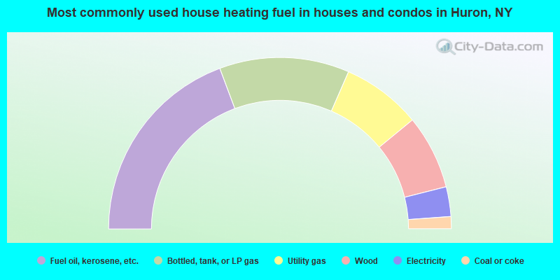
- 38.6%Fuel oil, kerosene, etc.
- 24.5%Bottled, tank, or LP gas
- 15.0%Utility gas
- 14.0%Wood
- 5.6%Electricity
- 2.3%Coal or coke
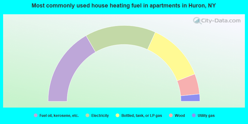
- 33.3%Fuel oil, kerosene, etc.
- 30.2%Electricity
- 24.7%Bottled, tank, or LP gas
- 8.6%Wood
- 3.1%Utility gas
Huron compared to New York state average:
- Median house value significantly below state average.
- Unemployed percentage significantly below state average.
- Black race population percentage significantly below state average.
- Hispanic race population percentage significantly below state average.
- Median age above state average.
- Foreign-born population percentage significantly below state average.
- Renting percentage significantly below state average.
- Length of stay since moving in significantly above state average.
- Number of rooms per house significantly below state average.
- House age significantly below state average.
- Percentage of population with a bachelor's degree or higher below state average.
Huron on our top lists:
- #70 on the list of "Top 101 cities with the largest percentage of people in other group homes (population 1,000+)"
- #70 on the list of "Top 101 counties with the largest number of people moving out compared to moving in (pop. 50,000+)"