Jemez, New Mexico
Submit your own pictures of this place and show them to the world
- OSM Map
- General Map
- Google Map
- MSN Map

| Males: 3,005 | |
| Females: 3,199 |
| Median resident age: | 35.5 years |
| New Mexico median age: | 34.6 years |
Zip code: 87025
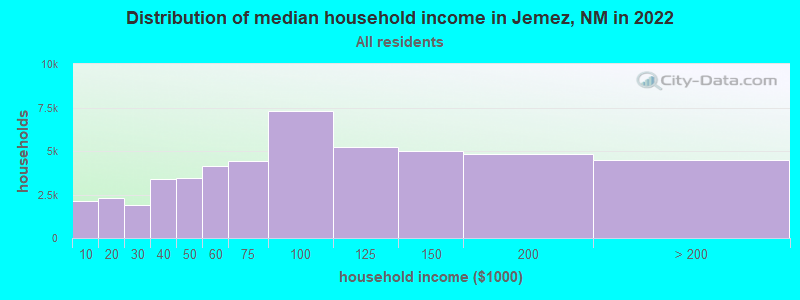
| Jemez: | $70,578 |
| NM: | $59,726 |
Estimated per capita income in 2022: $32,033 (it was $14,869 in 2000)
Jemez CCD income, earnings, and wages data
Estimated median house or condo value in 2022: $279,879 (it was $99,000 in 2000)
| Jemez: | $279,879 |
| NM: | $243,100 |
Mean prices in 2022: all housing units: $429,203; detached houses: $425,810; townhouses or other attached units: $531,327; in 2-unit structures: $180,627; in 3-to-4-unit structures: $135,601; in 5-or-more-unit structures: $162,590; mobile homes: $459,468; occupied boats, rvs, vans, etc.: $28,275
Detailed information about poverty and poor residents in Jemez, NM


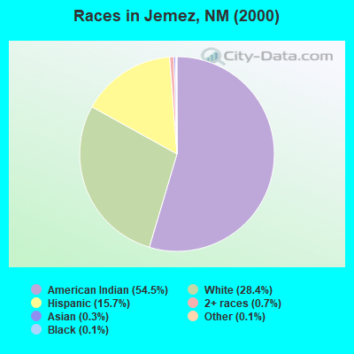
- 2,62054.5%American Indian alone
- 1,36728.4%White alone
- 75415.7%Hispanic
- 350.7%Two or more races
- 150.3%Asian alone
- 60.1%Black alone
- 70.1%Other race alone
- 10.02%Native Hawaiian and Other
Pacific Islander alone
Races in Jemez detailed stats: ancestries, foreign born residents, place of birth
 Recent articles from our blog. Our writers, many of them Ph.D. graduates or candidates, create easy-to-read articles on a wide variety of topics.

Current Local Time: MST time zone
Land area: 761.5 square miles.
Population density: 8.1 people per square mile (very low).

| Jemez CCD: | 0.5% ($467) |
| New Mexico: | 0.7% ($699) |
Nearest city with pop. 50,000+: Rio Rancho, NM  (34.7 miles , pop. 51,765).
Nearest city with pop. 200,000+: Albuquerque, NM (46.9 miles , pop. 448,607).
Nearest city with pop. 1,000,000+: Phoenix, AZ (344.6 miles , pop. 1,321,045).
Nearest cities:
), ), ), ), Latitude: 35.79 N, Longitude: 106.68 W
Area code commonly used in this area: 505

| Here: | 3.6% |
| New Mexico: | 3.6% |
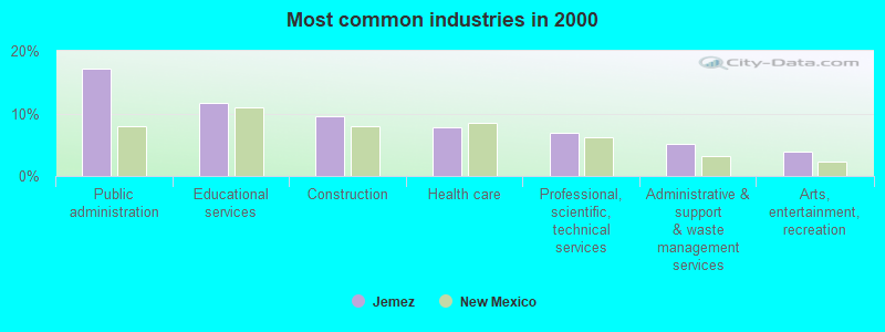
- Public administration (17.2%)
- Educational services (11.7%)
- Construction (9.6%)
- Health care (7.7%)
- Professional, scientific, technical services (6.8%)
- Administrative & support & waste management services (5.2%)
- Arts, entertainment, recreation (3.9%)
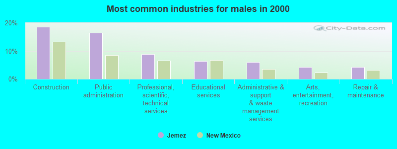
- Construction (18.6%)
- Public administration (16.5%)
- Professional, scientific, technical services (8.9%)
- Educational services (6.3%)
- Administrative & support & waste management services (6.0%)
- Arts, entertainment, recreation (4.3%)
- Repair & maintenance (4.2%)
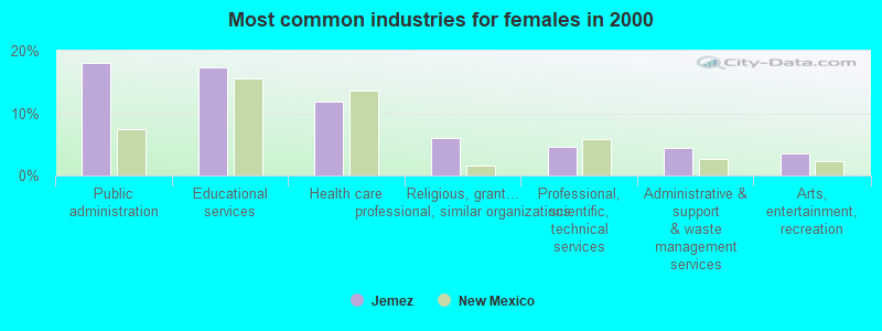
- Public administration (18.0%)
- Educational services (17.4%)
- Health care (11.9%)
- Religious, grantmaking, civic, professional, similar organizations (6.0%)
- Professional, scientific, technical services (4.6%)
- Administrative & support & waste management services (4.4%)
- Arts, entertainment, recreation (3.6%)
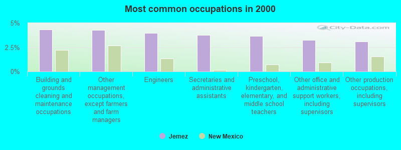
- Building and grounds cleaning and maintenance occupations (4.3%)
- Other management occupations, except farmers and farm managers (4.3%)
- Engineers (3.9%)
- Secretaries and administrative assistants (3.8%)
- Preschool, kindergarten, elementary, and middle school teachers (3.7%)
- Other office and administrative support workers, including supervisors (3.3%)
- Other production occupations, including supervisors (3.1%)
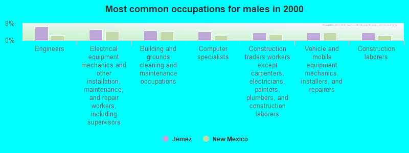
- Engineers (6.6%)
- Electrical equipment mechanics and other installation, maintenance, and repair workers, including supervisors (5.2%)
- Building and grounds cleaning and maintenance occupations (4.6%)
- Computer specialists (4.1%)
- Construction traders workers except carpenters, electricians, painters, plumbers, and construction laborers (3.7%)
- Vehicle and mobile equipment mechanics, installers, and repairers (3.5%)
- Construction laborers (3.5%)
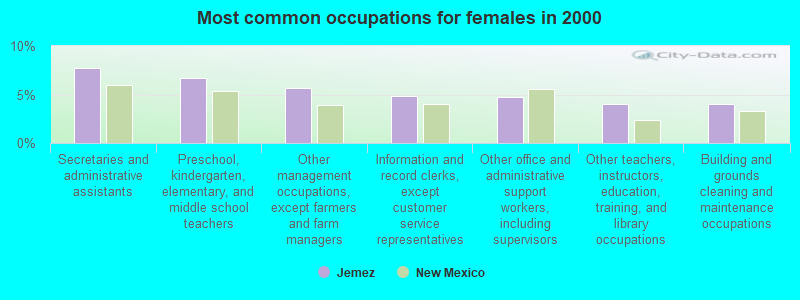
- Secretaries and administrative assistants (7.7%)
- Preschool, kindergarten, elementary, and middle school teachers (6.7%)
- Other management occupations, except farmers and farm managers (5.6%)
- Information and record clerks, except customer service representatives (4.8%)
- Other office and administrative support workers, including supervisors (4.7%)
- Other teachers, instructors, education, training, and library occupations (4.0%)
- Building and grounds cleaning and maintenance occupations (4.0%)
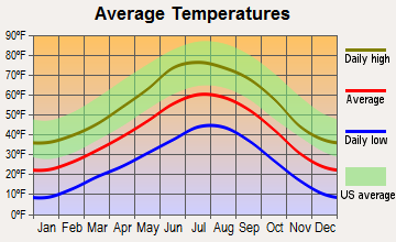
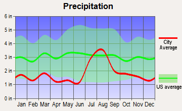
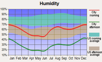
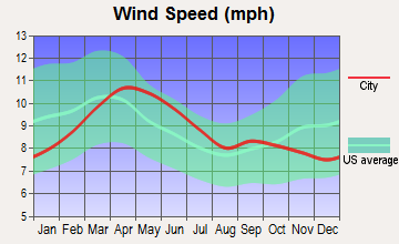
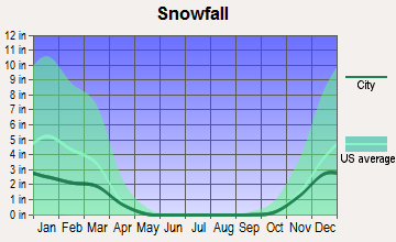
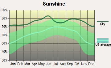
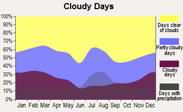
Average climate in Jemez, New Mexico
Based on data reported by over 4,000 weather stations
(lower is better)
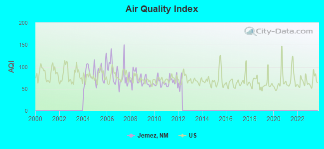
Air Quality Index (AQI) level in 2011 was 66.8. This is about average.
| City: | 66.8 |
| U.S.: | 72.6 |
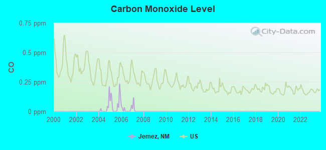
Carbon Monoxide (CO) [ppm] level in 2007 was 0.0172. This is significantly better than average. Closest monitor was 12.2 miles away from the city center.
| City: | 0.0172 |
| U.S.: | 0.2513 |
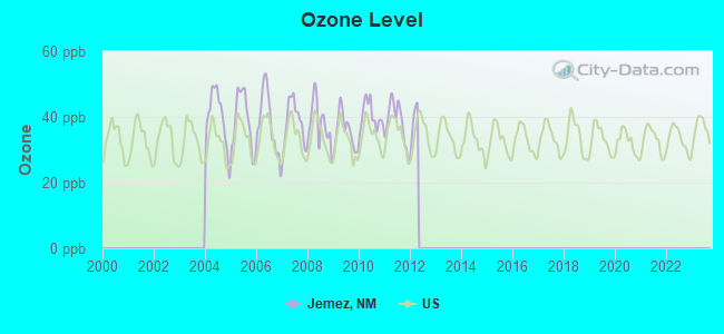
Ozone [ppb] level in 2011 was 38.3. This is about average. Closest monitor was 12.2 miles away from the city center.
| City: | 38.3 |
| U.S.: | 33.3 |
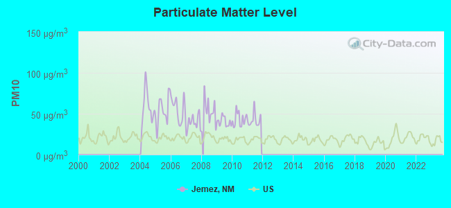
Particulate Matter (PM10) [µg/m3] level in 2011 was 42.1. This is significantly worse than average. Closest monitor was 12.2 miles away from the city center.
| City: | 42.1 |
| U.S.: | 19.2 |
Earthquake activity:
Jemez-area historical earthquake activity is significantly above New Mexico state average. It is 849% greater than the overall U.S. average.On 8/23/2011 at 05:46:18, a magnitude 5.3 (5.3 MW, Depth: 2.5 mi, Class: Moderate, Intensity: VI - VII) earthquake occurred 141.0 miles away from Jemez center
On 6/28/1992 at 11:57:34, a magnitude 7.6 (6.2 MB, 7.6 MS, 7.3 MW, Depth: 0.7 mi, Class: Major, Intensity: VIII - XII) earthquake occurred 569.1 miles away from Jemez center, causing 3 deaths (1 shaking deaths, 2 other deaths) and 400 injuries, causing $100,000,000 total damage and $40,000,000 insured losses
On 10/16/1999 at 09:46:44, a magnitude 7.4 (6.3 MB, 7.4 MS, 7.2 MW, 7.3 ML) earthquake occurred 558.6 miles away from Jemez center
On 8/10/2005 at 22:08:22, a magnitude 5.0 (5.0 MW, Depth: 3.1 mi) earthquake occurred 130.3 miles away from the city center
On 8/10/2005 at 22:08:22, a magnitude 5.0 (5.0 MB, 4.7 MS, 5.0 MW) earthquake occurred 132.1 miles away from the city center
On 1/29/1990 at 13:16:10, a magnitude 4.8 (4.5 MB, 4.8 LG, Depth: 7.5 mi, Class: Light, Intensity: IV - V) earthquake occurred 92.3 miles away from the city center
Magnitude types: regional Lg-wave magnitude (LG), body-wave magnitude (MB), local magnitude (ML), surface-wave magnitude (MS), moment magnitude (MW)
Natural disasters:
The number of natural disasters in Sandoval County (18) is near the US average (15).Major Disasters (Presidential) Declared: 9
Emergencies Declared: 3
Causes of natural disasters: Floods: 8, Fires: 7, Storms: 6, Drought: 1, Hurricane: 1, Mudslide: 1, Snow: 1, Other: 1 (Note: some incidents may be assigned to more than one category).
Colleges/universities with over 2000 students nearest to Jemez:
- Santa Fe Community College (about 41 miles; Santa Fe, NM; Full-time enrollment: 3,047)
- University of Phoenix-Albuquerque Campus (about 42 miles; Albuquerque, NM; FT enrollment: 2,335)
- University of New Mexico-Main Campus (about 49 miles; Albuquerque, NM; FT enrollment: 23,042)
- Central New Mexico Community College (about 50 miles; Albuquerque, NM; FT enrollment: 19,398)
- New Mexico Highlands University (about 83 miles; Las Vegas, NM; FT enrollment: 2,931)
- San Juan College (about 108 miles; Farmington, NM; FT enrollment: 5,112)
- Fort Lewis College (about 123 miles; Durango, CO; FT enrollment: 3,631)
Points of interest:
Notable locations in Jemez: APS Camp (A), Headquarters Ranch (B), Fenton Ranch (C), Cañon Landing (D), Jemez Falls Campgrounds (E), Rancho del Chaparral (F), Redondo Campground (G), Rio las Vacas Campground (H), San Antonio Campground (I), Seven Springs Campground (J), East Fork Recreation Site (K), Jemez Falls Campground (L), Indian Head Picnic Ground (M), Jemez Mountains Sanitary Landfill (N), Sacred Area San Ildefonso Indian Reservation (O), Vista Linda Campground (P), Spanish Queen Picnic Area (Q), Dark Canyon Picnic Ground (R), Camp Shaver (S), Calaveras Campground (T). Display/hide their locations on the map
Churches in Jemez include: Via Coeli Monastery (A), Jemez Valley Church (B), Nuestra Senora de Guadalupe Church (C), Community Presbyterian Church (D). Display/hide their locations on the map
Cemeteries: Jemez Springs Catholic Cemetery (1), San Ysidro Cemetery (2). Display/hide their locations on the map
Lakes, reservoirs, and swamps: Sheep Fish Pond (A), Cebollita Tank (B), Tusas Tank (C), Fenton Lake (D), Cass Tank (E), Peñasco Tank (F), Lower Vallecito Reservoir (G), Calaveras Well (H). Display/hide their locations on the map
Streams, rivers, and creeks: Arroyo Alamito (A), Arroyo Alamo (B), Cuchilla Arroyo (C), Rito de los Indios (D), Turkey Creek (E), Trail Creek (F), Stable Canyon Fork (G), San Luis Creek (H), Rito Olguin (I). Display/hide their locations on the map
Parks in Jemez include: Fenton Lake State Park (1), Jemez National Recreation Area (2), Vasquez de Coronados Route Historical Marker (3), Valle Grande Historical Marker (4), Soda Dam Historical Marker (5), Valles Caldera National Preserve (6), Jemez Mountains Historical Marker (7), Fenton Lake State Park (8), Jemez State Monument (9). Display/hide their locations on the map
| This place: | 3.2 people |
| New Mexico: | 2.6 people |
| This place: | 72.5% |
| Whole state: | 69.2% |
| This place: | 6.8% |
| Whole state: | 6.4% |
Likely homosexual households (counted as self-reported same-sex unmarried-partner households)
- Lesbian couples: 0.7% of all households
- Gay men: 0.2% of all households
| This place: | 17.7% |
| Whole state: | 18.4% |
| This place: | 8.0% |
| Whole state: | 7.8% |
8 people in other nonhousehold living situations in 2000
For population 15 years and over in Jemez:
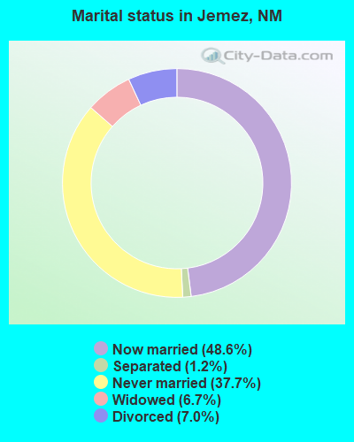
- Never married: 37.7%
- Now married: 48.6%
- Separated: 1.2%
- Widowed: 6.7%
- Divorced: 7.0%
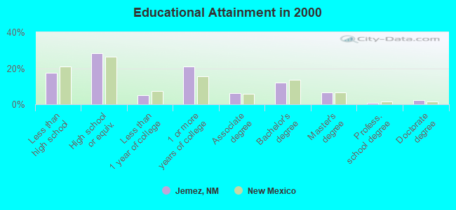
For population 25 years and over in Jemez:
- High school or higher: 82.4%
- Bachelor's degree or higher: 22.0%
- Graduate or professional degree: 9.9%
- Unemployed: 11.3%
- Mean travel time to work (commute): 36.4 minutes
| Here: | 12.2 |
| New Mexico average: | 14.5 |
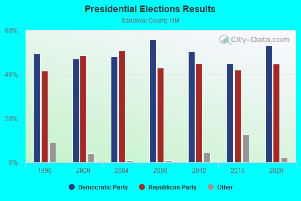
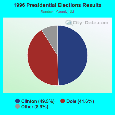
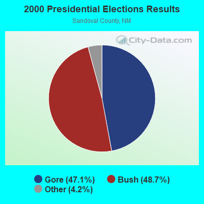
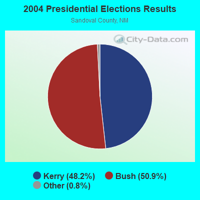
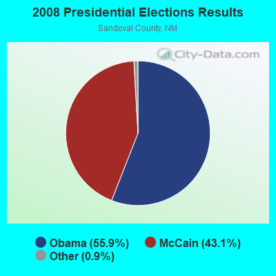
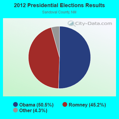
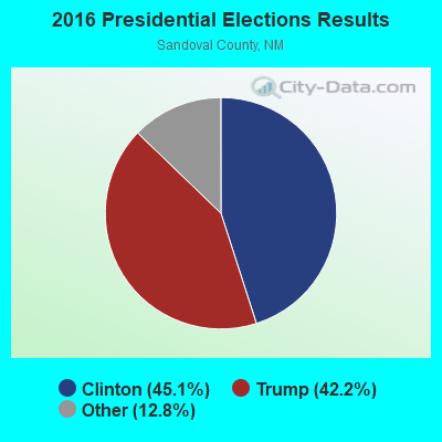
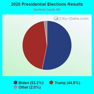
Graphs represent county-level data. Detailed 2008 Election Results
Religion statistics for Jemez, NM (based on Sandoval County data)
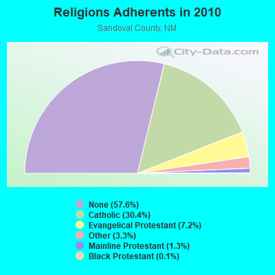
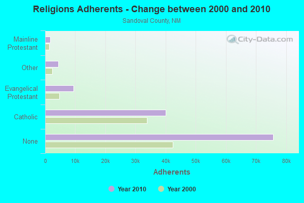
| Religion | Adherents | Congregations |
|---|---|---|
| Catholic | 40,035 | 25 |
| Evangelical Protestant | 9,421 | 44 |
| Other | 4,398 | 18 |
| Mainline Protestant | 1,741 | 9 |
| Black Protestant | 189 | 1 |
| None | 75,777 | - |
Food Environment Statistics:
| This county: | 1.19 / 10,000 pop. |
| New Mexico: | 1.44 / 10,000 pop. |
| Here: | 0.26 / 10,000 pop. |
| State: | 0.32 / 10,000 pop. |
| This county: | 2.38 / 10,000 pop. |
| New Mexico: | 4.06 / 10,000 pop. |
| This county: | 3.74 / 10,000 pop. |
| New Mexico: | 7.12 / 10,000 pop. |
| This county: | 6.4% |
| New Mexico: | 6.4% |
| Sandoval County: | 22.2% |
| New Mexico: | 22.1% |
9.68% of this county's 2021 resident taxpayers lived in other counties in 2020 ($69,075 average adjusted gross income)
| Here: | 9.68% |
| New Mexico average: | 6.50% |
0.05% of residents moved from foreign countries ($409 average AGI)
Sandoval County: 0.05% New Mexico average: 0.07%
Top counties from which taxpayers relocated into this county between 2020 and 2021:
| from Bernalillo County, NM | |
| from Santa Fe County, NM | |
| from Maricopa County, AZ |
Strongest AM radio stations in Jemez:
- KKOB (770 AM; 50 kW; ALBUQUERQUE, NM; Owner: CITADEL BROADCASTING COMPANY)
- KKIM (1000 AM; 10 kW; ALBUQUERQUE, NM; Owner: AGM-NEVADA, LLC)
- KTNN (660 AM; 50 kW; WINDOW ROCK, AZ; Owner: THE NAVAJO NATION)
- KSWV (810 AM; 5 kW; SANTA FE, NM; Owner: LA VOZ BROADCASTING CO., INC.)
- KANM (1600 AM; 10 kW; ALBUQUERQUE, NM; Owner: ARAGON BROADCASTING COMPANY, L.L.C.)
- KXKS (1190 AM; 10 kW; ALBUQUERQUE, NM; Owner: CLEAR CHANNEL BROADCASTING LICENSES, INC.)
- KDCE (950 AM; 4 kW; ESPANOLA, NM; Owner: RICHARD L. GARCIA BROADCASTING, INC.)
- KNML (610 AM; 5 kW; ALBUQUERQUE, NM; Owner: CITADEL BROADCASTING COMPANY)
- KHAC (880 AM; 43 kW; TSE BONITO, NM; Owner: WESTERN INDIAN MINISTRIES, INC.)
- KDEF (1150 AM; 5 kW; ALBUQUERQUE, NM; Owner: RAMH CORPORATION)
- KTRC (1260 AM; 5 kW; SANTA FE, NM; Owner: AGM NEVADA, LLC)
- KKNS (1310 AM; 5 kW; CORRALES, NM; Owner: SIMMONS-NM, LS, LLC)
- KABQ (1350 AM; 5 kW; ALBUQUERQUE, NM; Owner: CLEAR CHANNEL BROADCASTING LICENSES, INC.)
Strongest FM radio stations in Jemez:
- KAJZ (105.1 FM; SANTA FE, NM; Owner: HBC LICENSE CORPORATION)
- KRZY-FM (105.9 FM; SANTA FE, NM; Owner: ENTRAVISION HOLDINGS, LLC)
- KABG (98.5 FM; LOS ALAMOS, NM; Owner: AGM-NEVADA, L.L.C.)
- KBAC (104.1 FM; SANTA FE, NM; Owner: CITICASTERS LICENSES, L.P.)
- KKSS (97.3 FM; SANTA FE, NM; Owner: HBC LICENSE CORPORATION)
- KHFM (95.5 FM; SANTA FE, NM; Owner: AGM-NEVADA L.L.C)
- KZNM (106.7 FM; LOS ALAMOS, NM; Owner: AGM NEVADA, LLC)
- KLYT (88.3 FM; ALBUQUERQUE, NM; Owner: CONNECTION COMMUNICATIONS ASSOCIATION, INC.)
- KTZO (103.3 FM; ALBUQUERQUE, NM; Owner: CITADEL BROADCASTING COMPANY)
- KRST (92.3 FM; ALBUQUERQUE, NM; Owner: CITADEL BROADCASTING COMPANY)
- KUNM (89.9 FM; ALBUQUERQUE, NM; Owner: BOARD OF REGENTS UNIV. OF NEW MEXICO)
- KANW (89.1 FM; ALBUQUERQUE, NM; Owner: BD. OF EDUC. CITY OF ALBUQUERQUE, NM)
- KKOB-FM (93.3 FM; ALBUQUERQUE, NM; Owner: CITADEL BROADCASTING COMPANY)
- KBZU (96.3 FM; ALBUQUERQUE, NM; Owner: CITADEL BROADCASTING COMPANY)
- KMGA (99.5 FM; ALBUQUERQUE, NM; Owner: CITADEL BROADCASTING COMPANY)
- KZRR (94.1 FM; ALBUQUERQUE, NM; Owner: CLEAR CHANNEL BROADCASTING LICENSES, INC.)
- KPEK (100.3 FM; ALBUQUERQUE, NM; Owner: CITICASTERS LICENSES, L.P.)
- KBQI (107.9 FM; ALBUQUERQUE, NM; Owner: CITICASTERS LICENSES, L.P.)
- KSFQ (101.1 FM; WHITE ROCK, NM; Owner: CLEAR CHANNEL BROADCASTING LICENSES, INC.)
- KFLQ (91.5 FM; ALBUQUERQUE, NM; Owner: FAMILY LIFE BROADCASTING SYSTEM)
TV broadcast stations around Jemez:
- KCHF (Channel 11; SANTA FE, NM; Owner: SON BROADCASTING, INC.)
- KTFQ (Channel 14; ALBUQUERQUE, NM; Owner: TELEFUTURA TELEVISION GROUP, INC.)
- KWBQ (Channel 19; SANTA FE, NM; Owner: ACME TV LICENSES OF NEW MEXICO, LLC)
FCC Registered Commercial Land Mobile Towers:
1- 9.3 Mi East (Lat: 35.780583 Lon: -106.526972), Structure height: 91 m, Call Sign: KPG996, Licensee ID: L02155018,
Assigned Frequencies: 450.800 MHz, Grant Date: 11/17/1986, Expiration Date: 10/01/2029, Registrant: Gcbendito 4 LLC, 102 Taos Street, Santa Fe, NM 87505
FCC Registered Microwave Towers:
2- JEMEZ, 12 Mi Nw Of (Lat: 35.695278 Lon: -106.858639), Overall height: 17.1 m, Call Sign: KLD48,
Assigned Frequencies: 6226.90 MHz, 6197.20 MHz, 6241.70 MHz, 6256.50 MHz, 6301.00 MHz, 6315.90 MHz, 6360.30 MHz, Grant Date: 09/08/2010, Expiration Date: 08/01/2020, Cancellation Date: 12/19/2011, Registrant: Qwest Corporation, 700 W. Mineral Ave., Rm. Nd-E02.34, Littleton, CO 80120, Phone: (303) 707-8714, Fax: (303) 707-9624, Email:
- PAJARITO, 9.3 Mi Nw Of (Lat: 35.696667 Lon: -106.860028), Overall height: 27.7 m, Call Sign: WGX453,
Assigned Frequencies: 2165.60 MHz, Grant Date: 02/15/2011, Expiration Date: 02/01/2021, Cancellation Date: 06/22/2011, Registrant: Lukas, Nace, Gutierrez & Sachs, LLP, 8300 Greensboro Drive Suite 1200, Mclean, VA 22102, Phone: (703) 584-8676, Fax: (703) 584-8694, Email:
FCC Registered Paging Towers:
1- Pajarito Peak, 9.3 Miles Nw Of (Lat: 35.696667 Lon: -106.860028), Overall height: 27.7 m, Call Sign: KNKO494,
Assigned Frequencies: 931.037 MHz, Grant Date: 06/01/2015, Expiration Date: 03/02/2025, Registrant: Word Communications, 9016 Washington St Ne, Albuquerque, NM 87113, Phone: (505) 275-4664, Fax: (505) 888-2609, Email:
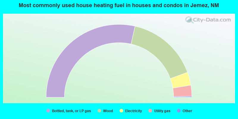
- 57.1%Bottled, tank, or LP gas
- 31.8%Wood
- 5.8%Electricity
- 4.9%Utility gas
- 0.2%Fuel oil, kerosene, etc.
- 0.2%Solar energy
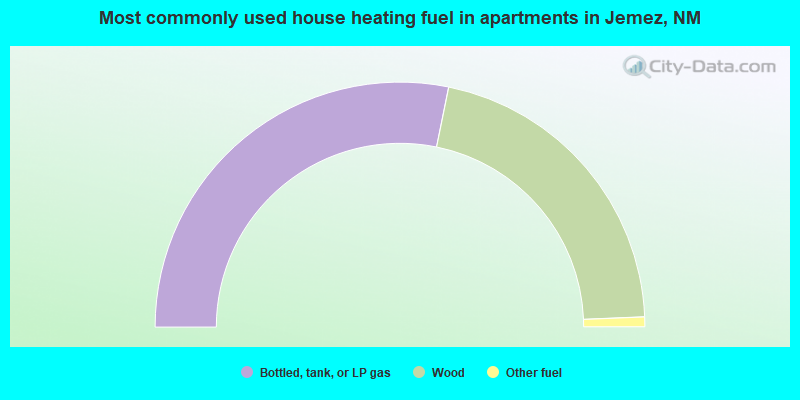
- 56.4%Bottled, tank, or LP gas
- 42.3%Wood
- 1.3%Other fuel
Jemez compared to New Mexico state average:
- Black race population percentage significantly below state average.
- Hispanic race population percentage significantly below state average.
- Foreign-born population percentage significantly below state average.
- Renting percentage significantly below state average.
- Length of stay since moving in significantly above state average.
- Number of rooms per house significantly below state average.
- House age significantly below state average.
Jemez on our top lists:
- #4 on the list of "Top 101 cities with largest percentage of females in industries: religious, grantmaking, civic, professional, and similar organizations (population 5,000+)"
- #10 on the list of "Top 101 cities with largest percentage of females in occupations: life and physical scientists (population 5,000+)"
- #13 on the list of "Top 101 cities with largest percentage of females in occupations: religious workers (population 5,000+)"
- #15 on the list of "Top 101 cities with the most people carpooling to work (population 5,000+)"
- #19 on the list of "Top 101 cities with largest percentage of females in industries: fuel dealers (population 5,000+)"
- #24 on the list of "Top 101 cities with largest percentage of females in occupations: motor vehicle operators except bus and truck drivers (population 5,000+)"
- #26 on the list of "Top 101 cities with largest percentage of males in occupations: therapists (population 5,000+)"
- #27 on the list of "Top 101 cities with largest percentage of females in occupations: bus drivers (population 5,000+)"
- #28 on the list of "Top 101 cities with largest percentage of males in occupations: other construction workers and helpers (population 5,000+)"
- #30 on the list of "Top 101 cities with the largest percentage of people in religious group quarters (population 1,000+)"
- #33 on the list of "Top 101 cities with largest percentage of females in industries: other transportation, and support activities, and couriers (population 5,000+)"
- #38 on the list of "Top 101 cities with largest percentage of females in industries: farm supplies merchant wholesalers (population 5,000+)"
- #44 on the list of "Top 101 cities with largest percentage of males in industries: pharmacies and drug stores (population 5,000+)"
- #61 on the list of "Top 101 cities with largest percentage of females in industries: music stores (population 5,000+)"
- #69 on the list of "Top 100 cities with largest land areas (pop. 5,000+)"
- #73 on the list of "Top 101 cities with largest percentage of males in industries: nonmetallic mineral products (population 5,000+)"
- #86 on the list of "Top 101 cities with largest percentage of females in industries: publishing, and motion picture and sound recording industries (population 5,000+)"
- #93 on the list of "Top 101 cities with largest percentage of males in industries: book stores and news dealers (population 5,000+)"
- #97 on the list of "Top 101 cities with largest percentage of females in industries: public administration (population 5,000+)"
- #15 on the list of "Top 101 counties with the lowest Particulate Matter (PM10) Annual air pollution readings in 2012 (µg/m3)"
- #18 on the list of "Top 101 counties with the lowest surface withdrawal of fresh water for public supply (pop. 50,000+)"
- #23 on the list of "Top 101 counties with highest percentage of residents voting for 3rd party candidates in the 2012 Presidential Election"
- #61 on the list of "Top 101 counties with the highest percentage of residents that keep firearms around their homes"
- #79 on the list of "Top 101 counties with the largest number of people moving in compared to moving out (pop. 50,000+)"