Keavy, Kentucky
Submit your own pictures of this place and show them to the world
- OSM Map
- General Map
- Google Map
- MSN Map

| Males: 4,451 | |
| Females: 4,540 |
| Median resident age: | 35.3 years |
| Kentucky median age: | 35.9 years |
Zip code: 40744
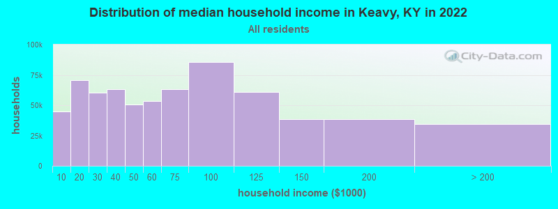
| Keavy: | $52,828 |
| KY: | $59,341 |
Estimated per capita income in 2022: $25,546 (it was $13,303 in 2000)
Keavy CCD income, earnings, and wages data
Estimated median house or condo value in 2022: $160,374 (it was $65,600 in 2000)
| Keavy: | $160,374 |
| KY: | $196,300 |
Detailed information about poverty and poor residents in Keavy, KY


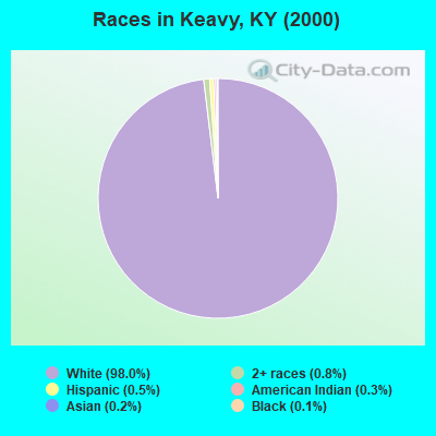
- 8,14598.0%White alone
- 670.8%Two or more races
- 400.5%Hispanic
- 290.3%American Indian alone
- 130.2%Asian alone
- 90.1%Black alone
- 40.05%Other race alone
Races in Keavy detailed stats: ancestries, foreign born residents, place of birth
According to our research of Kentucky and other state lists, there were 5 registered sex offenders living in Keavy, Kentucky as of April 19, 2024.
The ratio of all residents to sex offenders in Keavy is 1,798 to 1.
The ratio of registered sex offenders to all residents in this city is much lower than the state average.
 Recent articles from our blog. Our writers, many of them Ph.D. graduates or candidates, create easy-to-read articles on a wide variety of topics.

Current Local Time: EST time zone
Elevation: 1268 feet
Land area: 113.3 square miles.
Population density: 79 people per square mile (very low).

| Keavy CCD: | 0.5% ($352) |
| Kentucky: | 0.8% ($610) |
Nearest city with pop. 50,000+: Fayette, KY  (71.6 miles , pop. 260,512).
Nearest city with pop. 1,000,000+: Chicago, IL (381.7 miles , pop. 2,896,016).
Nearest cities:
), ), )Latitude: 37.02 N, Longitude: 84.20 W
Area code commonly used in this area: 606

| Here: | 4.1% |
| Kentucky: | 3.8% |
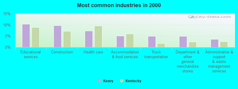
- Educational services (10.4%)
- Construction (9.7%)
- Health care (7.3%)
- Accommodation & food services (5.0%)
- Truck transportation (4.9%)
- Department & other general merchandise stores (4.9%)
- Administrative & support & waste management services (3.6%)
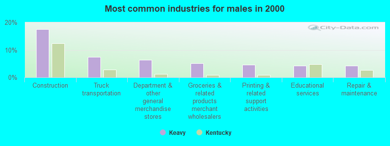
- Construction (17.4%)
- Truck transportation (7.5%)
- Department & other general merchandise stores (6.4%)
- Groceries & related products merchant wholesalers (5.2%)
- Printing & related support activities (4.7%)
- Educational services (4.2%)
- Repair & maintenance (4.2%)
- Educational services (17.3%)
- Health care (14.0%)
- Accommodation & food services (9.5%)
- Finance & insurance (6.0%)
- Administrative & support & waste management services (4.0%)
- Department & other general merchandise stores (3.2%)
- Food & beverage stores (3.0%)
- Driver/sales workers and truck drivers (5.9%)
- Other production occupations, including supervisors (5.7%)
- Other sales and related occupations, including supervisors (5.0%)
- Electrical equipment mechanics and other installation, maintenance, and repair workers, including supervisors (4.2%)
- Building and grounds cleaning and maintenance occupations (3.5%)
- Cashiers (3.4%)
- Other office and administrative support workers, including supervisors (3.3%)
- Driver/sales workers and truck drivers (10.7%)
- Electrical equipment mechanics and other installation, maintenance, and repair workers, including supervisors (7.9%)
- Other production occupations, including supervisors (6.6%)
- Other sales and related occupations, including supervisors (5.6%)
- Carpenters (4.1%)
- Metal workers and plastic workers (3.8%)
- Retail sales workers, except cashiers (3.7%)
- Other office and administrative support workers, including supervisors (7.0%)
- Cooks and food preparation workers (6.0%)
- Cashiers (5.6%)
- Information and record clerks, except customer service representatives (5.4%)
- Secretaries and administrative assistants (5.3%)
- Other teachers, instructors, education, training, and library occupations (5.1%)
- Other production occupations, including supervisors (4.6%)
Average climate in Keavy, Kentucky
Based on data reported by over 4,000 weather stations


(lower is better)
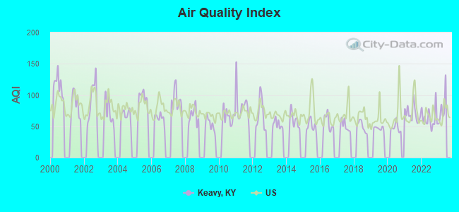
Air Quality Index (AQI) level in 2022 was 62.9. This is about average.
| City: | 62.9 |
| U.S.: | 72.6 |
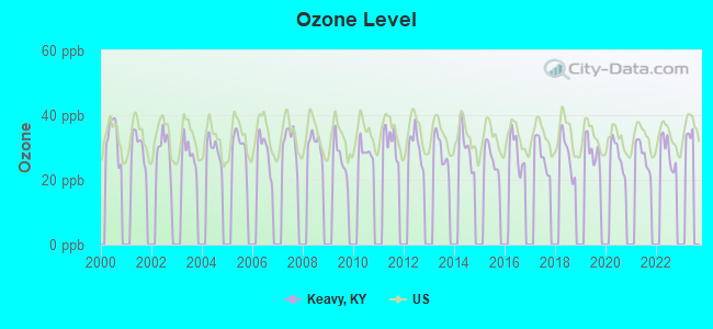
Ozone [ppb] level in 2022 was 28.6. This is about average. Closest monitor was 18.4 miles away from the city center.
| City: | 28.6 |
| U.S.: | 33.3 |
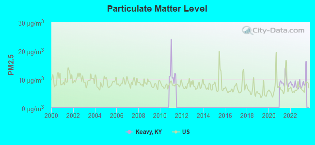
Particulate Matter (PM2.5) [µg/m3] level in 2022 was 7.87. This is about average. Closest monitor was 8.7 miles away from the city center.
| City: | 7.87 |
| U.S.: | 8.11 |
Tornado activity:
Keavy-area historical tornado activity is slightly below Kentucky state average. It is 9% smaller than the overall U.S. average.
On 4/3/1974, a category F4 (max. wind speeds 207-260 mph) tornado 26.3 miles away from the Keavy place center .
On 4/3/1974, a category F4 tornado 32.2 miles away from the place center killed 10 people and injured 113 people and caused between $5000 and $50,000 in damages.
Earthquake activity:
Keavy-area historical earthquake activity is significantly above Kentucky state average. It is 78% greater than the overall U.S. average.On 7/27/1980 at 18:52:21, a magnitude 5.2 (5.1 MB, 4.7 MS, 5.0 UK, 5.2 UK, Class: Moderate, Intensity: VI - VII) earthquake occurred 83.1 miles away from the city center
On 4/18/2008 at 09:36:59, a magnitude 5.4 (5.1 MB, 4.8 MS, 5.4 MW, 5.2 MW) earthquake occurred 224.7 miles away from Keavy center
On 11/30/1973 at 07:48:41, a magnitude 4.7 (4.7 MB, 4.6 ML, Class: Light, Intensity: IV - V) earthquake occurred 85.5 miles away from Keavy center
On 8/9/2020 at 12:07:37, a magnitude 5.1 (5.1 MW, Depth: 4.7 mi) earthquake occurred 176.1 miles away from the city center
On 9/7/1988 at 02:28:09, a magnitude 4.6 (4.5 MB, 4.6 LG) earthquake occurred 79.6 miles away from Keavy center
On 4/18/2008 at 09:36:59, a magnitude 5.2 (5.2 MW, Depth: 8.9 mi) earthquake occurred 224.7 miles away from Keavy center
Magnitude types: regional Lg-wave magnitude (LG), body-wave magnitude (MB), local magnitude (ML), surface-wave magnitude (MS), moment magnitude (MW)
Natural disasters:
The number of natural disasters in Laurel County (17) is near the US average (15).Major Disasters (Presidential) Declared: 11
Emergencies Declared: 2
Causes of natural disasters: Floods: 7, Storms: 7, Tornadoes: 6, Winds: 3, Fires: 2, Mudslides: 2, Snows: 2, Winter Storms: 2, Blizzard: 1, Freeze: 1, Hurricane: 1, Landslide: 1, Snowfall: 1, Other: 1 (Note: some incidents may be assigned to more than one category).
Hospitals and medical centers near Keavy:
- PROFESSIONAL HOME HEALTH CARE, INC (Home Health Center, about 3 miles away; LONDON, KY)
- CHRISTIAN HEALTH CENTER (Nursing Home, about 8 miles away; CORBIN, KY)
- CORBIN HEALTH AND REHABILITATION CENTER (Nursing Home, about 9 miles away; CORBIN, KY)
- THE HERITAGE (Nursing Home, about 9 miles away; CORBIN, KY)
- LONDON DIALYSIS CLINIC (Dialysis Facility, about 11 miles away; LONDON, KY)
- SETON HOME HEALTH SERVICES (Home Health Center, about 13 miles away; LONDON, KY)
Colleges/universities with over 2000 students nearest to Keavy:
- University of the Cumberlands (about 20 miles; Williamsburg, KY; Full-time enrollment: 3,585)
- Somerset Community College (about 24 miles; Somerset, KY; FT enrollment: 4,698)
- Lincoln Memorial University (about 43 miles; Harrogate, TN; FT enrollment: 3,706)
- Eastern Kentucky University (about 51 miles; Richmond, KY; FT enrollment: 13,525)
- Hazard Community and Technical College (about 59 miles; Hazard, KY; FT enrollment: 2,087)
- Lindsey Wilson College (about 62 miles; Columbia, KY; FT enrollment: 2,552)
- Southeast Kentucky Community and Technical College (about 67 miles; Cumberland, KY; FT enrollment: 2,196)
Public elementary/middle school in Keavy:
- KEAVY ELEMENTARY SCHOOL (Students: 353, Location: 598 W HWY 312, Grades: PK-5)
Points of interest:
Notable locations in Keavy: Auger Springs Picnic Area (A), Flat Woods Boat Ramp (B), Twin Branch Shelter Campground (C), Rockcastle Boat Ramp (D), Craig Creek Campground (E), Craig Creek Boat Ramp (F), Holly Bay Boat Ramp (G), Baldrock Conservation Center (H), Bee Rock Campground (I), Bee Rock Ramp (J), Bunch (K), Holly Bay Marina (L), Holly Bay Recreation Area (M), London Dock Marina (N), Rockcastle Campground (O), Bald Rock Picnic Area (P), White Oak Boat-in Camp (Q), White Oak Campground (R), Keavy Fire Department Station 2 (S), Bald Rock Volunteer Fire Department (T). Display/hide their locations on the map
Churches in Keavy include: Bethel Church (A), Antioch Church (B), Baldrock Church (C), Sublimity Church (D), Pleasant View Church (E), Pine Hill United Baptist Church (F), New Hope Church (G), Mount Zion Church (H), Moores Chapel (I). Display/hide their locations on the map
Cemeteries: Bald Rock Cemetery (1), Locust Grove Cemetery (2), Floyd Cemetery (3), Pleasant View Cemetery (4), Early Cemetery (5), Ward Cemetery (6), Sparks Cemetery (7). Display/hide their locations on the map
Reservoir: Laurel River Lake (A). Display/hide its location on the map
Streams, rivers, and creeks: Cane Branch (A), Cane Creek (B), Clifty Branch (C), Conoe Creek (D), Craig Creek (E), Daylight Branch (F), Doan Branch (G), Dutch Branch (H), Frozen Camp Creek (I). Display/hide their locations on the map
Parks in Keavy include: Cane Creek Wildlife Management Area (1), Dutch Branch Overlook (2). Display/hide their locations on the map
| This place: | 2.6 people |
| Kentucky: | 2.5 people |
| This place: | 74.1% |
| Whole state: | 66.9% |
| This place: | 5.8% |
| Whole state: | 6.4% |
Likely homosexual households (counted as self-reported same-sex unmarried-partner households)
- Lesbian couples: 0.3% of all households
- Gay men: 0.3% of all households
| This place: | 20.1% |
| Whole state: | 15.8% |
| This place: | 8.6% |
| Whole state: | 6.6% |
For population 15 years and over in Keavy:
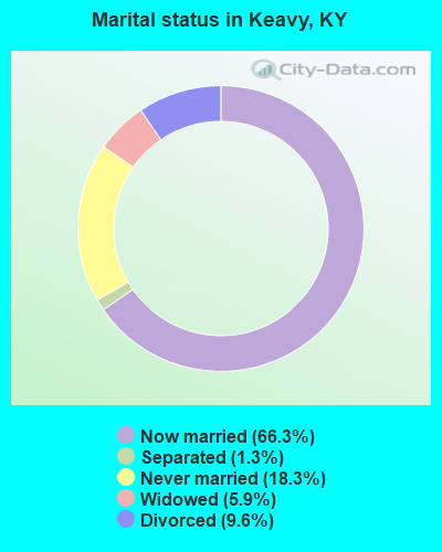
- Never married: 18.3%
- Now married: 66.3%
- Separated: 1.3%
- Widowed: 5.9%
- Divorced: 9.6%
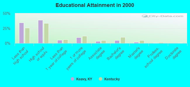
For population 25 years and over in Keavy:
- High school or higher: 65.3%
- Bachelor's degree or higher: 7.9%
- Graduate or professional degree: 2.9%
- Unemployed: 6.1%
- Mean travel time to work (commute): 22.5 minutes
| Here: | 13.7 |
| Kentucky average: | 13.8 |
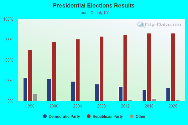
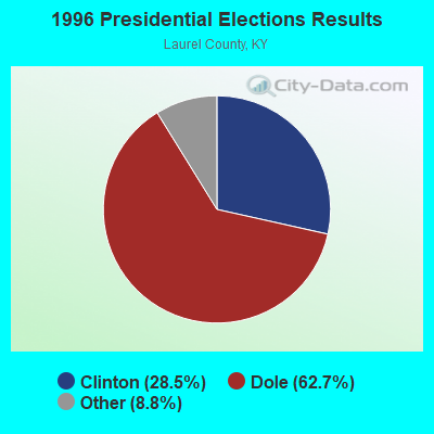
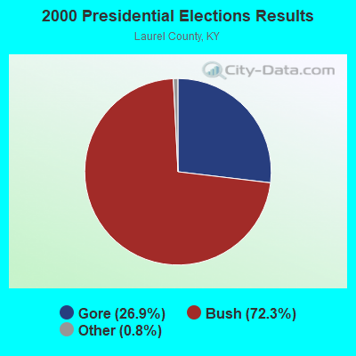
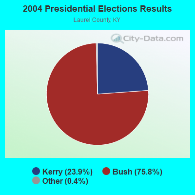
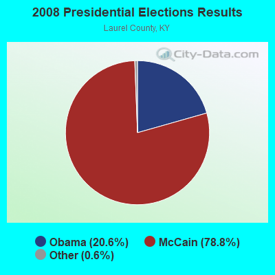
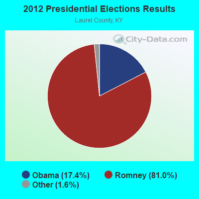

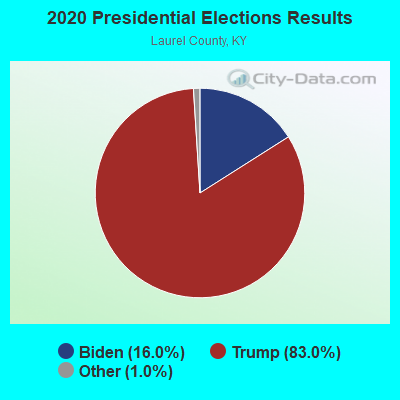
Graphs represent county-level data. Detailed 2008 Election Results
Religion statistics for Keavy, KY (based on Laurel County data)
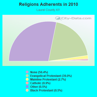
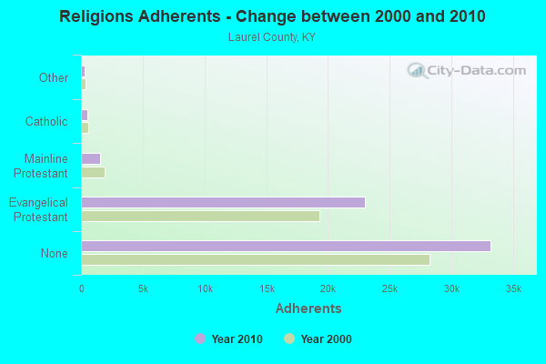
| Religion | Adherents | Congregations |
|---|---|---|
| Evangelical Protestant | 22,963 | 80 |
| Mainline Protestant | 1,579 | 8 |
| Catholic | 512 | 1 |
| Other | 309 | 2 |
| Black Protestant | 290 | 2 |
| None | 33,196 | - |
Food Environment Statistics:
| This county: | 2.79 / 10,000 pop. |
| State: | 2.19 / 10,000 pop. |
| Laurel County: | 0.35 / 10,000 pop. |
| Kentucky: | 0.25 / 10,000 pop. |
| This county: | 0.17 / 10,000 pop. |
| State: | 0.74 / 10,000 pop. |
| Laurel County: | 5.06 / 10,000 pop. |
| Kentucky: | 4.36 / 10,000 pop. |
| This county: | 5.23 / 10,000 pop. |
| Kentucky: | 5.74 / 10,000 pop. |
| Here: | 13.0% |
| State: | 11.0% |
| Laurel County: | 35.1% |
| State: | 30.0% |
| Laurel County: | 18.5% |
| State: | 15.9% |
Strongest AM radio stations in Keavy:
- WKDP (1330 AM; 5 kW; CORBIN, KY; Owner: EUBANKS BROADCASTING, INC.)
- WEKC (710 AM; daytime; 4 kW; WILLIAMSBURG, KY; Owner: GERALD PARKS)
- WKVL (850 AM; daytime; 50 kW; KNOXVILLE, TN; Owner: HORNE RADIO, LLC)
- WCTT (680 AM; 1 kW; CORBIN, KY; Owner: ENCORE COMMUNICATIONS, INC)
- WGWM (980 AM; 1 kW; LONDON, KY; Owner: WGWM BROADCASTING, INC.)
- WKLB (1290 AM; 5 kW; MANCHESTER, KY; Owner: BARKER BROADCASTING COMPANY, INC.)
- WFTG (1400 AM; 1 kW; LONDON, KY; Owner: F.T.G. BROADCASTING, INC.)
- WHAS (840 AM; 50 kW; LOUISVILLE, KY; Owner: CLEAR CHANNEL BROADCASTING LICENSES, INC.)
- WEZJ (1440 AM; 2 kW; WILLIAMSBURG, KY; Owner: WHITLEY BROADCASTING CO., INC.)
- WMIK (560 AM; 2 kW; MIDDLESBORO, KY; Owner: GATEWAY BROADCASTING, INC.)
- WSM (650 AM; 50 kW; NASHVILLE, TN; Owner: GAYLORD ENTERTAINMENT COMPANY)
- WLW (700 AM; 50 kW; CINCINNATI, OH; Owner: JACOR BROADCASTING CORPORATION)
- WFGW (1010 AM; 50 kW; BLACK MOUNTAIN, NC; Owner: BLUE RIDGE BROADCASTING CORP.)
Strongest FM radio stations in Keavy:
- WVCT (91.5 FM; KEAVY, KY; Owner: VICTORY TRAINING SCHOOL CORP.)
- WYGE (92.3 FM; LONDON, KY; Owner: ETHEL HUFF BROADCASTING, LLC)
- WKDP-FM (99.5 FM; CORBIN, KY; Owner: EUBANKS BROADCASTING, INC.)
- WCTT-FM (107.3 FM; CORBIN, KY; Owner: ENCORE COMMUNICATIONS, INC.)
- WEKX (102.7 FM; JELLICO, TN; Owner: WHITLEY BROADCASTING CO., INC.)
- WWEL (103.9 FM; LONDON, KY; Owner: F.T.G. BROADCASTING, INC.)
- WEZJ-FM (104.3 FM; WILLIAMSBURG, KY; Owner: WHITLEY BROADCASTING CO., INC.)
- WMIK-FM (92.7 FM; MIDDLESBORO, KY; Owner: GATEWAY BROADCASTING, INC.)
- WLLK (93.9 FM; BURNSIDE, KY; Owner: CAPSTAR TX LIMITED PARTNERSHIP)
- WTHL (90.5 FM; SOMERSET, KY; Owner: SOMERSET EDUCATIONAL BROADCASTING FOUNDATION)
- WSEK (97.1 FM; SOMERSET, KY; Owner: CAPSTAR TX LIMITED PARTNERSHIP)
- WTBK (105.7 FM; MANCHESTER, KY; Owner: MANCHESTER COMMUNICATIONS, INC.)
- WWLT (103.1 FM; MANCHESTER, KY; Owner: VERNON R. BALDWIN, INC.)
- WDVX (89.9 FM; CLINTON, TN; Owner: CUMBERLAND COMMUNITIES COMMUNI CORP.)
- WRIL (106.3 FM; PINEVILLE, KY; Owner: PINE HILLS BROADCASTING, INC.)
- WKKQ (96.1 FM; BARBOURVILLE, KY; Owner: BARBOURVILLE COMMUNITY B/NG CO.INC.)
- WLFX (106.7 FM; BEREA, KY; Owner: WALLINGFORD COMMUNICATIONS, LLC)
- WHAY (105.9 FM; WHITLEY CITY, KY; Owner: TIM LAVENDER)
- W277AA (103.3 FM; SOMERSET, KY; Owner: WESTERN KENTUCKY UNIVERSITY)
TV broadcast stations around Keavy:
- WVTN-LP (Channel 48; CORBIN, KY; Owner: VICTORY TRAINING SCHOOL CORP.)
- W39CK (Channel 20; CORBIN, KY; Owner: DEREK RAY EUBANKS)
- WOBZ-LP (Channel 9; EAST BERNSTADT, ETC., KY; Owner: ANDREA JOY KESLER)
- WKSO-TV (Channel 29; SOMERSET, KY; Owner: KENTUCKY AUTHORITY FOR EDUCATIONAL TV)
- W33BK (Channel 33; CORBIN, KY; Owner: TRINITY BROADCASTING NETWORK)
FCC Registered Antenna Towers:
1- 968 West City Dam Road (Lat: 36.983611 Lon: -84.133611), Type: 107.6, Overall height: 106.7 m, Registrant: Victory Training School Corp., Keavy, Phone: (606) 528-4671
FCC Registered Private Land Mobile Towers:
3- 4.8 Km Se Of West City Dam Rd (Lat: 36.972583 Lon: -84.124389), Type: Tower, Structure height: 108 m, Call Sign: WPKI513,
Assigned Frequencies: 929.712 MHz, Grant Date: 02/28/1997, Expiration Date: 02/28/2007, Cancellation Date: 03/27/2001, Certifier: Charles Sadler, Registrant: O Connor & Hannan LLP, 1919 Pennsylvania Ave Nw Ste 800, Washington, DC 20006, Fax: (202) 466-2198
- 4.8 Km Se Of West City Dam Rd (Lat: 36.972583 Lon: -84.124389), Type: Tower, Structure height: 108 m, Call Sign: WPKI514,
Assigned Frequencies: 929.662 MHz, Grant Date: 02/28/1997, Expiration Date: 02/28/2007, Cancellation Date: 03/27/2001, Certifier: Charles Sadler, Registrant: O Connor & Hannan LLP, 1919 Pennsylvania Ave Nw Ste 800, Washington, DC 20006, Fax: (202) 466-2198
- 4.8 Km Se Of West City Dam Rd (Lat: 36.972583 Lon: -84.124389), Type: Tower, Structure height: 108 m, Call Sign: WPKL973,
Assigned Frequencies: 929.762 MHz, Grant Date: 04/14/1997, Expiration Date: 04/14/2007, Cancellation Date: 11/10/2004, Certifier: Stan F Sech, Registrant: Venable LLP, 575 7th Street Nw, Washington, DC 20004, Phone: (202) 344-4653, Fax: (202) 344-8300, Email:
FCC Registered Broadcast Land Mobile Towers:
1- ICCLL-INTAKE, Craig Creeks Road (Lat: 37.000667 Lon: -84.201778), Type: Building, Structure height: 4.2 m, Overall height: 13.9 m, Call Sign: KNCY664,
Assigned Frequencies: 173.275 MHz, Grant Date: 02/10/2022, Expiration Date: 03/17/2032, Registrant: Business Radio Licensing, 30251 Golden Lantern, Suite E #501, Laguna Niguel, CA 92677, Phone: (949) 348-8510, Fax: (949) 348-8514, Email:
FCC Registered Microwave Towers:
4- Laurel County Switch, .6 Miles At 100degrees From Keavy, Ky (Lat: 36.996611 Lon: -84.158000), Type: Tower, Structure height: 54.9 m, Overall height: 57.9 m, Call Sign: WPVN686,
Assigned Frequencies: 952.243 MHz, 928.243 MHz, Grant Date: 06/18/2022, Expiration Date: 07/22/2032, Certifier: Donald R Schaefer, Registrant: Utility Telecom Consulting Group, 1554 Saint Paul Street, Denver, CO 80206, Phone: (303) 840-2878, Fax: (303) 840-1028, Email:
- LAUREL CNTY, .5 Mi E Of (Lat: 36.996611 Lon: -84.158000), Type: Gtower, Structure height: 54.9 m, Call Sign: WPWK597,
Assigned Frequencies: 6635.00 MHz, 6635.00 MHz, 6635.00 MHz, 6635.00 MHz, 6635.00 MHz, Grant Date: 11/23/2022, Expiration Date: 12/09/2032, Certifier: Terry E Estes, Registrant: Utility Telecom Consulting Group, Inc., 9850 S Maryland Pkwy Ste A5-108, Las Vegas, NV 89183, Phone: (702) 340-1706, Email:
- Radio Station Tower, 968 West City Dam Road (Lat: 36.983611 Lon: -84.133611), Type: Ltower, Structure height: 106.7 m, Overall height: 107.6 m, Call Sign: WRVM779,
Assigned Frequencies: 10755.0 MHz, 10755.0 MHz, 11245.0 MHz, 11245.0 MHz, Grant Date: 12/12/2022, Expiration Date: 12/12/2032, Certifier: Daniel F Hyravy, Registrant: Intelpath, 145, Hinsdale, IL 60522, Phone: (312) 841-9188, Email:
- Laurel County Switchyard .6 Mi At 100 Deg From (Lat: 36.996611 Lon: -84.157972), Overall height: 54.9 m, Call Sign: WHC573,
Assigned Frequencies: 6585.00 MHz, 6695.00 MHz, 6605.00 MHz, Grant Date: 07/20/1998, Expiration Date: 07/20/2008, Cancellation Date: 04/04/2008, Phone: (606) 744-4812
FCC Registered Amateur Radio Licenses:
8 (See the full list of FCC Registered Amateur Radio Licenses in Keavy)FAA Registered Aircraft:
6- Aircraft: BELTRAM VICTOR R GLASAIR-TD (Category: Land, Seats: 2, Weight: Up to 12,499 Pounds), Engine: LYCOMING 0-320 SERIES (180 HP) (Reciprocating)
N-Number: 22VB, N22VB, N-22VB, Serial Number: 1050, Year manufactured: 1994, Airworthiness Date: 06/25/2003, Certificate Issue Date: 06/04/2002
Registrant (Individual): Tom Cooper, 1194 E Highway 552, Keavy, KY 40737 - Aircraft: METZ - ROYD SKY-STAR (Category: Land, Seats: 2, Weight: Up to 12,499 Pounds), Engine: BOMBARDIER ROTAX (ALL) (Reciprocating)
N-Number: 320FL, N320FL, N-320FL, Serial Number: LBS-088, Year manufactured: 1996, Airworthiness Date: 05/07/1996, Certificate Issue Date: 01/21/2014
Registrant (Individual): Thomas E Cooper, 1194 E Highway 552, Keavy, KY 40737 - Aircraft: COOPER TOM KITFOX IV (Category: Land, Seats: 2, Weight: Up to 12,499 Pounds), Engine: Reciprocating
N-Number: 46472, N46472, N-46472, Serial Number: 001, Certificate Issue Date: 07/21/2005
Registrant (Individual): Tom Cooper, 1194 E Highway 552, Keavy, KY 40737
Deregistered: Yes - Aircraft: KESSINGER ROGER L RANS COYOTE (Category: Land, Weight: Up to 12,499 Pounds), Engine: ROTAX 503 DCDI (52 HP) (2 Cycle)
N-Number: 910RK, N910RK, N-910RK, Serial Number: 296, Year manufactured: 2007, Airworthiness Date: 01/12/2008, Certificate Issue Date: 11/28/2018
Registrant (Individual): Tom Cooper, 183 Cooper Hill Ln, Keavy, KY 40737 - Aircraft: FETERL J/CHARLESTON LIONS CLUB KITFOX IV (Category: Land, Seats: 2, Weight: Up to 12,499 Pounds), Engine: BOMBARDIER ROTAX (ALL) (Reciprocating)
N-Number: 94JF, N94JF, N-94JF, Serial Number: 1812, Year manufactured: 1994, Airworthiness Date: 05/23/1994, Certificate Issue Date: 04/24/2013
Registrant (Individual): Tom E Cooper, 1194 E Highway 552, Keavy, KY 40737 - Aircraft: CHARLES G ADAMS KOLB FIRESTAR SS (Category: Land, Seats: 2, Weight: Up to 12,499 Pounds), Engine: 2 Cycle
N-Number: 1909A, N1909A, N-1909A, Serial Number: FS SS 13-4-00094, Certificate Issue Date: 08/28/2017
Registrant (Individual): Tom Cooper, 183 Cooper Hill Ln, Keavy, KY 40737
Deregistered: Cancel Date: 09/10/2009
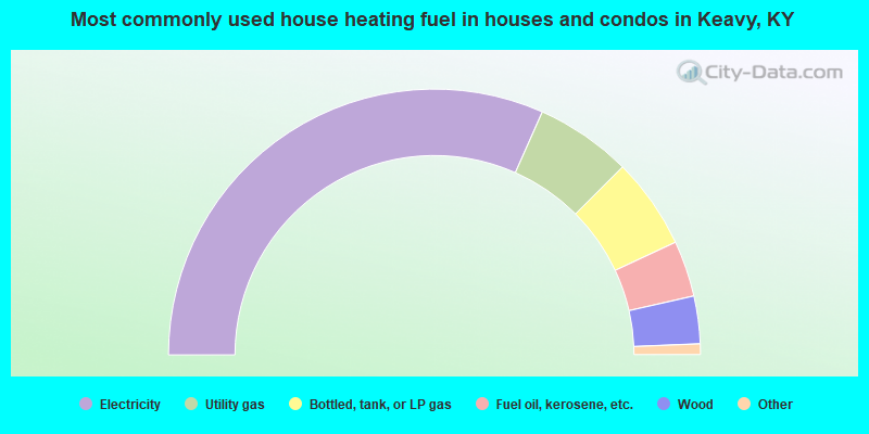
- 63.3%Electricity
- 11.7%Utility gas
- 11.1%Bottled, tank, or LP gas
- 6.8%Fuel oil, kerosene, etc.
- 5.8%Wood
- 0.6%Coal or coke
- 0.3%Other fuel
- 0.3%No fuel used
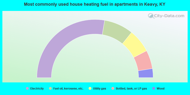
- 55.4%Electricity
- 16.3%Fuel oil, kerosene, etc.
- 13.1%Utility gas
- 10.3%Bottled, tank, or LP gas
- 5.0%Wood
Keavy compared to Kentucky state average:
- Unemployed percentage below state average.
- Black race population percentage significantly below state average.
- Hispanic race population percentage significantly below state average.
- Median age below state average.
- Foreign-born population percentage significantly below state average.
- Renting percentage below state average.
- Length of stay since moving in significantly above state average.
- Number of rooms per house significantly below state average.
- House age significantly below state average.
- Percentage of population with a bachelor's degree or higher significantly below state average.
Keavy on our top lists:
- #2 on the list of "Top 101 cities with largest percentage of males in occupations: printing workers (population 5,000+)"
- #4 on the list of "Top 101 cities with largest percentage of males in industries: printing and related support activities (population 5,000+)"
- #4 on the list of "Top 101 cities with largest percentage of males in industries: department and other general merchandise stores (population 5,000+)"
- #6 on the list of "Top 101 cities with largest percentage of males in industries: groceries and related products merchant wholesalers (population 5,000+)"
- #9 on the list of "Top 101 cities with largest percentage of males in occupations: food processing workers (population 5,000+)"
- #11 on the list of "Top 101 cities with largest percentage of females in industries: data processing, libraries, and other information services (population 5,000+)"
- #16 on the list of "Top 101 cities with largest percentage of males in industries: truck transportation (population 5,000+)"
- #16 on the list of "Top 101 cities with largest percentage of females in occupations: fishing and hunting, and forest and logging workers (population 5,000+)"
- #21 on the list of "Top 101 cities with largest percentage of females in industries: metals and minerals, except petroleum, merchant wholesalers (population 5,000+)"
- #23 on the list of "Top 101 cities with largest percentage of females in occupations: cooks and food preparation workers (population 5,000+)"
- #27 on the list of "Top 101 cities with largest percentage of males in occupations: driver/sales workers and truck drivers (population 5,000+)"
- #30 on the list of "Top 101 cities with largest percentage of females in industries: truck transportation (population 5,000+)"
- #33 on the list of "Top 100 least racially diverse cities (pop. 5,000+)"
- #34 on the list of "Top 101 cities with largest percentage of females in industries: beverage and tobacco products (population 5,000+)"
- #34 on the list of "Top 101 cities with largest percentage of females in occupations: other teachers and instructors, education, training, and library occupations (population 5,000+)"
- #45 on the list of "Top 101 cities with largest percentage of females in industries: nonmetallic mineral products (population 5,000+)"
- #46 on the list of "Top 101 cities with largest percentage of males in industries: food (population 5,000+)"
- #47 on the list of "Top 101 cities with largest percentage of females in industries: gasoline stations (population 5,000+)"
- #47 on the list of "Top 101 cities with largest percentage of females in industries: used merchandise, gift, novelty, and souvenir, and other miscellaneous stores (population 5,000+)"
- #51 on the list of "Top 101 cities with largest percentage of females in industries: music stores (population 5,000+)"
- #9 on the list of "Top 101 counties with highest percentage of residents voting for Romney (Republican) in the 2012 Presidential Election (pop. 50,000+)"
- #11 on the list of "Top 101 counties with the smallest number of children under 18 without health insurance coverage in 2000 (pop. 50,000+)"
- #75 on the list of "Top 101 counties with the smallest number of people without health insurance coverage in 2000"