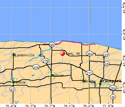
Kent, New York
Submit your own pictures of this town and show them to the world
- OSM Map
- General Map
- Google Map
- MSN Map
Population change since 2000: -3.6%
 |
| Males: 6,717 | |
| Females: 6,790 |
| Median resident age: | 42.8 years |
| New York median age: | 40.7 years |
Zip codes: 10512.
| Kent: | $111,205 |
| NY: | $79,557 |
Estimated per capita income in 2022: $53,859 (it was $29,984 in 2000)
Kent town income, earnings, and wages data
Estimated median house or condo value in 2022: $350,050 (it was $164,800 in 2000)
| Kent: | $350,050 |
| NY: | $400,400 |
Mean prices in 2022: all housing units: $511,003; detached houses: $544,773; townhouses or other attached units: $394,159; in 2-unit structures: $469,697; in 3-to-4-unit structures: $440,923; in 5-or-more-unit structures: $358,923; mobile homes: $103,512
Detailed information about poverty and poor residents in Kent, NY
Compare current foreclosures near Kent, NY:
| Photo | Address | Area | Beds / Baths | Price | Details |
|---|---|---|---|---|---|

|
#1
Carr Rd
Kent, NY 14477
|
1,353 sq. feet
|
1 baths 3 beds |
show details | |

|
#2
Ridge Rd W
Kent, NY 14477
|
3,214 sq. feet
|
2 baths 7 beds |
show details | |

|
#3
Tonetta Lake Rd
Brewster, NY 10509
|
2,383 sq. feet
|
2 baths 3 beds |
$174,900
|
show details |

|
#4
Patti Pl
Hopewell Junction, NY 12533
|
1,400 sq. feet
|
2 baths 3 beds |
$518,900
|
show details |

|
#5
Olcott Way # 122
Ridgefield, CT 06877
|
920 sq. feet
|
1 baths 1 beds |
$364,900
|
show details |

|
#6
N Brewster Rd
Brewster, NY 10509
|
3,424 sq. feet
|
2 baths 5 beds |
$325,000
|
show details |

|
#7
Chalmers Blvd
Amawalk, NY 10501
|
1,072 sq. feet
|
1 baths 1 beds |
$489,900
|
show details |

|
#8
Abbott Ave
Danbury, CT 06810
|
1,401 sq. feet
|
1 baths 3 beds |
$499,900
|
show details |

|
#9
Dorothy Hts
Wappingers Falls, NY 12590
|
1,113 sq. feet
|
1 baths 3 beds |
$389,900
|
show details |

|
#10
Highland Park Dr
Danbury, CT 06811
|
875 sq. feet
|
2 baths 2 beds |
$460,000
|
show details |
| Photo | Address | Area | Beds / Baths | Price | Details |
|---|---|---|---|---|---|

|
#11
Drew Ave
Highland Falls, NY 10928
|
1,724 sq. feet
|
2 baths 4 beds |
show details | |

|
#12
Wooster St
Bethel, CT 06801
|
2,573 sq. feet
|
3 baths 5 beds |
show details | |

|
#13
Smith Rd
Poughkeepsie, NY 12603
|
2,100 sq. feet
|
3 baths 5 beds |
show details | |

|
#14
Friendly Rd
Mahopac, NY 10541
|
1,808 sq. feet
|
1 baths 4 beds |
show details | |

|
#15
Cooper Rd
Fishkill, NY 12524
|
1,346 sq. feet
|
2 baths 2 beds |
show details | |

|
#16
Starview Ave
Putnam Valley, NY 10579
|
1,952 sq. feet
|
2 baths 2 beds |
show details | |

|
#17
Hamilton Rd
Hopewell Junction, NY 12533
|
2,468 sq. feet
|
3 baths 4 beds |
show details | |

|
#18
Route 376
Wappingers Falls, NY 12590
|
1,894 sq. feet
|
1 baths 3 beds |
show details | |

|
#19
Acorn Ct
Wappingers Falls, NY 12590
|
2,821 sq. feet
|
2 baths 4 beds |
show details | |

|
#20
Edge Hill Rd
Wappingers Falls, NY 12590
|
3,263 sq. feet
|
3 baths 3 beds |
show details |
| Photo | Address | Area | Beds / Baths | Price | Details |
|---|---|---|---|---|---|

|
#21
Huntington Ct
Bethel, CT 06801
|
1,312 sq. feet
|
1 baths 2 beds |
show details | |

|
#22
Miller Hill Rd
Carmel, NY 10512
|
816 sq. feet
|
1 baths 1 beds |
show details | |

|
#23
Grape Hollow Rd
Holmes, NY 12531
|
3,972 sq. feet
|
3 baths 6 beds |
show details | |

|
#24
Honness Rd
Fishkill, NY 12524
|
3,292 sq. feet
|
2 baths 3 beds |
show details | |

|
#25
Stowe Rd
Peekskill, NY 10566
|
- sq. feet
|
2 baths 4 beds |
show details | |

|
#26
Dunham Ct
Hopewell Junction, NY 12533
|
3,151 sq. feet
|
2 baths 4 beds |
show details | |

|
#27
Great Plain Road15
Danbury, CT 06811
|
715 sq. feet
|
1 baths 1 beds |
show details | |

|
#28
Purse Ln # 12533
Hopewell Junction, NY 12533
|
910 sq. feet
|
1 baths 2 beds |
show details | |

|
#29
Oak Crest Dr
Brookfield, CT 06804
|
2,074 sq. feet
|
1 baths 3 beds |
show details | |

|
#30
Chestnut Ridge Rd
Dover Plains, NY 12522
|
1,002 sq. feet
|
1 baths 2 beds |
show details |
| Photo | Address | Area | Beds / Baths | Price | Details |
|---|---|---|---|---|---|

|
#31
Jessen Pl
Beacon, NY 12508
|
1,934 sq. feet
|
2 baths 4 beds |
show details | |

|
#32
All Angels Hill Rd
Wappingers Falls, NY 12590
|
1,196 sq. feet
|
2 baths 3 beds |
show details | |

|
#33
Walnut Dr
Mahopac, NY 10541
|
2,284 sq. feet
|
2 baths 4 beds |
show details | |

|
#34
Farmers Mills Rd
Carmel, NY 10512
|
2,067 sq. feet
|
2 baths 3 beds |
show details | |

|
#35
Fox Run Ln
Carmel, NY 10512
|
706 sq. feet
|
1 baths 1 beds |
show details | |

|
#36
Pray Ln
Lagrangeville, NY 12540
|
5,408 sq. feet
|
3 baths 4 beds |
show details | |

|
#37
Cumberland Rd
Fishkill, NY 12524
|
2,630 sq. feet
|
3 baths 3 beds |
show details | |

|
#38
Wildflower Rdg
Poughkeepsie, NY 12603
|
3,854 sq. feet
|
3 baths 4 beds |
show details | |

|
#39
Echo Rd
Carmel, NY 10512
|
1,368 sq. feet
|
1 baths 3 beds |
show details | |

|
#40
Susan Dr
Poughquag, NY 12570
|
1,048 sq. feet
|
2 baths 3 beds |
show details |
| Photo | Address | Area | Beds / Baths | Price | Details |
|---|---|---|---|---|---|

|
#41
Sachson Pl
Wappingers Falls, NY 12590
|
1,758 sq. feet
|
1 baths 3 beds |
show details | |

|
#42
Carmen Hill Rd # 1
New Milford, CT 06776
|
1,238 sq. feet
|
3 baths 3 beds |
show details | |

|
#43
Old West Point Rd E
Garrison, NY 10524
|
2,222 sq. feet
|
2 baths 3 beds |
show details | |

|
#44
Red Schoolhouse Rd
Fishkill, NY 12524
|
1,465 sq. feet
|
1 baths 3 beds |
show details | |

|
#45
N Cross Rd
Lagrangeville, NY 12540
|
2,034 sq. feet
|
2 baths 3 beds |
show details | |

|
#46
Hillair Rd
Lake Peekskill, NY 10537
|
758 sq. feet
|
1 baths 2 beds |
show details | |

|
#47
Liberty St
Beacon, NY 12508
|
1,200 sq. feet
|
1 baths 3 beds |
show details | |

|
#48
Wynwood Dr
New Milford, CT 06776
|
1,189 sq. feet
|
2 baths 3 beds |
show details | |

|
#49
Lake Dr
Lake Peekskill, NY 10537
|
900 sq. feet
|
1 baths 4 beds |
show details | |

|
Check over 1 million property listings on Foreclosure.com!
|
browse all offers | |||

- 10,97981.3%White alone
- 1,75513.0%Hispanic
- 3082.3%Black alone
- 2451.8%Asian alone
- 1671.2%Two or more races
- 280.2%American Indian alone
- 230.2%Other race alone
- 20.01%Native Hawaiian and Other
Pacific Islander alone
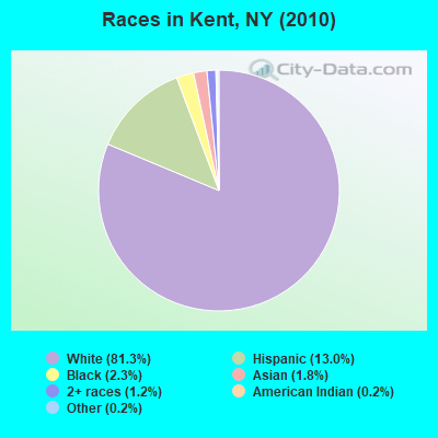
Races in Kent detailed stats: ancestries, foreign born residents, place of birth
According to our research of New York and other state lists, there was 1 registered sex offender living in Kent, New York as of April 25, 2024.
The ratio of all residents to sex offenders in Kent is 13,507 to 1.
The ratio of registered sex offenders to all residents in this city is much lower than the state average.
Type |
2009 |
2010 |
2011 |
2012 |
2013 |
2014 |
2015 |
2016 |
2017 |
2018 |
2019 |
2020 |
2022 |
|---|---|---|---|---|---|---|---|---|---|---|---|---|---|
| Murders (per 100,000) | 0 (0.0) | 0 (0.0) | 0 (0.0) | 0 (0.0) | 0 (0.0) | 0 (0.0) | 0 (0.0) | 0 (0.0) | 0 (0.0) | 0 (0.0) | 0 (0.0) | 0 (0.0) | 0 (0.0) |
| Rapes (per 100,000) | 1 (7.0) | 0 (0.0) | 0 (0.0) | 0 (0.0) | 1 (7.5) | 1 (7.5) | 2 (15.0) | 2 (15.1) | 1 (7.6) | 0 (0.0) | 4 (30.2) | 0 (0.0) | 3 (23.2) |
| Robberies (per 100,000) | 1 (7.0) | 1 (7.4) | 0 (0.0) | 0 (0.0) | 0 (0.0) | 1 (7.5) | 0 (0.0) | 0 (0.0) | 0 (0.0) | 0 (0.0) | 1 (7.6) | 1 (7.6) | 0 (0.0) |
| Assaults (per 100,000) | 2 (14.1) | 4 (29.6) | 1 (7.4) | 0 (0.0) | 0 (0.0) | 0 (0.0) | 0 (0.0) | 0 (0.0) | 0 (0.0) | 1 (7.5) | 0 (0.0) | 0 (0.0) | 1 (7.7) |
| Burglaries (per 100,000) | 21 (148.0) | 19 (140.7) | 26 (191.6) | 20 (147.0) | 22 (164.4) | 19 (141.8) | 7 (52.4) | 6 (45.2) | 9 (68.0) | 4 (30.0) | 2 (15.1) | 5 (38.1) | 5 (38.6) |
| Thefts (per 100,000) | 66 (465.1) | 66 (488.6) | 60 (442.2) | 71 (521.8) | 71 (530.6) | 61 (455.2) | 39 (291.8) | 47 (354.1) | 53 (400.3) | 45 (337.7) | 23 (173.8) | 29 (221.0) | 35 (270.4) |
| Auto thefts (per 100,000) | 1 (7.0) | 6 (44.4) | 2 (14.7) | 0 (0.0) | 5 (37.4) | 0 (0.0) | 0 (0.0) | 2 (15.1) | 0 (0.0) | 2 (15.0) | 2 (15.1) | 3 (22.9) | 0 (0.0) |
| Arson (per 100,000) | 0 (0.0) | 0 (0.0) | 0 (0.0) | 0 (0.0) | 0 (0.0) | 0 (0.0) | 1 (7.5) | 0 (0.0) | 1 (7.6) | 1 (7.5) | 1 (7.6) | 1 (7.6) | 0 (0.0) |
| City-Data.com crime index | 40.1 | 41.1 | 33.8 | 31.2 | 41.7 | 36.3 | 27.3 | 30.6 | 26.8 | 18.3 | 35.7 | 15.6 | 33.6 |
The City-Data.com crime index weighs serious crimes and violent crimes more heavily. Higher means more crime, U.S. average is 246.1. It adjusts for the number of visitors and daily workers commuting into cities.
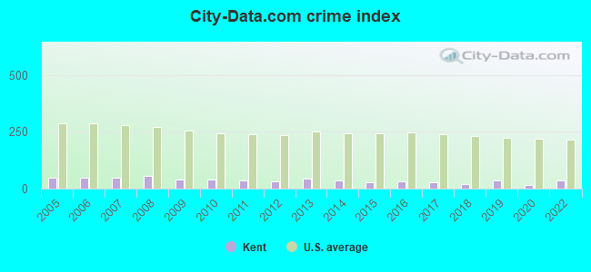
Crime rate in Kent detailed stats: murders, rapes, robberies, assaults, burglaries, thefts, arson
Full-time law enforcement employees in 2021, including police officers: 24 (19 officers - 17 male; 2 female).
| Officers per 1,000 residents here: | 1.45 |
| New York average: | 3.28 |
 Recent articles from our blog. Our writers, many of them Ph.D. graduates or candidates, create easy-to-read articles on a wide variety of topics.


Latest news from Kent, NY collected exclusively by city-data.com from local newspapers, TV, and radio stations
Ancestries: Irish (33.8%), Italian (31.3%), German (15.2%), English (7.0%), Polish (4.2%), United States (3.9%).
Current Local Time: EST time zone
Elevation: 340 feet
Land area: 40.6 square miles.
Population density: 332 people per square mile (very low).
882 residents are foreign born (4.1% Europe, 1.2% Asia, 0.9% Latin America).
| This town: | 6.3% |
| New York: | 20.4% |
| Kent town: | 3.0% ($4,901) |
| New York: | 1.9% ($2,847) |
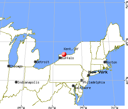
Nearest city with pop. 50,000+: Danbury, CT  (12.6 miles , pop. 74,848).
Nearest city with pop. 200,000+: Bronx, NY (44.1 miles , pop. 1,332,650).
Nearest cities:
), Latitude: 41.47 N, Longitude: 73.69 W
Area code commonly used in this area: 845

Kent, New York accommodation & food services, waste management - Economy and Business Data
Single-family new house construction building permits:
- 2022: 3 buildings, average cost: $227,500
- 2021: 2 buildings, average cost: $227,500
- 2016: 3 buildings, average cost: $263,300
- 2015: 3 buildings, average cost: $263,300
- 2014: 2 buildings, average cost: $230,000
- 2013: 5 buildings, average cost: $221,400
- 2012: 4 buildings, average cost: $219,500
- 2011: 4 buildings, average cost: $137,500
- 2010: 2 buildings, average cost: $107,500
- 2009: 3 buildings, average cost: $684,300
- 2008: 3 buildings, average cost: $184,700
- 2007: 11 buildings, average cost: $383,700
- 2006: 11 buildings, average cost: $227,800
- 2005: 11 buildings, average cost: $262,000
- 2004: 17 buildings, average cost: $345,200
- 2003: 29 buildings, average cost: $425,400
- 2002: 12 buildings, average cost: $185,500
- 2001: 26 buildings, average cost: $125,900
- 2000: 28 buildings, average cost: $125,700
- 1999: 32 buildings, average cost: $126,900
- 1998: 35 buildings, average cost: $120,100
- 1997: 18 buildings, average cost: $149,200
| Here: | 3.4% |
| New York: | 4.4% |
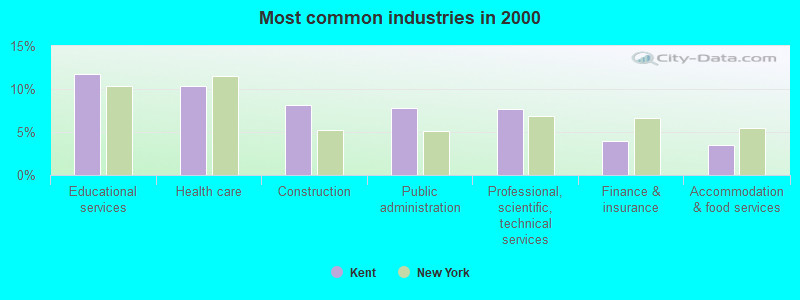
- Educational services (11.7%)
- Health care (10.4%)
- Construction (8.2%)
- Public administration (7.8%)
- Professional, scientific, technical services (7.7%)
- Finance & insurance (4.0%)
- Accommodation & food services (3.5%)
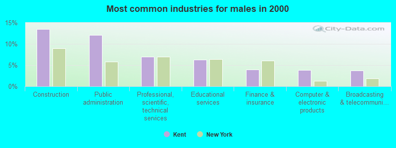
- Construction (13.4%)
- Public administration (12.1%)
- Professional, scientific, technical services (7.0%)
- Educational services (6.3%)
- Finance & insurance (3.9%)
- Computer & electronic products (3.8%)
- Broadcasting & telecommunications (3.7%)
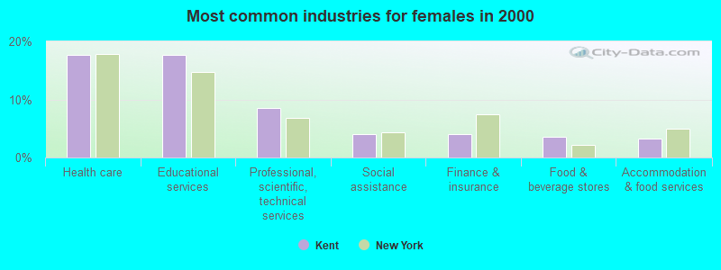
- Health care (17.7%)
- Educational services (17.6%)
- Professional, scientific, technical services (8.5%)
- Social assistance (4.1%)
- Finance & insurance (4.1%)
- Food & beverage stores (3.5%)
- Accommodation & food services (3.3%)
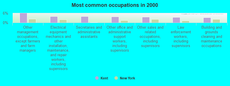
- Other management occupations, except farmers and farm managers (5.9%)
- Electrical equipment mechanics and other installation, maintenance, and repair workers, including supervisors (4.1%)
- Secretaries and administrative assistants (4.0%)
- Other office and administrative support workers, including supervisors (3.9%)
- Other sales and related occupations, including supervisors (3.7%)
- Law enforcement workers, including supervisors (3.4%)
- Building and grounds cleaning and maintenance occupations (3.4%)
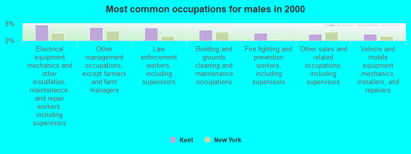
- Electrical equipment mechanics and other installation, maintenance, and repair workers, including supervisors (7.6%)
- Other management occupations, except farmers and farm managers (6.2%)
- Law enforcement workers, including supervisors (6.1%)
- Building and grounds cleaning and maintenance occupations (5.2%)
- Fire fighting and prevention workers, including supervisors (3.6%)
- Other sales and related occupations, including supervisors (3.1%)
- Vehicle and mobile equipment mechanics, installers, and repairers (3.1%)
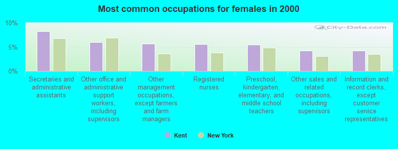
- Secretaries and administrative assistants (8.2%)
- Other office and administrative support workers, including supervisors (6.0%)
- Other management occupations, except farmers and farm managers (5.6%)
- Registered nurses (5.6%)
- Preschool, kindergarten, elementary, and middle school teachers (5.5%)
- Other sales and related occupations, including supervisors (4.2%)
- Information and record clerks, except customer service representatives (4.2%)
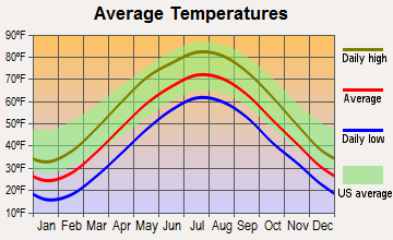
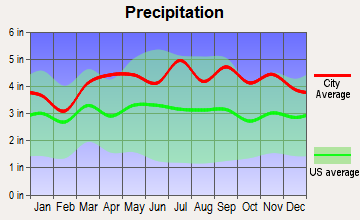
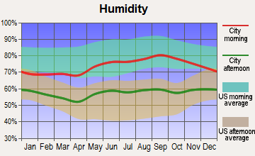
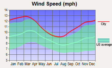
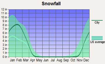
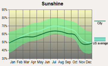
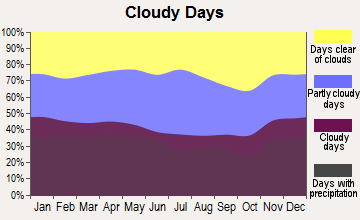
Average climate in Kent, New York
Based on data reported by over 4,000 weather stations
(lower is better)
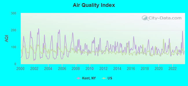
Air Quality Index (AQI) level in 2023 was 93.4. This is worse than average.
| City: | 93.4 |
| U.S.: | 72.6 |
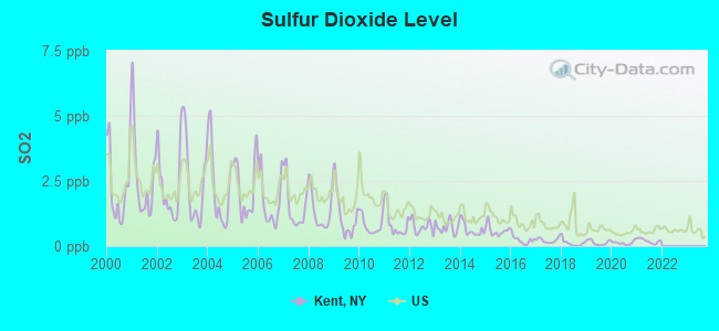
Sulfur Dioxide (SO2) [ppb] level in 2021 was 0.195. This is significantly better than average. Closest monitor was 1.4 miles away from the city center.
| City: | 0.195 |
| U.S.: | 1.515 |
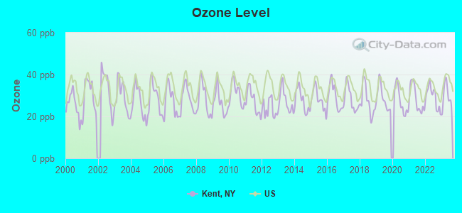
Ozone [ppb] level in 2023 was 29.7. This is about average. Closest monitor was 1.4 miles away from the city center.
| City: | 29.7 |
| U.S.: | 33.3 |
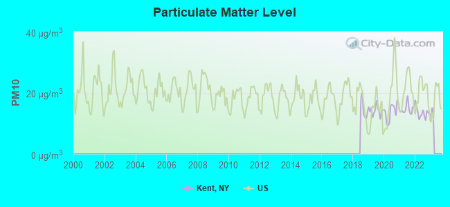
Particulate Matter (PM10) [µg/m3] level in 2022 was 13.5. This is significantly better than average. Closest monitor was 1.4 miles away from the city center.
| City: | 13.5 |
| U.S.: | 19.2 |
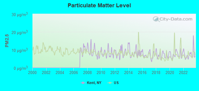
Particulate Matter (PM2.5) [µg/m3] level in 2023 was 8.34. This is about average. Closest monitor was 13.6 miles away from the city center.
| City: | 8.34 |
| U.S.: | 8.11 |
Tornado activity:
Kent-area historical tornado activity is above New York state average. It is 30% smaller than the overall U.S. average.
On 7/10/1989, a category F4 (max. wind speeds 207-260 mph) tornado 41.2 miles away from the Kent town center injured 40 people and caused between $50,000,000 and $500,000,000 in damages.
On 5/24/1962, a category F3 (max. wind speeds 158-206 mph) tornado 30.0 miles away from the town center killed one person and injured 50 people and caused between $500,000 and $5,000,000 in damages.
Earthquake activity:
Kent-area historical earthquake activity is significantly above New York state average. It is 69% smaller than the overall U.S. average.On 10/7/1983 at 10:18:46, a magnitude 5.3 (5.1 MB, 5.3 LG, 5.1 ML, Class: Moderate, Intensity: VI - VII) earthquake occurred 175.0 miles away from Kent center
On 4/20/2002 at 10:50:47, a magnitude 5.3 (5.3 ML, Depth: 3.0 mi) earthquake occurred 210.6 miles away from the city center
On 4/20/2002 at 10:50:47, a magnitude 5.2 (5.2 MB, 4.2 MS, 5.2 MW, 5.0 MW) earthquake occurred 208.8 miles away from Kent center
On 8/23/2011 at 17:51:04, a magnitude 5.8 (5.8 MW, Depth: 3.7 mi) earthquake occurred 334.1 miles away from Kent center
On 1/16/1994 at 01:49:16, a magnitude 4.6 (4.6 MB, 4.6 LG, Depth: 3.1 mi, Class: Light, Intensity: IV - V) earthquake occurred 145.9 miles away from the city center
On 1/19/1982 at 00:14:42, a magnitude 4.7 (4.5 MB, 4.7 MD, 4.5 LG) earthquake occurred 176.3 miles away from the city center
Magnitude types: regional Lg-wave magnitude (LG), body-wave magnitude (MB), duration magnitude (MD), local magnitude (ML), surface-wave magnitude (MS), moment magnitude (MW)
Natural disasters:
The number of natural disasters in Putnam County (22) is greater than the US average (15).Major Disasters (Presidential) Declared: 13
Emergencies Declared: 8
Causes of natural disasters: Hurricanes: 7, Floods: 5, Storms: 5, Blizzards: 2, Heavy Rain: 1, Landslide: 1, Power Outage: 1, Snowstorm: 1, Tropical Storm: 1, Water Shortage: 1, Winter Storm: 1, Other: 3 (Note: some incidents may be assigned to more than one category).
Hospitals and medical centers near Kent:
- PUTNAM NURSING AND REHABILITATION (Nursing Home, about 3 miles away; HOLMES, NY)
- PUTNAM CO DOH NURSNG SVCS CHHA (Home Health Center, about 5 miles away; BREWSTER, NY)
- CELIA DILL DIALYSIS CENTER (Dialysis Facility, about 7 miles away; CARMEL, NY)
- UCPA OF PUTNAM AND SOUTHERN DUTCHESS COUNTIES (Hospital, about 7 miles away; MAHOPAC, NY)
- PUTNAM HOSPITAL CENTER Acute Care Hospitals (about 8 miles away; CARMEL, NY)
- DUTCHESS CENTER FOR REHAB AND HEALTHCARE (Nursing Home, about 9 miles away; PAWLING, NY)
- OPENGATE, INC (Hospital, about 10 miles away; SOMERS, NY)
Operable nuclear power plants near Kent:
- 20 miles: Indian Point 2 and 3 in Buchanan, NY.
Colleges/universities with over 2000 students nearest to Kent:
- Western Connecticut State University (about 14 miles; Danbury, CT; Full-time enrollment: 5,345)
- United States Military Academy (about 15 miles; West Point, NY; FT enrollment: 5,651)
- Mount Saint Mary College (about 18 miles; Newburgh, NY; FT enrollment: 2,166)
- Vassar College (about 19 miles; Poughkeepsie, NY; FT enrollment: 2,469)
- Dutchess Community College (about 22 miles; Poughkeepsie, NY; FT enrollment: 6,554)
- Marist College (about 22 miles; Poughkeepsie, NY; FT enrollment: 5,536)
- Culinary Institute of America (about 23 miles; Hyde Park, NY; FT enrollment: 3,869)
Points of interest:
Notable locations in Kent: Gipsy Trail Club (A), Fahnestock Ski Slope (B), Sedgewood Club (C), Maynard Corners (D), Yale Corners (E), Clear Pool Camp (F), Camp Joy and Hope (G), Camp Hines (H), Foshay Corners (I), Westminster Camp (J), Kent Public Library (K). Display/hide their locations on the map
Churches in Kent include: Second Kent Baptist Church (A), Kent-Fishkill Baptist Church (B), Our Lady of the Lake Church (C). Display/hide their locations on the map
Cemeteries: Union Cemetery (1), Bailey Cemetery (2), Ballard Ground Cemetery (3), Kent Cliffs Baptist Church Burying Ground (4), Kent-Fishkill Baptist Church Cemetery (5), Ludingtonville Baptist Church Cemetery (6), Russell Mead Cemetery (7). Display/hide their locations on the map
Lakes, reservoirs, and swamps: John Pond (A), Little Buck Mountain Pond (B), Mill Pond (C), Lake Nimham (D), Palmer Lake (E), Pine Pond (F), Seven Hills Lake (G), Lake Tibet (H). Display/hide their locations on the map
Streams, rivers, and creeks: Trout Creek (A), Stump Pond Stream (B), Black Pond Brook (C), Bailey Brook (D), Leetown Brook (E), Horse Pound Brook (F). Display/hide their locations on the map
Birthplace of: Edwin Mortimer Hopkins - University professor and football coach.
| This town: | 2.7 people |
| New York: | 2.6 people |
| This town: | 76.1% |
| Whole state: | 63.5% |
| This town: | 5.5% |
| Whole state: | 6.8% |
Likely homosexual households (counted as self-reported same-sex unmarried-partner households)
- Lesbian couples: 0.5% of all households
- Gay men: 0.4% of all households
| This town: | 4.1% |
| Whole state: | 14.6% |
| This town: | 1.8% |
| Whole state: | 7.4% |
People in group quarters in Kent in 2010:
- 136 people in nursing facilities/skilled-nursing facilities
- 38 people in group homes intended for adults
- 21 people in other noninstitutional facilities
- 8 people in residential treatment centers for adults
People in group quarters in Kent in 2000:
- 147 people in nursing homes
- 31 people in homes for the mentally retarded
- 20 people in religious group quarters
- 4 people in other nonhousehold living situations
For population 15 years and over in Kent:
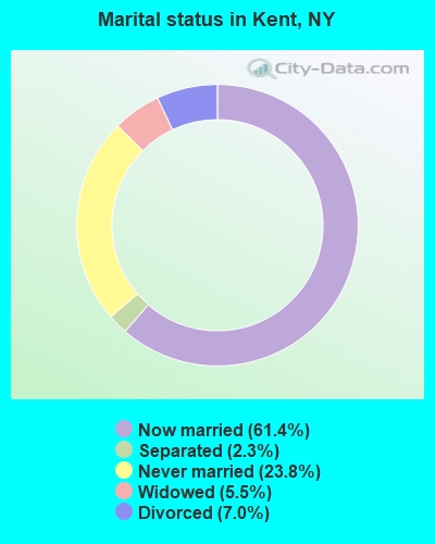
- Never married: 23.8%
- Now married: 61.4%
- Separated: 2.3%
- Widowed: 5.5%
- Divorced: 7.0%
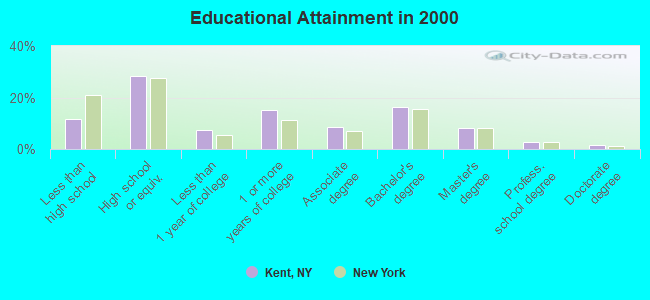
For population 25 years and over in Kent:
- High school or higher: 88.3%
- Bachelor's degree or higher: 28.8%
- Graduate or professional degree: 12.5%
- Unemployed: 2.6%
- Mean travel time to work (commute): 40.4 minutes
| Here: | 11.0 |
| New York average: | 14.2 |
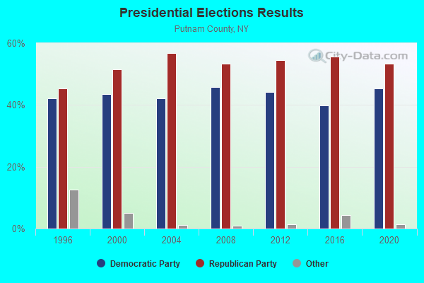
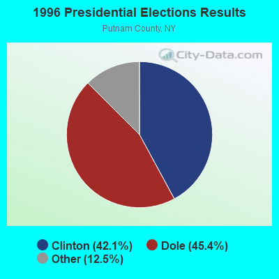
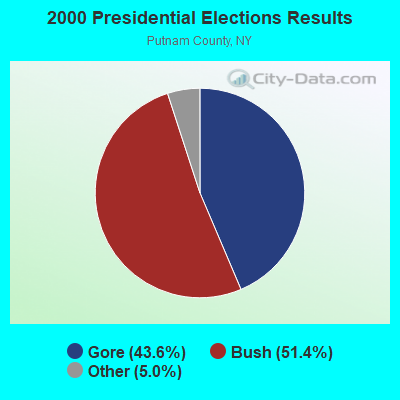
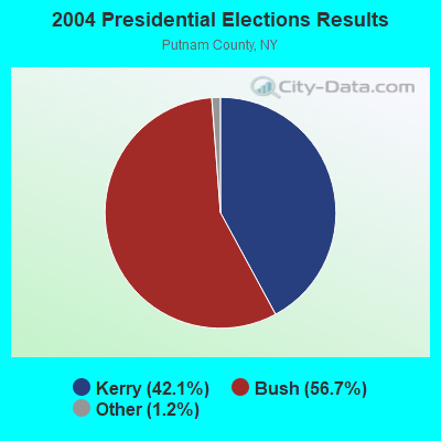
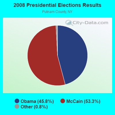
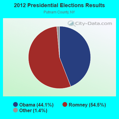
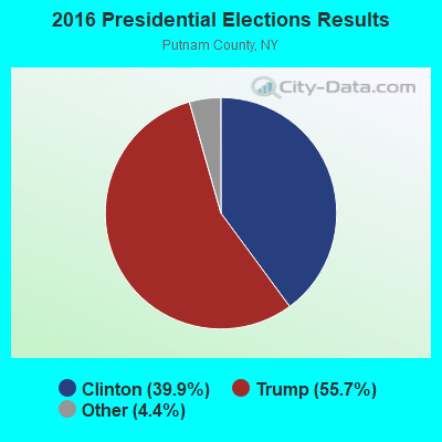
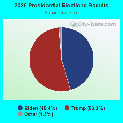
Graphs represent county-level data. Detailed 2008 Election Results
Religion statistics for Kent, NY (based on Putnam County data)
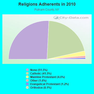
| Religion | Adherents | Congregations |
|---|---|---|
| Catholic | 41,420 | 9 |
| Mainline Protestant | 4,017 | 23 |
| Other | 1,588 | 7 |
| Evangelical Protestant | 1,208 | 14 |
| Orthodox | 145 | 2 |
| None | 51,332 | - |
Food Environment Statistics:
| Here: | 3.12 / 10,000 pop. |
| New York: | 4.13 / 10,000 pop. |
| Here: | 0.81 / 10,000 pop. |
| New York: | 0.92 / 10,000 pop. |
| This county: | 2.22 / 10,000 pop. |
| New York: | 1.68 / 10,000 pop. |
| Putnam County: | 8.77 / 10,000 pop. |
| New York: | 8.82 / 10,000 pop. |
| Putnam County: | 6.9% |
| State: | 8.2% |
| Here: | 24.3% |
| New York: | 23.8% |
| This county: | 22.7% |
| New York: | 15.6% |
Strongest AM radio stations in Kent:
- WFAN (660 AM; 50 kW; NEW YORK, NY; Owner: INFINITY BROADCASTING OPERATIONS, INC.)
- WCBS (880 AM; 50 kW; NEW YORK, NY; Owner: INFINITY BROADCASTING OPERATIONS, INC.)
- WABC (770 AM; 50 kW; NEW YORK, NY; Owner: WABC-AM RADIO, INC.)
- WMCA (570 AM; 50 kW; NEW YORK, NY; Owner: SALEM MEDIA OF NEW YORK, LLC)
- WOR (710 AM; 50 kW; NEW YORK, NY; Owner: BUCKLEY BROADCASTING CORPORATION)
- WPUT (1510 AM; daytime; 1 kW; BREWSTER, NY; Owner: CUMULUS LICENSING CORP.)
- WEPN (1050 AM; 50 kW; NEW YORK, NY; Owner: NEW YORK AM RADIO, LLC)
- WINS (1010 AM; 50 kW; NEW YORK, NY; Owner: INFINITY BROADCASTING OPERATIONS, INC.)
- WBBR (1130 AM; 50 kW; NEW YORK, NY; Owner: BLOOMBERG COMMUNICATIONS INC.)
- WTIC (1080 AM; 50 kW; HARTFORD, CT; Owner: INFINITY RADIO OPERATIONS INC.)
- WADO (1280 AM; 50 kW; NEW YORK, NY; Owner: WADO-AM LICENSE CORP.)
- WGNY (1220 AM; 10 kW; NEWBURGH, NY; Owner: SUNRISE BROADCASTING LLC)
- WGSM (740 AM; 25 kW; HUNTINGTON, NY; Owner: K RADIO LICENSEE, INC.)
Strongest FM radio stations in Kent:
- WDBY (105.5 FM; PATTERSON, NY; Owner: CUMULUS LICENSING CORP.)
- WSPK (104.7 FM; POUGHKEEPSIE, NY; Owner: 6 JOHNSON ROAD LICENSES, INC.)
- WRNQ (92.1 FM; POUGHKEEPSIE, NY; Owner: CLEAR CHANNEL BROADCASTING LICENSES, INC.)
- WPDH (101.5 FM; POUGHKEEPSIE, NY; Owner: CUMULUS LICENSING CORP.)
- WRKI (95.1 FM; BROOKFIELD, CT; Owner: CUMULUS LICENSING CORP.)
- WFNP (88.7 FM; ROSENDALE, NY; Owner: STATE UNIVERSITY OF NEW YORK)
- WRHV (88.7 FM; POUGHKEEPSIE, NY; Owner: WMHT EDUCATIONAL TELECOMMUNICATIONS)
- WDAQ (98.3 FM; DANBURY, CT; Owner: BERKSHIRE BROADCASTING CORP.)
- WCZX (97.7 FM; HYDE PARK, NY; Owner: CUMULUS LICENSING CORP.)
- WLJP (89.3 FM; MONROE, NY; Owner: SOUND OF LIFE, INC.)
- WBWZ (93.3 FM; NEW PALTZ, NY; Owner: CLEVELAND RADIO LICENSES, LLC)
- WRWD-FM (107.3 FM; HIGHLAND, NY; Owner: CLEVELAND RADIO LICENSES, LLC)
- WRRB (96.9 FM; ARLINGTON, NY; Owner: CUMULUS LICENSING CORP.)
- WHUD (100.7 FM; PEEKSKILL, NY; Owner: 6 JOHNSON ROAD LICENSES, INC.)
- W206AW (89.1 FM; PAWLING, NY; Owner: SOUND OF LIFE, INC.)
- WFKP (99.3 FM; ELLENVILLE, NY; Owner: CLEAR CHANNEL BROADCASTING LICENSES, INC.)
- WFAF (106.3 FM; MOUNT KISCO, NY; Owner: CUMULUS LICENSING CORP.)
- W292CM (106.3 FM; POUGHKEEPSIE, NY; Owner: JOHN KATONAH)
- WPLJ (95.5 FM; NEW YORK, NY; Owner: WPLJ-FM RADIO, INC.)
- WAMK (90.9 FM; KINGSTON, NY; Owner: W A M C)
TV broadcast stations around Kent:
- WTBY (Channel 54; POUGHKEEPSIE, NY; Owner: TRINITY BROADCASTING OF NEW YORK, INC.)
- WNYW (Channel 5; NEW YORK, NY; Owner: FOX TELEVISION STATIONS, INC.)
- WTIC-TV (Channel 61; HARTFORD, CT; Owner: TRIBUNE TELEVISION COMPANY)
- W11BJ (Channel 11; HARTFORD, CT; Owner: COMMUNICATIONS SITE MANAGEMENT LLC)
- WCBS-TV (Channel 2; NEW YORK, NY; Owner: CBS BROADCASTING INC.)
- WRNN-TV (Channel 62; KINGSTON, NY; Owner: WRNN-TV ASSOCIATES LIMITED PARTNERSHIP)
- WNJU (Channel 47; LINDEN, NJ; Owner: WNJU LICENSE CORPORATION)
- WFME-TV (Channel 66; WEST MILFORD, NJ; Owner: FAMILY STATIONS, INC.)
- WTXX (Channel 20; WATERBURY, CT; Owner: WTXX INC.)
- WPXN-TV (Channel 31; NEW YORK, NY; Owner: PAXSON COMMUNICATIONS LICENSE COMPANY, LLC)
- WXNY-LP (Channel 32; NEW YORK, NY; Owner: ISLAND BROADCASTING COMPANY)
- WFUT (Channel 68; NEWARK, NJ; Owner: UNIVISION NEW YORK LLC)
- WTNH (Channel 8; NEW HAVEN, CT; Owner: WTNH BROADCASTING, INC.)
- WCTX (Channel 59; NEW HAVEN, CT; Owner: WTNH BROADCASTING, INC.)
- WEDY (Channel 65; NEW HAVEN, CT; Owner: CONNECTICUT PUBLIC BROADCASTING, INC.)
- W68DN (Channel 68; CHERRY HILL, ETC., NJ; Owner: MARCIA COHEN)
- WEDW (Channel 49; BRIDGEPORT, CT; Owner: CONNECTICUT PUBLIC BROADCASTING, INC.)
- National Bridge Inventory (NBI) Statistics
- 21Number of bridges
- 118ft / 35.6mTotal length
- $31,015,000Total costs
- 213,146Total average daily traffic
- 20,331Total average daily truck traffic
- New bridges - historical statistics
- 41920-1929
- 31930-1939
- 21950-1959
- 111960-1969
- 11990-1999
FCC Registered Broadcast Land Mobile Towers:
2- Mount Ninham Road (Lat: 41.461194 Lon: -73.724583), Type: Ltower, Structure height: 24 m, Call Sign: KYQ563,
Assigned Frequencies: 153.935 MHz, Grant Date: 03/25/2024, Expiration Date: 03/31/2034, Certifier: Donald L Smith Jr, Registrant: Town Of Kent Police, 40 Sybils Crossing, Carmel, NY 10512, Phone: (845) 225-4600, Fax: (845) 306-5288, Email:
- BACKUP SITE, End Of Long Mountain Road - Radio Tower (Lat: 41.490083 Lon: -73.821528), Type: Ltower, Structure height: 30 m, Call Sign: WQXL767,
Assigned Frequencies: 453.500 MHz, Grant Date: 04/11/2016, Expiration Date: 04/11/2026, Certifier: Steven J Shultis, Registrant: Apco International, Inc., 351 N. Williamson Blvd., Daytona Beach, FL 32114, Phone: (386) 944-2469, Fax: (386) 322-2502, Email:
FCC Registered Microwave Towers:
2- MT NINHAM, Mt. Ninham Road (Lat: 41.461694 Lon: -73.726111), Type: Ltower, Structure height: 48.8 m, Call Sign: WQES593,
Assigned Frequencies: 10755.0 MHz, 10795.0 MHz, 957.950 MHz, 942.375 MHz, 959.150 MHz, Grant Date: 01/20/2016, Expiration Date: 04/04/2026, Certifier: Robert Mcmahon, Registrant: Putnam County Bureau Of Emergency Services, 112 Old Route 6 - Donald Smith Gov. Campus, Carmel, NY 10512, Phone: (845) 808-4000, Fax: (845) 808-4010
- Kent, No Exact Address (Lat: 43.342472 Lon: -78.136500), Type: Tank, Structure height: 42.7 m, Call Sign: WRWD401,
Assigned Frequencies: 11155.0 MHz, 11155.0 MHz, 11155.0 MHz, 11155.0 MHz, 11155.0 MHz, 11155.0 MHz, 11155.0 MHz, 11155.0 MHz, 11155.0 MHz, 11155.0 MHz, 11155.0 MHz, 11155.0 MHz, Grant Date: 02/08/2023, Expiration Date: 02/08/2033, Certifier: Steven Hubbard, Registrant: Intelpath, Hinsdale, IL 60522, Phone: (312) 841-9188, Email:
FCC Registered Maritime Coast & Aviation Ground Towers:
1- 988 Point Breeze Rd (Lat: 43.368667 Lon: -78.192806), Type: Building, Overall height: 5 m, Call Sign: KZA885,
Assigned Frequencies: 156.425 MHz, 156.800 MHz, 156.450 MHz, Grant Date: 08/25/1993, Expiration Date: 08/25/1998, Cancellation Date: 05/06/2001, Registrant: Four Seas Marina Inc, 14949 E County House Rd, Albion, NY 14411
FCC Registered Amateur Radio Licenses:
7- Call Sign: KB2MHA, Grant Date: 05/14/1991, Expiration Date: 05/14/2001, Cancellation Date: 05/15/2003, Registrant: Jeffery J Bateman, 14409 Lake Shore Rd, Kent, NY 14477
- Call Sign: KC2EOE, Licensee ID: L00339355, Grant Date: 01/08/1999, Expiration Date: 01/08/2009, Cancellation Date: 01/11/2011, Certifier: Amy L Folk, Registrant: Amy L Folk, 887 Transit Rd, Kent, NY 14477
- Call Sign: N2OAY, Grant Date: 10/01/1991, Expiration Date: 10/01/2001, Cancellation Date: 10/02/2003, Registrant: Henry W Costello, 15058 Rt 18, Kent, NY 14477
- Call Sign: KC2FVS, Licensee ID: L00193775, Grant Date: 01/11/2000, Expiration Date: 01/11/2010, Cancellation Date: 01/12/2012, Registrant: Paul N Folk, 887 Transit Rd, Kent, NY 14477
- Call Sign: KA2BBQ, Previous Call Sign: KC2UKX, Licensee ID: L01458292, Grant Date: 04/02/2019, Expiration Date: 05/27/2029, Certifier: Christopher A Provan, Registrant: Christopher A Provan, 29 Shenandoah Ct., Kent, NY 10512
- Call Sign: KE2ASN, Licensee ID: L02634792, Grant Date: 02/01/2023, Expiration Date: 02/01/2033, Certifier: Brian D Lonnen, Registrant: Brian D Lonnen, 14418 Baker Rd, Kent, NY 14477
- Call Sign: KE2BSF, Licensee ID: L02683884, Grant Date: 08/01/2023, Expiration Date: 08/01/2033, Certifier: Robert Cooper, Registrant: Robert K Cooper, 15016 Roosevelt Hwy, Kent, NY 14477
FAA Registered Aircraft:
1- Aircraft: CESSNA 182Q (Category: Land, Seats: 4, Weight: Up to 12,499 Pounds, Speed: 112 mph), Engine: CONT MOTOR O-470 SERIES (230 HP) (Reciprocating)
N-Number: 562SV, N562SV, N-562SV, Serial Number: 18266238, Year manufactured: 1978, Airworthiness Date: 02/24/1978, Certificate Issue Date: 03/18/2020
Registrant (LLC): Av8tr Holdings LLC, 14912 E Brighton Cliffe Dr, Kent, NY 14477
2002 - 2018 National Fire Incident Reporting System (NFIRS) incidents
- Fire incident types reported to NFIRS in Kent, NY
- 10557.4%Structure Fires
- 4826.2%Outside Fires
- 189.8%Other
- 126.6%Mobile Property/Vehicle Fires
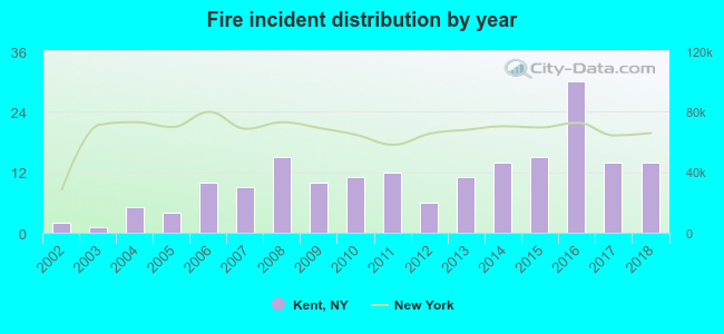 According to the data from the years 2002 - 2018 the average number of fire incidents per year is 11. The highest number of fire incidents - 30 took place in 2016, and the least - 1 in 2003. The data has a rising trend.
 When looking into fire subcategories, the most incidents belonged to: Structure Fires (57.4%), and Outside Fires (26.2%).
| Most common first names in Kent, NY among deceased individuals | ||
| Name | Count | Lived (average) |
|---|---|---|
| Mary | 14 | 75.6 years |
| William | 12 | 75.6 years |
| John | 11 | 69.8 years |
| Charles | 10 | 63.2 years |
| Robert | 10 | 68.0 years |
| Margaret | 6 | 79.8 years |
| James | 5 | 59.0 years |
| Arthur | 5 | 74.6 years |
| Ruth | 5 | 78.6 years |
| Walter | 5 | 72.0 years |
| Most common last names in Kent, NY among deceased individuals | ||
| Last name | Count | Lived (average) |
|---|---|---|
| Cliff | 5 | 79.2 years |
| Higley | 5 | 77.6 years |
| Nowicki | 5 | 73.0 years |
| Scharping | 5 | 72.0 years |
| Strickland | 5 | 79.0 years |
| Williams | 5 | 75.2 years |
| Jones | 4 | 73.5 years |
| Hardenbrook | 4 | 73.2 years |
| Thompson | 4 | 77.0 years |
| Bennett | 3 | 79.7 years |
- 75.9%Fuel oil, kerosene, etc.
- 18.3%Electricity
- 3.5%Bottled, tank, or LP gas
- 2.0%Wood
- 0.2%Other fuel
- 0.1%Coal or coke
- 60.4%Fuel oil, kerosene, etc.
- 27.0%Electricity
- 11.2%Bottled, tank, or LP gas
- 1.4%Utility gas
Kent compared to New York state average:
- Unemployed percentage significantly below state average.
- Black race population percentage significantly below state average.
- Foreign-born population percentage significantly below state average.
- Renting percentage significantly below state average.
- Length of stay since moving in significantly above state average.
- Number of rooms per house significantly below state average.
- House age significantly below state average.
Kent on our top lists:
- #43 on the list of "Top 101 cities with largest percentage of females in occupations: bus drivers (population 5,000+)"
- #54 on the list of "Top 101 cities with largest percentage of females in industries: publishing, and motion picture and sound recording industries (population 5,000+)"
- #56 on the list of "Top 101 cities with largest percentage of males in industries: broadcasting and telecommunications (population 5,000+)"
- #58 on the list of "Top 101 cities with largest percentage of males in industries: petroleum and petroleum products merchant wholesalers (population 5,000+)"
- #59 on the list of "Top 101 cities with largest percentage of females in industries: rail transportation (population 5,000+)"
- #68 on the list of "Top 101 cities with largest percentage of females in occupations: electricians (population 5,000+)"
- #70 on the list of "Top 101 cities with largest percentage of females in occupations: entertainers and performers, sports, and related workers (population 5,000+)"
- #82 on the list of "Top 100 cities with longest commuting times (pop. 5,000+)"
- #94 on the list of "Top 101 cities with largest percentage of females in occupations: counselors, social workers, and other community and social service specialists (population 5,000+)"
- #94 on the list of "Top 101 cities with largest percentage of females in occupations: lawyers (population 5,000+)"
- #98 on the list of "Top 101 cities with largest percentage of workers with very long commute times (90 or more minutes) (population 5,000+)"
- #50 on the list of "Top 101 counties with the highest surface withdrawal of fresh water for public supply"
- #51 on the list of "Top 101 counties with the lowest Ozone (1-hour) air pollution readings in 2012 (ppm)"
- #72 on the list of "Top 101 counties with the highest total withdrawal of fresh water for public supply"
- #89 on the list of "Top 101 counties with the lowest Sulfur Oxides Annual air pollution readings in 2012 (µg/m3)"

|
Total of 3 patent applications in 2008-2024.