Lambert, Montana
Submit your own pictures of this place and show them to the world
- OSM Map
- General Map
- Google Map
- MSN Map

| Males: 312 | |
| Females: 271 |
| Median resident age: | 36.4 years |
| Montana median age: | 37.5 years |
Zip code: 59243
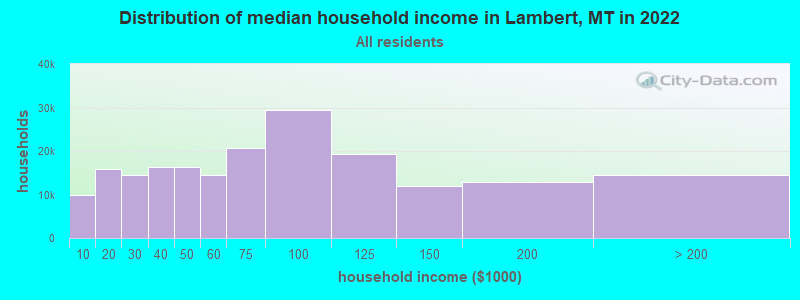
| Lambert: | $59,772 |
| MT: | $67,631 |
Estimated per capita income in 2022: $31,417 (it was $14,528 in 2000)
Lambert CCD income, earnings, and wages data
Estimated median house or condo value in 2022: $283,276 (it was $56,900 in 2000)
| Lambert: | $283,276 |
| MT: | $366,400 |
Detailed information about poverty and poor residents in Lambert, MT


- 60998.9%White alone
- 40.6%Hispanic
- 20.3%Two or more races
- 10.2%American Indian alone

Races in Lambert detailed stats: ancestries, foreign born residents, place of birth
According to our research of Montana and other state lists, there was 1 registered sex offender living in Lambert, Montana as of April 25, 2024.
The ratio of all residents to sex offenders in Lambert is 583 to 1.
The ratio of registered sex offenders to all residents in this city is lower than the state average.
 Recent articles from our blog. Our writers, many of them Ph.D. graduates or candidates, create easy-to-read articles on a wide variety of topics.

Current Local Time: MST time zone
Elevation: 2346 feet
Land area: 713.2 square miles.
Population density: 0.8 people per square mile (very low).

| Lambert CCD: | 0.8% ($438) |
| Montana: | 1.3% ($1,212) |
Nearest city with pop. 50,000+: Bismarck, ND  (195.6 miles , pop. 55,532).
Nearest city with pop. 200,000+: West Adams, CO (545.1 miles , pop. 259,628).
Nearest city with pop. 1,000,000+: Chicago, IL (927.9 miles , pop. 2,896,016).
Nearest cities:
), ), )Latitude: 47.75 N, Longitude: 104.71 W
Area code: 406

| Here: | 3.4% |
| Montana: | 3.8% |

- Agriculture, forestry, fishing & hunting (45.1%)
- Educational services (14.1%)
- Construction (4.4%)
- Health care (4.0%)
- Accommodation & food services (4.0%)
- Religious, grantmaking, civic, professional, similar organizations (3.4%)
- Truck transportation (3.0%)

- Agriculture, forestry, fishing & hunting (64.4%)
- Construction (7.2%)
- Truck transportation (5.0%)
- Educational services (3.3%)
- Food (2.8%)
- Farm product raw materials merchant wholesalers (2.2%)
- Motor vehicle & parts dealers (1.7%)

- Educational services (30.8%)
- Agriculture, forestry, fishing & hunting (15.4%)
- Accommodation & food services (10.3%)
- Health care (7.7%)
- Religious, grantmaking, civic, professional, similar organizations (6.0%)
- Professional, scientific, technical services (5.1%)
- Public administration (4.3%)

- Farmers and farm managers (29.6%)
- Agricultural workers, including supervisors (10.4%)
- Preschool, kindergarten, elementary, and middle school teachers (6.4%)
- Other management occupations, except farmers and farm managers (4.0%)
- Driver/sales workers and truck drivers (3.4%)
- Bus drivers (3.4%)
- Vehicle and mobile equipment mechanics, installers, and repairers (3.0%)

- Farmers and farm managers (45.0%)
- Agricultural workers, including supervisors (16.1%)
- Vehicle and mobile equipment mechanics, installers, and repairers (5.0%)
- Driver/sales workers and truck drivers (5.0%)
- Preschool, kindergarten, elementary, and middle school teachers (3.3%)
- Other sales and related occupations, including supervisors (2.8%)
- Metal workers and plastic workers (2.2%)

- Preschool, kindergarten, elementary, and middle school teachers (11.1%)
- Bus drivers (8.5%)
- Other management occupations, except farmers and farm managers (7.7%)
- Cooks and food preparation workers (6.8%)
- Bookkeeping, accounting, and auditing clerks (6.0%)
- Farmers and farm managers (6.0%)
- Secretaries and administrative assistants (6.0%)
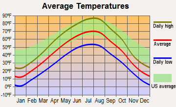
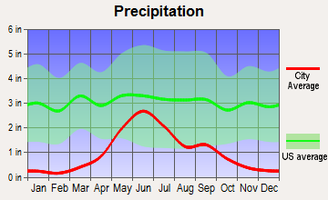
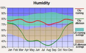
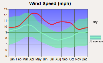
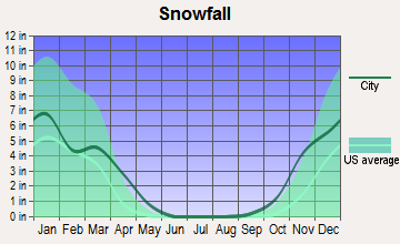
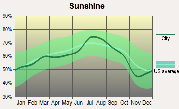
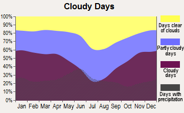
Average climate in Lambert, Montana
Based on data reported by over 4,000 weather stations
Earthquake activity:
Lambert-area historical earthquake activity is significantly above Montana state average. It is 195% greater than the overall U.S. average.On 8/18/1959 at 06:37:13, a magnitude 7.7 (7.7 UK, Class: Major, Intensity: VIII - XII) earthquake occurred 359.9 miles away from Lambert center, causing $26,000,000 total damage
On 10/28/1983 at 14:06:06, a magnitude 7.3 (6.2 MB, 7.3 MS, 7.0 MW) earthquake occurred 505.5 miles away from Lambert center, causing 2 deaths (2 shaking deaths) and 3 injuries, causing $15,000,000 total damage
On 6/30/1975 at 18:54:13, a magnitude 6.1 (5.6 MB, 5.9 MS, 6.1 UK, 6.1 ML, Class: Strong, Intensity: VII - IX) earthquake occurred 358.4 miles away from the city center
On 7/6/2017 at 06:30:17, a magnitude 5.8 (5.8 MW, Depth: 7.6 mi, Class: Moderate, Intensity: VI - VII) earthquake occurred 373.5 miles away from the city center
On 9/8/1984 at 00:59:31, a magnitude 5.1 (5.1 MB) earthquake occurred 250.6 miles away from the city center
On 5/29/1984 at 20:18:32, a magnitude 5.0 (5.0 MB) earthquake occurred 250.9 miles away from Lambert center
Magnitude types: body-wave magnitude (MB), local magnitude (ML), surface-wave magnitude (MS), moment magnitude (MW)
Natural disasters:
The number of natural disasters in Richland County (6) is a lot smaller than the US average (15).Major Disasters (Presidential) Declared: 4
Emergencies Declared: 1
Causes of natural disasters: Floods: 3, Storms: 2, Hurricane: 1, Snow: 1, Winter Storm: 1, Other: 1 (Note: some incidents may be assigned to more than one category).
Airports located in Lambert:
- Prevost Airport (20MT) (Runways: 1)
Colleges/universities with over 2000 students nearest to Lambert:
- Minot State University (about 162 miles; Minot, ND; Full-time enrollment: 2,887)
- Bismarck State College (about 194 miles; Bismarck, ND; FT enrollment: 3,015)
- University of Mary (about 200 miles; Bismarck, ND; FT enrollment: 2,854)
- Montana State University-Billings (about 226 miles; Billings, MT; FT enrollment: 4,319)
- Black Hills State University (about 229 miles; Spearfish, SD; FT enrollment: 3,166)
- Sheridan College (about 233 miles; Sheridan, WY; FT enrollment: 2,070)
- South Dakota School of Mines and Technology (about 265 miles; Rapid City, SD; FT enrollment: 2,102)
Public high school in Lambert:
- LAMBERT HIGH SCHOOL (Students: 37, Location: 121 3RD AVE NW, Grades: 9-12)
Public elementary/middle schools in Lambert:
- LAMBERT SCHOOL (Students: 37, Location: 121 3RD AVE NW, Grades: PK-6)
- LAMBERT 7-8 (Students: 11, Location: 121 3RD AVE NW, Grades: 7-8)
Points of interest:
Notable locations in Lambert: Midway Community Center (A), Nortana Grain Company Elevator (B), Kuester Reservoir Fishing Access Site (C), Historical Society Museum (D), Lambert Rural Fire District (E), Richland County Ambulance Lambert (F). Display/hide their locations on the map
Churches in Lambert include: First Lutheran Church (A), Saint Theresas Catholic Church (B), Christian and Missionary Alliance Church (C). Display/hide their locations on the map
Cemeteries: Lambert Cemetery (1), Lambert Catholic Cemetery (2). Display/hide their locations on the map
Lakes and reservoirs: Fox Lake (A), Latka Reservoir (B), Prevost Reservoir Number 2 (C), Erickson Reservoir (D), Kuester Lake (E). Display/hide their locations on the map
Creeks: East Fork Fox Creek (A), Spring Creek (B), Duplisse Creek (C), West Fork Fox Creek (D), Middle Fork Fox Creek (E), Long Grass Creek (F), Main Hay Creek (G), Muskrat Creek (H), North Fork East Redwater Creek (I). Display/hide their locations on the map
Parks in Lambert include: Fox Lake Wildlife Management Area (1), Lambert Park (2). Display/hide their locations on the map
Birthplace of: Donald Grant Nutter - 15th Governor of Montana..
Drinking water stations with addresses in Lambert and their reported violations in the past:
LAMBERT SEWER AND WATER ASSN (Population served: 150, Groundwater):Past health violations:Past monitoring violations:
- MCL, Average - Between JUL-2014 and SEP-2014, Contaminant: Fluoride. Follow-up actions: St No addtl Formal Action needed (JUL-31-2014), St Public Notif requested (SEP-23-2014), St Violation/Reminder Notice (SEP-23-2014)
- MCL, Average - Between APR-2014 and JUN-2014, Contaminant: Fluoride. Follow-up actions: St Public Notif requested (JUL-17-2014), St Violation/Reminder Notice (JUL-17-2014), St No addtl Formal Action needed (JUL-31-2014)
- Lead Consumer Notice - In JAN-01-2012, Contaminant: Lead and Copper Rule. Follow-up actions: St Violation/Reminder Notice (FEB-15-2012), St Compliance achieved (MAR-07-2012)
- Monitoring and Reporting (DBP) - Between OCT-2009 and DEC-2009, Contaminant: Chlorine. Follow-up actions: St Public Notif requested (JAN-24-2010), St Violation/Reminder Notice (JAN-24-2010), St No addtl Formal Action needed (APR-20-2010), Fed FAO issued (JUN-28-2010), St Public Notif received (JUL-27-2010), St Compliance achieved (OCT-15-2010), St Public Notif received (DEC-23-2010)
- Monitoring, Repeat Major (TCR) - In SEP-2009, Contaminant: Coliform (TCR). Follow-up actions: St Public Notif requested (OCT-16-2009), St Violation/Reminder Notice (OCT-16-2009), St Compliance achieved (APR-12-2010), St No addtl Formal Action needed (APR-20-2010), Fed FAO issued (JUN-28-2010), St Public Notif received (JUL-27-2010), St No addtl Formal Action needed (DEC-15-2010), St Public Notif received (DEC-23-2010)
- Monitoring and Reporting (DBP) - Between JUL-2009 and SEP-2009, Contaminant: Chlorine. Follow-up actions: St Public Notif requested (NOV-14-2009), St Violation/Reminder Notice (NOV-14-2009), St Public Notif requested (MAR-15-2010), St Violation/Reminder Notice (MAR-15-2010), St No addtl Formal Action needed (APR-20-2010), Fed FAO issued (JUN-28-2010), St Public Notif received (JUL-27-2010), St Compliance achieved (OCT-15-2010), St Public Notif received (DEC-23-2010), St Compliance achieved (FEB-09-2011)
- Follow-up Or Routine LCR Tap M/R - In OCT-01-2007, Contaminant: Lead and Copper Rule. Follow-up actions: St Public Notif requested (JAN-19-2008), St Violation/Reminder Notice (JAN-19-2008), St Other (JUL-31-2008), St Civil Case under development (SEP-11-2008), St Compliance achieved (SEP-30-2008), St AO (w/penalty) issued (MAR-05-2009), Fed FAO issued (JUN-28-2010), St Public Notif received (JUL-27-2010)
- 5 routine major monitoring violations
- 43 regular monitoring violations
| This place: | 2.4 people |
| Montana: | 2.4 people |
| This place: | 65.3% |
| Whole state: | 62.8% |
| This place: | 6.3% |
| Whole state: | 6.7% |
Likely homosexual households (counted as self-reported same-sex unmarried-partner households)
- Lesbian couples: 0.0% of all households
- Gay men: 0.9% of all households
| This place: | 22.5% |
| Whole state: | 14.6% |
| This place: | 7.9% |
| Whole state: | 5.8% |
For population 15 years and over in Lambert:

- Never married: 23.2%
- Now married: 67.7%
- Separated: 0.0%
- Widowed: 5.8%
- Divorced: 3.3%
For population 25 years and over in Lambert:
- High school or higher: 85.6%
- Bachelor's degree or higher: 21.6%
- Graduate or professional degree: 5.3%
- Unemployed: 2.0%
- Mean travel time to work (commute): 11.8 minutes


| Here: | 10.6 |
| Montana average: | 10.4 |
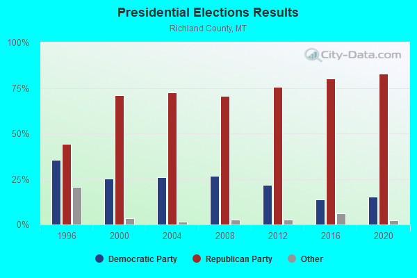
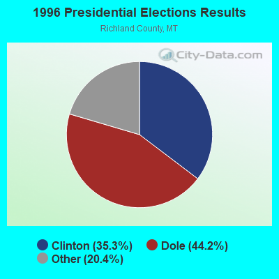

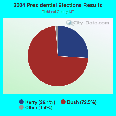
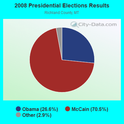
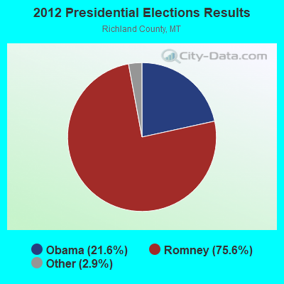
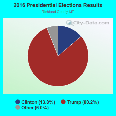
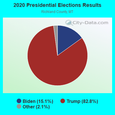
Graphs represent county-level data. Detailed 2008 Election Results
Religion statistics for Lambert, MT (based on Richland County data)
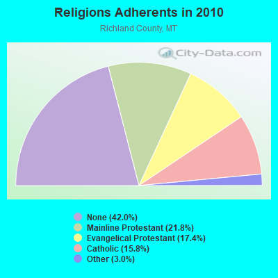
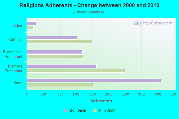
| Religion | Adherents | Congregations |
|---|---|---|
| Mainline Protestant | 2,125 | 10 |
| Evangelical Protestant | 1,699 | 15 |
| Catholic | 1,539 | 5 |
| Other | 289 | 1 |
| None | 4,094 | - |
Food Environment Statistics:
| This county: | 4.36 / 10,000 pop. |
| Montana: | 2.55 / 10,000 pop. |
| This county: | 1.09 / 10,000 pop. |
| Montana: | 0.48 / 10,000 pop. |
| Richland County: | 5.45 / 10,000 pop. |
| Montana: | 4.69 / 10,000 pop. |
| Here: | 11.99 / 10,000 pop. |
| State: | 10.38 / 10,000 pop. |
| This county: | 9.0% |
| Montana: | 7.2% |
| This county: | 28.3% |
| State: | 23.1% |
| Here: | 11.0% |
| Montana: | 10.7% |
Strongest AM radio stations in Lambert:
- KEYZ (660 AM; 5 kW; WILLISTON, ND; Owner: COMMONWEALTH LICENSE SUBSIDIARY, LLC)
- KXMR (710 AM; 50 kW; BISMARCK, ND; Owner: RADIO BISMARCK MANDAN, LLC)
- KATL (770 AM; 10 kW; MILES CITY, MT; Owner: STAR PRINTING COMPANY)
- KATQ (1070 AM; daytime; 5 kW; PLENTYWOOD, MT; Owner: RADIO INTERNAT'L-KATQ B/CAST ASSOC.)
- KMTA (1050 AM; 10 kW; MILES CITY, MT; Owner: SENGER BROADCASTING CORPORATION)
- KGLE (590 AM; 1 kW; GLENDIVE, MT; Owner: FRIENDS OF CHRISTIAN RADIO, INC.)
- KFLN (960 AM; 5 kW; BAKER, MT; Owner: NEWELL BROADCASTING INC.)
- KBHB (810 AM; 25 kW; STURGIS, SD; Owner: MONTEREY LICENSES, LLC)
- KTWO (1030 AM; 50 kW; CASPER, WY; Owner: CITICASTERS LICENSES, L.P.)
- WWNL (1080 AM; 50 kW; PITTSBURGH, PA; Owner: STEEL CITY RADIO, INC.)
- KXGN (1400 AM; 1 kW; GLENDIVE, MT; Owner: GLENDIVE BROADCASTING CORP.)
- KERR (750 AM; 50 kW; POLSON, MT; Owner: ANDERSON RADIO BROADCASTING, INC.)
- KLTC (1460 AM; 5 kW; DICKINSON, ND; Owner: CLEAR CHANNEL BROADCASTING LICENSES, INC.)
Strongest FM radio stations in Lambert:
- K201FG (88.1 FM; CULBERTSON, MT; Owner: CALVARY CHAPEL OF TWIN FALLS, INC.)
- KTHC (95.1 FM; SIDNEY, MT; Owner: COMMONWEALTH LICENSE SUBSIDIARY, LLC)
- KYYZ (96.1 FM; WILLISTON, ND; Owner: COMMONWEALTH LICENSE SUBSIDIARY, LLC)
- KDSR (101.1 FM; WILLISTON, ND; Owner: WILLISTON COMMUNITY BROADCASTING CORP. D/B/A KDSR(FM))
Lambert fatal accident list:
FCC Registered Cell Phone Towers:
2- 13055 County Rd. 328 (Lat: 47.797972 Lon: -104.636833), Type: Ltower, Structure height: 54.9 m, Overall height: 60.7 m, Call Sign: KNKR290
Assigned Frequencies: 880.020 MHz, 835.020 MHz, 891.510 MHz, 846.510 MHz, 880.020 MHz, 880.020 MHz, 835.020 MHz, 835.020 MHz, 891.510 MHz, 891.510 MHz, 846.510 MHz, 846.510 MHzGrant Date: 11/22/2016, Expiration Date: 12/16/2026, Certifier: Gregory M RomanoRegistrant: Verizon, 1300 I Street, Nw - 500 East, Washington, DC 20005, Phone: (202) 515-2453, Email:
- 13770 County Road #317 (Lat: 47.891667 Lon: -104.891139), Type: Gtower, Structure height: 54.9 m, Overall height: 60.6 m, Call Sign: KNKR290
Assigned Frequencies: 880.020 MHz, 880.020 MHz, 880.020 MHz, 835.020 MHz, 835.020 MHz, 835.020 MHz, 891.510 MHz, 891.510 MHz, 891.510 MHz, 846.510 MHz, 846.510 MHz, 846.510 MHzGrant Date: 11/22/2016, Expiration Date: 12/16/2026, Certifier: Gregory M RomanoRegistrant: Verizon, 1300 I Street, Nw - 500 East, Washington, DC 20005, Phone: (202) 515-2453, Email:
FCC Registered Broadcast Land Mobile Towers:
2- 8 Mi Ne (Lat: 47.794472 Lon: -104.571889), Type: Pole, Structure height: 12.6 m, Overall height: 15 m, Call Sign: KNET769,
Assigned Frequencies: 151.535 MHz, Grant Date: 07/31/2013, Expiration Date: 04/05/2023, Cancellation Date: 06/10/2023, Registrant: Advanced Communications, 1540 South Central, Sidney, MT 59270, Phone: (406) 433-1659, Fax: (406) 433-1662, Email:
- 6.1 Mi Sse On Cr (Lat: 47.600583 Lon: -104.583833), Call Sign: KNBH721,
Assigned Frequencies: 451.450 MHz, Grant Date: 01/02/2015, Expiration Date: 01/29/2025, Registrant: Communications Advisory Counsel, 5151 Wisconsin Avenue N.W. Suite 311, Washington, DC 20016, Phone: (202) 333-5273, Fax: (202) 333-5274, Email:
FCC Registered Microwave Towers:
4- MRAR, 8.0 Mi@355 Deg From Lambert Mt (Lat: 47.797694 Lon: -104.635528), Type: Tower, Structure height: 45.7 m, Overall height: 48.7 m, Call Sign: WQLW662,
Assigned Frequencies: 928.281 MHz, 952.281 MHz, Grant Date: 04/30/2020, Expiration Date: 05/12/2030, Certifier: David D Matamoros, Registrant: White Rock Oil & Gas, LLC, 5810 Tennyson Parkway Suite 500, Plano, TX 75024, Phone: (214) 981-1400, Email:
- BR 41-35h 52, 20.7 Mi @ 310 Deg From (Lat: 47.881028 Lon: -104.957444), Type: Ltower, Structure height: 54.8 m, Overall height: 58.5 m, Call Sign: WQLX946,
Assigned Frequencies: 928.756 MHz, 952.756 MHz, Grant Date: 04/30/2020, Expiration Date: 05/24/2030, Certifier: David D Matamoros, Registrant: White Rock Oil & Gas, LLC, 5810 Tennyson Parkway Suite 500, Plano, TX 75024, Phone: (214) 981-1400, Email:
- Power Line, 17.2 Mi @ 343.4 Deg From Lambert Mt (Lat: 47.925556 Lon: -104.725694), Type: Tower, Structure height: 13.7 m, Overall height: 15.2 m, Call Sign: WQLY332,
Assigned Frequencies: 928.456 MHz, 952.456 MHz, Grant Date: 04/30/2020, Expiration Date: 05/25/2030, Certifier: David D Matamoros, Registrant: White Rock Oil & Gas, LLC, 5810 Tennyson Parkway Suite 500, Plano, TX 75024, Phone: (214) 981-1400, Email:
- LAMBERT, Nw 1/4 Sec7-Twp 21n-R56e (Lat: 47.600556 Lon: -104.583833), Overall height: 45.7 m, Call Sign: WHT240,
Assigned Frequencies: 2168.40 MHz, 2178.00 MHz, Expiration Date: 02/01/2001, Cancellation Date: 10/02/1996, Registrant: Mid Rivers Telephone Cooperative Inc, 106 Second Ave South, Circle, MT 59215
FAA Registered Aircraft:
10 (See the full list of FAA Registered Aircraft in Lambert)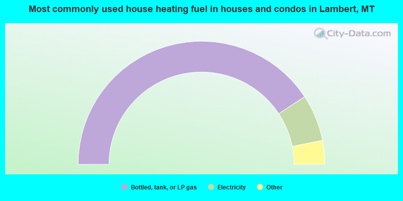
- 81.5%Bottled, tank, or LP gas
- 12.3%Electricity
- 3.1%Coal or coke
- 2.1%Fuel oil, kerosene, etc.
- 1.0%Utility gas
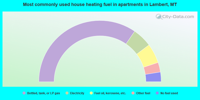
- 69.2%Bottled, tank, or LP gas
- 10.3%Electricity
- 10.3%Fuel oil, kerosene, etc.
- 5.1%Other fuel
- 5.1%No fuel used
Lambert compared to Montana state average:
- Unemployed percentage significantly below state average.
- Black race population percentage significantly below state average.
- Hispanic race population percentage significantly below state average.
- Foreign-born population percentage significantly below state average.
- Length of stay since moving in significantly above state average.
- Number of rooms per house significantly below state average.
- House age significantly below state average.
- Number of college students below state average.
Lambert on our top lists:
- #9 on the list of "Top 101 cities with the most cars per house, population 500+"