Lanai, Hawaii

Submit your own pictures of this place and show them to the world
- OSM Map
- General Map
- Google Map
- MSN Map
| Males: 1,773 | |
| Females: 1,746 |
| Median resident age: | 35.6 years |
| Hawaii median age: | 36.2 years |
Zip code: 96763
| Lanai: | $82,854 |
| HI: | $92,458 |
Estimated per capita income in 2022: $37,471 (it was $18,668 in 2000)
Lanai CCD income, earnings, and wages data
Estimated median house or condo value in 2022: $545,457 (it was $143,000 in 2000)
| Lanai: | $545,457 |
| HI: | $820,100 |
Mean prices in 2022: all housing units: over $1,000,000; detached houses: over $1,000,000; townhouses or other attached units: over $1,000,000; in 2-unit structures: over $1,000,000; in 3-to-4-unit structures: over $1,000,000; in 5-or-more-unit structures: $647,128; mobile homes: $419,123; occupied boats, rvs, vans, etc.: $440,344
Detailed information about poverty and poor residents in Lanai, HI


- 1,77555.6%Asian alone
- 52716.5%Two or more races
- 41112.9%White alone
- 2457.7%Hispanic
- 2196.9%Native Hawaiian and Other
Pacific Islander alone - 110.3%American Indian alone
- 40.1%Black alone
- 10.03%Other race alone

Races in Lanai detailed stats: ancestries, foreign born residents, place of birth
 Recent articles from our blog. Our writers, many of them Ph.D. graduates or candidates, create easy-to-read articles on a wide variety of topics.

Current Local Time: HST (no DST) time zone
Elevation: 1624 feet
Land area: 140.5 square miles.
Population density: 25 people per square mile (very low).

| Lanai CCD: | 0.2% ($275) |
| Hawaii: | 0.3% ($765) |
Nearest city with pop. 50,000+: Honolulu, HI  (67.6 miles , pop. 371,657).
Nearest city with pop. 1,000,000+: Los Angeles, CA (2518.8 miles , pop. 3,694,820).
Nearest cities:
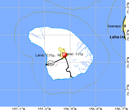
), ), ), Latitude: 20.83 N, Longitude: 156.92 W
Area code: 808


| Here: | 5.3% |
| Hawaii: | 2.9% |

- Accommodation & food services (42.8%)
- Educational services (9.2%)
- Administrative & support & waste management services (6.8%)
- Construction (6.1%)
- Arts, entertainment, recreation (5.9%)
- Health care (3.3%)
- Real estate & rental & leasing (2.4%)

- Accommodation & food services (39.1%)
- Arts, entertainment, recreation (10.6%)
- Construction (9.5%)
- Administrative & support & waste management services (8.2%)
- Educational services (5.9%)
- Air transportation (3.4%)
- Agriculture, forestry, fishing & hunting (3.3%)

- Accommodation & food services (46.2%)
- Educational services (12.4%)
- Administrative & support & waste management services (5.4%)
- Health care (4.6%)
- Construction (3.0%)
- Public administration (3.0%)
- Finance & insurance (3.0%)

- Building and grounds cleaning and maintenance occupations (15.0%)
- Cooks and food preparation workers (6.4%)
- Other management occupations, except farmers and farm managers (6.2%)
- Waiters and waitresses (5.7%)
- Other food preparation and serving workers, including supervisors (4.7%)
- Information and record clerks, except customer service representatives (4.7%)
- Other office and administrative support workers, including supervisors (3.5%)

- Building and grounds cleaning and maintenance occupations (12.8%)
- Other management occupations, except farmers and farm managers (8.7%)
- Other food preparation and serving workers, including supervisors (7.3%)
- Information and record clerks, except customer service representatives (5.5%)
- Waiters and waitresses (5.2%)
- Cooks and food preparation workers (5.1%)
- Supervisors and other personal care and service workers, except child care workers (4.4%)

- Building and grounds cleaning and maintenance occupations (17.1%)
- Cooks and food preparation workers (7.6%)
- Waiters and waitresses (6.2%)
- Other office and administrative support workers, including supervisors (5.5%)
- Other management occupations, except farmers and farm managers (4.0%)
- Information and record clerks, except customer service representatives (3.9%)
- Preschool, kindergarten, elementary, and middle school teachers (3.7%)
Average climate in Lanai, Hawaii
Based on data reported by over 4,000 weather stations


|
|

Earthquake activity:
Lanai-area historical earthquake activity is significantly above Hawaii state average. It is 1611% greater than the overall U.S. average.On 11/29/1975 at 14:47:40, a magnitude 7.2 (6.0 MB, 7.1 MS, 7.2 UK, 7.2 MS, Class: Major, Intensity: VIII - XII) earthquake occurred 154.8 miles away from the city center, causing 2 deaths (2 shaking deaths)
On 8/21/1951 at 10:57:00, a magnitude 6.9 (6.9 UK, Class: Strong, Intensity: VII - IX) earthquake occurred 95.3 miles away from the city center
On 10/15/2006 at 17:07:49, a magnitude 6.7 (6.2 MB, 6.6 MS, 6.7 MW) earthquake occurred 89.9 miles away from the city center
On 10/15/2006 at 17:07:49, a magnitude 6.7 (6.7 MD, Depth: 23.7 mi) earthquake occurred 91.5 miles away from Lanai center
On 5/4/2018 at 22:32:54, a magnitude 6.9 (6.9 MW, Depth: 3.6 mi) earthquake occurred 162.4 miles away from Lanai center
On 11/16/1983 at 16:13:00, a magnitude 6.7 (6.4 MB, 6.7 MS, 6.7 MW) earthquake occurred 138.7 miles away from Lanai center, causing $6,000,000 total damage
Magnitude types: body-wave magnitude (MB), duration magnitude (MD), surface-wave magnitude (MS), moment magnitude (MW)
Natural disasters:
The number of natural disasters in Maui County (16) is near the US average (15).Major Disasters (Presidential) Declared: 10
Causes of natural disasters: Floods: 6, Fires: 4, Storms: 4, Heavy Rains: 2, High Surfs: 2, Hurricanes: 2, Landslides: 2, Mudslides: 2, Earthquake: 1, Tropical Storm: 1, Tsunami Wave: 1, Other: 1 (Note: some incidents may be assigned to more than one category).

Hospitals and medical centers in Lanai:
Colleges/universities with over 2000 students nearest to Lanai:
- University of Hawaii Maui College (about 29 miles; Kahului, HI; Full-time enrollment: 2,492)
- Kapiolani Community College (about 65 miles; Honolulu, HI; FT enrollment: 5,069)
- Chaminade University of Honolulu (about 66 miles; Honolulu, HI; FT enrollment: 2,610)
- University of Hawaii at Manoa (about 67 miles; Honolulu, HI; FT enrollment: 16,461)
- Hawaii Pacific University (about 70 miles; Honolulu, HI; FT enrollment: 5,506)
- Honolulu Community College (about 71 miles; Honolulu, HI; FT enrollment: 2,538)
- Leeward Community College (about 80 miles; Pearl City, HI; FT enrollment: 4,589)
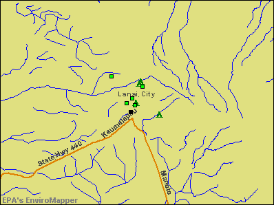
Points of interest:
Notable locations in Lanai: Cavendish Golf Course (A), Federation Camp (B), Garden of the Gods (C), Luahiwa (D), Palaoa Point Light (E), American Medical Response Station Medic 13 Lanai (F), Lāna‘i Public and School Library (G), Lanai Fire Station (H). Display/hide their locations on the map
Churches in Lanai include: Lokahi O Ka Malamalama Church (A), Lāna‘i Union Church (B), Lāna‘i Seventh Day Adventist Church (C), Lāna‘i Hongwanji Mission Home (D), Lāna‘i Baptist Church (E), Kingdom Hall of Jehovahs Witnesses (F), Ka Lanakila o Ka Malamalama Church (G), First Assembly of God Church (H). Display/hide their locations on the map
Reservoir: Kaa Fishpond (A). Display/hide its location on the map
Park in Lanai: Dole Park (1). Display/hide its location on the map
Beaches: Polihua Beach (A), Hulopoe Beach (B), Kalakala (C), Iamo (D), Waiopae (E), Kahea (F), Honowae (G), Keomuku (H), Kahokunui (I). Display/hide their locations on the map
Birthplace of: Danny Lockin - Actor.
| This place: | 2.7 people |
| Hawaii: | 2.9 people |
| This place: | 68.0% |
| Whole state: | 68.9% |
| This place: | 7.8% |
| Whole state: | 7.3% |
Likely homosexual households (counted as self-reported same-sex unmarried-partner households)
- Lesbian couples: 0.2% of all households
- Gay men: 0.1% of all households
| This place: | 9.5% |
| Whole state: | 10.7% |
| This place: | 5.7% |
| Whole state: | 5.0% |
For population 15 years and over in Lanai:

- Never married: 27.8%
- Now married: 57.9%
- Separated: 1.4%
- Widowed: 6.6%
- Divorced: 7.7%
For population 25 years and over in Lanai:
- High school or higher: 69.4%
- Bachelor's degree or higher: 16.5%
- Graduate or professional degree: 3.5%
- Unemployed: 5.0%
- Mean travel time to work (commute): 13.3 minutes


| Here: | 18.0 |
| Hawaii average: | 12.8 |
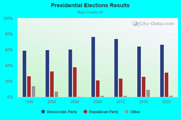
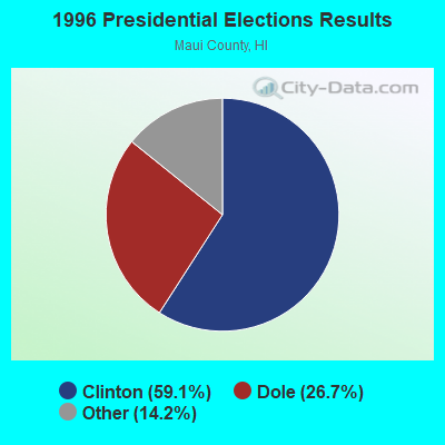
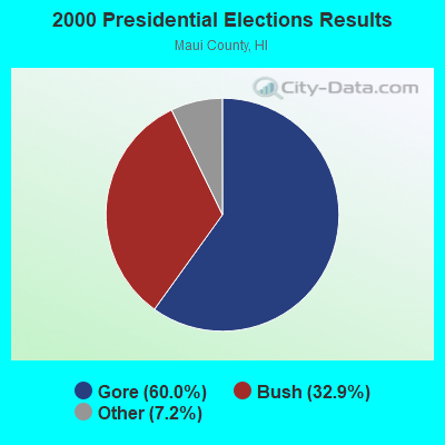
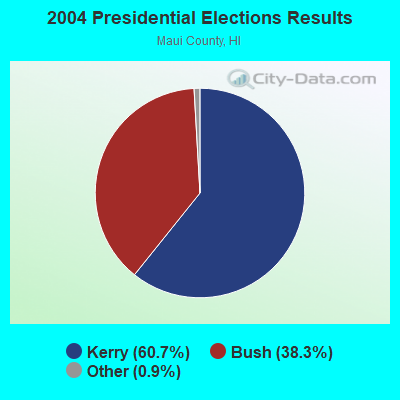
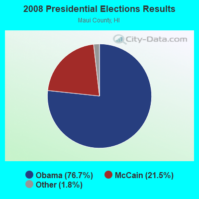
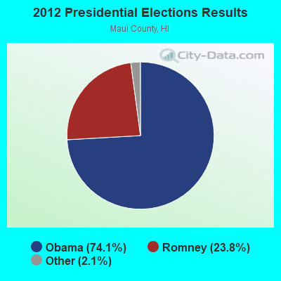
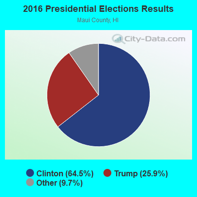
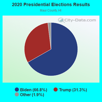
Graphs represent county-level data. Detailed 2008 Election Results
Religion statistics for Lanai, HI (based on Maui County data)
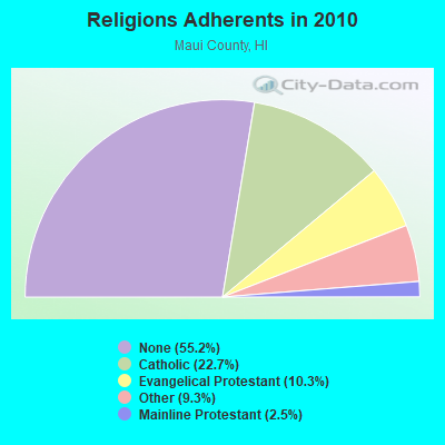
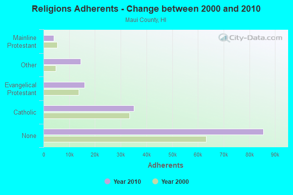
| Religion | Adherents | Congregations |
|---|---|---|
| Catholic | 35,179 | 22 |
| Evangelical Protestant | 15,928 | 76 |
| Other | 14,353 | 53 |
| Mainline Protestant | 3,902 | 37 |
| Orthodox | 15 | 1 |
| None | 85,457 | - |
Food Environment Statistics:
| Maui County: | 2.90 / 10,000 pop. |
| Hawaii: | 2.30 / 10,000 pop. |
| Maui County: | 0.07 / 10,000 pop. |
| Hawaii: | 0.09 / 10,000 pop. |
| This county: | 1.84 / 10,000 pop. |
| Hawaii: | 1.57 / 10,000 pop. |
| This county: | 2.12 / 10,000 pop. |
| Hawaii: | 1.72 / 10,000 pop. |
| This county: | 13.44 / 10,000 pop. |
| State: | 9.00 / 10,000 pop. |
| Maui County: | 7.4% |
| State: | 8.1% |
| Maui County: | 22.6% |
| Hawaii: | 20.8% |
| Maui County: | 10.6% |
| State: | 9.2% |
Strongest AM radio stations in Lanai:
- KAIM (870 AM; 50 kW; HONOLULU, HI; Owner: SALEM MEDIA OF HAWAII, INC.)
- KUAU (1570 AM; 50 kW; HAIKU, HI; Owner: FIRST ASSEMBLY OF GOD-KAHULUI, MAUI)
- KMVI (550 AM; 5 kW; WAILUKU, HI; Owner: PACIFIC RADIO GROUP,INC.)
- KNUI (900 AM; 5 kW; KAHULUI, HI; Owner: PACIFIC RADIO GROUP, INC.)
- KAOI (1110 AM; 5 kW; KIHEI, HI; Owner: VISIONARY RELATED ENTERTAINMENT, INC)
- KORL (690 AM; 10 kW; HONOLULU, HI; Owner: NEW WAVE BROADCASTING, L.P.)
- KGU (760 AM; 10 kW; HONOLULU, HI; Owner: SALEM MEDIA OF HAWAII, INC.)
- KSSK (590 AM; 8 kW; HONOLULU, HI; Owner: CAPSTAR TX LIMITED PARTNERSHIP)
- KHVH (830 AM; 10 kW; HONOLULU, HI; Owner: CAPSTAR TX LIMITED PARTNERSHIP)
- KHNR (650 AM; 10 kW; HONOLULU, HI; Owner: SALEM MEDIA OF HAWAII, INC.)
- KLHT (1040 AM; 10 kW; HONOLULU, HI; Owner: CALVARY CHAPEL OF HONOLULU, INC.)
- KHCM (940 AM; 10 kW; WAIPAHU, HI; Owner: SALEM MEDIA OF HAWAII, INC.)
- KUMU (1500 AM; 10 kW; HONOLULU, HI; Owner: MAVERICK MEDIA OF OAHU LICENSE LLC)
Strongest FM radio stations in Lanai:
- KPOA (93.5 FM; LAHAINA, HI; Owner: PACIFIC RADIO GROUP, INC.)
- KKUA (90.7 FM; WAILUKU, HI; Owner: HAWAII PUBLIC RADIO, INC.)
- K220HA (91.9 FM; KIHEI, HI; Owner: CALVARY CHAPEL OF TWIN FALLS, INC.)
- K210CM (89.9 FM; KIHEI, HI; Owner: CALVARY CHAPEL OF TWIN FALLS, INC.)
- KONI (104.7 FM; LANAI CITY, HI; Owner: HOCHMAN HAWAII PUBLISHING, INC.)
- KLHI-FM (101.1 FM; LAHAINA, HI; Owner: PACIFIC RADIO GROUP, INC.)
- KNUI-FM (99.9 FM; KAHULUI, HI; Owner: PACIFIC RADIO GROUP, INC.)
- K244DN (96.7 FM; HONOKOWA, ETC., HI; Owner: VISIONARY RELATED ENTERTAINMENT, INC)
- KJMD (98.3 FM; PUKALANI, HI; Owner: PACIFIC RADIO GROUP,INC.)
- KAOI-FM (95.1 FM; WAILUKU, HI; Owner: VISIONARY RELATED ENTERTAINMENT INC)
- K272CT (102.3 FM; KAHULUI, HI; Owner: PACIFIC RADIO GROUP, INC.)
- KXME (104.3 FM; KANEOHE, HI; Owner: CXR HOLDINGS, INC.)
- KRTR-FM (96.3 FM; KAILUA, HI; Owner: CXR HOLDINGS, INC.)
- K205EB (88.9 FM; LANAI, HI; Owner: CALVARY CHAPEL OF TWIN FALLS, INC.)
FCC Registered Cell Phone Towers:
4 (See the full list of FCC Registered Cell Phone Towers in Lanai)FCC Registered Antenna Towers:
39 (See the full list of FCC Registered Antenna Towers)FCC Registered Commercial Land Mobile Towers:
1 (See the full list of FCC Registered Commercial Land Mobile Towers in Lanai, HI)FCC Registered Private Land Mobile Towers:
2 (See the full list of FCC Registered Private Land Mobile Towers)FCC Registered Broadcast Land Mobile Towers:
15 (See the full list of FCC Registered Broadcast Land Mobile Towers)FCC Registered Microwave Towers:
26 (See the full list of FCC Registered Microwave Towers in this town)FCC Registered Maritime Coast & Aviation Ground Towers:
7 (See the full list of FCC Registered Maritime Coast & Aviation Ground Towers)FCC Registered Amateur Radio Licenses:
1- Call Sign: WH6DNE, Licensee ID: L01581626, Grant Date: 01/28/2021, Expiration Date: 07/08/2030, Certifier: Kendra N Medeiros, Registrant: Kendra N Medeiros, Lanai, HI 96763
FAA Registered Aircraft:
3- Aircraft: CESSNA 177A (Category: Land, Seats: 4, Weight: Up to 12,499 Pounds, Speed: 108 mph), Engine: LYCOMING O&VO-360 SER (180 HP) (Reciprocating)
N-Number: 30446, N30446, N-30446, Serial Number: 17701260, Year manufactured: 1968, Airworthiness Date: 09/05/1980, Certificate Issue Date: 11/17/2015
Registrant (Individual): Terry J Gumz, Po Box 630401, Lanai City, HI 96763 - Aircraft: CESSNA 172M (Category: Land, Seats: 4, Weight: Up to 12,499 Pounds, Speed: 108 mph), Engine: LYCOMING 0-320 SERIES (180 HP) (4 Cycle)
N-Number: 73028, N73028, N-73028, Serial Number: 17267241, Year manufactured: 1976, Airworthiness Date: 05/25/1976, Certificate Issue Date: 12/10/2013
Registrant (Individual): Craig H Halley, Po Box 631550, Lanai City, HI 96763 - Aircraft: BEECH D-50 (Category: Land, Engines: 2, Seats: 6, Weight: Up to 12,499 Pounds, Speed: 167 mph), Engine: LYCOMING GO-480 SERIES (295 HP) (Reciprocating)
N-Number: 4342D, N4342D, N-4342D, Serial Number: DH-95, Year manufactured: 1956, Airworthiness Date: 07/12/1956, Certificate Issue Date: 02/14/2000
Registrant (Co-Owned): Javin K Whittinghill, 354 Lanai Ave, Lanai, HI 96763, Other Owners: Bonnie Graham
Deregistered: Cancel Date: 01/19/2018

- 56.5%Electricity
- 39.4%No fuel used
- 1.7%Bottled, tank, or LP gas
- 1.6%Solar energy
- 0.7%Utility gas

- 49.7%No fuel used
- 36.1%Electricity
- 11.9%Bottled, tank, or LP gas
- 2.4%Utility gas
Lanai compared to Hawaii state average:
- Median house value below state average.
- Unemployed percentage below state average.
- Black race population percentage significantly below state average.
- Foreign-born population percentage significantly below state average.
- Length of stay since moving in significantly above state average.
- Number of rooms per house significantly below state average.
- House age significantly below state average.
- Number of college students below state average.
- Percentage of population with a bachelor's degree or higher below state average.
Lanai on our top lists:
- #19 on the list of "Top 101 larger cities with the lowest real estate taxes percentage (population 50,000+)"
- #12 on the list of "Top 101 counties with the lowest average weight of females"
- #32 on the list of "Top 101 counties with the highest percentage of residents that exercised in the past month"
- #61 on the list of "Top 101 counties with highest percentage of residents voting for Obama (Democrat) in the 2012 Presidential Election"
- #74 on the list of "Top 101 counties with the lowest Particulate Matter (PM2.5) Annual air pollution readings in 2012 (µg/m3)"
- #74 on the list of "Top 101 counties with the highest ground withdrawal of fresh water for public supply (pop. 50,000+)"