Langdon, New Hampshire
Submit your own pictures of this town and show them to the world
- OSM Map
- General Map
- Google Map
- MSN Map

Population change since 2000: +17.4%
 |
| Males: 345 | |
| Females: 343 |
| Median resident age: | 45.5 years |
| New Hampshire median age: | 43.9 years |
Zip codes: 03602.
| Langdon: | $72,085 |
| NH: | $89,992 |
Estimated per capita income in 2022: $46,014 (it was $24,572 in 2000)
Langdon town income, earnings, and wages data
Estimated median house or condo value in 2022: $279,485 (it was $103,800 in 2000)
| Langdon: | $279,485 |
| NH: | $384,700 |
Mean prices in 2022: all housing units: $337,766; detached houses: $372,023; townhouses or other attached units: $454,943; in 2-unit structures: $245,522; in 3-to-4-unit structures: $240,260; in 5-or-more-unit structures: $222,243; mobile homes: $88,713
Detailed information about poverty and poor residents in Langdon, NH
Compare current foreclosures near Langdon, NH:
| Photo | Address | Area | Beds / Baths | Price | Details |
|---|---|---|---|---|---|

|
#1
W Terrace St
Claremont, NH 03743
|
988 sq. feet
|
1 baths 3 beds |
show details | |

|
#2
Elm St
Claremont, NH 03743
|
2,232 sq. feet
|
2 baths 4 beds |
show details | |

|
#3
S Koski Rd
Newport, NH 03773
|
1,596 sq. feet
|
2 baths 3 beds |
show details | |

|
#4
Laura Ln
Keene, NH 03431
|
912 sq. feet
|
1 baths 3 beds |
show details | |

|
#5
Pine Grove St
Claremont, NH 03743
|
2,304 sq. feet
|
1 baths 3 beds |
show details | |

|
#6
Acworth Rd
Charlestown, NH 03603
|
1,826 sq. feet
|
1 baths 3 beds |
show details | |

|
#7
Taylor Hill Rd
Charlestown, NH 03603
|
2,226 sq. feet
|
2 baths 4 beds |
show details | |

|
#8
Old Springfield Rd
Charlestown, NH 03603
|
1,848 sq. feet
|
1 baths 4 beds |
show details | |

|
#9
Morways Park
Charlestown, NH 03603
|
1,064 sq. feet
|
2 baths 2 beds |
show details | |

|
#10
Byrd Ave
Claremont, NH 03743
|
1,904 sq. feet
|
1 baths 3 beds |
show details |
| Photo | Address | Area | Beds / Baths | Price | Details |
|---|---|---|---|---|---|

|
#11
Dodge Pl
Claremont, NH 03743
|
1,650 sq. feet
|
2 baths 3 beds |
show details | |

|
#12
Elm St
Claremont, NH 03743
|
2,176 sq. feet
|
2 baths 5 beds |
show details | |

|
#13
Howard St # 2
Keene, NH 03431
|
- sq. feet
|
2 baths 3 beds |
show details | |

|
#14
Washington St
Keene, NH 03431
|
- sq. feet
|
1 baths 3 beds |
show details | |

|
#15
Washington St
Keene, NH 03431
|
- sq. feet
|
1 baths 3 beds |
show details | |

|
#16
Library Ave
Alstead, NH 03602
|
- sq. feet
|
- baths - beds |
show details | |

|
#17
Blood Rd
Newport, NH 03773
|
- sq. feet
|
- baths - beds |
show details | |

|
#18
Washington St
Keene, NH 03431
|
- sq. feet
|
- baths - beds |
show details | |

|
#19
Birch St
Keene, NH 03431
|
- sq. feet
|
- baths - beds |
show details | |

|
#20
Hubbard Rd
Sullivan, NH 03445
|
- sq. feet
|
- baths - beds |
show details |
| Photo | Address | Area | Beds / Baths | Price | Details |
|---|---|---|---|---|---|

|
#21
Court St Apt I
Keene, NH 03431
|
- sq. feet
|
- baths - beds |
show details | |

|
#22
River St
Alstead, NH 03602
|
- sq. feet
|
- baths - beds |
show details | |

|
#23
W Pleasant St
Claremont, NH 03743
|
- sq. feet
|
- baths - beds |
show details | |

|
#24
Roberts Rd
Springfield, VT 05156
|
- sq. feet
|
- baths - beds |
show details | |

|
#25
Dogwood Ln
Springfield, VT 05156
|
- sq. feet
|
- baths - beds |
show details | |

|
#26
Westview Ter
Springfield, VT 05156
|
- sq. feet
|
- baths - beds |
show details | |

|
#27
Gilsum Mine Rd
Alstead, NH 03602
|
- sq. feet
|
- baths - beds |
show details | |

|
#28
Edgebrook Park
Bellows Falls, VT 05101
|
- sq. feet
|
- baths - beds |
show details | |

|
#29
Spring St Apt 1
Keene, NH 03431
|
- sq. feet
|
- baths - beds |
show details | |

|
#30
Paine Rd
Westmoreland, NH 03467
|
- sq. feet
|
- baths - beds |
show details |
| Photo | Address | Area | Beds / Baths | Price | Details |
|---|---|---|---|---|---|

|
#31
Mcdonough Rd
Newport, NH 03773
|
- sq. feet
|
- baths - beds |
show details | |

|
#32
Taylor Dr
Springfield, VT 05156
|
- sq. feet
|
- baths - beds |
show details | |

|
#33
Upper Falls Rd
Perkinsville, VT 05151
|
- sq. feet
|
- baths - beds |
show details | |

|
#34
Murdough Hill Rd
Nelson, NH 03457
|
- sq. feet
|
- baths - beds |
show details | |

|
#35
Center St
North Walpole, NH 03609
|
- sq. feet
|
- baths - beds |
show details | |

|
Check over 1 million property listings on Foreclosure.com!
|
browse all offers | |||

- 67197.5%White alone
- 111.6%Hispanic
- 20.3%Asian alone
- 20.3%Two or more races
- 10.1%Black alone
- 10.1%American Indian alone
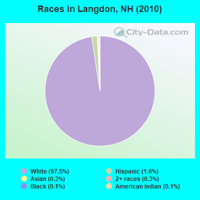
Races in Langdon detailed stats: ancestries, foreign born residents, place of birth
According to our research of New Hampshire and other state lists, there were 2 registered sex offenders living in Langdon, New Hampshire as of April 18, 2024.
The ratio of all residents to sex offenders in Langdon is 344 to 1.
Full-time law enforcement employees in 2004, including police officers: 1 (1 officers - 0 male; 1 female).
| Officers per 1,000 residents here: | 1.60 |
| New Hampshire average: | 2.03 |
 Recent articles from our blog. Our writers, many of them Ph.D. graduates or candidates, create easy-to-read articles on a wide variety of topics.


 | Acworth/Sullivan County (4 replies) |
| Langdon NH Covered Bridges (0 replies) |
| Wedding Venue Suggestions???? (40 replies) |
Latest news from Langdon, NH collected exclusively by city-data.com from local newspapers, TV, and radio stations
Ancestries: English (22.4%), Irish (13.8%), French (9.9%), French Canadian (9.0%), German (7.7%), Scottish (7.2%).
Current Local Time: EST time zone
Incorporated in 1787
Elevation: 674 feet
Land area: 16.3 square miles.
Population density: 42 people per square mile (very low).
20 residents are foreign born (2.7% Europe).
| This town: | 3.4% |
| New Hampshire: | 4.4% |
| Langdon town: | 2.0% ($2,122) |
| New Hampshire: | 2.3% ($2,946) |
Nearest city with pop. 50,000+: Manchester, NH  (48.7 miles , pop. 107,006).
Nearest city with pop. 200,000+: Boston, MA (88.0 miles , pop. 589,141).
Nearest city with pop. 1,000,000+: Bronx, NY (177.7 miles , pop. 1,332,650).
Nearest cities:
), ), ), ), ), Latitude: 43.17 N, Longitude: 72.38 W
Area code commonly used in this area: 603

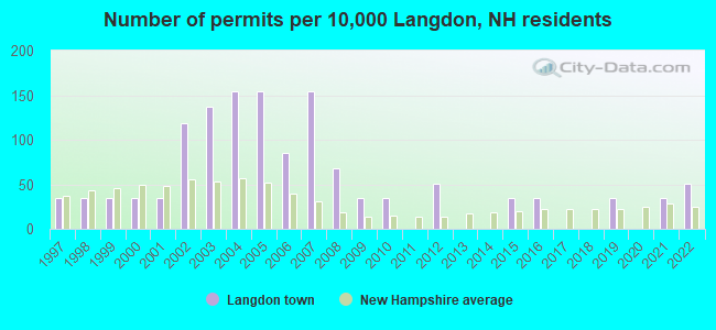
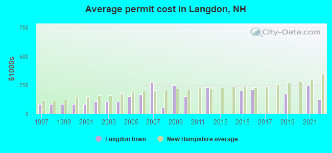
Single-family new house construction building permits:
- 2022: 3 buildings, average cost: $125,000
- 2021: 2 buildings, average cost: $250,000
- 2019: 2 buildings, average cost: $175,000
- 2016: 2 buildings, average cost: $212,500
- 2015: 2 buildings, average cost: $200,000
- 2012: 3 buildings, average cost: $233,300
- 2010: 2 buildings, average cost: $150,000
- 2009: 2 buildings, average cost: $250,000
- 2008: 4 buildings, average cost: $52,500
- 2007: 9 buildings, average cost: $275,000
- 2006: 5 buildings, average cost: $171,000
- 2005: 9 buildings, average cost: $150,200
- 2004: 9 buildings, average cost: $107,100
- 2003: 8 buildings, average cost: $107,100
- 2002: 7 buildings, average cost: $107,100
- 2001: 2 buildings, average cost: $85,000
- 2000: 2 buildings, average cost: $85,000
- 1999: 2 buildings, average cost: $85,000
- 1998: 2 buildings, average cost: $85,000
- 1997: 2 buildings, average cost: $85,000
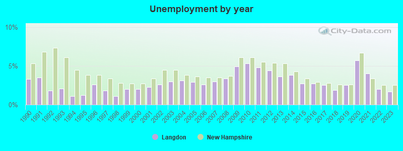
| Here: | 1.7% |
| New Hampshire: | 2.5% |
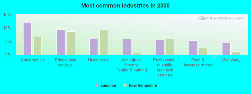
- Construction (12.1%)
- Educational services (9.4%)
- Health care (6.2%)
- Agriculture, forestry, fishing & hunting (5.9%)
- Professional, scientific, technical services (5.6%)
- Food & beverage stores (5.3%)
- Machinery (4.4%)
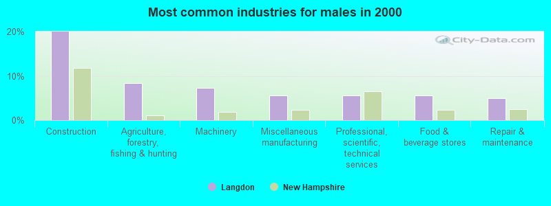
- Construction (20.0%)
- Agriculture, forestry, fishing & hunting (8.3%)
- Machinery (7.2%)
- Miscellaneous manufacturing (5.6%)
- Professional, scientific, technical services (5.6%)
- Food & beverage stores (5.6%)
- Repair & maintenance (5.0%)
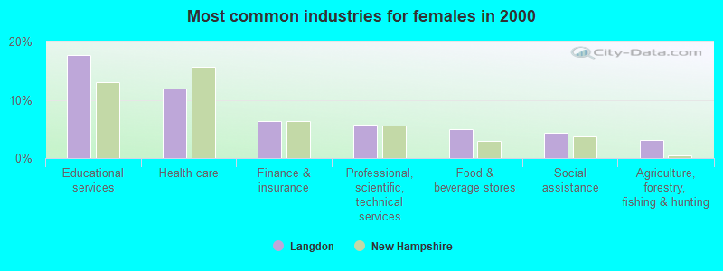
- Educational services (17.6%)
- Health care (11.9%)
- Finance & insurance (6.3%)
- Professional, scientific, technical services (5.7%)
- Food & beverage stores (5.0%)
- Social assistance (4.4%)
- Agriculture, forestry, fishing & hunting (3.1%)
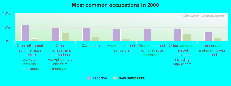
- Other office and administrative support workers, including supervisors (5.9%)
- Other management occupations, except farmers and farm managers (4.7%)
- Carpenters (4.7%)
- Assemblers and fabricators (4.4%)
- Secretaries and administrative assistants (4.4%)
- Other sales and related occupations, including supervisors (4.4%)
- Laborers and material movers, hand (3.2%)
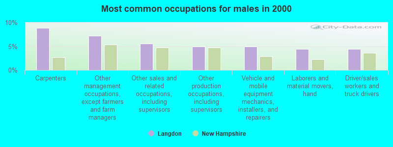
- Carpenters (8.9%)
- Other management occupations, except farmers and farm managers (7.2%)
- Other sales and related occupations, including supervisors (5.6%)
- Other production occupations, including supervisors (5.0%)
- Vehicle and mobile equipment mechanics, installers, and repairers (5.0%)
- Laborers and material movers, hand (4.4%)
- Driver/sales workers and truck drivers (4.4%)
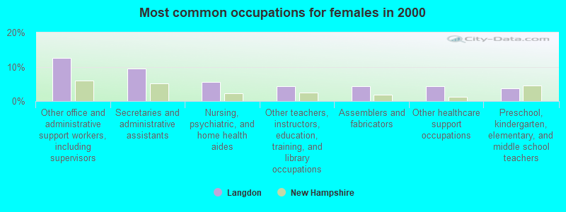
- Other office and administrative support workers, including supervisors (12.6%)
- Secretaries and administrative assistants (9.4%)
- Nursing, psychiatric, and home health aides (5.7%)
- Other teachers, instructors, education, training, and library occupations (4.4%)
- Assemblers and fabricators (4.4%)
- Other healthcare support occupations (4.4%)
- Preschool, kindergarten, elementary, and middle school teachers (3.8%)
Average climate in Langdon, New Hampshire
Based on data reported by over 4,000 weather stations


(lower is better)
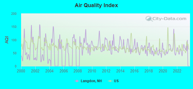
Air Quality Index (AQI) level in 2022 was 59.0. This is better than average.
| City: | 59.0 |
| U.S.: | 72.6 |
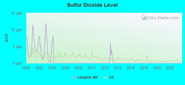
Sulfur Dioxide (SO2) [ppb] level in 2003 was 3.66. This is significantly worse than average. Closest monitor was 9.9 miles away from the city center.
| City: | 3.66 |
| U.S.: | 1.51 |
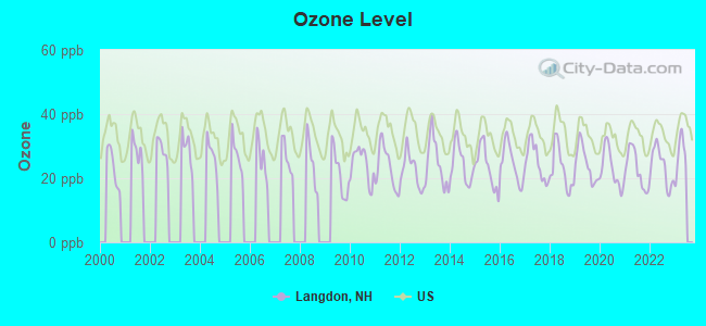
Ozone [ppb] level in 2022 was 23.7. This is significantly better than average. Closest monitor was 13.9 miles away from the city center.
| City: | 23.7 |
| U.S.: | 33.3 |
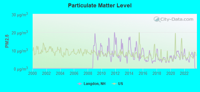
Particulate Matter (PM2.5) [µg/m3] level in 2022 was 5.97. This is better than average. Closest monitor was 13.9 miles away from the city center.
| City: | 5.97 |
| U.S.: | 8.11 |
Tornado activity:
Langdon-area historical tornado activity is slightly above New Hampshire state average. It is 40% smaller than the overall U.S. average.
On 8/20/1968, a category F3 (max. wind speeds 158-206 mph) tornado 21.5 miles away from the Langdon town center injured one person and caused between $5000 and $50,000 in damages.
On 6/9/1953, a category F4 (max. wind speeds 207-260 mph) tornado 49.3 miles away from the town center killed 90 people and injured 1228 people and caused between $50,000,000 and $500,000,000 in damages.
Earthquake activity:
Langdon-area historical earthquake activity is significantly above New Hampshire state average. It is 70% smaller than the overall U.S. average.On 10/7/1983 at 10:18:46, a magnitude 5.3 (5.1 MB, 5.3 LG, 5.1 ML, Class: Moderate, Intensity: VI - VII) earthquake occurred 112.2 miles away from Langdon center
On 4/20/2002 at 10:50:47, a magnitude 5.3 (5.3 ML, Depth: 3.0 mi) earthquake occurred 113.9 miles away from the city center
On 4/20/2002 at 10:50:47, a magnitude 5.2 (5.2 MB, 4.2 MS, 5.2 MW, 5.0 MW) earthquake occurred 113.1 miles away from Langdon center
On 1/19/1982 at 00:14:42, a magnitude 4.7 (4.5 MB, 4.7 MD, 4.5 LG, Class: Light, Intensity: IV - V) earthquake occurred 45.7 miles away from Langdon center
On 10/16/2012 at 23:12:25, a magnitude 4.7 (4.7 ML, Depth: 10.0 mi) earthquake occurred 91.9 miles away from Langdon center
On 6/17/1991 at 08:53:16, a magnitude 4.1 (4.0 MB, 4.0 LG, Depth: 3.1 mi) earthquake occurred 122.0 miles away from the city center
Magnitude types: regional Lg-wave magnitude (LG), body-wave magnitude (MB), duration magnitude (MD), local magnitude (ML), surface-wave magnitude (MS), moment magnitude (MW)
Natural disasters:
The number of natural disasters in Sullivan County (28) is a lot greater than the US average (15).Major Disasters (Presidential) Declared: 18
Emergencies Declared: 9
Causes of natural disasters: Storms: 13, Floods: 12, Snows: 4, Winter Storms: 4, Hurricanes: 3, Blizzard: 1, Ice Storm: 1, Landslide: 1, Snowfall: 1, Snowstorm: 1, Tropical Storm: 1, Wind: 1, Other: 1 (Note: some incidents may be assigned to more than one category).

Hospitals and medical centers near Langdon:
- MCGIRR NURSING HOME (Nursing Home, about 5 miles away; BELLOWS FALLS, VT)
- SPRINGFIELD HEALTH AND REHAB (Nursing Home, about 12 miles away; SPRINGFIELD, VT)
- CHESHIRE COUNTY HOME (Nursing Home, about 14 miles away; WESTMORELAND, NH)
- CEDARCREST INC (Hospital, about 16 miles away; KEENE, NH)
- KEENE CENTER, GENESIS HEALTHCARE (Nursing Home, about 16 miles away; KEENE, NH)
- VALLEY REGIONAL HOSPITAL Critical Access Hospitals (about 16 miles away; CLAREMONT, NH)
- CHESHIRE MEDICAL CENTER Acute Care Hospitals (about 16 miles away; KEENE, NH)
Amtrak stations near Langdon:
Colleges/universities with over 2000 students nearest to Langdon:
- Keene State College (about 18 miles; Keene, NH; Full-time enrollment: 5,098)
- Franklin Pierce University (about 32 miles; Rindge, NH; FT enrollment: 2,139)
- Dartmouth College (about 38 miles; Hanover, NH; FT enrollment: 6,030)
- NHTI-Concord's Community College (about 44 miles; Concord, NH; FT enrollment: 2,865)
- Mount Wachusett Community College (about 45 miles; Gardner, MA; FT enrollment: 3,143)
- Saint Anselm College (about 46 miles; Manchester, NH; FT enrollment: 2,059)
- Southern New Hampshire University (about 48 miles; Manchester, NH; FT enrollment: 16,552)
Public high school in Langdon:
- FALL MOUNTAIN REGIONAL HIGH SCHOOL (Students: 653, Location: 134 FMRHS RD., Grades: 9-12)
Public elementary/middle school in Langdon:
- SARAH PORTER SCHOOL (Students: 27, Location: 111 VILLAGE RD., Grades: 1-4)
Points of interest:
Notable locations in Langdon: Condon Cor (A), Langdon Fire and Rescue (B), Langdon Town Hall (C). Display/hide their locations on the map
Churches in Langdon include: Langdon Congregational Church (A), Langdon Meeting House (B). Display/hide their locations on the map
Cemetery: West Cemetery (1). Display/hide its location on the map
Lake: Middle Pond (A). Display/hide its location on the map
Streams, rivers, and creeks: Robinson Brook (A), Little Brook (B), Great Brook (C), Darby Brook (D). Display/hide their locations on the map
| This town: | 2.4 people |
| New Hampshire: | 2.5 people |
| This town: | 71.6% |
| Whole state: | 66.3% |
| This town: | 8.2% |
| Whole state: | 8.3% |
Likely homosexual households (counted as self-reported same-sex unmarried-partner households)
- Lesbian couples: 0.4% of all households
- Gay men: 0.4% of all households
| This town: | 3.8% |
| Whole state: | 6.5% |
| This town: | 1.4% |
| Whole state: | 2.8% |
Banks with branches in Langdon (2011 data):
- Connecticut River Bank, National Association: Fall Mountain Branch at Route 123, branch established on 1979/05/21. Info updated 2008/07/16: Bank assets: $267.5 mil, Deposits: $242.4 mil, headquarters in Springfield, VT, positive income, Commercial Lending Specialization, 11 total offices, Holding Company: Connecticut River Bancorp, Inc.
For population 15 years and over in Langdon:
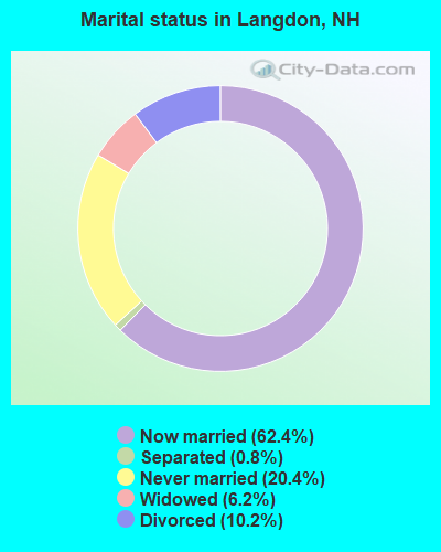
- Never married: 20.4%
- Now married: 62.4%
- Separated: 0.8%
- Widowed: 6.2%
- Divorced: 10.2%
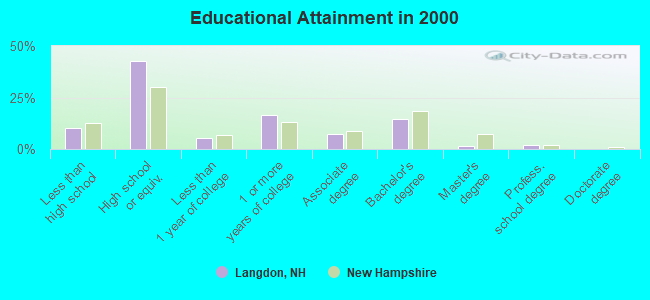
For population 25 years and over in Langdon:
- High school or higher: 89.7%
- Bachelor's degree or higher: 18.1%
- Graduate or professional degree: 3.3%
- Unemployed: 3.4%
- Mean travel time to work (commute): 27.8 minutes
| Here: | 8.8 |
| New Hampshire average: | 10.9 |
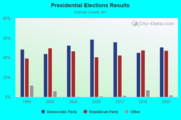
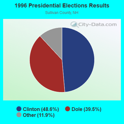
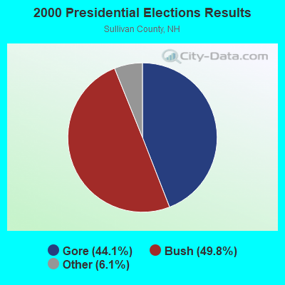
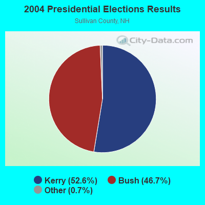
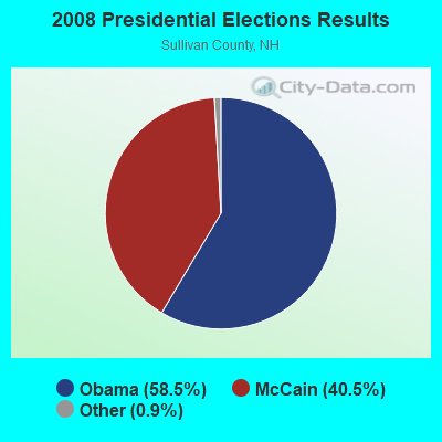
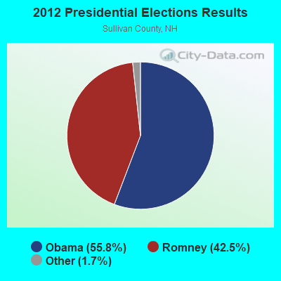
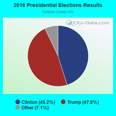
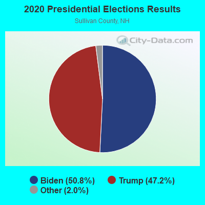
Graphs represent county-level data. Detailed 2008 Election Results
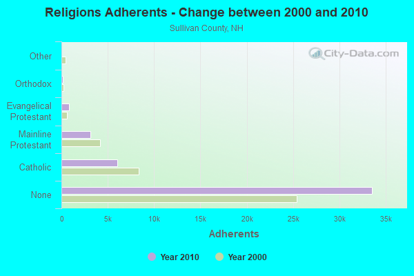
Religion statistics for Langdon, NH (based on Sullivan County data)
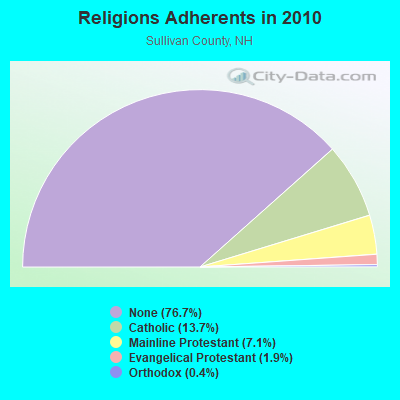
| Religion | Adherents | Congregations |
|---|---|---|
| Catholic | 6,008 | 1 |
| Mainline Protestant | 3,118 | 28 |
| Evangelical Protestant | 849 | 14 |
| Orthodox | 185 | 2 |
| Other | 29 | 2 |
| None | 33,553 | - |
Food Environment Statistics:
| This county: | 1.41 / 10,000 pop. |
| State: | 2.14 / 10,000 pop. |
| Sullivan County: | 0.23 / 10,000 pop. |
| New Hampshire: | 0.15 / 10,000 pop. |
| This county: | 1.41 / 10,000 pop. |
| New Hampshire: | 1.78 / 10,000 pop. |
| Here: | 6.34 / 10,000 pop. |
| New Hampshire: | 4.02 / 10,000 pop. |
| Sullivan County: | 4.93 / 10,000 pop. |
| New Hampshire: | 9.70 / 10,000 pop. |
| Here: | 8.0% |
| New Hampshire: | 7.6% |
| This county: | 26.9% |
| New Hampshire: | 24.4% |
| Sullivan County: | 18.5% |
| New Hampshire: | 15.9% |
Strongest AM radio stations in Langdon:
- WNBX (1480 AM; 5 kW; SPRINGFIELD, VT)
- WNTK (1020 AM; 10 kW; NEWPORT, NH; Owner: KOOR COMMUNICATIONS, INC.)
- WKBK (1290 AM; 5 kW; KEENE, NH; Owner: SAGA COMMUNICATIONS OF NEW ENGLAND, LLC)
- WNNZ (640 AM; 50 kW; WESTFIELD, MA; Owner: CLEAR CHANNEL BROADCASTING LICENSES, INC.)
- WCRN (830 AM; 50 kW; WORCESTER, MA; Owner: CARTER BROADCASTING CORPORATION)
- WRKO (680 AM; 50 kW; BOSTON, MA; Owner: ENTERCOM BOSTON LICENSE, LLC)
- WEEI (850 AM; 50 kW; BOSTON, MA; Owner: ENTERCOM BOSTON LICENSE, LLC)
- WGY (810 AM; 50 kW; SCHENECTADY, NY; Owner: CLEAR CHANNEL BROADCASTING LICENSES, INC.)
- WVNE (760 AM; daytime; 25 kW; LEICESTER, MA; Owner: BLOUNT MASSCOM, INC.)
- WKOX (1200 AM; 50 kW; FRAMINGHAM, MA; Owner: CAPSTAR TX LIMITED PARTNERSHIP)
- WBIX (1060 AM; 40 kW; NATICK, MA; Owner: LANGER BROADCASTING CORPORATION)
- WALE (990 AM; 50 kW; GREENVILLE, RI; Owner: NORTH AMERICAN BROADCASTING CO., INC.)
- WWZN (1510 AM; 50 kW; BOSTON, MA; Owner: ROSE CITY RADIO CORPORATION)
Strongest FM radio stations in Langdon:
- WZSH (107.1 FM; BELLOWS FALLS, VT; Owner: GREAT NORTHERN RADIO, L.L.C.)
- WHDQ (106.1 FM; CLAREMONT, NH; Owner: GREAT NORTHERN RADIO, L.L.C.)
- WKNE (103.7 FM; KEENE, NH; Owner: SAGA COMMUNICATIONS OF NEW ENGLAND, LLC)
- WEVN (90.7 FM; KEENE, NH; Owner: NEW HAMPSHIRE PUBLIC RADIO, INC.)
- WVPR (89.5 FM; WINDSOR, VT; Owner: VERMONT PUBLIC RADIO)
- WCFR-FM (96.3 FM; WALPOLE, NH; Owner: GREAT NORTHERN RADIO, LLC)
- WVRR (101.7 FM; NEWPORT, NH; Owner: CAPSTAR TX LIMITED PARTNERSHIP)
- WJJR (98.1 FM; RUTLAND, VT; Owner: 6 JOHNSON ROAD LICENSES, INC.)
- WZRT (97.1 FM; RUTLAND, VT; Owner: CAPSTAR TX LIMITED PARTNERSHIP)
- WEQX (102.7 FM; MANCHESTER, VT; Owner: NORTHSHIRE COMMUNICATIONS, INC.)
- WJAN (95.1 FM; SUNDERLAND, VT; Owner: 6 JOHNSON ROAD LICENSES, INC.)
- WXKK (93.5 FM; SPRINGFIELD, VT; Owner: CLEAR CHANNEL BROADCASTING LICENSES, INC.)
- WEBK (105.3 FM; KILLINGTON, VT; Owner: 6 JOHNSON ROAD LICENSES, INC.)
- WCMK (91.9 FM; PUTNEY, VT; Owner: CHRISTIAN MINISTRIES INC)
- WGLV (91.7 FM; WOODSTOCK, VT; Owner: CHRISTIAN MINISTRIES INC)
- WHDQ-FM1 (106.1 FM; RUTLAND, VT; Owner: GREAT NORTHERN RADIO, L.L.C.)
- WVAY (100.7 FM; WILMINGTON, VT; Owner: GREAT NORTHERN RADIO, L.L.C.)
- WFEX (92.1 FM; PETERBOROUGH, NH; Owner: FNX BROADCASTING OF NEW HAMPSHIRE LLC)
- W293AB (106.5 FM; KEENE, NH; Owner: GREAT NORTHERN RADIO, L.L.C.)
- WTPL (107.7 FM; HILLSBORO, NH; Owner: CONCORD BROADCASTING, L.L.C.)
TV broadcast stations around Langdon:
- WEKW-TV (Channel 52; KEENE, NH; Owner: UNIVERSITY OF NEW HAMPSHIRE)
- WVTA (Channel 41; WINDSOR, VT; Owner: VERMONT ETV, INC.)
- WNNE (Channel 31; HARTFORD, VT; Owner: HEARST-ARGYLE STATIONS, INC.)
- W17CI (Channel 17; CLAREMONT, NH; Owner: UPPER VALLEY BROADCASTING, LLC)
- National Bridge Inventory (NBI) Statistics
- 5Number of bridges
- 26ft / 7.6mTotal length
- $15,710,000Total costs
- 2,278Total average daily traffic
- 71Total average daily truck traffic
- 3,369Total future (year 2042) average daily traffic
FCC Registered Amateur Radio Licenses:
3- Call Sign: NX1DX, Previous Call Sign: KB1JHG, Licensee ID: L00626930, Grant Date: 09/14/2016, Expiration Date: 12/09/2026, Certifier: Vincent F Augustinowicz, Registrant: Vincent F Augustinowicz, Langdon, NH 03602
- Call Sign: KB1ONZ, Licensee ID: L01250576, Grant Date: 12/03/2016, Expiration Date: 02/26/2027, Certifier: Michael R Holmes, Registrant: Michael R Holmes, 539 Holden Hill Rd, Langdon, NH 03602-8214
- Call Sign: KC1DIX, Licensee ID: L01928582, Grant Date: 03/13/2015, Expiration Date: 03/13/2025, Certifier: Shawn B Doyle, Registrant: Shawn B Doyle, 265 Holden Hill Rd, Langdon, NH 03602
FAA Registered Aircraft:
1- Aircraft: BUCKEYE AVIATION DREAM MACHINE (Category: Land, Seats: 2, Weight: Up to 12,499 Pounds), Engine: ROTAX 582SER (65 HP) (2 Cycle)
N-Number: 85458, N85458, N-85458, Serial Number: 3538, Year manufactured: 1996, Airworthiness Date: 01/11/2008, Certificate Issue Date: 09/27/2007
Registrant (Individual): Kurt E Achenbach, Po Box 610, Langdon, NH 03602
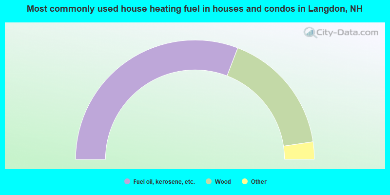
- 61.6%Fuel oil, kerosene, etc.
- 33.6%Wood
- 3.8%Bottled, tank, or LP gas
- 0.9%Electricity
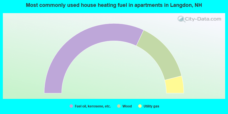
- 64.0%Fuel oil, kerosene, etc.
- 28.0%Wood
- 8.0%Utility gas
Langdon compared to New Hampshire state average:
- Unemployed percentage significantly below state average.
- Black race population percentage significantly below state average.
- Hispanic race population percentage below state average.
- Foreign-born population percentage below state average.
- Renting percentage significantly below state average.
- Length of stay since moving in significantly above state average.
- Number of rooms per house significantly below state average.
- House age significantly below state average.
- Percentage of population with a bachelor's degree or higher below state average.

|
Total of 7 patent applications in 2008-2024.